Keeping a Close Eye on the Storm - NASA Earth Observatory
←
→
Page content transcription
If your browser does not render page correctly, please read the page content below

Keeping
                                                        a Close E
                                                                  ye
                                                  on the S
                                                          torm

In September 1900, a severe hurricane surprised        Today, NASA watches hurricanes from the moment they
the residents of Galveston, Texas. Telephones          form. Scientists track them as they grow, move across
were scarce. There were no satellites. Weather         the ocean, and make landfall. Specialized sensors on
forecasting was relatively new. It was hard to         satellites have allowed them to look inside storms to
see such storms coming and even harder to              see how they work. This information helps forecasters
predict their paths. The result was the deadliest      better predict future hurricanes. Other data help
hurricane in U.S. history.                             governments assess the damage after storms pass.

                                                                                              Hurricane Dorian
                                                                                             September 2, 2019

                                                                  Why do hurricanes have names?
                                                                  Since 1953, every hurricane has been given
                                                                  a name. Naming hurricanes makes them
                                                                  easier to remember. It also makes it easier
  Astronauts onboard the International Space Station (ISS)        for people to keep track of multiple storms
  have a unique view of storms. With sustained winds of           that are happening at the same time. Every
  300 kilometers (185 miles) per hour, Dorian was one of          six years the list of names repeats, unless a
  the strongest hurricanes to ever strike the Bahamas.            hurricane is very deadly or costly. Then the
                                                                  name is retired.

www.nasa.gov                                                               earthobservatory.nasa.gov/eokids
Seeing Storms from Space
    Tropical storms can intensify to become hurricanes, typhoons, or cyclones. All are large storms, but their
    names tell us where on Earth they form. Hurricanes form over the Atlantic and Eastern Pacific Oceans.
    Typhoons form over the Western Pacific. Cyclones form over the Indian Ocean and South Pacific.

                                      Hurricanes                                                         Tropic of Cancer
                                                                                            Typhoons
                         Hurricanes

                                                                     Cyclones
                                                                                                         Tropic of Capricorn

                                                                                                         Known storm tracks
                                                                                           October 25, 1842 - January 14, 2016

      Nearly one third of the world’s tropical storms
      form in the Western Pacific each year. This is
      because the surface waters are among the
      warmest in the world and there are fewer land
      barriers to slow down a storm. The tropopause
      is very high and cold here, which means that
      the moist ocean air can rise higher into the
                                                                                                       Atlantic Ocean
      atmosphere and grow into taller, stronger storms.

    Warming Water                                                                                                27.8 °C
                                                                                                                 Temperatures at
    No matter which ocean, these storms all form in                                                              or above this level
                                                                                                                 fuel and strengthen
    the tropics. But why there? The Sun’s rays shine                  Gulf of Mexico
                                                                                                                 tropical storms
    most directly on the tropics throughout the year,
    so the water is warmer than most other places
    on Earth. In the Atlantic and eastern Pacific,
                                                                                       Caribbean Sea
    ocean temperatures are warmest between June                                                                         July 14, 2020
    and November. This is when most hurricanes                                   Sea Surface Temperature (°C)
    form. Scientists have found that hurricanes need                               Cool                Warm
    ocean temperatures to be at least 27.8°C (82°F).                        10                 21       27.8    32
    Satellites measure sea surface temperatures,
                                                               In July 2020, the Atlantic Ocean had a lot of fuel for
    which helps meteorologists know where there is             hurricanes to form.
    enough energy to fuel a hurricane.

      Vocabulary
      tropics — The region between the geographic Tropic of Cancer (23°26" north latitude) and Tropic of Capricorn
      (23°26" south latitude).
      tropopause — The boundary between the lower atmosphere and the stratosphere.

2
Inside the Hurricane                                                                                                         May 16, 2015

Air temperatures inside a storm are also
important. As moist air rises, it grows cooler
as it moves higher into the atmosphere. This                                                 Typhoon Dolphin
affects the type of precipitation that forms
within the storm. Cold temperatures in the
clouds create ice crystals, but the warmer air
at lower altitudes melts the ice, creating rain.
                                                                                                                 eye
Satellites can use radar (microwave radiation)
to collect data on how much precipitation
there is within different parts of a storm. It
can also detect the eye of the storm – the
center where there are very few clouds.
                                                                        20
Information like this helps scientists better

                                                        altitude (km)
                                                                        15
understand storm structures and why they

                                                                                                           eye
                                                                        10
produce more or less rain.                                              5    Freezing line

                                                                        0

                                                        CloudSat makes a cross-section of the inside of storms.
Rainfall Rates & Stalling Storms
Though most people talk about the strength of hurricane winds, flooding is the leading cause of death
from these storms. Specialized NASA satellites measure the amount of rain dropped by a storm.
As global air and water temperatures rise, our atmosphere can hold more moisture. This means some
storms bring more precipitation today than in the past. If a storm stalls and hovers over the same area
longer, even more rain can fall in one place and the strong winds can cause damage for a longer time.
Those data can be turned into maps of where rainfall was heaviest.

  Soil Moisture Active Passive (SMAP)                             Global Precipitation Measurement (GPM)               7:30 p.m. August 28

                              Soil Moisture on
                             August 27 (cm3/cm3)
                                                                                                                  +
                               0.0      ≥0.4

                 Hurricane Harvey stalled in 2017 and dropped more than 1500 mm (60 inches) of rain on parts
                 of Texas. This map (left) shows soil moisture data after the storm; the map on the right shows
                 satellite rainfall estimates. The ground became so saturated that it led to widespread flooding. As
                 of 2020, Harvey holds the record for most rainfall from a single hurricane in the U.S.

                                                                                                                                             3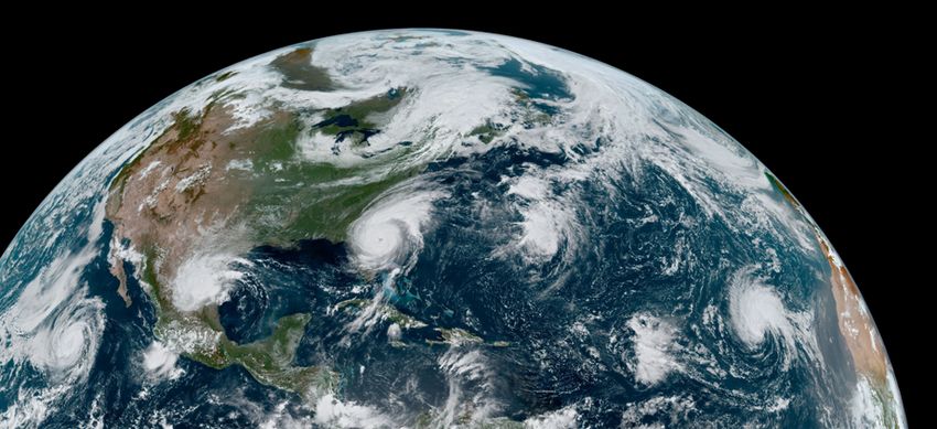
Tracking Storms
Geostationary weather satellites like GOES-16 (built by NASA and operated by NOAA) track the movement
of storms every few minutes, day and night. This helps the National Weather Service predict when and
where severe storms may strike.
Because it can see a wide view of Earth,
GOES-16 can track multiple storms at a
time. In 2019, four tropical storms
headed for different parts of North
America at the same time.
Dorian
Fernand
Gabrielle
Juliette
Assessing the Aftermath
Storm surges and rainfall cause flooding. Strong winds and downed trees can knock out power. NASA
satellites make it possible to compare images of our cities and lands before and after a hurricane. This
can be useful to rescue and recovery efforts and for rebuilding later.
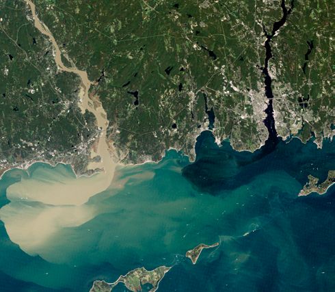
Thames River August 25, 2017
Tortola
Connecticut River
St. Thomas
St. John
September 10, 2017
Long Island Sound Tortola
St. Thomas
September 2, 2011
St. John
Nearly a week after Hurricane Irene drenched
New England, the Connecticut River was
spewing large amounts of muddy sediment into Lush islands in the Caribbean turned from green to
Long Island Sound. brown after being battered by Hurricane Irma.
Vocabulary
storm surge — When the winds and waves from a storm push more water up along the coast.
4
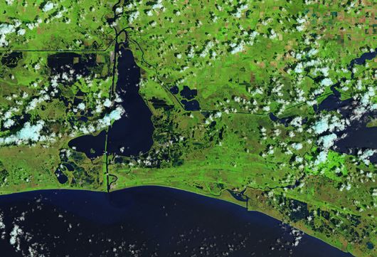
Calcasieu                                                 Calcasieu
                  Lake                                                      Lake

August 13, 2020 (Before)                                  August 29, 2020 (After)

Before and After Hurricane Laura
Hurricane Laura struck Louisiana and Texas in August 2020. Storm surges ranged from 3 to 5 meters (9 to
15 feet). The storm dropped 12 to 25 cm (5 to 10 inches) of rain in many places. Satellite images helped spot
areas that were flooded.

 Hurricanes and Pets
 People use to have to leave their pets behind during
 evacuations from natural hazards. After Hurricane
 Katrina in 2005, the U.S. Congress passed a law to
 keep pets with their owners in case of evacuation. The
 National Weather Service suggests that pet owners
 have a safety plan just like people.

Before and After Tropical Cyclone Idai
Comparing nighttime satellite images can make it easy to spot blackouts and areas in need of assistance.

Mozambique
March 9, 2019 (Before)                                    March 24, 2019 (After)

                      Manga                                                         Manga

    Beira                     Macuti                           Beira                        Macuti

                                                                                                                5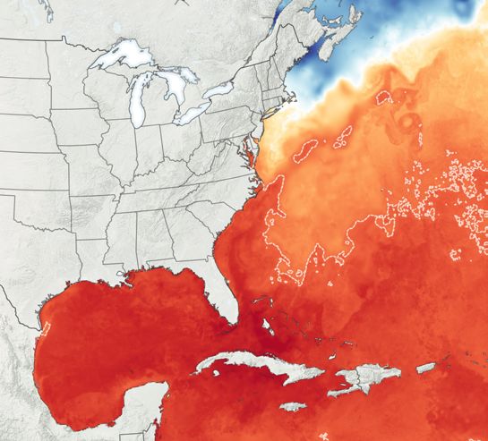
ie n  ce
    DIY Scoof Structures
                                                Can you design a structure
                                                that can sustain strong
                                                winds? Design and test your

    Storm-Pr
                                                structure.

                                                Materials:
      Instructions:                             •   Index cards (4-8)
                                                •   Straws (~10)
      Your challenge is to build, as tall
                                                •   Craft sticks (4-8)
      as possible, a freestanding tower
                                                •   String (~1 meter/~3 feet)
      that can support a tennis ball while
      withstanding the wind from a fan.         •   Pipe cleaners (4-8)

      1. Design your structure. What            •   Tape

      materials do you need? What shape         •   Scissors
      will it be?                               •   Ruler

      2. Collect your materials and build       •   Tennis ball
      your tower.                               •   Paper and pencil

      3. Place the tennis ball on top of your   •   Fan with speed settings
      completed tower.
      4. Place the fan 25 centimeters away
      from your tower and turn it on low
      speed to simulate a tropical storm.
      5. If your tower did not fall over, try
      increasing the fan's speed.

      Did your tower survive
      your “tropical storm”
      or “hurricane” winds?
      Why or why not?

      Saffir Simpson Scale
      The Saffir-Simpson Scale is
      used to classify hurricanes by
      their wind speeds. The faster
      the wind speed, the greater
      the potential for destruction.

6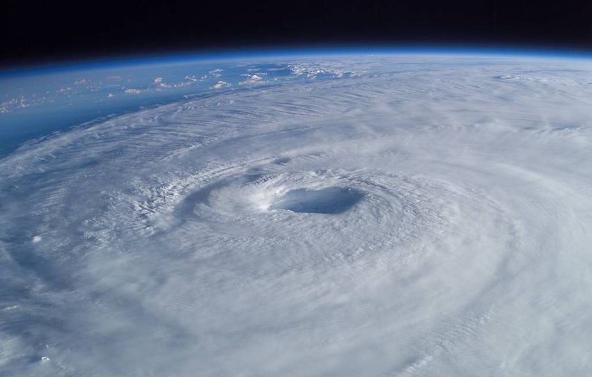

You can also read