Report on TYPHOON YOLANDA (HAIYAN) Philippines - Super Typhoon Haiyan, As Seen From Space
←
→
Page content transcription
If your browser does not render page correctly, please read the page content below
Super Typhoon Haiyan, As Seen From Space

      Typhoon Haiyan approaching the Philippines Copyright
                      2013 JMA/EUMETSAT
     http://www.popsci.com/article/science/big-pic-super-typhoon-haiyan-seen-space

Report on TYPHOON YOLANDA (HAIYAN)
              Philippines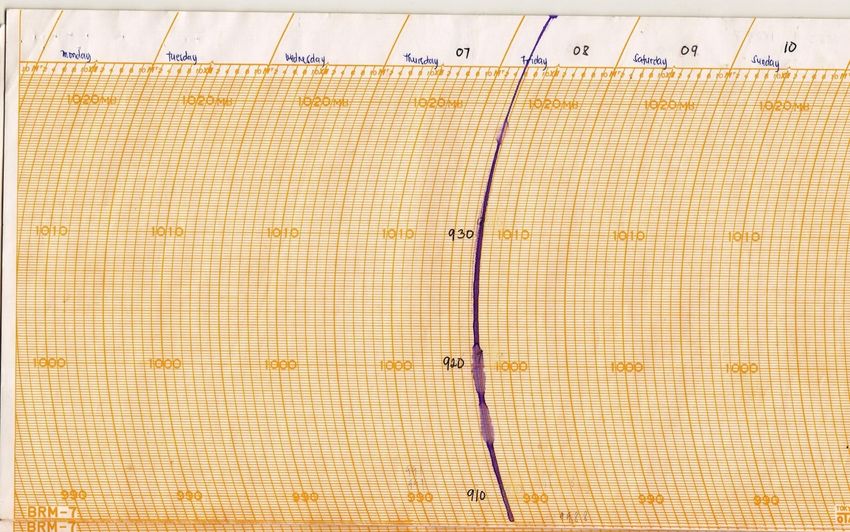
Philippine tropical cyclone climatology Tropical cyclones which affect the country directly (landfalling) or indirectly usually forms over the warm waters of the Pacific Ocean on the east and at rare occasions, over the West Philippine Sea on the west.
Philippine tropical cyclone climatology

      And I am reporting
      somewhere over here now!

Consolidated tropical cyclone track within the PAR for the period 1951 – 2000.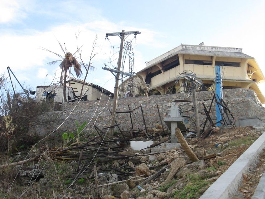
Average tropical cyclone tracks (1948-2005)
250

                                         Number of Landfalling TC's
                             200
Number of TropicalCyclones

                                         Number of non-Landfalling TC's       80     67
                             150                                                          77

                                                                                                 88
                             100
                                                                                                       87
                                                                       46           130
                                                                             126                             47
                              50                                                          111
                                                                30
                                                                                                 71
                                   10      6      9      18            48                              44    36
                                                                34
                                   17      13     9      11
                              0
                                   Jan     Feb    Mar    Apr   May     Jun    Jul   Aug   Sep   Oct   Nov   Dec
      Monthly
      Mean                         0.5    0.3    0.3     0.5   1.1    1.6    3.4    3.3   3.1   2.7   2.2   1.4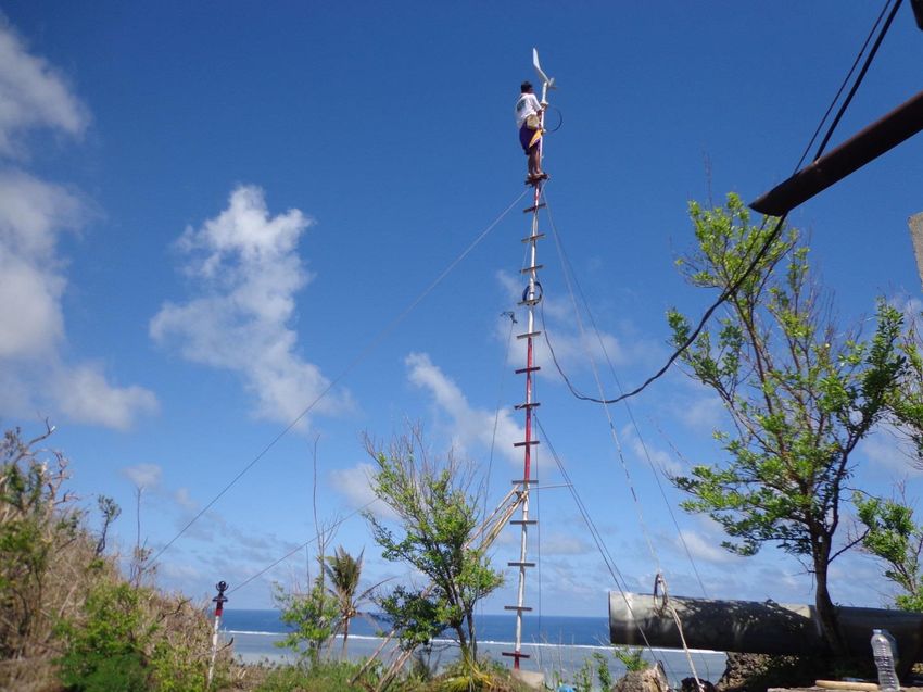
Frequency of Tropical Cyclones in
   the Philippines (1948-2005)

                        Northern Luzon is
                        most frequently
                        hit by tropical
                        cyclones followed
                        by Catanduanes
                        and Northern
                        Samar and least in
                        the Mindanao
                        area.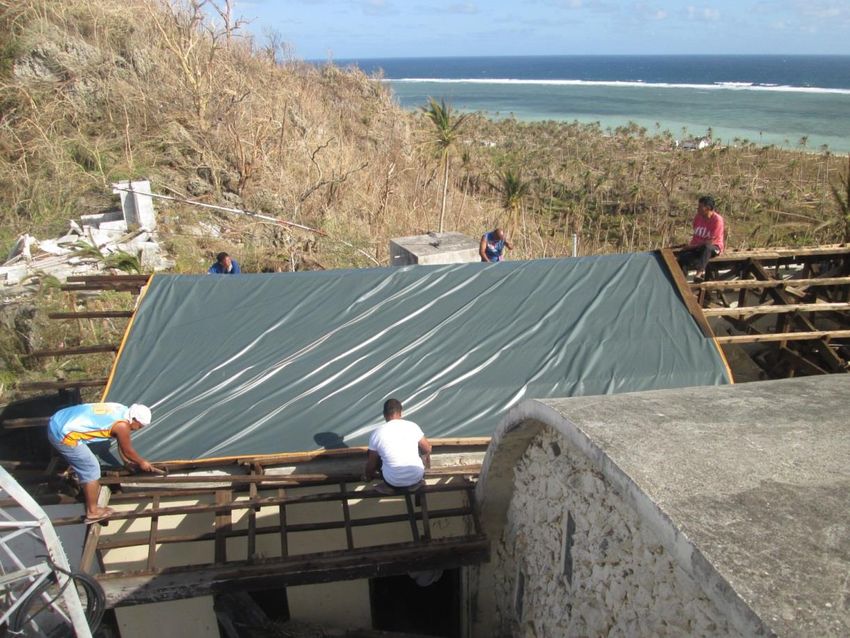
Chronology of PAGASA Activities                               07 Nov 2013:                    06 Nov 2013:
                                                              • Deployed STRIDE Team to       • Issued Regular Severe
                                                                Sorsogon                        Wx. Bulletin although
09 Nov 2013:           08 Nov 2013:                           • Emphasized that a storm         the TY was still outside
• PSWS #3 and #4       • Auxilliary bulletin was issued at      surge of 5-7 meters is          PAR
  were lowered           2AM to include other areas in          expected over the coastal     • Presented in the
  after Haiyan           Central Visayas and Southern Luzon     areas in provinces of           NDRRMC meeting the
  crossed Visayas        under PSWS#4 due to acceleration       Surigao, Dinagat , Samar        forecast track of TY
  islands and            of Haiyan                              and Leyte, Sorsogon,            Haiyan and possible
  continued to         • 4:40AM, Haiyan made landfall over      Masbate, Northern Cebu          impacts
  move away from         Guiuan, Eastern Samar                  and Bohol                     • Press conference -
  the country          • 11PM, Haiyan exits the landmass of   • Conferred w/ the President      PAGASA emphasized
• Final bulletin was     N. Palawan after crossing Central      who called for a                that PSWS No. 4 will be
  issued at 3:30PM       Visayas and Southern Luzon area        nationwide preparation for      issued and storm surge
  as Typhoon                                                    the strong TY & stressed        is expected.
  Haiyan exits PAR.                                             the occurrence of storm       • Assigned a
                                                                surge particularly in areas     meteorologist at the
                                                                along its path                  NDRRMC
                                                              • Provided Hourly updates         Operation Center
                                                                on the location and           • Dispatched 2
                                                                intensity                       meteorologists to Iloilo
                                                              • Press conference/ press       • Dispatched 2 radar
                                                                briefings every 6 hours         technicians to Hinatuan
                                                                until Nov. 9                    Radar operation.
                                                              • TY Haiyan intensified &
                                                                                              05 Nov - Issued initial
                                                                accelerated as it moved
                                                                                              Weather Advisory
                                                                closer to landmass
                                                                                              - Visayas PRSD alerted
                                                                                              the media & Prov. Gov. of
                                                                                              Cebu & Bohol
                                                                                              approaching TY
TYPHOON YOLANDA (HAIYAN)
                               November 6 – November 10, 2013

    Bulletin No. 8                                                    Bulletin No. 4
    @4pm, Nov 8, 2013                                                 @4pm, Nov 7, 2013
                                                 Bulletin No. 5
                                                 @10pm, Nov 7, 2013
                 Bulletin No. 6
                                                                       Bulletin No. 3
                 @4am, Nov 8, 2013
                                                                       @10am, Nov 7, 2013
                                         Bulletin No. 5-A
                                         @1am, Nov 8, 2013
    Bulletin No. 11                                                         Bulletin No. 2
    @10am, Nov 9, 2013                                                      @4am, Nov 7, 2013

Bulletin No. 12                                                              Bulletin No. 1
@10am, Nov 9, 2013                                                           @10pm, Nov 6, 2013

    Bulletin No. 10
    @4am, Nov 9, 2013

          Bulletin No. 9             Bulletin No. 4-A
          @10pm, Nov 8, 2013         @6pm, Nov 7, 2013

              Bulletin No. 7
              @10am, Nov 8, 2013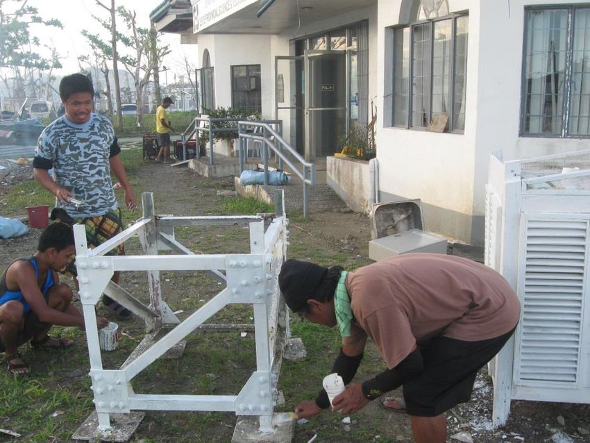
Typhoon HAIYAN “YOLANDA”
6-9 November 2013 (23rd TC in PAR in 2013)
Forecast Track vs. Actual Track

Actual track      Forecast track
OBSERVED DATA

     STATION        MAX SUS.   GUSTINESS
                     WINDS
Guiuan, Eastern      160 kph    195 kph
Samar
Roxas City           130 kph    205 kph
Coron, Palawan       55 kph     160 kph
San Jose, Mindoro    75 kph     120 kph
BAROGRAPH READING AT GUIUAN STATION ON NOV. 8, 2013
Lowest pressure in Guiuan Station = 910 hPa
- Observed at 5:00AM, Nov.8, 2013
- Equivalent to 240 kph max. sustained winds
and 280 kph gustinessTY Yolanda vs TY Reming
Typhoon Reming: Nov. 30, 2006
Elevation Max Winds Remarks
Virac Radar 230 m 320 kph
Virac Synop 40 m 270 kph
Typhoon Yolanda: Nov. 8, 2013
Guiuan Radar 60 m 280 kph 910 hPa Using
barograph
Note: Winds increases exponentially with altitude
If Guiuan is at a the same height of Virac radar, the wind of TY
Yolanda estimated to be 20% stronger: Max. winds = 336 kph
TY Yolanda is the strongest typhoon.Highest Storm surge output of the JMA model run by PAGASA
TC Tracks in November 1912 and November 2013 (Typhoon Yolanda)

 Source : H. Kubota, 2014
Source : H. Kubota, 2014
Sources: European Commission Copernicus Emergency
                                                                                                        Areas where structures were:
I                                            Management Service; OpenStreetMap
                                                                                                           Destroyed
                                                                                                           Heavily damaged
M   PORT AREA
                                                                                                           Less than heavy damage or status
                                                                                                           unknown
                                                            PORT
P   Several ships washed onto shore near a
    warehouse complex north of the city’s
                                                                                                       1/2 MILE

A   downtown.
    DOWNTOWN
    People lined up for supplies in a downtown
C   plaza, where debris from surrounding
                                                                                         Destroyed amphitheater

    buildings littered the streets.
T
                                                                                  AIRPORT
S                                                                                 The tiny peninsula where
                                                                                  the Tacloban airport is
                                                                                  located was devastated.
                                                                                                                                   AIRPORT
                                                                                  AIRPORT
    DEVASTATED COASTLINE                                                          All that remained of the
    Buildings near the fish port were                                             airport was the runway.
    leveled by the storm surge, which sent                                        People lined up during the
    water over half a mile inland in some                                         day hoping for fresh water,
    places.                                                                       food or a flight out.
    Homes all along the coast were
    completely destroyed. According to the
    Philippine census office, about one third
    of homes in the city have wooden
    exterior walls, and one in seven have
                                                         TACLOBAN
    grass roofs
                                                                                       www.baronservices.com.
    FLOODED AREAS
    Neighborhoods south of the city’s downtown
    were inundated with water.
I M P A C T S The central portion of the town of Dulag with multiple structures and tree cover visible intact in pre-crisis image (top) collected prior to Typhoon Haiyan. As of 10 November 2013 (bottom) most structures are gone with proximate debris indicative of complete destruction, and most tree cover likewise destroyed.
I
Tacloban City
M Google/Digital/Globe Google/Digital/Globe
P
A
C
T
S
Before Before
Google/Digital/Globe Google/Digital/Globe
www.baronservices.com.
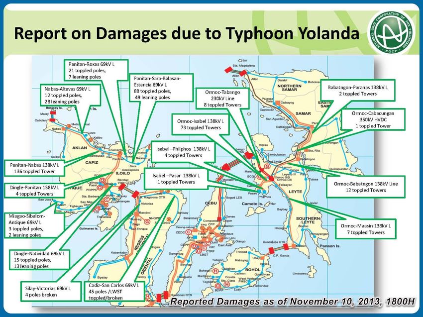
After AfterImpacts: Toppled towers of National Grid Corporation of the PH
Toppled:
40
transmissio
n towers
2000 poles
Estimated cost
of damage:
PhP5 billion
(USD119 M)
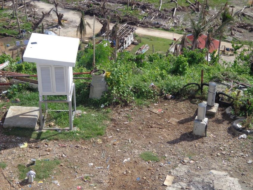
Source: NGCPImpacts: Damaged PAGASA Doppler radar in Guiuan, Eastern
Samar
photo - credit: AFP Central Command from their Facebook
page:
https://www.facebook.com/media/set/?set=a.35670128446730
6.1073741835.323973651073403&type=1Impacts: Damaged PAGASA synoptic stations
(source: PAGASA Storm Chasers)
PAGASA Tacloban synoptic station
PAGASA Guiuan synoptic & radar stationList of Damaged PAGASA stations & facilities (P74.24M=44.24(bldg&eqpt) +30M(bouy))
Station/facility Damage Remarks
1. Tacloban Synoptic Building and Equipment totally damaged Operation suspended
2. Coron Synoptic Building and Equipment totally damaged Operation suspended
3. Guiuan Radar and Old and new radar equipment totally damaged Operation suspended for 1 week.
Synoptic while buildings were partially/totally damaged; all Operation resumed for rainfall and
basic meteorological instruments were totally visual observation. Installed solar
damaged except standard 8” raingauge panel for temporary lighting system
and radio communication
4. Catbalogan Synoptic Building partially damaged Installed solar panel for temporary
lighting system and radio
communication. Repaired genset.
5. Borongan synoptic Broken glass windows
6. Maasin synoptic No communication Restore communication after a week
7. Roxas synoptic Observer quarter and station unroofed; power line
and PLDT (telephone) connection cut down;
thermometer shelter unroofed, antennae
connection and wirings were lost.
8. Cuyo synoptic Radio antennae mast bent down
9. San Jose (Occidental Thermometer shelter unroofed
Mindoro) synoptic
10. Mambusao Agromet Perimeter shelter of station and thermometer
shelter damaged, outside gutter fell down
11. Visca Agromet Thermometer shelter blown down, rain gauge
damaged; sunshine instrument realigned.
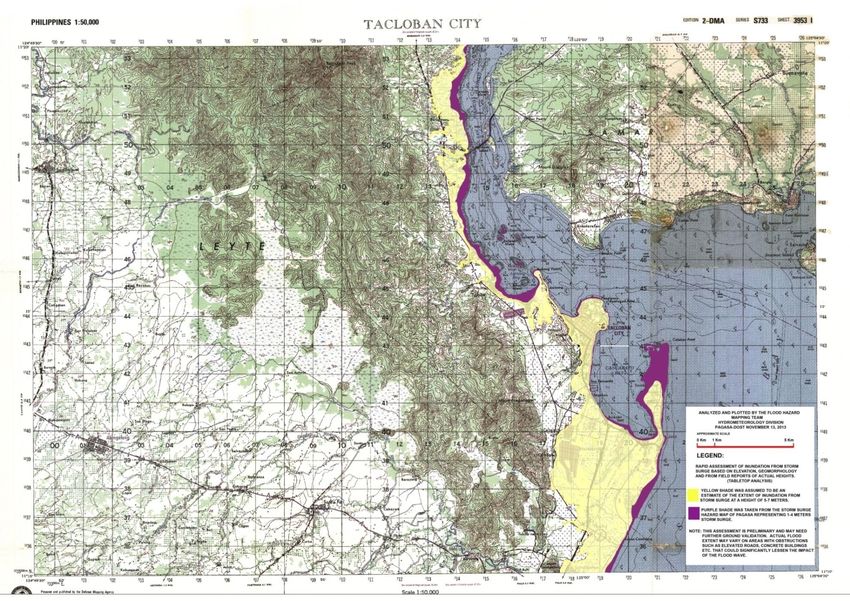
12. Met Buoy (Madridejos, Totally damaged All sensors were retrieved andEstimated extent of inundation resulting from the forecast 5-7m storm surge
Assessment Report
                      (PAGASA STORM CHASER Team)
1. Typhoon Haiyan made landfall in Guiuan Eastern Samar specifically over
    Homonhon & Suluan Islands. The last recorded pressure before landfall
    at Guiuan station was 910.0 hPa. At this pressure, the equivalent
    maximum sustained wind is 240kph near the center and gustiness up
    to 280kph.
2. Based on interviews and actual observations in the area, the eye of
     Typhoon Haiyan passed between municipalities of Dulag and Tolosa,
     Leyte between 5am to 6am of Nov 8, 2013.
3. The provinces of Leyte and Eastern Samar were devastated by Typhoon
     Haiyan and the associated storm surge.
    - Tacloban to Palo Leyte 5 to 6 meters with inundation of 600 to 800
      meters.
    - Basey Samar 5 to 6 meters with inundation of 600 to 800 meters.
    - Guiuan to Hernani Eastern Samar 6 to 7 meters with inundation of 800
      to 1000 meters.
    - In Tacloban PAGASA station, 2 container vans which were intended as
      temporary shelter for PAGASA staff were carried by the storm surge 100
      meters away.
AREAS COVERED DURING ASSESSMENT Conducted interviews and surveys Occular inspection
• Check/validate the reported height of the storm surge

 BGY 60-C OLD RD
 SAGCAHAN, TACLOBAN

WaterLevel
ACTUAL SURGE HEIGHT= 6.4M

BGY. BARAS, PALO
LEYTE
Actual Storm Surge Height (above msl)
                BGY/MUNICIPALITY                LAT         LON         H (msl)   INUNDATION

1    Bgy. Baras, Palo, LEYTE                 11° 09.848' 125° 00.510'    6.39        800

2    Bgy 60C Old Rd Sagcahan, TACLOBAN       11° 13.556' 125° 00.242'    5.75        600

3    Bgy 88 San Jose, TACLOBAN               11° 12.656' 125° 01.604'    6.27        500

4    Bgy San Jose, Dulag, LEYTE              10° 59.108' 125° 02.347'    2.85        200

5    Bgy Baybay, Basey E. Samar              11° 17.021' 125° 04.277'    5.53        500

6    Bgy Catadman, Basey E. SAMAR            11° 16.290' 125° 09.164'    5.39        800

7    Bgy. Sulangan, Guiuan, E. SAMAR         10° 57.820' 125° 49.724'    7.14        800

8    Bgy Sapao, Guiuan, E. SAMAR             11° 02.835' 125° 45.524'    3.94        300

9    Bgy Aguinaldo Gen McArthur, E. SAMAR    11° 13.279' 125° 32.028'    2.26         80

10   Bgy. Batang, Hernani, E. SAMAR          11° 17.958' 125° 36.162'    6.61        800

11   Bgy 4 & 3 Poblacion Hernani, E. SAMAR   11° 19.384' 125° 37.040'    6.77        1000

12   Bgy 3 Katabauan, Balangkayan, E. SAMAR 11° 28.048' 125° 30.428'     6.96        800
Activities of the PAGASA Response Teams • Basic instruments from destroyed Tacloban station were installed at the DOST Region 8 Office in Palo, Leyte • Three (3) solar panels were put up for temporary lighting system and radio communication (SSB) at DOST R8 in Palo, Leyte, in Catbalogan and Guiuan stations. • Repaired water line at Guiuan station • Repaired the generator sets of Tacloban, Catbalogan and Catarman stations • Repaired and re-installed all basic instruments in all affected PAGASA stations
TACLOBAN STATION
Basic met instruments are installed at
a new site, at DOST Region 8 Office in
Palo, Leyte
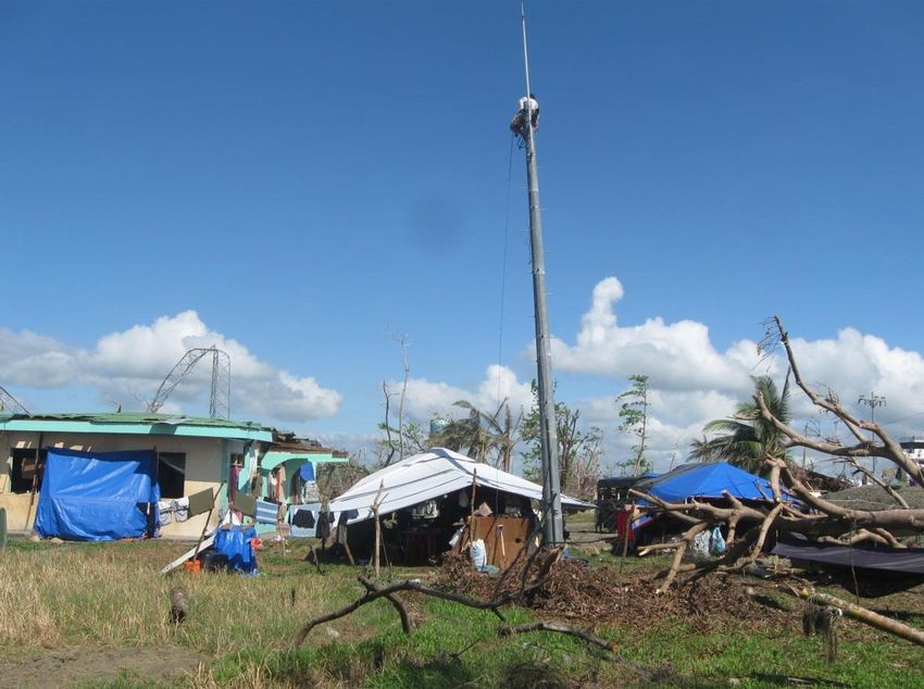
GUIUAN
THANK YOU!
       Website:
www.pagasa.dost.gov.ph

      Facebook:
  www.facebook.com/
  pagasa.dost.gov.ph

       Twitter:
     @dost_pagasa
You can also read