8 AM EDT Tuesday, September 3, 2019 Major Hurricane Dorian, Potential Tropical Cyclone #7, Invest 91L (90%), Invest 92L (40%) & African
←
→
Page content transcription
If your browser does not render page correctly, please read the page content below
Tropical Update

                             8 AM EDT
                    Tuesday, September 3, 2019
         Major Hurricane Dorian, Potential Tropical Cyclone
          #7, Invest 91L (90%), Invest 92L (40%) & African
                            Wave (60%)
This update is intended for government and emergency response officials, and is provided for informational and situational
awareness purposes only. Forecast conditions are subject to change based on a variety of environmental factors. For
additional information, or for any life safety concerns with an active weather event please contact your County Emergency
Management or Public Safety Office, local National Weather Service forecast office, or visit the National Hurricane Center
website at www.hurricanes.gov.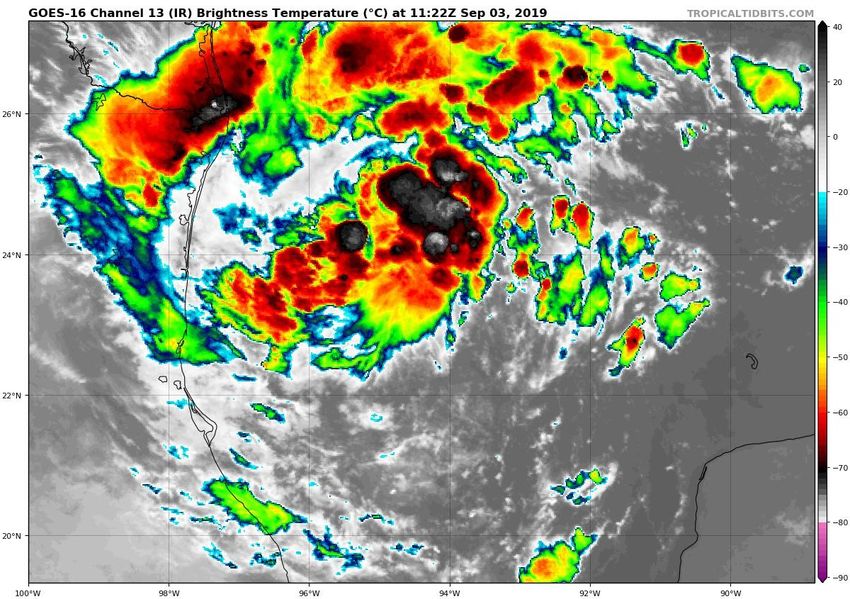
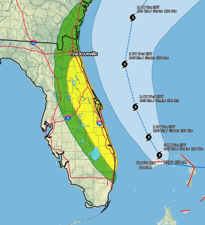
Major Hurricane Dorian                                          Tuesday, September 3, 8 AM ET
                      MINIMAL    LOW   MODERATE   HIGH     EXTREME       National Hurricane Center Map
             Winds

        Storm Surge

        Flash Flood

         Tornadoes

                           LOW         MODERATE          HIGH

Changes Since Yesterday:
- Dorian is now a Category 3 hurricane with maximum sustained winds of 120 mph, but the wind field is expanding.
- Very little movement occurred overnight and Dorian is remains nearly stationary near Grand Bahama Island.
- Tropical Storm Warnings now in effect for Duval and Nassau Counties. A Storm Surge Warning is now in effect from
  northern Palm Beach County northward to the FL/GA line.
Hurricane Dorian is located about 105 miles east of
                                  West Palm Beach. It has moved very little overnight,
                                  but its current motion is northwest 1 mph. Maximum
                                  sustained winds have decreased to 120 mph, making
                                   Dorian a Category 3 Hurricane. Dorian is forecast to
                                      remain a major hurricane for the next 2 days.

                                   A slow north-northwestward motion will continue
                                   this morning. A faster forward motion is expected
                                      later today. A turn to the north is forecast by
                                  Wednesday evening, followed by a turn to the north-
                                    northeast Thursday morning. On this track, the
                                    core of Hurricane Dorian will continue to pound
                                  Grand Bahama Island today. The hurricane will then
                                    parallel the Florida east coast late today through
                                    Wednesday evening, very near the Georgia and
                                       South Carolina coasts Wednesday night and
                                  Thursday, and near or over the North Carolina coast
                                                       late Thursday.

                                    Hurricane force winds extend 45 miles from the
                                  center and tropical storm force winds extend up to
                                                       160 miles.
Hurricane Dorian Forecast Track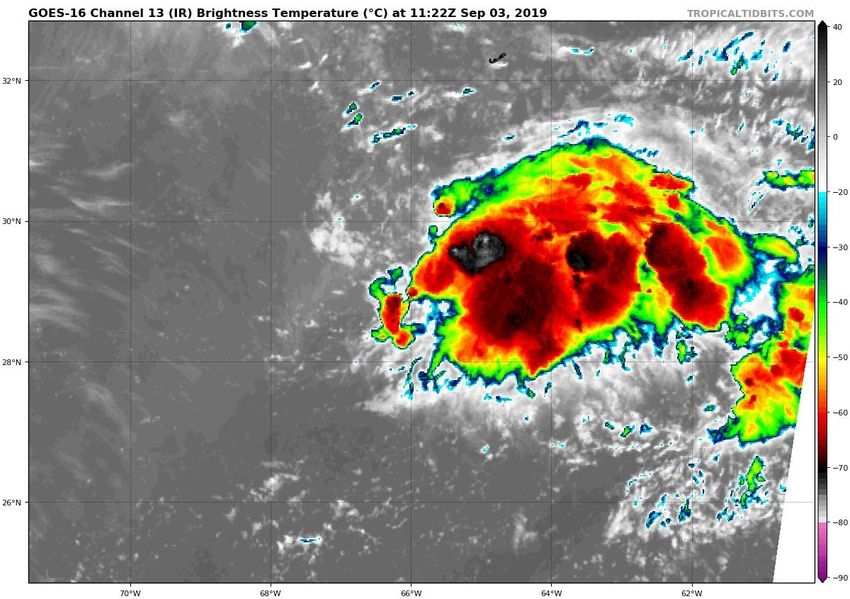
Hurricane Warning in effect for St.
                                             Johns, Flagler, coastal Volusia, Brevard,
                                               Indian River, St. Lucie, and Martin
                                                             Counties

                                              Hurricane Watch for coastal Nassau,
                                             coastal Duval, and coastal Palm Beach
                                                            Counties

                                               Tropical Storm Warning for inland
                                               Nassau, inland Duval, Clay, Putnam,
                                              eastern Marion, Lake, inland Volusia,
                                                  Seminole, Orange, Osceola,
                                             Okeechobee, and Palm Beach Counties

                                                 Tropical Storm Watch for Polk,
                                             Highlands, Glades and coastal Broward
                                                            Counties
Hurricane Warning   Tropical Storm Warning
Hurricane Watch     Hurricane Watch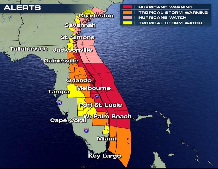
8pm Wedneday
                           Wind Timing Estimates

2pm Wednesday              Note: Assumes a perfect
    8am Wednesday        forecast. Winds will come in
                             intermittent bands.
      2am Wednesday
                           Winds will slowly expand
       8pm Tuesday      northward along the Treasure
          2pm Tuesday
                        Coast today and then expand
                         into the Space Coast tonight
                         through sunrise Wednesday.

                        Conditions should improve for
                        the Treasure Coast by sunrise
                        Wednesday, with winds exiting
         8pm                the state by midnight
                              Wednesday night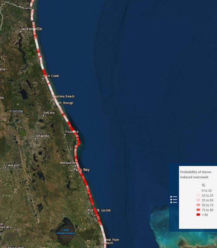
https://www.weather.gov/srh/tropical?
              office=mfl
  Click on “Threats and Impacts” Tab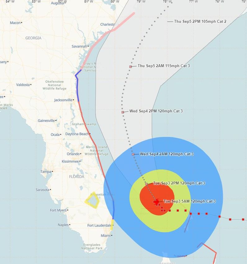
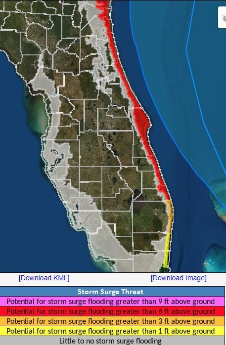
Storm Surge Forecasts
          Watches/Warnings
• Storm Surge Warning
     – Nassau, Duval, St. Johns, Flagler,
       Volusia, Brevard, Indian River, St. Lucie,
       Martin, northern Palm Beach Counties

• Storm Surge Watch
     – Southern Palm Beach County

https://www.nhc.noaa.gov/refresh/graphics_at5+shtml/155815.shtml?
inundation#contents
Interactive P-Surge Inundation Map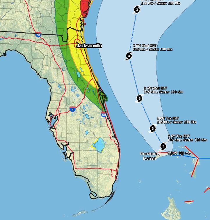
USGS Modeling
• Probability of overwash,
  or the likelihood that wave
  runup and storm surge
  will overtop the dune
  crest, during Hurricane
  Dorian
Rainfall
Forecast Next 5
     Days
Dorian is forecast to bring 2-6”
of rain to the Florida East Coast
    through the next 5 days.

Given the recent stretch of wet
weather, these rainfall amounts
  could still create urban and
 minor river flooding along the
           East Coast.

The highest rainfall totals will be
  near the coast, and likely in
       Northeast Florida.
Flash Flood Outlooks Tuesday Wednesday
River Observations/Forecasts Across the Peninsula
                              Rivers Currently in or Forecast to
                                 Reach Minor Flood Stage:
                          •   Santa Fe River at Worthington Springs
                          •   Santa Fe River at O’Leno State Park
                          •   Santa Fe River near Fort White
                          •   Santa Fe River at Three Rivers Estates
                          •   Withlacoochee River at Holder
                          •   Cypress Creak at Worthington Gardens
                          •   Peace River at Zolfo Springs
                          •   St. Johns River above Lake Harney
                          •   St. Johns River at Astor
                          •   St. Johns River at Racy Point
                          •   Ocklawaha River at Rodman Dam
                          •   Dunns Creek near Satsuma
St. Johns River at Astor – Moderate Flooding
• 3.5 feet: Many yards and streets along the
river, and with canals flooded, water enters the
first floor of low lying homes. Flooding to
docks and yards at condominiums on Juno Trail
and docks at Astor Bridge Marina. Roads
flooded in South Moon Fish Camp and starting
to move over the sea wall at Blair’s Jungle Den.
• 3 feet: Moderate flooding, with water covering
yards and further encroaching on many low
lying homes near the river. Flooding of many
yards and low lying roads near the river.
• 2.8 feet: Docks and boat ramps covered at
South Moon Fish Camp and approaching sea
wall at Blair’s Jungle Den.
• 2.3 feet: Minor flooding of low lying streets
and yards north of Fox Road on Lake County
side of Astor, and from River Road northward
on Volusia side of river. Water begins to cover
docks at South Moon Fish Camp.
• 2 feet: Water begins to move into yards and
cover boat ramps in low lying areas along the
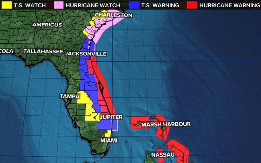
river.• PTC #7 could become a depression today and a tropical storm just before landfall in Mexico on Wednesday.
Invest 91L is expected to become a tropical
depression later today and could become a
tropical storm tomorrow while moving
northwest in the eastern Atlantic.
Invest 92L is still rather disorganized. There is still a small
window of opportunity for development within the next 48
hours before conditions become unfavorable and a frontal
system moves it quickly northeast.
West African Wave: A tropical wave is forecast to emerge over the far eastern tropical Atlantic between Africa and the Cabo
Verde Islands in a few days. Models indicate a good potential for development late this week or this weekend. A general
westward movement across the eastern and central Atlantic is expected for next week.
Summary
Major Hurricane Dorian
• At 8 AM ET Tuesday, Hurricane Dorian was still located 105 miles east of West Palm Beach, and now drifting northwest at
  1mph.
• Hurricane hunters have found that maximum sustained winds are near 120 mph, which is a Category 3 Major Hurricane.
  Dorian is forecast to maintain Category 3 intensity through Wednesday.
• Dorian will begin a slightly faster north-northwest movement today, and a further increase in forward motion is expected later
  today as it parallels the Florida East Coast.
• Dorian’s wind field is expanding and tropical storm conditions are expected the continue through Wednesday night, with
  hurricane force gusts possible later today.
• Dorian is forecast to also parallel the Georgia and South Carolina coasts on Thursday.

•   Invest 91L: A tropical wave near the Cabo Verde Islands is expected to develop today as it moves northwestward over the
    open waters of the eastern tropical Atlantic. It has a 90% (high) chance of becoming a tropical storm during the next 5 days.
•   Invest 92L: An area of low pressure south of Bermuda could develop as it slowly moves northward near Bermuda. It has a
    40% (medium) chance of becoming a tropical depression during the next 2 days.
•   PTC #7 (formerly Invest 93L): An area of low pressure in the southwestern Gulf of Mexico could become a tropical depression
    today as it moves slowly westward toward northeastern Mexico. It has a 100% (high) chance of formation during the 2 days.
•   African Wave: A tropical wave over western Africa will emerge into the Atlantic later this week. Once it does so, the National
    Hurricane Center gives it a 60% (medium) chance of development.
Florida Outlook:
• Parts of east central and northeast Florida remain in the 3-day forecast cone.
• A Hurricane Warning is in effect for St. Johns, Flagler, coastal Volusia, Brevard, Indian River, St. Lucie, and Martin Counties
• A Storm Surge Warning is in effect for Nassau, Duval, St. Johns, Flagler, Volusia, Brevard, Indian River, St. Lucie, Martin, and northern Palm Beach
Counties
• A Tropical Storm Warning is in effect for inland Nassau, inland Duval, Clay, Putnam, eastern Marion, Lake, inland Volusia, Seminole, Orange, Osceola,
Okeechobee, and Palm Beach Counties
• A Hurricane Watch is in effect for coastal Nassau, coastal Duval, and coastal Palm Beach Counties
• A Storm Surge Watch is in effect for southern Palm Beach County.
• A Tropical Storm Watch is in effect for Polk, Highlands, Glades, and coastal Broward Counties
• Damaging winds, storm surge, flash flooding, and isolated tornadoes are all possible with Dorian, but the severity of the impacts will be dependent on
how close to the coast the storm tracks.
• Tropical storm force gusts are already occurring in Southeast Florida in some of the feeder bands. These will continue spreading up the East Coast
through tonight and Wednesday. Hurricane force gusts will be possible along parts of east central Florida tonight into Wednesday.
• Storm Surge values north of Jupiter Inlet are forecast to be 4-7’, with 2-4’ south of Jupiter Inlet.
• In addition, large battering waves in excess of 10-15’ are already causing erosion and coastal flooding during high tide. This will continue through
Wednesday.
• Rainfall amounts of 2-6” are expected along the East Coast. This may cause minor flooding issues along with post-landfall river/creek flooding.
• Minor river flooding is ongoing or forecast along parts of the Santa Fe River, Withlacoochee River, Cypress Creek, Peace River, and the St. Johns River.
However, moderate flooding may occur at the St. Johns River at Astor.
• None of the 4 systems being monitored for development currently poses a threat to Florida. The next names on the 2019 Atlantic storm name list are
Erin, Fernand, Gabrielle and Humberto.
The next tropics packet will be issued Tuesday evening. For the latest information on the tropics, please visit the National Hurricane Center website
at www.hurricanes.gov. For the latest flood updates, see the latest products from your local National Weather Service, the Southeast River Forecast
Center, and the Weather Prediction Center.Tropical Update
Created by:
Amy Godsey, Chief State Meteorologist
Amy.Godsey@em.myflorida.com
State Meteorological Support Unit
Florida Division of Emergency Management
Users wishing to subscribe (approval pending) to this distribution list, register at:
https://public.govdelivery.com/accounts/FLDEM/subscriber/new?topic_id=SERT_Met_Tropics.
Other reports available for subscription are available at:
https://public.govdelivery.com/accounts/FLDEM/subscriber/new?preferences=trueYou can also read