5:00 PM EDT Friday, August 21, 2020 Tropical Storm Laura - Near Lesser Antilles Tropical Depression #14 - Western Caribbean - Fort Myers Beach ...
←
→
Page content transcription
If your browser does not render page correctly, please read the page content below
Tropical Update
                              5:00 PM EDT
                        Friday, August 21, 2020
              Tropical Storm Laura – Near Lesser Antilles
             Tropical Depression #14 – Western Caribbean
                    Tropical Wave Near Africa (30%)
This update is intended for government and emergency response officials, and is provided for informational and situational
awareness purposes only. Forecast conditions are subject to change based on a variety of environmental factors. For
additional information, or for any life safety concerns with an active weather event please contact your County Emergency
Management or Public Safety Office, local National Weather Service forecast office, or visit the National Hurricane Center
website at www.hurricanes.gov.
Tropical Weather Outlook
Possible Areas of Development During the Next 5 Days (LINK)
Atlantic Basin Satellite Image
Chance of development:   None   Low   Medium   High
Color denotes the movement speed through
             Steering Currents             the atmosphere and thin white lines denote
                                              direction. Tightly clustered white lines
             What is moving the systems?       represent faster movement as well.

    A large, strong area of high                                          Fast Moving
   pressure is centered over the                                             Storm
              Atlantic.

  The two systems will continue
  moving west-northwestward.
                                                                          Fast Moving
Once the systems enter the Gulf of                                           Storm
Mexico, the forecast tracks become
uncertain as the current low moves
         out of the South.                                                 Typical
                                                                         Moving Storm

                                                                          Slow Moving
                                                                             Storm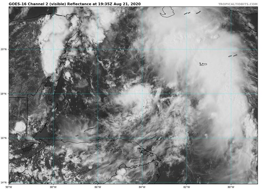
Color denotes the amount of wind shear and
             Wind Shear                                      the lines denote how it have changed over the
                                                               last 24 hours (dotted lines show decreasing
             Is the environment favorable for the systems?        shear and solid lines show increasing.

Wind shear remains relatively
light near Laura & TD 14. The                                                                 HIGH Shear
  wind shear ahead of these                                                                  (Unfavorable)
     systems is forecast to
     decrease, making the
  environment favorable for
                                                                                              HIGH Shear
 intensification if the systems                                                              (Unfavorable)
      remain over water.
                                                                                              MODERATE
                                                                                                 Shear
                                                                                               (Neutral)

                                                                                              LOW Shear
                                                                                              (Favorable)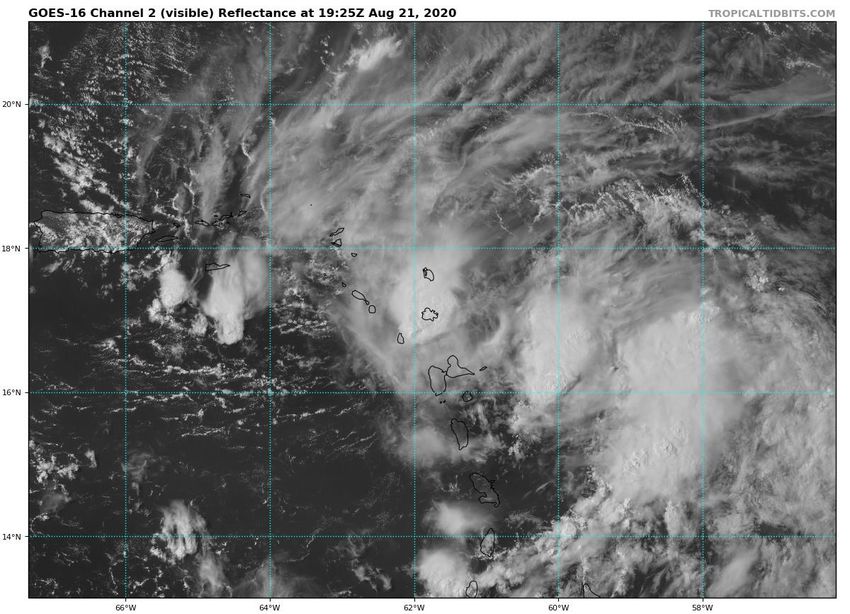
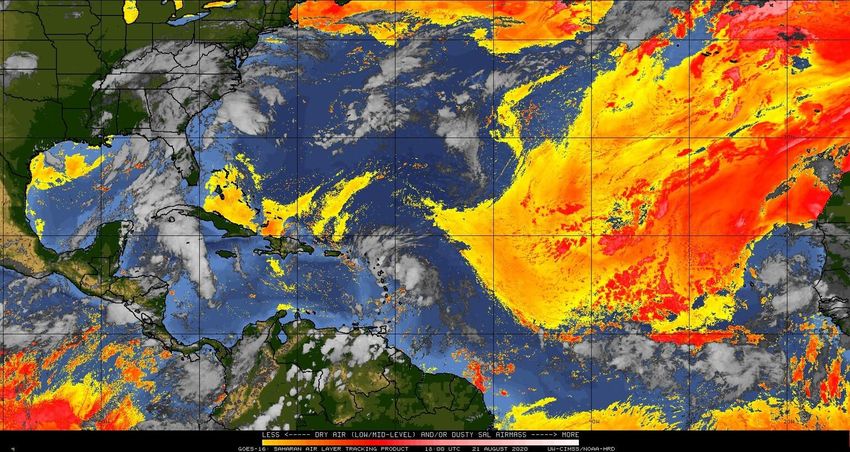
Dry Air & Saharan Dust                                       Color denotes concentration of
 Is the environment favorable for the systems?                Saharan Dust or dry, stable air.

                                          TD 14 has a moist environment ahead. There is
                                            less dry air ahead of Laura than observed
                                          yesterday. The wave near the African coast has
                                                    abundant dry air around it.
             Moist
Moist              Dry
                                                    Very Dry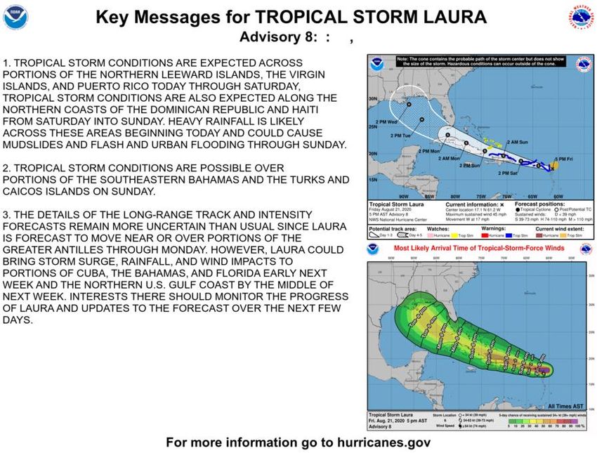
Sea Surface Temperatures & Anomalies
                 Is the ocean favorable for the systems?
   Water temperatures will warm the                                           °F
 further west the systems move and are                                        90
     warmest in the Gulf of Mexico.                                           88
                                                                              86
 Water temperatures are generally above                                       84
normal, supporting tropical development.                                      82
                                                                              81
                                                                              79
                                 Above Normal
                                                                              75
                                                                    81        72

                                                               86
                                                88
                                                      90 86
                                                     86
                                                          84
                                                                    84   82

                                 Below Normal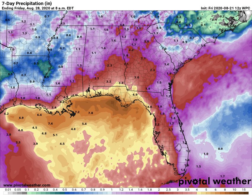
Satellite Imagery
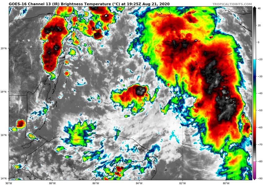
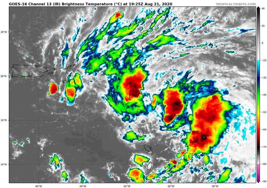
Near Lesser Antilles – Tropical Storm Laura
Tropical Storm Laura remains a disorganized
tropical storm this afternoon. Thunderstorms
have been pulsing and have not consistently
stayed near the center. The most intense
thunderstorms have been to the southeast of
the center.
Official Forecast Track
From the National Hurricane Center – Tropical Storm Laura
                              •   The center of Tropical Storm Laura is located about 40 miles
                                  miles east of the northern Leeward Islands, or about 1,400
                                  miles southeast of Key West, FL.

                              •   Maximum sustained winds remain near 45 mph. Only
                                  gradual strengthening is forecast due to land interaction.
                                  More intensification is possible in the Gulf of Mexico, and
                                  Laura could become a hurricane early next week.

                              •   Laura is moving toward the west at 17 mph, and a general
                                  west-northwest motion at a forward speed is expected.

                              •   Laura will likely come close to the lower Florida Keys on
                                  Monday, and could impact the Panhandle on Wednesday.

                              •   There still remains uncertainty in the forecast intensity due
                                  to potential land interaction.

                              •   Conditions appear favorable for further development in the
                                  Gulf of Mexico. However, if the system gets too close to
                                  Tropical Depression 14, changes to track and intensity are
                                  possible in the Gulf of Mexico.
Time of Arrival & Wind Speed Probabilities
EARLIEST REASONABLE Time of Arrival of Tropical Storm Force Winds (>39 mph)
                                                              Key West: 40% (-1)
                                                              Marathon: 38% (-1)
                                                                Miami: 12% (-1)
                                                           Fort Lauderdale: 19% (-0)
                                                           West Palm Beach: 14% (-1)
                                                             Fort Pierce: 10% (-1)
                                                                Orlando: 3% (-3)
                                                                Naples: 27% (-4)
                      Jacksonville 12%                       Fort Myers: 12% (-3)
                                                                Tampa: 16% (-5)
                                                              Cedar Key: 12% (-7)
                          Orlando 30%
                                                            Apalachicola: 19% (-9)
                                                             Tallahassee: 5% (-6)
                                                            Panama City: 21% (-8)
                            Miami 9%                            Destin: 12% (-5)
                                                              Pensacola: 15% (-2)

                                         Tropical storm force winds may begin as early as Sunday night in
                                           South Florida and the Keys, but will most likely start Monday
                                           morning. Tropical storm force winds will be possible Monday
                                              night into Tuesday across West Central Florida and the
                                                             Panhandle and Big Bend.
Forecast Rainfall Totals Next 7 Days
• A widespread 2-5” expected across the
state this week, with the highest totals in the
Panhandle and Big Bend
• Locally 7-10” especially along the Gulf
Coast
• Storms will be very efficient rainfall
producers, and could produce 2-4” of rain
within an hour.
• There is an isolated flash flood threat each
day across much of the state.
• The flash flood threat may increase next
week in the Panhandle.
• The highest rainfall totals could shift or
change, depending on the track and
intensity of Laura.Key Messages From the National Hurricane Center
Satellite Imagery
Western Caribbean – Tropical Depression #14
                                    Tropical Depression #14 has been producing
                                  disorganized showers and thunderstorms most
                                    of today, but has recently developed storms
                                  near its center. Hurricane Hunters are enroute
                                   to determine if the system has strengthened.
Official Forecast Track
From the National Hurricane Center – Tropical Depression #14
• The center of TD 14 is located about 255 miles southeast of
Cozumel, Mexico
• Maximum sustained winds are at 35 mph, and
strengthening is forecast as the systems moves towards the
western Gulf over the next 3 days.
• TD 14 is moving to the northwest at 13 mph. This general
motion with a slower forward speed is expected over the
next 5 days, for the entire life of the system.
• TD 14 will move into the Gulf of Mexico on Sunday. Landfall
could occur along the Texas or Louisiana coast on Tuesday.
• However, changes to track and intensity are possible in the
Gulf of Mexico depending on Tropical Storm Laura and how
strong the system is able to get over the next 72 hours
before the environment becomes more unfavorable.Time of Arrival & Wind Speed Probabilities
EARLIEST REASONABLE Time of Arrival of Tropical Storm Force Winds (>39 mph)
Tropical storm force winds
could begin along the
Jacksonville 12%
northwestern and central
Orlando 30%
US Gulf Coast as early as
Monday morning, but will
Miami 9% more likely begin Monday
night.Tropical Weather Outlook
Possible Area of Development During the Next 5 Days (LINK)
An area of disorganized cloudiness and showers
located between the west coast of Africa and the
Cabo Verde Islands is associated with a broad area
of low pressure and tropical wave.
This disturbance is expected to move westward at
15 to 20 mph across the Cabo Verde Islands during
the next 24 hours. Conditions are forecast to be
only marginally conducive for some development
over the next couple of days.
After that time, environmental conditions are
expected to become less favorable for
development.
This system does not need to be monitored for
impacts at this time.Overall Summary Tropical Storm Laura – Near the Lesser Antilles • Tropical Storm Laura is located near Antigua, or about 1,400 miles southeast of Key West, FL, moving W at 17 mph. • Maximum sustained winds are near 45 mph. Only gradual strengthening is forecast over the next few days due to land interaction. • The center of Laura will likely pass over or south of the Florida Keys on Monday, then near the Panhandle on Wednesday. • The forecast track and intensity are more uncertain in the Gulf of Mexico due to possible interaction with Tropical Depression #14, but a hurricane is currently forecast in the Gulf of Mexico. Tropical Depression #14 – Western Caribbean • The center of TD 14 is located about 255 miles of Cozumel, Mexico, moving northwest at 13 mph. • Maximum sustained winds are near 35 mph, and this system is expected to become a tropical storm later today and possibly near hurricane strength on Saturday. • TD 14 will near the Yucatan Peninsula on Saturday, emerge into the Gulf of Mexico on Sunday, then make landfall in Texas or Louisiana on Tuesday. • The forecast track and intensity are uncertain as it approaches the northwest Gulf of Mexico due to possible interaction with Tropical Storm Laura and intensity changes. Tropical Wave near the Coast of Africa • A tropical wave moving off the coast of Africa may gradually develop this weekend, but the chances for development have decreased. • The National Hurricane Center gives the system a 20% (low) chance of development over the next 48 hours and a 30% (low) chance of development over the next 5 days.
Florida Summary
Florida Outlook:
• Tropical Storm Laura poses a direct threat to Florida next week.
• Tropical storm force winds are likely to begin by Monday morning in far South Florida and the Florida Keys, but may begin as early as Sunday
    night.
• Tropical storm force winds may begin on Tuesday in the Panhandle, but could begin as early as Tuesday morning.
• Heavy rainfall expected across the state, even before Laura nears the state. A widespread 2-5” of rainfall is expected over the next 7 days
    statewide, especially in the Panhandle and along the Gulf Coast, with localized totals of 7-10” possible.
• Isolated tornadoes will be possible in some of the outer bands across South Florida and the Keys Sunday and Monday, then in North Florida
    late Monday into Tuesday.
• Dangerous rip currents are expected along some Atlantic beaches late this weekend into early next week and along the Gulf Coast early next
    week (in conjunction with swells from TD #14).

•   The forecast across North Florida remains uncertain, as the track continues to shift and Laura may move over Hispaniola and Cuba. In addition
    there may be possible interactions between TS Laura & TD 14.

•   No impacts are expected from the wave over Africa at this time.

•   Unrelated to the tropical systems, a stalled cold front will bring high rain chances to the state over the next couple days. A localized flash flood
    and severe weather threat exists each afternoon.

The next briefing packet will be issued early Monday morning after the 5 AM advisory. For the latest information on the tropics, please visit the
National Hurricane Center website at www.hurricanes.gov.
Tropical Update
Created by:
Cameron Young, Assistant State Meteorologist
Cameron.Young@em.myflorida.com
Michael Spagnolo, Deputy State Meteorologist
Michael.Spagnolo@em.myflorida.com
State Meteorological Support Unit
Florida Division of Emergency Management
Users wishing to subscribe (approval pending) to this distribution list, register at:
https://public.govdelivery.com/accounts/FLDEM/subscriber/new?topic_id=SERT_Met_Tropics.
Other reports available for subscription are available at:
https://public.govdelivery.com/accounts/FLDEM/subscriber/new?preferences=trueYou can also read