Current Watches and Warnings - Aon
←
→
Page content transcription
If your browser does not render page correctly, please read the page content below
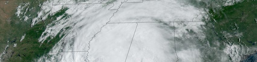
Current Watches and Warnings
A Storm Surge Warning is in effect from the mouth of the Pearl River to the Alabama / Florida border
A Tropical Storm Warning is in effect from the mouth of the Pearl River to the Alabama / Florida border

Current Details from the National Hurricane Center (NHC)
COORDINATES: 31.9° north, 90.7° west
LOCATION: 40 miles (65 kilometers) southwest of Jackson, Mississippi
MOVEMENT: north at 9 mph (15 kph)
WINDS: 40 mph (65 kph) with gusts to 50 mph (80 kph)
RADIUS OF TROPICAL STORM-FORCE WINDS: 195 miles (315 kilometers)
MINIMUM CENTRAL PRESSURE: 996 millibars
SAFFIR-SIMPSON SCALE RANKING: Tropical Storm

LANDFALL LOCATION: near Fourchon, Louisiana (United States)
LANDFALL INTENSITY: 150 mph (240 kph) – Category 4
LANDFALL TIMEFRAME: approximately 11:55 AM local time (16:55 UTC) August 29

Latest Satellite Picture

Source: NOAA / NASA / Colorado State University (RAAMB)

Discussion
Tropical Storm Ida, located approximately 40 miles (65 kilometers) southwest of Jackson, Mississippi, is
currently tracking north at 9 mph (15 kph). The center of Ida has moved farther inland over western
Mississippi this morning and NWS Doppler radar velocities and surface observations indicate that the
tropical cyclone's winds have continued to decrease. The strongest winds are in a band of convection well
southeast of the center along the coasts of Mississippi and Alabama where recent surface reports
indicate winds of nearly 40 mph (65 kph) are still occurring. Based on this data, the NHC has set an initial
intensity at 40 mph (65 kph). As Ida's circulation moves farther inland, additional weakening will continue,
and Ida is expected to become a tropical depression this afternoon. Continued weakening should occur
while Ida moves over the Tennessee Valley on Tuesday, and the system is forecast to become
extratropical over the eastern United States by late Wednesday. The forecast models indicate that the
post-tropical cyclone will be absorbed by a frontal zone over the western Atlantic by the end of the
forecast period.

Ida is moving just east of due north and a north-northeastward turn should occur later today, followed by
a faster northeastward motion tonight and Tuesday as a mid- to upper-level trough approaches the
cyclone from the west. The forecast model guidance remains tightly clustered with very little cross-track
spread, although there remains some speed or along-track spread in the guidance.

Please note that Hurricane Ida has caused extensive wind, storm surge, and inland flood-related
damage across Louisiana. Further damage is anticipated in Mississippi, Alabama, and other
inland states as heavy rains and gusty winds from Ida or its remnants move into the Tennessee
Valley and Mid-Atlantic. A significant financial cost is anticipated, with the direct economic toll
likely to be well into the double-digit billions (USD). A sizeable portion of this total will not be
covered by insurance, including most damage to infrastructure or properties without an active
National Flood Insurance Program (NFIP) policy. Early indications suggest that the insurance
impact – including losses from private and public entities – will also be a double-digit billion
(USD) total. It will take many months or longer for the financial view of this event to fully develop.
Loss estimates will be subject to several revisions as more data is obtained.

Key Messages from the National Hurricane Center

1. Dangerous storm surge inundation will continue into this afternoon along portions of the coasts of
Mississippi and Alabama.

2. Tropical storm force winds, especially in gusts, will continue over portions of southeastern Louisiana,
southern Mississippi and southern Alabama this afternoon.

3. Ida will continue to produce heavy rainfall tonight through Tuesday morning across portions of
southeast Louisiana, Mississippi, and western Alabama, resulting in considerable flash and urban
flooding and significant river flooding impacts. Rivers in the Lower Mississippi Valley will remain elevated
into next week. As Ida moves inland, additional considerable flooding impacts are likely across portions of
the Tennessee Valley, the Ohio Valley, and particularly in the Central and Southern Appalachians into the
Mid-Atlantic through Wednesday.

4. In areas that experienced damage and power loss, individuals should use extreme caution during the
recovery phase. Post-storm fatalities and injuries often result from heart attacks, heat exhaustion,
accidents related to clean up and recovery, and carbon monoxide poisoning from improper generator use.

Cat Alert: Hurricane Ida                                                                                     2
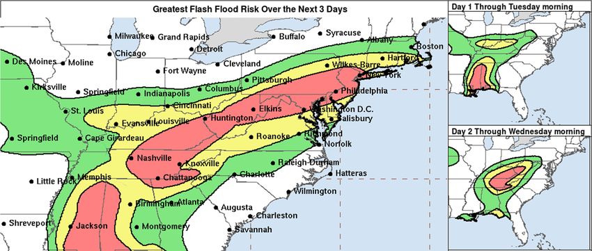
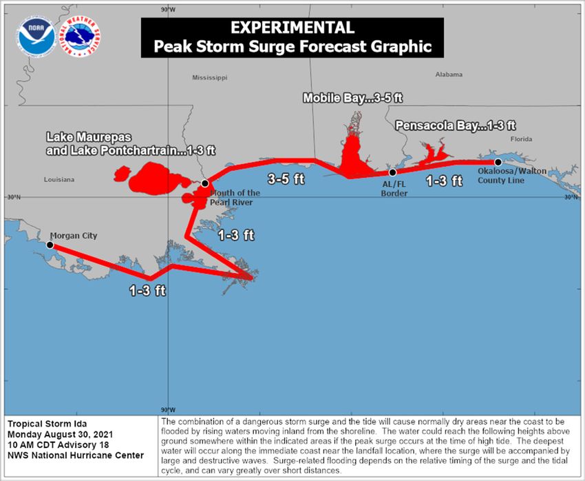
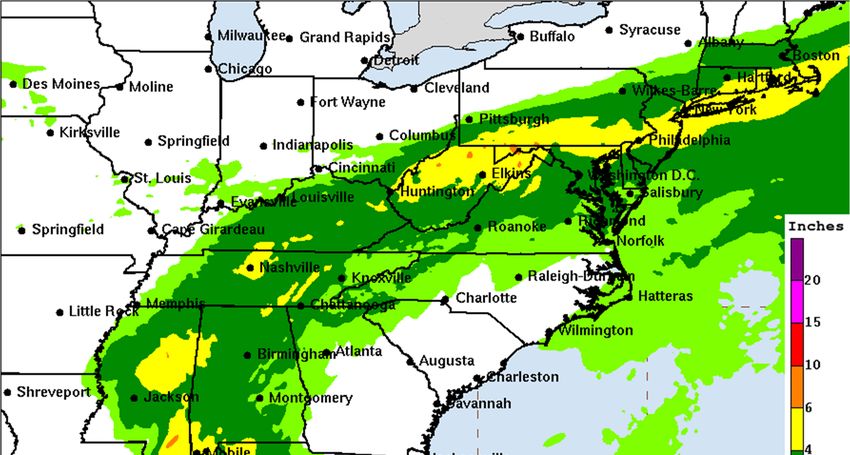
Additional Information

STORM SURGE: The combination of a dangerous storm surge and the tide will cause normally dry areas
near the coast to be flooded by rising waters moving inland from the shoreline. The water could reach the
following heights above ground somewhere in the indicated areas if the peak surge occurs at the time of
high tide:

Mouth of the Pearl River to AL/FL border, including Mobile Bay: 3-5 feet
Morgan City, LA to the Mouth of the Pearl River, including Lake Borgne: 1-3 feet
Lake Maurepas and Lake Pontchartrain: 1-3 feet
AL/FL border to Okaloosa/Walton County Line including Pensacola Bay: 1-3 feet

Surge-related flooding depends on the relative timing of the surge and the tidal cycle and can vary greatly
over short distances.

WIND: Tropical storm conditions will continue over portions of southern Mississippi and southern
Alabama through early afternoon.

RAINFALL: Through Tuesday morning across portions of southeast Louisiana into far southern
Mississippi, Ida will produce additional rainfall totals of 2 to 4 inches with localized higher amounts
possible. Storm total rainfall accumulations of 10 to 18 inches with isolated maximum amounts of 24
inches are expected. Heavy rain combined with storm surge has resulted in catastrophic impacts along
the southeast coast of Louisiana with considerable flash flooding and riverine flooding continuing farther
inland.

Ida will continue to turn northeast this morning and is forecast to track across the Middle Tennessee
Valley, Ohio Valley and Mid-Atlantic through Wednesday, producing the following rainfall totals:

Coastal Alabama to the far western Florida panhandle: An additional 4 to 8 inches resulting in storm total
accumulations of 6 to 12 inches with isolated maximum amounts of 15 inches, today through Tuesday
morning.

Central Mississippi into far western Alabama: 4 to 8 inches with isolated maximum amounts of 12 inches,
today through tonight.

Middle Tennessee Valley, Ohio Valley, Central/Southern Appalachians into the Mid-Atlantic: 3 to 6 inches
with isolated higher amounts, Tuesday into Wednesday.

Considerable flash flooding is possible from the Lower Mississippi Valley through the Middle Tennessee
Valley, Ohio Valley, Central/Southern Appalachians, and into the Mid-Atlantic. Widespread minor to
isolated major riverine flooding is occurring or forecast from the Lower Mississippi Valley into far western
Alabama. Rivers will remain elevated into next week.

TORNADOES: A few tornadoes are possible through tonight, mainly across southeast Mississippi,
southern Alabama, and the western Florida Panhandle. The threat for a few tornadoes will shift east on
Tuesday and become centered across eastern Alabama, western Georgia, and the Florida Panhandle.

SURF: Swells will continue to affect portions of the northern Gulf Coast through today. These swells are
likely to cause life-threatening surf and rip current conditions.

Cat Alert: Hurricane Ida                                                                                       3
National Hurricane Center (NHC) Forecast

Cat Alert: Hurricane Ida                   4
Most Likely Arrival Time of Tropical Storm-Force Winds

Cat Alert: Hurricane Ida                                 5
National Hurricane Center: Wind Speed Probabilities
Tropical Storm-Force Wind Probabilities (≥40 mph (65 kph))

Cat Alert: Hurricane Ida                                     6
NHC: Storm Surge Inundation Graphic

Cat Alert: Hurricane Ida              7
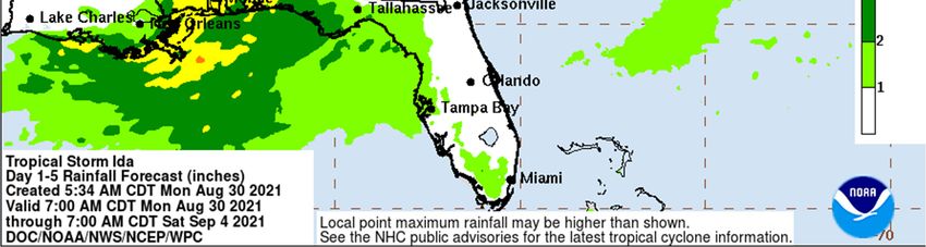
Weather Prediction Center: Rainfall Potential

Cat Alert: Hurricane Ida                        8
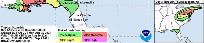
Weather Prediction Center: Flash Flood Potential

Additional Information and Update Schedule
Wind intensity forecasts and forecast track information can be found via the National Hurricane Center at
www.nhc.noaa.gov

NEXT CAT ALERT: Since continued weakening will occur while tracking further inland, this will be the
final Cat Alert. A comprehensive review will be found in this week's Weekly Cat Report.

Cat Alert: Hurricane Ida                                                                                    9
Tropical Cyclone Intensity Classifications for Global Basins
WIND SPEED BASINS AND MONITORING BUREAU
NE
NW NW SW SW North
Pacific, Australia
Pacific Pacific Pacific Indian Indian
KT MPH KPH Atlantic
India
National Joint Typhoon Japan Fiji Bureau of
Meteo-France Meteorological
Hurricane Warning Meteorological Meteorological Meteorology
(MF) Department
Center (NHC) Center (JTWC) Agency (JMA) Service (FMS) (BOM)
(IMD)
Tropical Tropical Tropical Tropical Tropical Tropical Deep
30 35 55
Depression Depression Depression Depression Low Depression Depression
35 40 65
Cat. 1 Cat. 1 Moderate
Tropical Cyclonic
40 45 75 Tropical Tropical Tropical
Storm Storm
Cyclone Cyclone Storm
45 50 85
Tropical Tropical
Storm Storm
50 60 95
Severe Cat. 2 Cat. 2 Severe Severe
55 65 100 Tropical Tropical Tropical Tropical Cyclonic
Storm Cyclone Cyclone Storm Storm
60 70 110
65 75 120
70 80 130
Cat. 1 Cat. 3 Cat. 3
Hurricane Severe Severe Tropical
75 85 140
Tropical Tropical Cyclone
Cyclone Cyclone
80 90 150
85 100 160
Very
Cat. 2 Severe
90 105 170
Hurricane Cyclonic
Cat. 4 Cat. 4 Storm
95 110 175 Typhoon
Severe Severe
Tropical Tropical
100 115 185 Intense
Cyclone Cyclone
Tropical
105 120 195 Cat. 3 Typhoon Cyclone
Major
110 125 205 Hurricane
115 130 210
120 140 220
Cat. 5 Cat. 5
125 145 230 Cat. 4
Severe Severe
Major
Tropical Tropical Very
130 150 240 Hurricane Super
Cyclone Cyclone Intense
Cyclonic
Tropical
135 155 250 Storm
Super Cyclone
Typhoon
140 160 260 Cat. 5
Major
>140 >160 >260 Hurricane
Cat Alert: Hurricane Ida 10About Aon Aon plc (NYSE:AON) is a leading global professional services firm providing a broad range of risk, retirement and health solutions. Our 50,000 colleagues in 120 countries empower results for clients by using proprietary data and analytics to deliver insights that reduce volatility and improve performance. © Aon plc 2021. All rights reserved. The information contained herein and the statements expressed are of a general nature and are not intended to address the circumstances of any particular individual or entity. Although we endeavor to provide accurate and timely information and use sources we consider reliable, there can be no guarantee that such information is accurate as of the date it is received or that it will continue to be accurate in the future. No one should act on such information without appropriate professional advice afeeter a thorough examination of the particular situation. Copyright © by Impact Forecasting® No claim to original government works. The text and graphics of this publication are provided for informational purposes only. While Impact Forecasting® has tried to provide accurate and timely information, inadvertent technical inaccuracies and typographical errors may exist, and Impact Forecasting® does not warrant that the information is accurate, complete or current. The data presented at this site is intended to convey only general information on current natural perils and must not be used to make life-or-death decisions or decisions relating to the protection of property, as the data may not be accurate. Please listen to official information sources for current storm information. This data has no official status and should not be used for emergency response decision-making under any circumstances. Cat Alerts use publicly available data from the internet and other sources. Impact Forecasting® summarizes this publicly available information for the convenience of those individuals who have contacted Impact Forecasting® and expressed an interest in natural catastrophes of various types. To find out more about Impact Forecasting or to sign up for the Cat Reports, visit Impact Forecasting’s webpage at impactforecasting.com. Copyright © by Aon plc. All rights reserved. No part of this document may be reproduced, stored in a retrieval system, or transmitted in any form or by any means, electronic, mechanical, photocopying, recording or otherwise. Impact Forecasting® is a wholly owned subsidiary of Aon plc. Cat Alert: Hurricane Ida 11
You can also read