Tropical Cyclones LOW PRESSURE SYSTEM - Hoërskool CR Swart
←
→
Page content transcription
If your browser does not render page correctly, please read the page content below
LOW PRESSURE SYSTEM

Tropical
Cyclones
•Characteristics
TROPICAL
           •Stages
CYCLONES   •How managed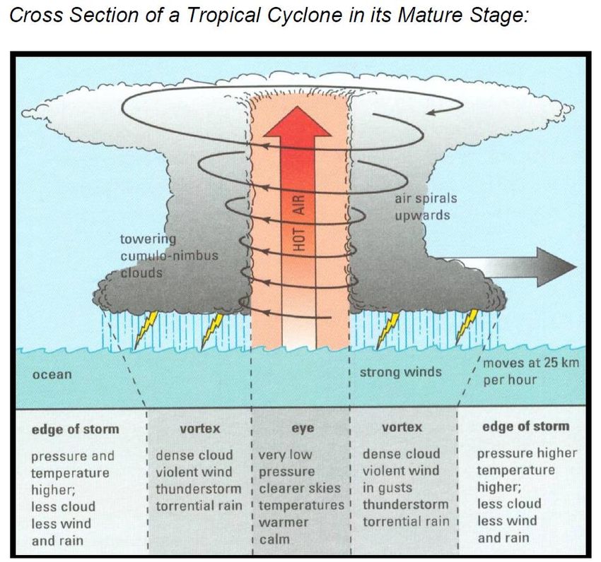
• Intense low-pressure systems that form over
                    warm tropical oceans with temperatures of at
                    least 26 degrees.
                  • They originate in late summer or autumn.
                  • They need Coriolis force to form, which is zero
                    within 5 degrees of the equator, so they
                    develop within latitudes of 5 and 20 degrees
                    North or South of the Equator.
Characteristics   • They move Westwards at a rate of 40-200 km a
                    day curving Eastwards.
                  • Because they are low pressure systems, they
                    rotate clockwise in SH, anti-clockwise in NH.
                  • Source of energy in tropical cyclones is the
                    latent heat released as warm, rising, moist
                    tropical air.
                  • Accompanied by heavy rain, storm surges and
                    high winds.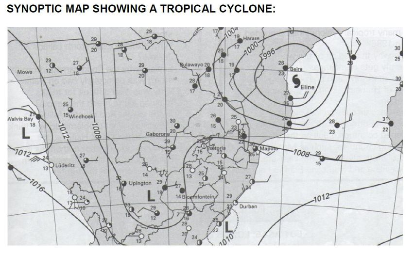
Hurricanes
                                  – North
                                  America
Tropical Cyclones
(Southern Africa /
Australia) - a.k.a
                      Willy-
                                              Typhoons -
                     Willies -
                                                 Asia
                     Australia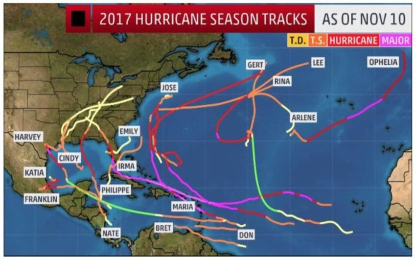
TROPICAL     CYCLONES
                               TROPICAL CYCLONES

                             CHARACTERISTICS
                                                          Equator/Ewenaar
                                                From EAST to WEST

                               EYE
                           No wind, rain
                             & Clouds

DESTRUCTION
•Storm winds
•Torrential rain
•Flooding

                                           DISSIPATES
              Turns EAST at 30°
                                           •No Moisture
                                           •No warm air
                                           •Friction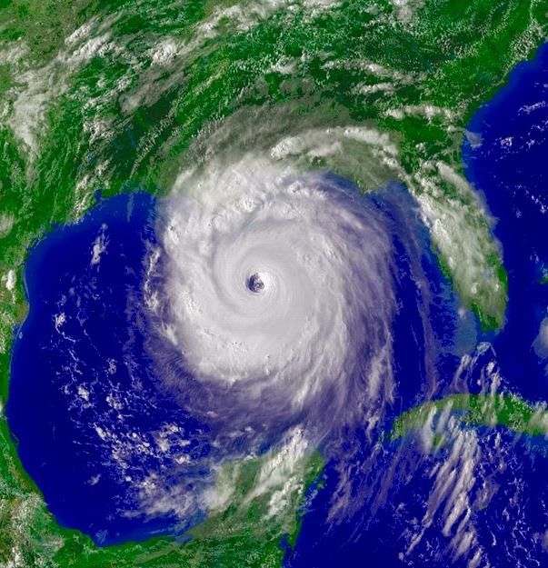
Potentially Devastating!

Cruise Ship
Capsized -
Typhoon
• Sea 26°C plus
                • High humidity
                • Unstable air
                • Very low pressure
Requirements      (steep pressure gradient)
for Formation   • Coriolis force
                  5°-25° N/S of equator
                • Strong upper air
                  divergence/Jet stream
                • Very little surface friction
Latent heat feeds the
storm with energy
• Latent heat releasedHurricane Names • Until World War II, hurricanes were given only masculine names. In the early 1950s, weather services began naming storms alphabetically and with only feminine names. By the late 1970s, this practice was replaced with alternating masculine and feminine names. The first hurricane of the season is given a name starting with the letter A, the second with the letter B and so on. –name given by weather station which identifies the formation of a tropical cyclone first
Hurricane Names continued

• Hurricanes in the Pacific Ocean are assigned a different set
  of names than Atlantic storms. For example, the first
  hurricane of the 2001 hurricane season was a Pacific
  Ocean storm near Acapulco, Mexico, named Adolf. The first
  Atlantic storm of the 2001 season would be named Allison.
Erratic Paths
A low pressure cell with closed isobars
              between 5˚ and 30˚ N and S of the
              Equator

How do you
recognise     Symbol for tropical cyclone in the eye
              (centre of low pressure)
tropical
cyclones on   Name of the tropical cyclone written next
synoptic      to the system

maps?
              Date of the map: late summer, early
              autumn
Tropical Cyclones on Synoptic Weather maps
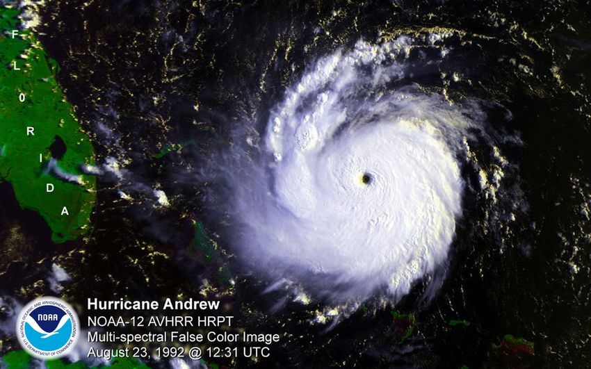
Satellite image ; Tropical
Cyclone east of Madagascar
Very strong
 winds in a
  tropical
  cyclone
Activity 4: Answers
•1a. The Chinese Sea; Japan and South-east Asia.
 Typhoons.
•B. Hurricanes: West Indies; Gulf of West Indies; Gulf
 of Mexico and USA.
•Tropical Cyclones: India; Madagascar; Mauritius;
 Mozambique, Australia.
•C. On the Equator the Coriolis force will be
 insufficient to enable the air to spin.
• 2a. 5° and 20° North and South
• B. Warm oceans: provide heat needed for convection; High
  humidity – latent heat is released during condensation; little
  surface friction – helps unhindered movement of air.
• C. Air rises along sides of eye: Warm moist air condenses and
  causes heavy rainfall over areas just below it.
• Air sinks in the centre of the eye: Air is relatively colder and has
  lower humidity, leading to no condensation, no clouds and no
  precipitation.
• D. At the surface: Air converges and rises, along the sides of the
  eye. In the upper air: Air diverges.
• Initial or Formative
Stages of     • Immature
Development   • Mature
              • Dissipates
Easterly wave Initial or Formative Stage
• LP system forms over sea
INITIAL
• Easterly wave deepens
pressure • Pressure drops to just above
ABOVE
1000 hPa
1000hPa
• Convergence and vortex
develops
• Light rain
• GalesImmature Stage
• Pressure below 1000hPa
IMMATURE
Pressure • Warm air continues to rise
BELOW
1 000 hPa • Weak upper air divergence
• Spiral bands and light rains
• Hurricane speed winds close
to eyeMature Stage
• Named
• Pressure in eye approx. 940hPa
MATURE • Cb Clouds, heavy rain
pressure
WELL • Strong upper air divergence
BELOW
1 000hPa • Air subsides in eye – warming
adiabatically
• Gales on edge, hurricanes near eye
• Dangerous semi circleDangerous Semi
Direction of movement
Circle
• The direction of winds within
the cyclone coincide with the
direction of the forward
movement of the entire
cyclone
• Front left hand quadrant in
Southern hemisphere = worst
weatherCross section through mature stage of TC
Simplified cross section through
        Tropical Cyclone
Dissipation/Degeneration
Stage
• Cut off from heat source e.g.
DISSI- moves into the higher latitudes
PATION
pressure
which is cooler
RISES • Cut off from moisture source
e.g. the system moves over
land – therefore has less latent
heat
• FrictionSUMMARY:TROPICAL CYCLONE: DEVELOPMENT
IMMATURE
INITIAL
Pressure
pressure
BELOW
ABOVE
1 000 hPa
1000 hPa
MATURE
pressure DISSI-
WELL PATION
BELOW pressure
1 000hPa RISESHurricane Sandy (New York) 2012
New York City MTA Chairman
Joseph J. Lhota released a
statement Tuesday declaring
Hurricane Sandy the most
“devastating” disaster in the
subway’s 108-year history. The
hurricane has flooded seven
subway tunnels under the East
River and affected “every
borough and county of the
region,” according to the
statement.Tropical Cyclone Debbie March 2017 Australia
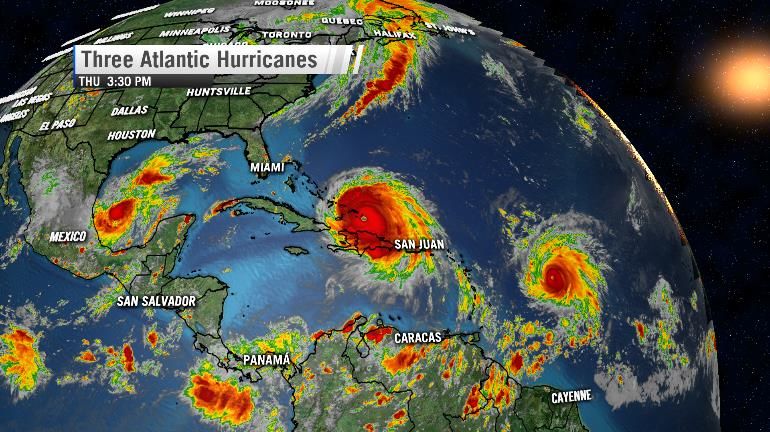
The 2017 Hurricane season - USA
Hurricane
paths 2017
   USA
Hurricanes January 2015 Indian Ocean
Activity 5: Answers
• 1) Eye. Air rises along walls of the eye and circulates anti-clockwise; in the centre
  the air sinks.
• 2) Northern hemisphere: the anti-clockwise upward circulation in the eye.
• 3) Cumulus clouds (called cumulonimbus clouds if rain falls from them). The high
  vertical extent is a consequence of the high temperature of the air, high humidity
  causing condensation as air rises.
• 4) Tropical storm (wind speeds between 61 and 117 km/h)
• 5) Air temperatures higher than 27°C; high humidity; unstable air; little surface
  friction; light variable winds; air pressure must be low with closed isobars;
  divergence of air at upper levels.
• 6) Over land areas, evaporation will be less, therefore less condensation and less
  latent heat will be released. There is also more friction over land, winds will
  become slower and Coriolis Force will be less.
Satellite images of tropical cyclones
The Eye
The Coriolis effect on the eye (3 minutes)
Walls of the Eye
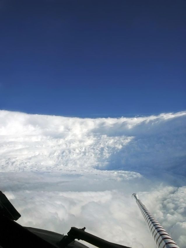
Time lapse video through the eye
• Air pressure decreases
                 • Sinking air
                 • Wind is calm (except sea may be
                   violent)
Weather in the   • Free of clouds
                 • Little, if any, rain
Eye
                 • At surface coldest part of storm
                 • At upper levels the warmest part of the
                   storm
                 • Storm surge on ocean
Weather in Eye
Activity 6: Answers
• 1) Number 6
• 2) Figure 51: Arrows indicating wind direction show clockwise
  circulation into the centre of the storm (eye); Figure 52: Cloud
  pattern shows clockwise inward movement to the eye –
  thinner clouds towards outside, but much denser cloud cover
  near the eye. Figure 53: The meteorological symbol indicates
  clockwise air circulation. The symbol for a tropical storm in the
  Southern Hemisphere is

• In the Northern hemisphere the symbol indicates anti-
  clockwise air circulation and look like this   (Notice the
  change in direction)
•3) Active quadrant.
•4) Developing stage: Air pressure in the centre (eye) falls
 below 1000 hPa; storm is still small in size; clockwise
 convergence of air continues; vortex contracts and storm
 intensifies; low-level air provides sensible heat and latent
 heat that is converted into kinetic energy; spiral bands of
 clouds and heavy rain; cumulonimbus clouds surround
 the eye, reaching heights of up to approx 12km; wind
 speeds within 50 km of eye and gales within 500 km of
 eye; tropical storm influences a large area, approx. 600
 km in diameter.
•5) Southern Mozambique, northern South Africa,
 Swaziland and also probably south-eastern parts of
 Zimbabwe. Possible weather and hazards; spiral
 bands of clouds; heavy rain and flooding; very
 strong winds; storm surges along coastal areas;
 destruction of infrastructure like roads and
 buildings.
•6) No cloud cover due to subsiding air; surrounded
 by very thin cloud cover of large vertical extent
 (cumulonimbus clouds); very high wind speeds in
 the eye.
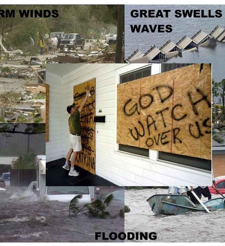
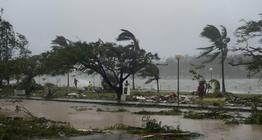
Impact of Tropical Cyclones (People and Land)
• The most destructive natural hazards in terms of frequency and
  number of deaths.
• Not only people, but also the natural and constructed environments
  are impacted.
• Cannot be controlled by us.
• Heavy rain, high wind velocity and low pressure are the three factors
  of destruction from cyclones.
• Video of Hurricane Katrina.
• Table 19 pg. 74.
Hurricane Katrina Day by Day (5 min 13 sec).
Peak frequency of in January and February
                    (Late Summer).

The Effect of       Only tropical cyclones moving into the
                    Mozambique channel influence South
Tropical Cyclones   Africa's weather, then…

on                  The Limpopo Province, Mpumalanga and
                    KwaZulu-Natal may experience destructive
South Africa        winds and the risk of flooding, and …

                    Dry weather over the interior because of the
                    subsiding air surrounding a tropical cyclone.
The Effect of Significant
tropical
Tropical Cyclones cyclones that
had such an
“Domoina”
“Imboa” in
February
“Eline” in
February
January 1984
on effect on
South Africa
1984 2000
was:
South AfricaResearch development and typical paths more
Research accurately
Better Better meteorological warning systems
Precautionary Don’t Don’t build below the flood line
strategies build
Have proper, well-practiced disaster management plans
Plans in place
Have a good warning system in place – buy-in from local
Warning radio stationsPreserve Preserve sand dunes and wetlands
Don’t build Don’t build right on the shoreline
Precautionary Strengthen Strengthen building structures
strategies
Flood Flood – proof homes
Limit the construction of infrastructure in hazard prone
Limit areasDisaster Management
4 ASPECTS TO A PROPER DISASTER
MANAGEMENT PLAN:
• Planning
• Evacuation after storm warning
• Emergency aid immediately after storm
• Restoration of communityTypical Exam Questions • Identify the feature – TC • Explain requirements for TC development • List typical features of the TC as evident on the synoptic chart • Identify dangerous quadrant/semi-circle AND explain the reason why it is the most dangerous – isobars tightly packed and the direction of airflow within the system coincides with the direction of travel of the entire system. • Identify the stage of development the Tropical Cyclone is in.
Typical Exam Questions
• Explain the wind direction at a certain weather station
• Draw cross section of mature stage
• Describe conditions in “the eye”
• Reasons for dissipation
• Relevance to SA
• How many cyclones before “Fred”?
• Explain the concept “recurvature”
• Environmental (human/nature) damage caused
• Precautions
EXAMINATION QUESTION

                                                                    •Coriolis force
Tropical                                                            •Warm water
easterlies
                                                                    •Moisture
                    •Land
                    •No warm
                    water
                    •Friction
 1   Give ONE similarity between Hurricanes and Tropical cyclones on the map.
 2   Explain the point of origin of both hurricanes and tropical cyclones on the map.
 3   Why do these cyclones move from east to west?
 4   Why do tropical cyclones weaken as they move over Madagascar.
 5   Why is the impact of tropical cyclones more severe in developing countries?
SUMMARY : TROPICAL CYCLONES
NAME MOVEMENT DESTRUC-
ORIGIN ➢From E na W TION
Alphabet
➢In tropics ➢Away from ➢Storm winds
➢Andrew
➢OCEANS ➢Very hard
➢Bonny Equator
➢Not nearer ➢Turns east
➢Carl rain
than 5° from ➢Flooding
➢Debora at 30°
equator
IN EYE DISSIPA- MANAGED
WEATHER
No : TION ➢Sand bags
➢Wind Over land ➢Early warning
➢Before eye
➢Clouds ➢No Moisture ➢Track storm
➢During eye
➢Rain ➢No Warm air ➢Services
➢After eye
➢Friction ➢Inform people
➢EvacuationCase Study 2: Answers •1) 9 days from 26 February (leap year) to 5 March 2012. Look at diagram not at content. •2) Sea surface temperatures were high over the ocean, 29-31°C. Warm, moist air flowed into the system. •Condensation with the rise of the air released latent energy, this provided the main source of energy that drove the tropical system. •3) Deaths: 142 people
•4) Well-organised communication
 between weather organisations
 like the South African Weather
 Services and reaching all people
 via radio, TV and local government
 structures.
Unit 2 Questions: Answers
•1a) Anti-clockwise
•B) Vortex
•C) ITCZ
•D) The speed of circulation and forward motion.
•E) Typhoons
•2a) Fifth
•B) Symbol and name of tropical cyclone Eline.
• C) Beira – no wind in the eye.
• Weather station south of Beira – easterly wind of 20 knots, strong clockwise
  circulation of air around the eye.
• D) Immature stage: Air pressure in the eye fell below 1000hPa but has not
  reached a lowest point about 900-940hPa or lower.
• E)
  Weather Element            Maputo                    Luderitz
  Air temperature            30°C                      24°C
  Dew point temperature 25°C                           13°C
  Cloud cover                3/4                       No cloud cover
  Wind direction             East South-east           North-West
  Wind speed                 15 knots                  35 knots
  Weather                    Fair                      Fair
• F) Coastal low pressure, moving around South African coastline from
  Namibian coast to the east coast of SA.
• 3a) Cuba, the Bahamas, Gulf of West Indies.
• B) Indication of Cuba and Florida which are situated north of the
  equator, air is circulating anti-clockwise around the low-pressure
  system or the eye.
• C) Air temperature higher than 26°C, high humidity, unstable air, little
  surface friction, light variable winds, air pressure must be low with
  closed isobars, divergence of air at upper levels.
• D) North-westerly direction
• E) On 9 august: temperatures begin to fall, air pressure begins to fall,
  winds are gentle from the north-west, winds begin to gust (gale force
  winds 100km/h), clouds begin to form, cumulonimbus clouds with
  thunder form, showers develop.
•On 10 August: period of calm (eye), no
 wind, air pressure very low (at lowest),
 temperature rises, as Sun makes brief
 appearance (no clouds), no rain.
•On 11 August: storm onslaught begins
 again, gale force winds of up to 160km/h,
 winds now south-easterly, torrential rain,
 temperatures drop again but rise later, air
 pressure begins to rise, later rain and
 wind decreases.
You can also read