Lavaca County Situation Awareness Brief - Monday, July 19, 2021 as of 1430 CST
←
→
Page content transcription
If your browser does not render page correctly, please read the page content below
Lavaca County Situation Awareness Brief
    Monday, July 19, 2021 as of 1430 CST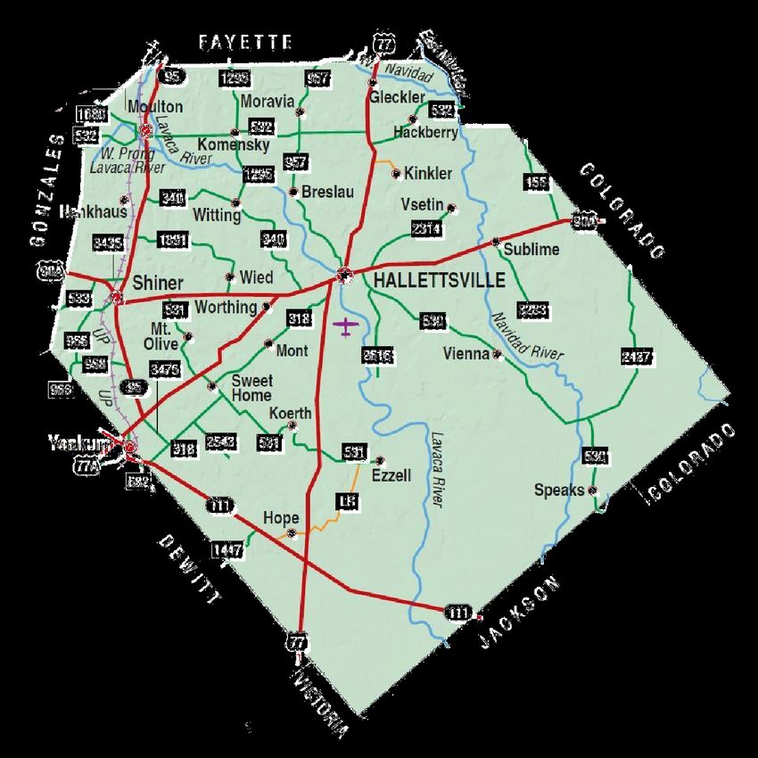
Lavaca County OEM

OPERATIONAL PRIORITIES:

1. Protect life and property.
2. Support rapid & effective response.
3. Collect and disseminate accurate incident information to improve decision making.
4. Accurately track incident costs associated with assigned resources for
cost recovery.

Lavaca County Emergency Operations Center (EOC) is at Level IV
(Normal Conditions).

The four levels of activation are:

Level   I (Emergency Conditions)
Level   II (Escalated Response Conditions)
Level   III(Increased Readiness Conditions)
Level   IV (Normal Conditions)
Incidents Reported to Lavaca OEM
         (last 48 hours)
       DATE         SUBJECT               LOCATION                     Final
                                                                      Report
                                                                       (Y/N)
07/17/2021    Police Chase & Bailout   Lavaca County Road       YES
                                       123G

07/18/2021    Motor Vehicle Accident   Lavaca County Road 214   YES

07/18/2021    One Male Subject with    Lavaca County Road       YES
              Gunshot Wound.           157-A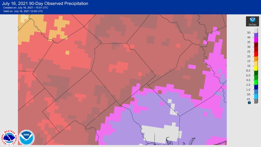
Informational Products
       Distributed by Lavaca OEM
  DATE                                      SUBJECT

07/16/2021   Golden Crescent Regional Planning Commission Tire Collection Event
             Cancellation
07/16/2021   Lavaca County Road and Bridge progress
07/16/2021   National Weather Service Austin San Antonio 90 day rainfall total map
07/16/2021   Traffic Advisory - MORAVIA - Ascension of Our Lord Parish Picnic
07/17/2021   Traffic Advisory – SHINER - Downtown Market Day
07/17/2021   HEAT INDEX VALUES BETWEEN 105 AND 109 DEGREES EXPECTED
07/17/2021   CodeRED Activation - Police Chase & Bailout
07/18/2021   SHINER - Disabled 18-Wheeler on SH95.
07/19/2021   Hazardous Weather Outlook for Lavaca County
07/19/2021   HEAT INDEX VALUES BETWEEN 105 AND 109 EXPECTED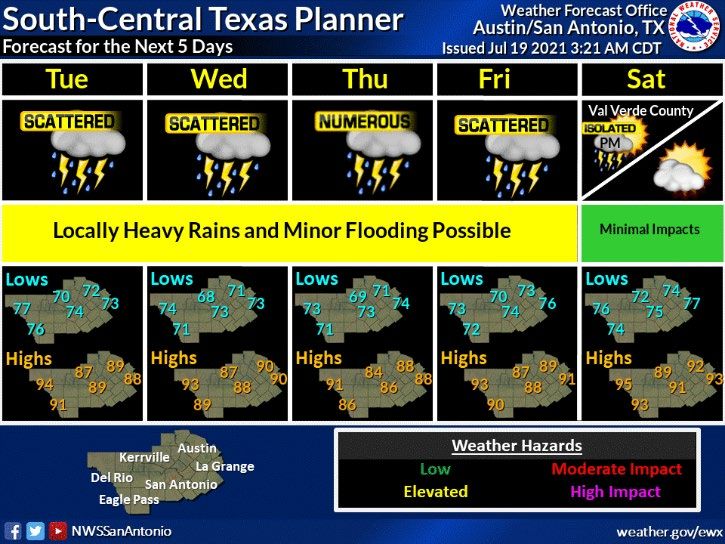
COVID-19 Case Overview - July 19, 2021; 1000
NEW INFORMATION: GCMOC reports a significant increase in COVID+ patients in the
region with a large increase this weekend.

 DSHS Public        Confirmed           Active           Recovered           Deaths
   Health                                                  Total
  Region 8

  Lavaca             2,039               16               2,448               61
  County              +10                +13                +5                0
   Golden           Confirmed           Active          Recovered           Deaths
  Crescent                                                Total
   Region

                     17, 414             168              18,272              392
                      +105               +63               +60                 0
Lavaca County OEM COVID-19 Response

The Texas Department of State Health Services is
beginning to transition back into normal operations,
and weekly COVID-19 County Reports will be
discontinued. Case counts can still be obtained from
the statewide dashboard here.

With COVID-19 vaccines now widely available and
new infections and hospitalizations down significantly,
this information no longer provides the benefit it did
during the height of the pandemic.

Additional information on the COVID-19 Response
may be obtained on the Department of State Health
Services - Public Health Region 8 - COVID-19
Website.
Hazardous Weather

90-Day Observed Precipitation
At the request of Lavaca County OEM, the National Weather Service in Austin San Antonio has provided this 90 day
rainfall total map to share with you. The map uses radar estimates, but corrects it with known gauge data and
considered a really good guess and estimate. Paul Yura with NWS Austin San Antonio reports that a CoCoRaHS
gauge in the south part of the county has recorded over 30 inches of rainfall since May 1st.
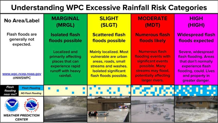
Hazardous Weather
There is the potential for strong to marginally severe thunderstorms this
afternoon and evening as a cold front and outflow boundaries push across
the northeast and east parts of South Central Texas. Strong to damaging
thunderstorm winds are the main threat.
Hazardous Weather
This Hazardous Weather Outlook is for South-Central Texas..

.DAY ONE...Today And Tonight.

Locally heavy rainfall and isolated minor flash flooding may be
possible from this afternoon into tonight with scattered to
numerous showers and thunderstorms associated with a rare July
front moving into and across the region. Some of these storms
could be strong to marginally severe with thunderstorm damaging
winds being the main threat.

.DAYS TWO THROUGH SEVEN...Tuesday through Sunday.

Wet pattern continues with scattered to numerous showers and
thunderstorms from Tuesday through Friday. In addition to cloud-
to-ground lightning, locally heavy rainfall and minor flash
flooding may be possible.

.SPOTTER INFORMATION STATEMENT...

Spotters are encouraged to report any flooding to the National
Weather Service. Learn more about the #eWXspotter program at
https://www.weather.gov/ewx/vost
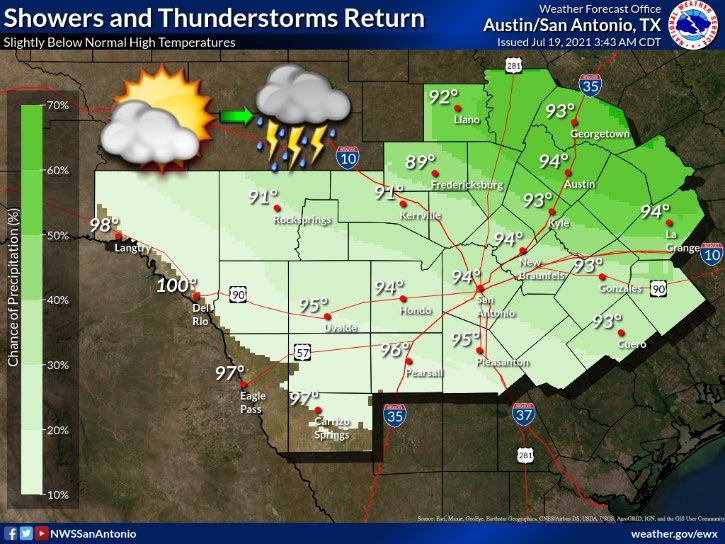
Lavaca County Area Weather
A rare Mid-Summer cold front brings a return of chances of showers and
thunderstorms midday into this afternoon. Locally heavy rains and minor
flooding are possible. Slightly below normal high temperatures continue.
Lavaca County Area Weather
An upper level disturbance brings rounds of showers and thunderstorms
Tuesday through Friday. Locally heavy rains and minor flooding are possible.
The disturbance moves west of our area Saturday with a slight chance of
afternoon showers and thunderstorms only over Val Verde County.
Temperatures will average below normal for the next several days.
Lavaca County Weather Forecast
Tonight: Showers and thunderstorms. Lows in the mid 70s. Southeast winds 5 to 10
mph, becoming west after midnight. Chance of rain 80 percent.

Tuesday: Partly cloudy with a chance of showers and thunderstorms. Highs around 90.
North winds 10 to 15 mph. Chance of rain 50 percent.

Tuesday Night: Partly cloudy. A slight chance of showers and thunderstorms before
midnight, then a chance of showers and thunderstorms after midnight. Lows in the
lower 70s. North winds 5 to 10 mph. Chance of rain 40 percent.

Wednesday: Partly cloudy. A slight chance of showers and thunderstorms in the
morning, then a chance of showers and thunderstorms in the afternoon. Highs around
90. North winds 5 to 10 mph, becoming east in the afternoon. Chance of rain 50
percent.

Wednesday Night: Partly cloudy. A slight chance of showers and thunderstorms after
midnight. Lows in the mid 70s. South winds 5 to 10 mph. Chance of rain 20 percent.

Thursday: Partly cloudy with a chance of showers and thunderstorms in the morning,
then mostly cloudy with showers and thunderstorms likely in the afternoon. Highs in
the upper 80s. Chance of rain 70 percent.

Thursday Night: Partly cloudy. A slight chance of showers and thunderstorms after
midnight. Lows in the mid 70s. Chance of rain 20 percent.
Tropical Weather Awareness
Monitoring the Tropics - Discussion
Tropical Weather Outlook
NWS National Hurricane Center Miami FL
200 PM EDT Mon Jul 19 2021

For the North Atlantic...Caribbean Sea and the Gulf of Mexico:

Tropical cyclone formation is not expected during the next 5 days.
Lavaca County Burn Ban Status & KBDI Summary

      KBDI    Min   Max   Average   Change
    Summary

     Lavaca   79    222    130       +19
KEETCH-BYRAM DROUGHT INDEX
Lavaca County Fire Danger
                    Lavaca County
                  Fire Danger Level:

                    LOW (GREEN)

                     When the fire
                   danger is low it
                  means that fuels
                      do not ignite
                  easily from small
                    embers, but a
                  more intense heat
                   source, such as
                    lightning, may
                  start fires in duff
                     or dry, rotten
                         wood.
Lavaca County Fire Weather
An upper level disturbance will drift to the west over our area this week. A cold front will also move into our area
into tonight, then dissipate Wednesday. These features along with heating will maintain chances of wetting rains
from multiple rounds of showers and thunderstorms tonight through Friday. Locally heavy rain is possible. Upper
level ridging will build over our area next weekend keeping us rain-free, except a few afternoon showers and
thunderstorms are possible over Val Verde county. Minimum relative humidities will remain elevated.
Karnes-De Witt-Lavaca-
Including the cities of Karnes City, Cuero, and Hallettsville
226 PM CDT Mon Jul 19 2021
Tonight Tue Tue Night Wed
Cloud cover Pcldy Pcldy Pcldy Pcldy
Chance precip (%) 70 50 30 40
Precip Type Tstms Tstms Tstms Tstms
Temp (24h trend) 74 (-1) 90 (-4) 72 90
RH % (24h trend) 93 (-7) 56 (+10) 94 55
20ftWnd-AM(MPH) NW 10 N 6
20ftWnd-PM(MPH) SE 11 N 12 NE 11 E 8
Mixing hgt(ft-AGL) 4635 4810
Transport wnd (MPH) NE 13 NE 5
CWR 30 30 0 10
LAL 4 4 4 3
Haines Index 3 3 3 3
Remarks...None.Lavaca County Air Quality Index Forecast Region (Click name for Mon Tue Wed Thu AIRNOW version) 07/19/2021 07/20/2021 07/21/2021 07/22/2021 Victoria Good Good Good Good This forecast was last updated at 11:05 AM on Monday, July 19th, and is updated daily on normal TCEQ work days and may also be updated on weekends or holidays when air pollution levels are high. Regardless of our forecast, we always recommend that each individual determine what level of activity they should conduct based on the actual local conditions.
Lavaca County Air Quality Index
Monday 07/19/2021
Increased cloud cover with areas of isolated precipitation, and/or lower incoming background levels should help
keep air quality in the "Good" range in most spots.

Tuesday 07/20/2021
Moderate winds, heavier cloud cover with areas of isolated to scattered precipitation, and/or lower incoming
background levels should help keep air quality in the "Good" range in most spots.

Wednesday 07/21/2021 Outlook
Increased fine particulate levels associated with a combination of filtering smoke from wildfire activity in the Pacific
Northwest and building continental haze behind a weakening stalled frontal boundary could eventually impact
portions of the state North of a line from Laredo to Corpus Christi and raise the daily PM2.5 AQI to the upper end of
the "Good" range (perhaps with an isolated low "Moderate" or two) in parts of the Laredo and Victoria areas.

Otherwise and elsewhere across South Texas, increased cloud cover with isolated precipitation, and/or lower
incoming background levels should help keep air quality in the "Good" range in most spots.

Thursday 07/22/2021 Outlook
Decreasing cloud cover, and/or lower incoming background levels should help keep air quality in the "Good" range
in most spots.
Drought Monitor Austin – San Antonio WFO
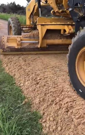
Lavaca County Road & Bridge
As you have seen from our last Facebook Post, Lavaca
County has received 20" to 40" of rainfall since May 1,
2021.

Since then, many County Roads have damage including
but not limited to washout, and culvert damage.

Lavaca County OEM would like you to know that the
County Road and Bridge departments, weather
permitting, are working as fast and safe as possible to
make repairs on these damaged roads.

Thank you for reporting road damage to your County
Commissioners office and for your patience as crews
continue to make repairs.

Lavaca County OEM urges you to please use extra
caution while traveling on Lavaca County Roads during
this time.
Lavaca County Cone Zone Closures
This is a partial list of reported road/street closures as reported by State, County, and
Local Municipalities, to Lavaca County OEM.

TXDOT – Lavaca County
No Reported road closures

THE CITY OF HALLETTSVILLE -
No Reported street closures

THE CITY OF MOULTON -
No Reported street closures

THE CITY OF SHINER -
No Reported street closures

THE CITY OF YOAKUM -
No reported street closures

Lavaca County –
Lavaca County Road 16-A
Lavaca County Road 462
Lavaca County Road 395 from LCR 392 to culvert replacement site.
On 7/20/2021, Lavaca County Road 256 will be CLOSED.
Lavaca County Significant Events
               DATE(S)                 LOCATION                EVENT
  07/23/2021             07/25/2021    MOULTON         Moulton Town & Country
                                                              Jamboree
  07/31/2021             07/31/2021      SHINER       Pivo and Kolaches 0.5k Fun
  08/19/2021             08/19/2021   HALLETTSVILLE   LOUISE VS SACRED HEART
  08/27/2021             08/27/2021   HALLETTSVILLE   SHINER VS HALLETTSVILLE

  08/27/2021             08/27/2021      SHINER       YORKTOWN VS SAINT PAUL
  09/03/2021             09/03/2021      SHINER          BLANCO VS SHINER
  09/03/2021             09/03/2021   HALLETTSVILLE    ROSEHILL CHRISTIAN VS
                                                           SACRED HEART
  09/03/2021             09/03/2021     YOAKUM         SMITHVILLE VS YOAKUM
  09/10/2021             09/10/2021      SHINER       SA DAVENPORT VS SHINER
  09/10/2021             09/10/2021   HALLETTSVILLE   GANADO VS HALLETTSVILLE

  09/17/2021             09/17/2021      SHINER         TBD VS SAINT PAUL
  09/17/2021             09/17/2021     YOAKUM         NEEDVILLE VS YOAKUM
  09/24/2021             09/24/2021      SHINER         BURTON VS SHINER
  09/24/2021             09/24/2021   HALLETTSVILLE      SCHULENBURG VS
                                                          HALLETTSVILLE
  09/25/2021             09/25/2021   HALLETTSVILLE       HALLETTSVILLE
                                                           KOLACHE FEST
***DUE TO A
SCHEDULING CONFLICT,
THE DATE FOR THIS
TRAINING HAS BEEN
CHANGED***
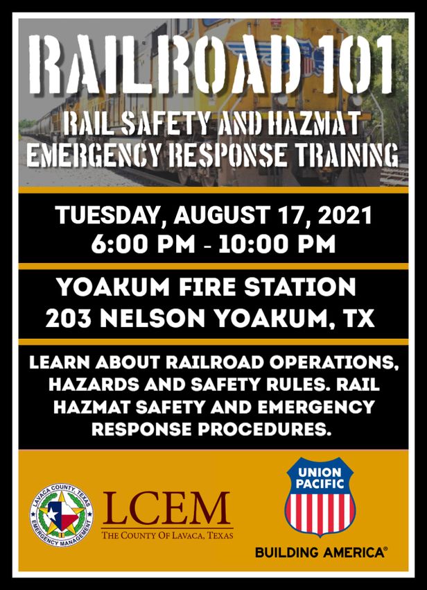
Lavaca County OEM has secured training
from TRANSCAER, and Union Pacific
Railroad, and will be bringing the
RAILROAD 101 class to the Yoakum Fire
Station, 203 Nelson Street, Yoakum,
Texas 77995 one August 17, 2021 from
6 until 10 PM.
The program will provide information
about railroad operations, hazards and
safety rules, Rail Hazmat safety, and
emergency response procedures.
Refreshments, copies of training
materials, & certificate of completion will
be provided after the event.
Please RSVP to
eoc@co.lavaca.tx.us by
August 1, 2021.Flipping OFF the Switch on HOT Emergency Medical Vehicle Responses
It continues to be all of our goals to have a safe EMS system for the patients we treat and transport and our
dedicated workforce, to this end PLEASE take the time to view the webinar below and share with your membership.
A special thanks to Matt Zavadsky for making this webinar available for all of us to learn from!
Thank You,
Joseph W. Schmider,
State EMS Director
How many people are injured or killed during a HOT response by EMS
vehicles?
How many EMS providers have been injured or killed during a HOT
response?
Is there any difference in patient outcomes from a HOT or COLD response?
What REALLY is the public's expectation when it comes to HOT responses?
What are the things that are preventing people from calling 911 for EMS
(hint - it's the 'spectacle' it creates)?
Get the answers to those questions and more!
http://aimhi.mobi/ondemand/10737263You can also read