UNITEC REFERENCE PLAN & STRATEGIC FRAMEWORK - JUNE 2020
←
→
Page content transcription
If your browser does not render page correctly, please read the page content below
UNITEC REFERENCE PLAN & STRATEGIC FRAMEWORK
                  JUNE 2020
NGĀ TĀTOU MATAPONO – SHARED PRINCIPLES
VISION
He hononga tika ki te hangai ngā hapori toitū me he tāone taioreore mai
ngā auahatanga me ngā ahurea taukiri o te hapori
A true partnership to establish inclusive sustainable communities and
world class city building through vibrant and innovative place-making.
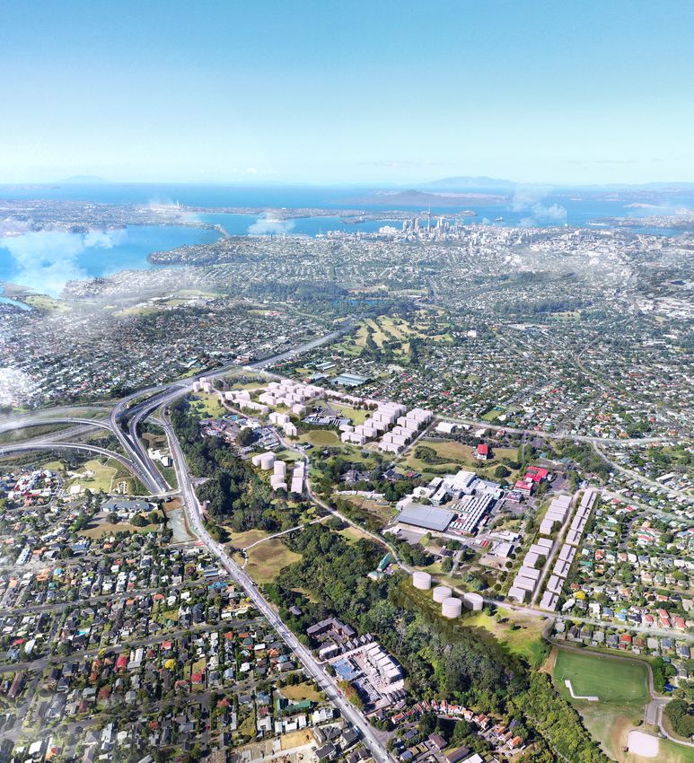
THE SITE
The Site has visual connections to the Tūpuna Maunga of Ōwairaka and Maungawhau,
as well as to Rangitoto. The headwaters of Te Auaunga (Oakley) Creek spring just
above the Manukau Harbour, and flow past the site into the Waitematā. A tributary
waterway, the Wairaka Stream, flows from the puna within the Unitec campus before
joining Te Auaunga. The site contains a number of important heritage, historical and
archaeological features, large established trees and the former Carrington Hospital on
its Northern vantage point.
The Site is located 8 kilometres from the Auckland city centre, and at its full extent may
be the single largest contiguous ‘brownfields’ development in New Zealand. The Crown
owns or controls approximately 50 hectares of land at the site, including the Unitec
Campus (24 hectares). The site connects to both the communities of Pt Chevalier and
Mt Albert. It is proximate to excellent transport connections, including the Mt Albert and
Baldwin Avenue railway stations, multiple bus routes, the NW-Cycleway, Waterview
Tunnel and motorways North, West, and East.
ARTIST’S PERSPECTIVE AERIAL OBLIQUE OF THE SITE
UNITEC REFERENCE PLAN & STRATEGIC FRAMEWORK - JUNE 2020
1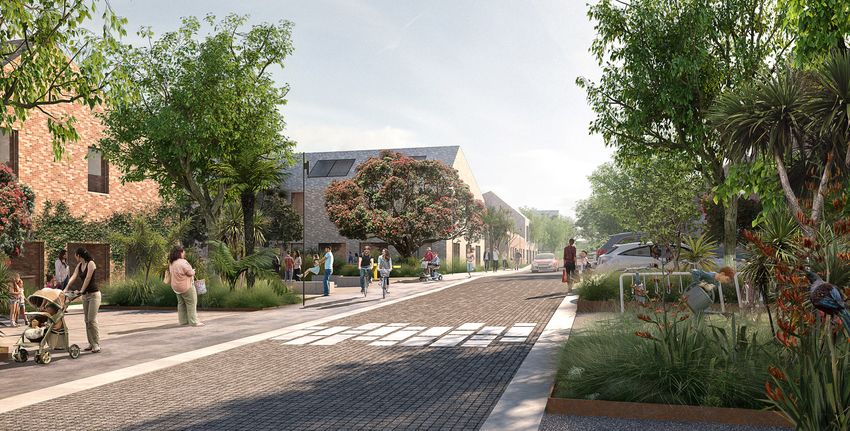
NGĀ WHAKAWHANAKE WHĀNUI – DEVELOPMENT OVERVIEW
KEY METRICS
Key
The site development starts with 26.5 hectares of land which are the core- Boundary
landholdings, with an additional 9.3 hectares under negotiation. Existing Building
Existing Building to be retained
The base plan is fully compliant with the Auckland Unitary Plan. It delivers: Heritage
Proposed Buildings
• 11.3 hectares (41%) of open space (including road reserves) Proposed Parking Buildings
• 12.3 ha of developable land Roading
Road Reserve
• ~ 2,500 – 3,000 dwellings across nine Precincts (individual Existing bridge
neighbourhoods) Main access
• building heights of between 2 stories in the South rising to 8 stories in
Secondary access
Parking building access
the centre and North On-street Parking
• density of between 94 and 113 dwellings per hectare gross or 204 per Pathway / terrace
hectare net Open space for events
Private open space
• a ratio of 0.95 carparks to each dwelling Public open space
Wetlands
The overall project is estimated to take 10 – 15 years to complete. Waterways
Protected trees
Existing trees
WHAKAMATUATANGA – STAGING
Proposed trees
Precinct 1 trees
Precinct 3 trees
• The provisional sequencing of the Precinct stages is: Precinct 4 trees
> Southern Precinct 5 trees
Precinct 6&7 trees
> Carrington Road along the road frontage and east of Taylor’s Precinct 8 trees
Precinct 9 trees
> Northern and North-Western Precincts Precinct 10 trees
> Internal stages of Northern and Carrington Road Precincts Community gardens
> Te Auaunga North and South Precincts
• Site activation will also begin, including investment in the public realm.
This includes projects such as the enhancement of the Te Auaunga
frontage, Wairaka Stream daylighting, the building of cycleways and
other pathways through the Site and restoration and adaptive re-use of
historic buildings.
500
NGĀ HUA - DEVELOPMENT STRUCTURE
The Crown and Mana Whenua will build upon their existing partnership
models to establish a Rōpū development structure for the project. The
development structure will recognise the development rights Ngā Mana
Whenua o Tāmaki Makaurau have to the site. The Crown’s involvement
will be about making a fair contribution to achieve public good outcomes
250
across the site.
200
150
100
50
0
MBIE UNITEC MASTERPLAN MASTERPLAN ITERATION_F&B BLOCKS + TAYLOR’S LAUNDRY 22-01-19 1 : 5000 @ A3
UNITEC REFERENCE PLAN & STRATEGIC FRAMEWORK - JUNE 2020
2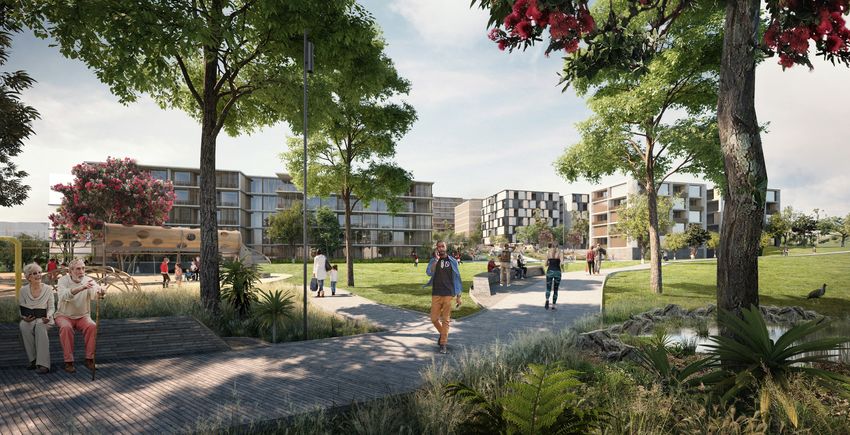
NGĀ TAPUAE MĀTUA – KEY STRUCTURING MOVES

PROJECT STATEMENT                                                              PUBLIC OPEN SPACE                                                                COMMUNITY ASSETS
Mana Whenua and the Crown partnering to deliver a Tāmaki Makaurau              •   Create a generous provision of interconnected, prominent open space          •   Build sustainable infrastructure: collect, reuse, recycle; solar
scale urban village.                                                               setting with the amenity necessary to support the new community and              generation; energy efficient buildings, energy and water harvesting /
                                                                                   its residential neighbours.                                                      storing / redistribution.
Combining the ancient and modern worlds.                                       •   Build on the natural assets of the site, including opening up and            •   Implement a strategy that reduces the impact of cars and carparking
                                                                                   daylighting the Wairaka Stream.                                                  over time, including carparking buildings that can be re-purposed
Creating inclusive communities with a range of housing typologies, tenure                                                                                           for commercial and / or residential use, shared parking with Unitec,
and pricing options in a medium to high density living environment.            •   Enhance a significant green corridor linking Carrington Road to Te
                                                                                                                                                                    charging stations for e-vehicles, pool cars.
                                                                                   Auaunga with multiple East / West connections.
An ambitious, long term project that will grow over time to influence and                                                                                       •   Promote carbon neutrality.
                                                                               •   Celebrate water in the landscape – reinforce the Wairaka and
reflect a changing Auckland.                                                       Te Auaunga waterways, and incorporate design that makes the                  •   Consider a new primary school.
                                                                                   stormwater capture, conveyance, treatment and re-use visible.
                                                                                                                                                                •   Collaborate with Unitec for continued learning, skill development,
                                                                               •   Improve existing recreation areas for informal sport, and build new              shared knowledge and learning laboratories.
The urban development on the site will honour its cultural heritage,               places for family kick-a-ball and games, imaginative play, multi-age,
                                                                                                                                                                •   Use the synergy between the construction to create training and skill
including its history as a place of gardening and gathering. It will enhance       accessible playgrounds, and for residents to gather, cook and eat.
                                                                                                                                                                    development opportunities.
the connection between the land and Te Auaunga, daylight and restore           •   Enhance the site’s bio-diversity and grow seasonally responsive
the Wairaka Stream. Place-making will enable the communities and                                                                                                •   Trial, evaluate and champion new technologies.
                                                                                   habitat / plantings. Preserve significant trees.
public to experience the natural character of the site alongside distinct
neighbourhoods. The site has the scale to bring together amenity,              •   Protect features that will provide continuity during the transition of the
connectivity and density in a new urban form. It will support a thriving,          site into an urban village.
                                                                                                                                                                PAPAKĀINGA – RESIDENTIAL DEVELOPMENT
mixed community that lives close to schools, continued learning, work
and recreation, and can connect to its neighbourhood and the city through                                                                                       •   Development that fits with the landform / topography.
multiple modes of transport. The Key Structuring Moves will help achieve       CONNECTIVITY                                                                     •   Areas that are able to be independently staged while cohesive as a
the vision for the development.
                                                                                                                                                                    whole.
                                                                               •   Strengthen / enhance and establish new, predominantly pedestrian
                                                                                   and cycleway connections to the site from the surrounding open space,        •   Individual neighbourhoods with distinct scale, intensity and identity.
                                                                                   neighbourhoods and town centres.
HERITAGE AND IDENTITY                                                                                                                                           •   Commercially viable and feasible.
                                                                               •   Significantly improve the nature and quality of the pedestrian and cycle
                                                                                                                                                                •   Scope to match development to market cycles. Mixed housing (public,
•   Enrich the new communities with tangible connections to the past               linkages, for example through a new overbridge or dedicated pathway
                                                                                                                                                                    affordable and market).
    including through retention of key buildings, trees and fragments of           to Pt Chevalier, reinforcing the new identity of the site.
    the site’s history.
                                                                               •   Create a fine grain of internal site connections to establish a
•   Refurbish the Carrington Hospital building for community / commercial          predominance of pedestrian and car alternative modes, including
    activities and create a new public open space reinvigorated with native        walking and running tracks, routes for bicycles and alternative low-
    planting as its distinctive setting.                                           speed modes across site.
•   Retain the Carrington Hospital, Pump House, Stables and associated         •   Support improved public transport including Carrington Road busway,
    Courtyard building as distinctive place-based accents / markers within         new (north and south bound) bus stops and connections to mass transit
    the new community.                                                             mobility networks.
•   Create strong statement entrances into the site: Waharoa, including        •   Retain and improve the site’s four current access points, including by
    installing prominent site markers between Carrington Hospital and its          reconfiguring the ‘Gate 1’ entrance.
    northern frontage to Pt Chevalier and the Northwestern Motorway – to
                                                                               •   Retain separation between car traffic from the South, and the site and
    create a landmark to define the new community.
                                                                                   Unitec campus.
•   Plant common gardens with edible produce for residents and the
    community.

                                                                                           UNITEC REFERENCE PLAN & STRATEGIC FRAMEWORK - JUNE 2020
                                                                                                                     3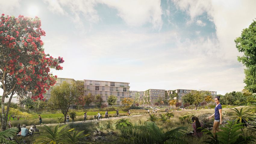
HE KARAPA O NGĀ HAPORI – PRECINCTS AT A GLANCE

                       ARTIST’S PERSPECTIVE: AERIAL OBLIQUE LOOKING ALONG CARRINGTON ROAD TO THE NORTHERN PRECINCT, CARRINGTON HOSPITAL PARKLAND AND ADAPTIVE RE-USE

                                     CARRINGTON HOSPITAL PRECINCT                                              NORTH WESTERN PRECINCT
                                     •   Adaptive re-use of Carrington Hospital, such as shared offices with   •   High intensity (but small building footprints).
                                         flexible tenancies creative technologies, common spaces and public
                                                                                                               •   Landmark residential towers with outlook to the central city and harbour.
                                         access.
                                                                                                               •   Māori architectural references / identity.
                                     •   Set within public open space parkland.
                                                                                                               •   8 - 10 storeys located and scaled in respect of views to Tūpuna Maunga.
                                     •   Improve cycle and pedestrian linkages, including an enhanced
                                         connection to Pt Chevalier.                                           •   Site development relative to trees and Carrington Hospital context.
                                                                                                               •   Buffer at lower levels to Mason Clinic.

                                                UNITEC REFERENCE PLAN & STRATEGIC FRAMEWORK - JUNE 2020
                                                                          4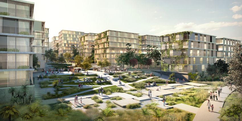
HE KARAPA O NGĀ HAPORI – PRECINCTS AT A GLANCE

                                       ARTIST’S PERSPECTIVE: WAIRAKA STREAM AND PARKLAND OPEN SPACE LOOKING TOWARD WESTERN SIDE OF CARRINGTON ROAD PRECINCT

                              NORTHERN PRECINCT                                                         TE AUAUNGA PRECINCTS
                             •   Medium intensity (100 dwellings per hectare).                          NORTH AND SOUTH
                             •   Varied typology and scale of footprint creating diversity and choice   •   Medium density, 4 - 6 storey buildings (100 dwellings per hectare).
                                 (options for development and living).                                  •   Architecture signals a sustainable, environmentally progressive urban
                             •   3 to 6 storeys.                                                            community.
                             •   Shared courtyards.                                                     •   Heights that respect and respond to the Volcanic Viewshaft and
                                                                                                            predominance of the Tūpuna Maunga.
                             •   Significant trees preserved.
                                                                                                        •   Community gardens and a strong connection to water.
                             •   Buffer to Mason Clinic.
                                                                                                        •   Connected both to Te Auaunga and the central parkland.
                             •   Connect to Carrington Hospital Precinct.

                                         UNITEC REFERENCE PLAN & STRATEGIC FRAMEWORK - JUNE 2020
                                                                   5
HE KARAPA O NGĀ HAPORI – PRECINCTS AT A GLANCE
ARTIST’S PERSPECTIVE: CARRINGTON ROAD PRECINCT
CARRINGTON ROAD PRECINCT
• Medium-high intensity (120 to 150 dwellings per hectare). • East / West open space connections from Carrington Road to the
central open space and Te Auaunga.
• 4 to 12 stories, starting at 4 to 8 and increasing East to West with falling
topography. • Pedestrian prioritised central North / South street.
• Varied frontages along Carrington Road on East (mid-heights). • Mixed use residential and commercial / retail adjacent to vibrant activity
centre in the South, scaled to support the local community.
• Stepped down westwards toward the central lower basin and open
space corridor.
UNITEC REFERENCE PLAN & STRATEGIC FRAMEWORK - JUNE 2020
6HE KARAPA O NGĀ HAPORI – PRECINCTS AT A GLANCE
ARTIST’S PERSPECTIVE: SOUTHERN PRECINCT LOOKING EAST ALONG THE CENTRAL STREET
SOUTHERN PRECINCT
• Complementary to existing residential neighbourhood.
• Low to medium density, 2 to 5 storeys (50 to 80 dwellings per hectare).
• A suburban transition, with finely grained streets and pedestrian
connections.
• Small blocks and lower density at the boundary grading to medium
density.
• Transport connections controlled – no access to Campus.
UNITEC REFERENCE PLAN & STRATEGIC FRAMEWORK - JUNE 2020
7You can also read