ASE An Archaeological Watching Brief at St Peter & St Paul Church, Gravesend Kent - Kent Archaeological Society
←
→
Page content transcription
If your browser does not render page correctly, please read the page content below
Archaeology South-East

                                               ASE
                 An Archaeological Watching Brief at
                     St Peter & St Paul Church,
                             Gravesend
                                Kent

                         NGR: TQ 65861 73838

                             Jake Wilson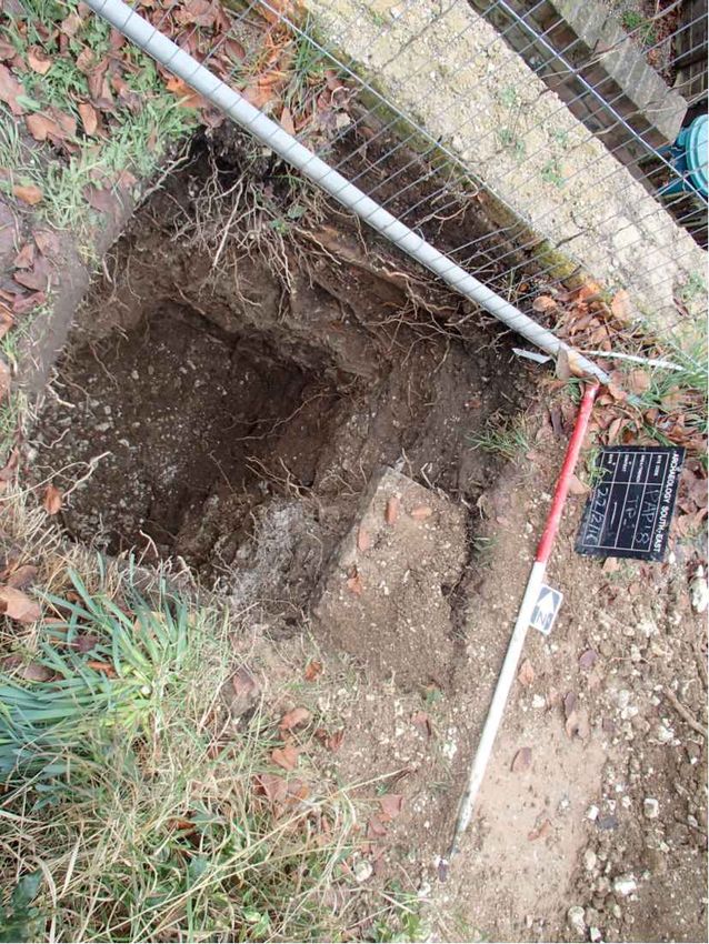
An Archaeological Watching Brief at
                     St Peter & St Paul Church,
                             Gravesend
                                Kent.

                          NGR: TQ 65861 73838

                         ASE Project No: 171209
                           Site Code: PAP18

                        ASE Report No: 2018078
                       OASIS id: archaeol6-312015

                                Jake Wilson

                    Illustrations by Naomi Humphreys

Prepared by:      Jake Wilson             Archaeologist

Reviewed and                              Senior
                  Lucy Sibun
approved by:                              Archaeologist

Date of Issue:    March 2018

Version:

                        Archaeology South-East
                              Units 1 & 2
                            2 Chapel Place
                               Portslade
                             East Sussex
                              BN41 1DR

                           Tel: 01273 426830
                           Fax: 01273 420866
                          Email: fau@ucl.ac.uk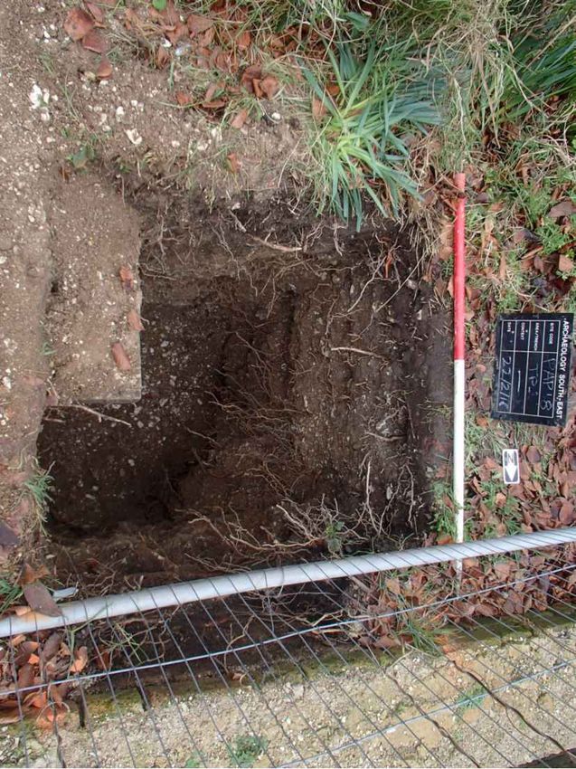
Archaeology South-East
                                                                 SS Peter & Paul Church,
                                                                        Gravesend,Kent
                                                                 ASE Report No: 2018078

Abstract

This report presents the results of an archaeological watching brief on a test pit at St
Peter & St Paul Church, Gravesend. The work was commissioned by Gravesham
Borough Council and was carried out by Archaeology South-East on the 22nd February
2018.

No archaeological features, deposits or finds were encountered during the watching
brief.

                                                             © Archaeology South-East UCL
                                           i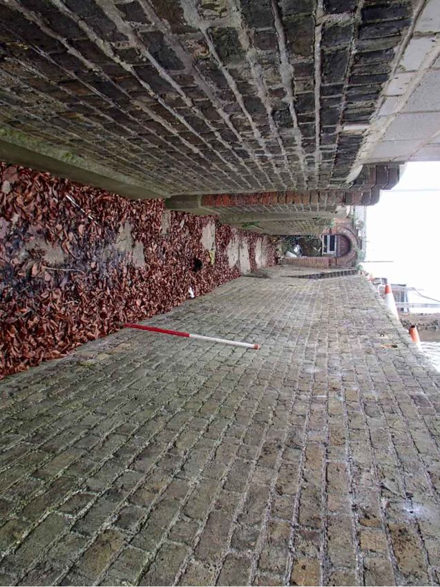
Archaeology South-East
                                                                SS Peter & Paul Church,
                                                                       Gravesend,Kent
                                                                ASE Report No: 2018078

                                   CONTENTS

1.0     Introduction

2.0     Archaeological Background

3.0     Archaeological Methodology

4.0     Results

5.0     Discussion and Conclusions

Bibliography
Acknowledgements

HER Summary
OASIS Form

TABLES:

Table 1: Quantification of site paper archive
Table 2: Quantification of artefact and environmental samples
Table 3: Test pit 1 list of recorded contexts

FIGURES

Figure 1: Site location
Figure 2: Site plan
Figure 3: Site photographs

                                                         © Archaeology South-East UCL
                                        ii
Archaeology South-East
                                                                SS Peter & Paul Church,
                                                                       Gravesend,Kent
                                                                ASE Report No: 2018078

1.0     INTRODUCTION

1.1     Site Background

1.1.1   Archaeology South-East (ASE), the contracting division of The Centre for
        Applied Archaeology at the Institute of Archaeology, University College London
        (UCL), were commissioned by Gravesham Borough Council (hereafter ‘the
        client’) to undertake an archaeological watching brief on St Peter & St Paul
        Church, Gravesend, Kent (hereafter referred to as 'the site'), centred on NGR
        65861 73838 (Figure 1).

1.1.2   The work was required by Rochester Diocese’s faculty ahead of the removal
        and rebuilding of a retaining wall to the north west of the church building.

1.2     Geology and Topography

1.2.1   The site is located within the town of Gravesend in Kent and is bounded by
        East Milton road to the south, and by Raphael road to the west running to the
        northeast. The land is currently occupied by a large churchyard and St Peter
        and St Paul Church. The site is positioned at the base of a slight hill, which
        slopes up from east to west along the route of East Milton road.

1.2.2   According to the British Geological Survey 1:50,000 scale geological mapping
        available online (BGS 2018), the natural bedrock geology of the Site comprises
        of Lewes Nodular Chalk Formation, Seaford Chalk Formation and Newhaven
        Chalk Formation (undifferentiated) - Chalk.

1.3     Scope of Report

1.3.1 This report details the findings of the archaeological watching brief carried out
      on 22nd February 2018. The archaeological work was undertaken by Jake
      Wilson. The project was managed by Paul Mason (fieldwork) and by Dan Swift
      (post-excavation).

                                                            © Archaeology South-East UCL
                                          1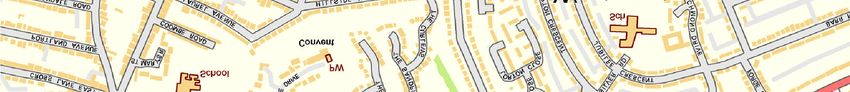
Archaeology South-East
                                                                SS Peter & Paul Church,
                                                                       Gravesend,Kent
                                                                ASE Report No: 2018078

2.0    ARCHAEOLOGICAL BACKGROUND

2.1    The archaeological potential is based on the proximity of the archaeological
       remains presently recorded in the Kent Historic Environment Record (HER)
       and these are summarised below.

2.2    Prehistoric 450 000BC-AD42

2.2.1 Evidence for human activity in the vicinity of the site stretches back to the
      Palaeolithic with find-spots of axes (TQ67SW435, TQ67SW436). Lithics of
      Mesolithic date (TQ67SW379) and a Neolithic flint axe (TQ67SW26) have also
      been found within the area. Human activity continues into the Bronze Age with
      a find of a looped and socketed axe (TQ67SE4). Archaeological evidence of
      settlement in the Iron Age includes both settlement activity in the form of pits
      and ditches (TQ67SW424, TQ67SW378) and artefactual evidence including a
      coin (TQ67 SE5).

2.3    Roman AD43-409

2.3.1 An occupation site of Roman date has been recorded in the area
      (TQ67SW110) along with pits, ditches and an inhumation burial
      (TQ67SW374). Samian ware has also been recovered in the vicinity (TQ67
      SE3).

2.4    Early Medieval AD410-1065

2.4.1 Limited early medieval (Saxon) activity has been identified through the
      excavation of pits (TQ67 SW375).

2.5    Medieval AD1066-1539

2.5.1 The town appears to expand in the later medieval period with the town itself
      being recorded in documentary sources (TQ67SW172). Also recorded are a
      manorial complex (TQ67SW233), cess pits (TQ67SW232) and further
      undefined pits (TQ67SW131).

2.6    Post-medieval AD1540-1900

2.6.1 Numerous buildings are recorded within the vicinity of the site during the post-
      medieval period, including breweries and house foundations. The railway also
      passed close by.

2.7    Modern AD1900-present

2.7.1 Features relating to World War II, including an emergency water tank, were
      located within 1000m of the site; in addition, air raid shelters, firewatchers’
      headquarters, a police telephone box and a civil defence control centre were
      all located in the vicinity.

                                                           © Archaeology South-East UCL
                                          2
Archaeology South-East
SS Peter & Paul Church,
Gravesend,Kent
ASE Report No: 2018078
2.8 Project Aims and Objectives
2.8.1 The general aims of the evaluation were:
To define, insofar as possible, the date, character, form and function of any
archaeological features observed on site.
To establish the presence or absence of archaeological remains within the
footprint of the proposed groundwork and to preserve by record any such
remains.
To determine the survival, extent and minimum depth below modern ground
level of any such remains.
To determine the nature and significance of any archaeological and/or
geoarchaeological deposits.
© Archaeology South-East UCL
3Archaeology South-East
SS Peter & Paul Church,
Gravesend,Kent
ASE Report No: 2018078
3.0 ARCHAEOLOGICAL METHODOLOGY
3.1 Fieldwork Methodology
3.1.1 The location of the test-pit is shown on Figure 2. The test pit was scanned prior
to excavation using a Cable Avoidance Tool (CAT) operated by accredited
ASE personnel.
3.1.2 The test pit was excavated by hand under the supervision of an experienced
Archaeologist with all spoil placed at least 0.5m away from the test pit edge.
3.1.3 All deposits were recorded using standard ASE context sheets with colours
recorded by visual inspection only. A digital photographic record was made of
the work. The spoil heap and the test pit base were scanned by eye for
unstratified artefacts.
3.1.4 All recording and planning was conducted in accordance with the Kent County
Council specification for archaeological watching briefs (KCC 2007).
3.2 Archive
3.2.1 The site archive is currently held at the offices of ASE and will be deposited at
a local museum in due course. The contents of the archive are tabulated below
(Table 1).
Context sheets 2
Section sheets 0
Plans sheets 0
Colour photographs 0
B&W photos 0
Digital photos 11
Context register 0
Drawing register 0
Watching brief forms 1
Trench Record forms 0
Table 1: Quantification of site paper archive
Bulk finds (quantity e.g. 1 bag, 1 box, 0
0.5 box 0.5 of a box )
Registered finds (number of) 0
Flots and environmental remains from 0
bulk samples
Palaeoenvironmental specialists 0
sample samples (e.g. columns,
prepared slides)
Waterlogged wood 0
Wet sieved environmental remains 0
from bulk samples
Table 2: Quantification of artefact and environmental samples
© Archaeology South-East UCL
4Archaeology South-East
SS Peter & Paul Church,
Gravesend,Kent
ASE Report No: 2018078
4.0 RESULTS
4.1 Trench 1 (Figure 3)
Length Width Depth m
Context Type Interpretation m m
[1/001] Layer Made Ground 1m 1m 0.27m
[1/002] Layer Made Ground 1m 1m 1.23m+
Table 3 Test pit 1 list of recorded contexts.
4.1.1 Test pit 1 was located to the northwest of the church building and measured
1m x 1m in length and 1.5m in depth.
4.1.2 Deposit [1/002] was a post-medieval made ground consisting of a light brown
chalk clay mixed infrequently with post-medieval building rubble and chalk
deposits.
4.1.3 Overlying [1/002] was deposit [1/001], another post-medieval made ground
consisting of a dark brown silt-clay mixed frequently with post-medieval
building rubble.
© Archaeology South-East UCL
5Archaeology South-East
SS Peter & Paul Church,
Gravesend,Kent
ASE Report No: 2018078
5.0 DISCUSSION AND CONCLUSIONS
5.1 Overview of stratigraphic sequence
5.1.1 The test pit excavated on site exhibited the same stratigraphy throughout. A
layer of post-medieval made ground [1/002], was overlain by a secondary layer
of post-medieval made ground [1/001]. The depth of the test pit did not exceed
1.50m and the excavation did not expose the natural geology.
5.2 Deposit survival and existing impacts
5.2.1 The area in which the watching brief took place had been affected by moderate
groundworks including multiple layers of post-medieval made ground; possibly
all up-cast from the construction of the large post-medieval wall running to the
north of the site and bordering the churchyard.
5.3 Consideration of aims and objectives
5.3.1 The conditions on site were conducive to confident and efficient identification
and recording of the test pit and as such it is considered that this watching brief
has successfully achieved its objective.
5.4 Conclusions
5.4.1 The watching brief has succeeded in establishing the presence and minimum
depth of the post-medieval made ground within this area of the churchyard,
adjacent to the retaining wall.
5.4.2 No archaeological features, deposits or finds were encountered within the test
pit.
© Archaeology South-East UCL
6Archaeology South-East
SS Peter & Paul Church,
Gravesend,Kent
ASE Report No: 2018078
BIBLIOGRAPHY
British Geological Survey (BGS), Geology of Britain Viewer Accessed on 15th
December 2018http://mapapps.bgs.ac.uk/geologyofbritain/home.html
Kent County Council, 2007 Standard Specification for an Archaeological Watching
Brief/evaluation/excavation
ACKNOWLEDGEMENTS:
ASE would like to thank Gravesham Borough Council for commissioning the work and
for their assistance throughout the project.
© Archaeology South-East UCL
7Archaeology South-East
SS Peter & Paul Church,
Gravesend,Kent
ASE Report No: 2018078
HER enquiry no.
Site code
PAP18
Project code
171209
Planning reference
-
Site address
SS Peter and Paul Church, Gravesend,
District/Borough
Kent
NGR (12 figures)
65861 73838
Geology Lewes Nodular Chalk Formation, Seaford Chalk Formation and
Newhaven Chalk Formation (undifferentiated)- Chalk.
Fieldwork type WB
Date of fieldwork
22/02/18
Sponsor/client
Gravesham Borough Council
Project manager
Paul Mason
Project supervisor
Jake Wilson
Period summary
Post-Med Other
Project summary An archaeological watching brief on a test pit was conducted at SS
Peter & Paul Church, Gravesend, Kent, NGR 65861 73838, on the
(100 word max) 22nd of February 2018. One test pit measuring 1m in length/width
was excavated by hand. No archaeological features, deposits or finds
were encountered during the watching brief.
Museum/Accession
No.
© Archaeology South-East UCL
8Archaeology South-East
SS Peter & Paul Church,
Gravesend,Kent
ASE Report No: 2018078
OASIS ID: archaeol6-312015
Project details
Project name An Archaeological Watching Brief at SS Peter and Paul
Church, Gravesend Kent
Short description of This report presents the results of an archaeological
the project watching brief carried out by Archaeology South-East at SS
Peter and Paul Church, Gravesend, on the 22nd of February
2018. No archaeological features, deposits or finds were
encountered during the watching brief.
Project dates Start: 22-02-2018 End: 22-02-2018
Previous/future No / No
work
Any associated PAP18 - Sitecode
project reference
codes
Type of project Field evaluation
Site status None
Current Land use Other 4 - Churchyard
Monument type - None
Significant Finds - None
Methods & ''Test Pits''
techniques
Development type Estate management (i.e. maintenance of existing structures
and landscape by capital works and on-going maintenance)
Prompt Faculty jurisdiction
Position in the Not known / Not recorded
planning process
Project location
Country England
Site location KENT GRAVESHAM GRAVESEND SS Peter and Paul
Church
Postcode DA12 2JL
Study area 1 Square metres
Site coordinates TQ 6576 7390 51.439293 0.385199 51 26 21 N 000 23 06 E
Point
Lat/Long Datum Position derived from charts
Height OD / Depth Min: 0m Max: 0m
Project creators
© Archaeology South-East UCL
9Archaeology South-East
SS Peter & Paul Church,
Gravesend,Kent
ASE Report No: 2018078
Name of Archaeology South East
Organisation
Project brief ASE
originator
Project design ASE
originator
Project Paul Mason
director/manager
Project supervisor Jake Wilson
Type of Client
sponsor/funding
body
Project archives
Physical Archive No
Exists?
Digital Archive Local Museum
recipient
Digital Media ''Images raster / digital photography'',''Text''
available
Paper Archive Local Museum
recipient
Paper Media ''Notebook - Excavation',' Research',' General
available Notes'',''Photograph'',''Report''
Entered by Jake Wilson (Tcrnjrw@ucl.ac.uk)
Entered on 19 March 2018
© Archaeology South-East UCL
10175000 N
174000
The Site
173000
0 0.5km
565000
566000
Contains Ordnance Survey data
Crown copyright and database right 2017
© Archaeology South-East St. Peter and St. Paul's Church, Gravesend, Kent
Fig. 1
Project Ref: 171209 March 2018
Site location
Report Ref: 2018078 Drawn by: NH1a,b & 1
c
12 N
AD
L RO
AE
age
PH
RA
tt
4.9m
Elm Co
2 1
Club
Section of wall to be demolished and rebuilt
Location of test pit
St Peter and
St Paul's Church
Lych Gate
E
S CLOS
LE
1 to 6
OF WA
Sundial House
PRINCE
Def
TCB 1 3
Site boundary EAST M
ILTON R
OAD
0 10m
Ordnance Survey (c) Crown Copyright 2016.
All rights reserved. Licence number 100022432
© Archaeology South-East St. peter and St. Paul's Church, Gravesend, Kent
Fig. 2
Project Ref: 171209 March 2018
Site plan
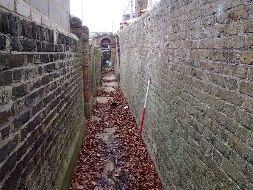
Report Ref: 2018078 Drawn by: NHTest pit 1, looking northeast
Test pit 1, looking west
Section of retaining wall (right) to be demolished and rebuilt
© Archaeology South-East St. peter and St. Paul's Church, Gravesend, Kent
Fig. 3
Project Ref: 171209 March 2018
Site photographs
Report Ref: 2018078 Drawn by: NHSussex Office Essex Office London Office Units 1 & 2 27 Eastways Centre for Applied Archaeology 2 Chapel Place Witham UCL Institute of Archaeology Portslade Essex 31-34 Gordon Square East Sussex BN41 1DR CM8 3YQ London WC1H 0PY tel: +44(0)1273 426830 tel: +44(0)1376 331470 tel: +44(0)20 7679 4778 email: fau@ucl.ac.uk email: fau@ucl.ac.uk email: fau@ucl.ac.uk web: www.archaeologyse.co.uk web: www.archaeologyse.co.uk web: www.ucl.ac.uk/caa
You can also read