WITH STEVE LANORE, CBM SEPTEMBER 1, 2020 - CRU ADJUSTERS
←
→
Page content transcription
If your browser does not render page correctly, please read the page content below
With Steve LaNore, CBM
September 1, 2020
Laura Lacerates Louisiana
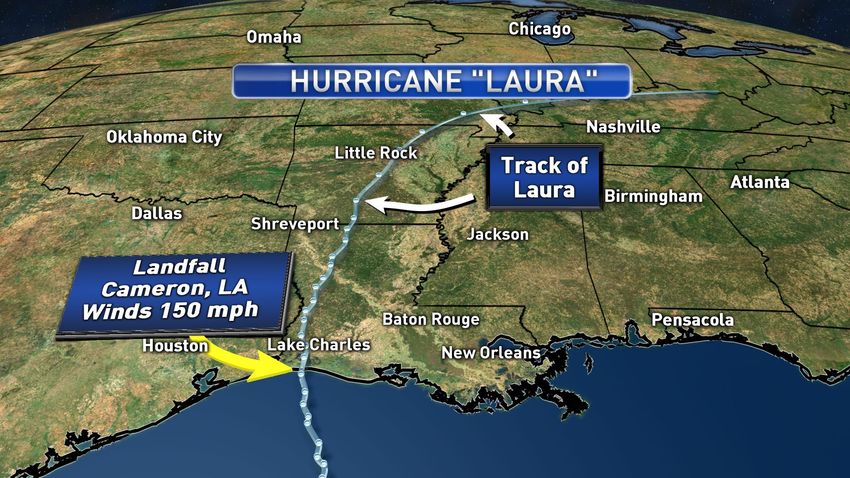
It’s one of the top 10 strongest hurricanes (at landfall) to ever strike the United States, and Lake Charles, city of
80,000 took damage more likened to a strong tornado than a hurricane. Of course we’re talking about Hurricane
Laura, which came ashore south of Lake Charles in the early hours of August 27.
Visible satellite image of Hurricane “Laura”: note the circular eye and symmetrical storm structure. This is a classic
example of an intense hurricane. Laura’s wind maxed out at 150 mph before landfall.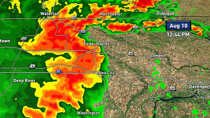
The Weather Channel dispatched meteorologists to the city in advance of the hurricane, one of them reported
from inside the Golden Nugget Casino there at the height of the storm. It was an eerie scene as the wind whistled
through the structure in a way both ghostly and violent as winds gusted to 133 mph.

Dawn broke and the hurricane was gone, people could assess the damage and pick up the pieces. But, there
wasn’t much left to look at in many cases. Thousands of homes and commercial buildings in Lake Charles and
nearby communities like Orange, Texas were severely battered. The damage in Lake Charles so bad that city
officials were asking residents to not return home unless absolutely necessary – the municipal water plant was all
but destroyed. Nearly a million people in Louisiana and far east Texas were using candles, flashlights and
generators for days – some still are. Tens of thousands of trees were blown over, with four people were killed in
separate incidents where trees toppled on their homes. As bad as it was, it was a stroke of luck that the damage
wasn’t worse:

>>> “Laura” produced only 14 tornadoes over the course of its track from Louisiana through Alabama – most
hurricanes of this intensity produce several dozen.

>>> It made landfall between the metro’s of New Orleans and Houston so it affected far fewer people.

>>> The rapid strengthening kept the storm surge from “catching up” to the wind, so the surge was lower than
expected.

Sadly, 16 people died and at least half of those succumbed to carbon dioxide fumes from improper operation or
placement of generators. Generators are getting a workout after Lake Charles city officials said power may be out
in some areas for weeks. It’s a helluva mess.
CoreLogic estimates damages from the storm at around $10B, similar to Florida’s Hurricane “Michael” in 2018,
which also struck a less populated area.

   Track of Hurricane “Laura”, which made landfall at 12:30 a.m. on August 27, 2020 near Cameron, Louisiana
Extreme Derecho, BILLIONS in damage August 10-11
We saw one earlier this year, it was a pretty big deal as it tracked from Kansas all the way past Nashville
Tennessee. That one racked up about $1B USD in damage, but it’s just a summer shower compared to this beast.
What is a Derecho? Well, the term is derived from the Spanish word for straight as in straight-line wind. It’s not a
tornado but can contain winds as high an EF3 twister (136-165 mph) in very rare cases. This one was huge,
covering hundreds of miles in length and up to 50 miles width at times. The August 10th Derecho was definitely
one of the most intense and longest-lasting on record.
National Weather Service: Shelf cloud with destructive wind beneath approaching Sugar Grove, IL.
Image from Maddie Murphy, NWS / Public Domain image
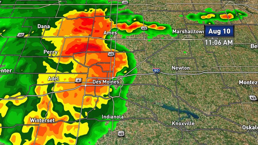
It took shape the morning of August 10 over Nebraska and plowed eastward across Iowa, Illinois, Missouri,
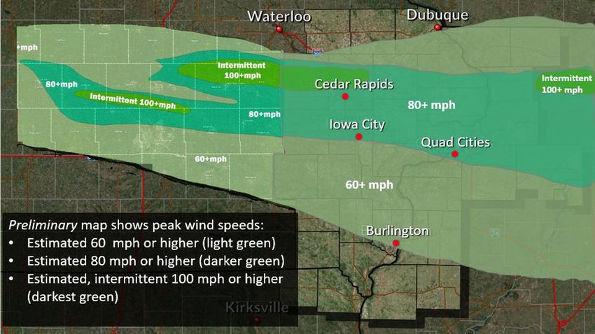
southern Wisconsin and Indiana. Iowa took the worst of it with winds over 100 mph recorded in numerous
locations, Cedar Rapids was the “ground zero” for this straight-line wind hurricane. Four million people were left
in the dark in the wake of this storm.
Iowa’s Governor Kim Reynolds asked the Federal Government for a “fast-track” disaster declaration to help
counties shredded by the ultra-derecho. The system wiped out a third of Iowa’s crops producing $3.75 Billion in
agricultural losses and about $250 million in non-farm losses. It also smashed through power infrastructure in the
state, leaving about $100 million in damage for private utilities to fix. This was a REALLY high-end event to have
such scope and level of damage.
And then there was Illinois, where winds to 85 mph clobbered Chicago, and a tornado started in the north side of
town only to move over the lake and become a waterspout! Crazy stuff. In an interview with the Washington
Post, a spokesman for Commonwealth Edison (the largest electric utility in Illinois) said, “It’s not just a repair
job...in some of the areas that are impacted, it’s actually a rebuild.”
Cedar Rapids Clobbered…but it had lots of company
In far too many ways, August 10 was Cedar Rapid’s version of Hurricane Laura. Winds of over 100 mph, Category
2 hurricane strength, clawed through much of the town. One hundred and forty structures were decimated and
thousands more damaged to varying degrees. Fifty people were injured. Nearly 8,000 homes and businesses in
the Cedar Rapids vicinity remained without electricity a full 11 days after the storm. That’s almost unheard of in
2020. Below is a progression of the storm system that traveled 770 miles in 14 hours: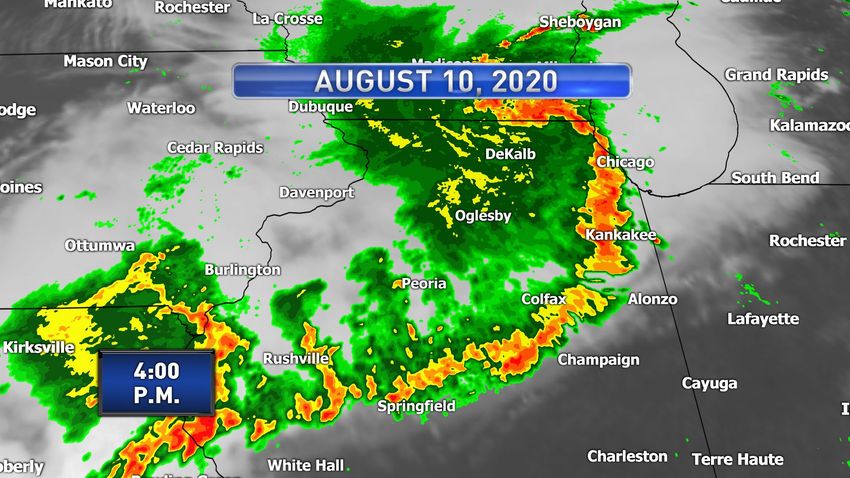
It started in the Omaha vicinity…

                            Des Moines, Iowa’s capital, was raked by 80-mph winds.

Des Moines is Iowa’s largest city at a half million (metro area) population, and many of them were probably on-
line or on the phone to the insurance carrier after the Derecho slammed the metro area with hurricane force
winds, residents reported the screaming winds lasted for 20 minutes! The fierce winds left 100,000 capital city
citizens in the dark, and up to four million across several states were without power during the day.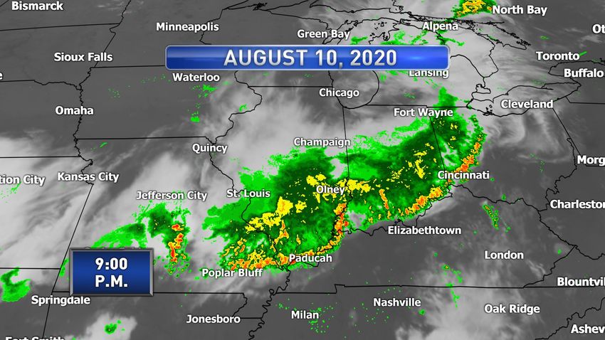
Cedar Rapids, a moderate-sized city of 130,000, is devastated by the derecho. Note the “bow” shaped radar
pattern right next to Cedar Rapids, this is often a warning sign of high winds within a line of storms. Wind damage
is consistent with winds of 100 mph to as much as 140 mph in some parts of town, which would be a state record
            wind speed. That’s the same wind speed as found in an EF-3 tornado…or a Cat 4 hurricane.

                                 Courtesy Quad Cities National Weather Service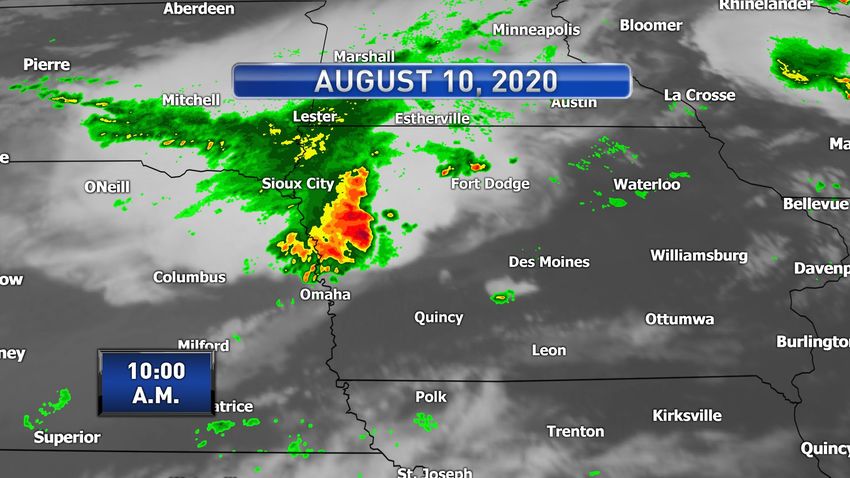
Chicago was walloped by winds up to 85 mph six hours after the Derecho swept past Omaha. An EF-1 tornado
 with winds of 110 mph formed from the storm complex, the strongest tornado in Chicago since 1983. A total of
                               seven tornadoes skipped across the windy city.

St. Louis endured lesser damage, but winds of 60 mph still extended from Missouri to Ohio as the storm wound
down overnight Aug 10-11. Quite the hellacious storm! The total losses, including agricultural, at the hands of this
Derecho may be close to those from “Laura”. It’s definitely in that range. Astounding for a straight-line
windstorm, but then this is one suitable for your weather photo album.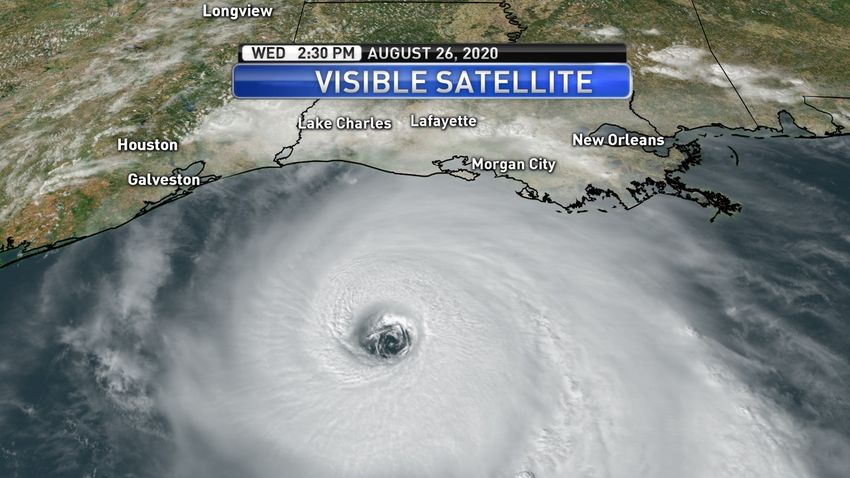
Before (above image) and after (below) images of how the wind changed Iowa’s crops for the worse / NASA

There were a few other rather widespread wind events in August too, New England and the mid-Atlantic took it
on the chin with a significant wind damage event the same day Laura came ashore (unrelated events) – August
27.

Over 400 reports of wind damage that day alone, including an EF-1 tornado that tracked across New Haven,
County Connecticut for 11 miles! Quite rare. The very next day, August 28 brought a second round of high winds
to PA and NJ – that’s a lot of downed trees and roof damage for one weekend. On top of that, the Boston metro
was mauled by high winds on August 23 as part of a storm system that slammed much of eastern Massachusetts.

All in all, there’s been plenty of work in these areas to say the least, and there’s no place where this is truer than
in the Derecho-ravaged areas of the Midwest. It’s been close to a month and they’re still putting the pieces back
together from that one. And then there’s Laura - which will take a while to sort through as well.
Wicked Wildfires return to California, some 3,000 structures incinerated

An historic “salvo” of lightning strikes combining with 100-degree plus temperatures brought anew the horrors of
2017 and 2018, when northern California saw its worst wildfire devastation ever. The lightning assault started on
August 14 and continued until the 16th. Most of the fires were started by these “dry” thunderstorms. This type of
storm happens every year over the western U.S. from Colorado to Arizona and California, but this barrage was
epic for the state. Consider that the entire state of California gets about 85,000 lightning strikes in a year – and a
small sector of the state around the Bay area got nearly 11,000 in just three days.

The two most damaging fires were the LNU Lightning Complex, around Vacaville, it consumed 1,200 structures.
The equally destructive CZU August Complex (Santa Cruz and San Mateo Counties) turned about 1,400 buildings
to cinders, according to the National Interagency Fire Center, (NIFC). Property losses collectively for the two fires
are in the low billions. Statewide, over 3,000 structures have been incinerated in California wildfires this year.
During the height of these two fires, 136,000 citizens were displaced by evacuations.
2018 still holds the top spot for worst fire season in California history with $10B in damage, 20,000 structures
destroyed, and 85 tragic deaths. Large fires in other western states especially Colorado have been primarily in
rural areas with minimal property loss.
August 19, 2020: Smoke shrouds northern California as hundreds of thousands of acres burn / NASA
Hurricane Season: What’s up Next?
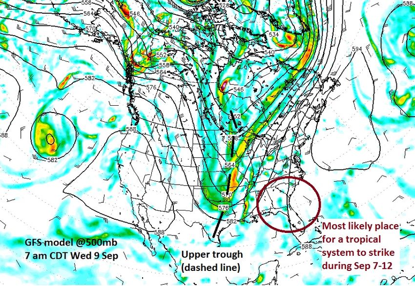
The long-range forecast shows a deep upper wave taking shape over the central U.S. during the second week of
September (see map below) and this would tend to favor a southeastern U.S. impact IF anything moves our way.
It should be noted that with the exception of Category 4 Hurricane Laura, tropical cyclones this year have
generally been quite weak, we’ve had twelve tropical storms and four hurricanes with Laura the only major
hurricane.
There’s no way to know what lurks in the weeks ahead except to say any U.S. impact would favor the
southeastern states in the second week of September.
The season peaks in mid-September but as we’ve seen in recent years with “Matthew” in October of 2016 and
“Michael” in October of 2018 we cannot write off the season too early. There’s plenty of trouble ahead.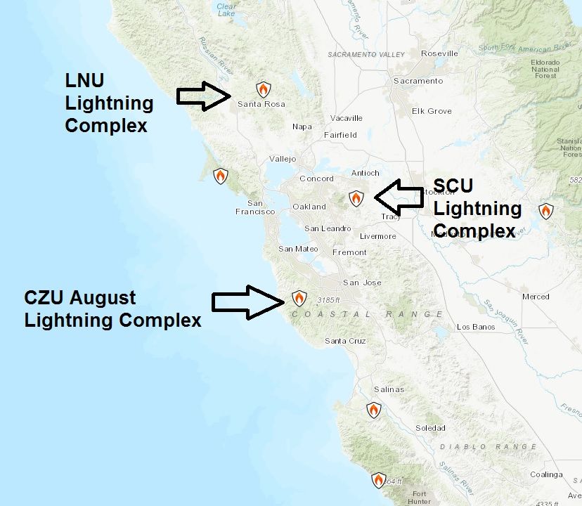
The wind flow parallels the black lines, so the steering wind is blowing FROM the north over Texas in this image
and FROM the south over Florida…making Florida the more likely place to get hit by a tropical system. The
Sunshine State has been incredibly lucky the past couple of years with its amazing dodge of “Dorian” in 2019 truly
fortunate.

Take Care,

Steve LaNore, CBM
You can also read