Tropical Cyclone Track Prediction - David A. Zelinsky and Richard J. Pasch National Hurricane Center 2021 RA-IV Workshop on Hurricane Forecasting ...
←
→
Page content transcription
If your browser does not render page correctly, please read the page content below
Tropical Cyclone Track
                    Prediction
                       David A. Zelinsky and Richard J. Pasch
                            National Hurricane Center
            2021 RA-IV Workshop on Hurricane Forecasting and Warning
                                   April 28, 2021

4/28/2021                       Tropical Cyclone Track Prediction      1
Outline
• Basic Dynamics
• Guidance Models
• Track Forecasting at NHC
  • Practical considerations
  • Verification

  4/28/2021              Tropical Cyclone Track Prediction   2
Tropical Cyclone Motion

• Tropical Cyclones generally move with
  the large-scale atmospheric flow
  • Similar to a leaf or a cork in a stream
• Track Forecasting is a relatively well-
  understood problem
• Important atmospheric features are
  often large and identifiable
• Numerical computer models forecast
  track fairly well (most of the time)

    4/28/2021                    Tropical Cyclone Track Prediction   3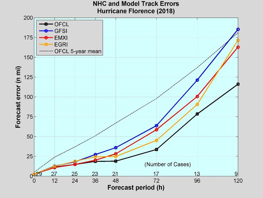
Tropical Cyclone Motion

• To a first approximation, TC motion is governed by conservation of relative
  vorticity (vortex moves with the large-scale steering flow).
• Second order includes the Beta term (conservation of absolute vorticity).
• Divergence term (e.g., wavenumber 1 asymmetry in convection, interactions
  with orography, friction)
• Vertical motions (e.g., twisting term) less important.
• 3-d dynamical model includes all of these terms.

4/28/2021                        Tropical Cyclone Track Prediction              4
Intensity impact on Track

            Note that changes in
             inner core structure
            appear to have little
              influence on track.

4/28/2021                           Tropical Cyclone Track Prediction   5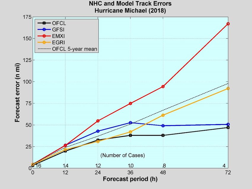
Large Scale Steering

                                                     H
             L                                 L

4/28/2021        Tropical Cyclone Track Prediction       6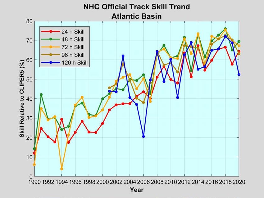
The Beta Effect
• The circulation of a TC,                           HIGHER VALUES OF EARTH’S VORTICITY

  combined with the North-                                                                   INDUCED
  South variation of the
                                                                            H
                                                                                             STEERING

  Coriolis parameter, induces                                                             2-4 kt to the NW

  asymmetries known as
  Beta Gyres.                          βv0

• Beta Gyres produce a net
  steering current across the
  TC, generally toward the                                     L
  NW at a few knots. This
  motion is known as the
                                                                                           N
  Beta Drift.
                                                     LOWER VALUES OF EARTH’S VORTICITY

   4/28/2021               Tropical Cyclone Track Prediction                                       7
Exercise 1
- You are given deep-layer mean wind plots
for 3 tropical cyclones (TCs) that were
located in the vicinity of 24-25 N 67-70 W.
                              o        o

- Also shown are the subsequent 72-h
tracks taken by the 3 TCs.

- Match up each deep-layer flow chart with
the correct track.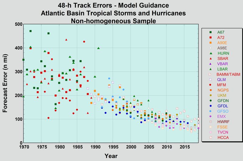
2. HUGO, 1989

                                                  1. FLOYD, 1993

            3. ANDREW, 1992

4/28/2021           Tropical Cyclone Track Prediction              12
Track Forecast Errors/Skill 4/28/2021 Tropical Cyclone Track Prediction 13
Average 72 h track forecast error in 1990

4/28/2021              Tropical Cyclone Track Prediction   14
Average 72 h track forecast error in 2020

4/28/2021              Tropical Cyclone Track Prediction   15
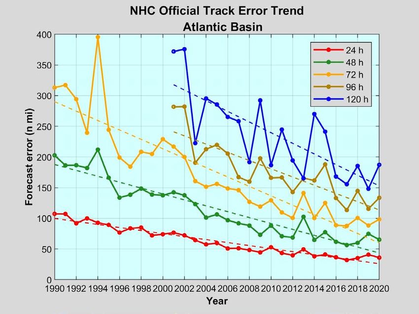
Model track forecast error trends

               Advancements in technology and science are
               primarily responsible for these large improvements
4/28/2021                       Tropical Cyclone Track Prediction   16
Hierarchy of Tropical Cyclone Models
• Statistical
• CLIPER/SHIFOR: Forecasts based on established relationships between storm-
specific information (i.e. location and time of year) and the behavior of previous
storms
• XTRP: Extrapolation from recent trends (or persistence)
• Simplified Dynamical
• TABS,TABM,TABD: Forecasts based on simplified dynamic representation of the
interaction between the vortex and prevailing flow (trajectories)
• Dynamical (Numerical Weather Prediction)
• Solve the equations of motion that govern the atmosphere (GFS, HWRF, etc)
• Statistical-Dynamical
• Use NWP forecasts and other input to statistically predict desired variables based
on past storm behavior (eg, regression, neural networks) (SHIPS, LGEM)
• Consensus
• Based on multi-model or single-model ensembles (TVCN, IVCN, HCCA, etc)
4/28/2021 Tropical Cyclone Track Prediction 17Climatology and Persistence Model (CLIPER)
• Statistical model, developed in 1972, extended from 3 to 5 days in
1998, re-derived in 2005.
• Developmental sample is 1931-2004 (ATL), 1949-2004 (EPAC).
• Required inputs:
• Current and 12-h old speed and direction of motion
• Current latitude and longitude
• Julian day, maximum wind
• No longer provides useful operational guidance, but is used as a
benchmark for other models and the official forecast. If a model has
lower mean errors than CLIPER it is said to be “skillful”.
• New version has been developed that can be extended to 7 days (or
beyond).
4/28/2021 Tropical Cyclone Track Prediction 18Simplified Dynamical Models
• Trajectory and Beta (TABS, TABM, TABD)
• Two-dimensional “trajectory” model. Uses
steering determined from a global model (GFS), TABD
averaged over a 400km radius circle around the
200
storm location at a given time. 300
• Adds a correction to simulate the Beta effect
TABM
Tropospheric Levels
400
(about 0.7 m/s) 500
• Includes a small component of persistence 600
TABS
• Three versions, representing different depths of 700
steering flow. The spread of these is a useful 800
indicator of environmental vertical shear: 900 Tropical
Depression
Tropical
Storm
Cat 1/2
Hurricane
Major
Hurricane
• TABS (shallow): 850-700 mb 1000- 990- 980- 970- 960- 950- 940-
• TABM (medium): 850-400 mb
1010 999 989 979 969 959
Typical Minimum Pressure
• TABD (deep): 850-200 mb
4/28/2021 Tropical Cyclone Track Prediction 19Three-Dimensional Dynamical Models
• Dynamical models
• May be global or limited area.
• May be grid point or spectral.
• May employ a “bogussing” scheme to represent the TC vortex.
• Global models
• Have inadequate resolution to define the TC inner core (eye and eyewall structure).
• Are often useful for forecasting TC size and outer wind structure.
• Have no lateral boundary conditions and therefore should have better performance at longer
ranges than limited area models.
• Limited Area (Regional) models
• Generally have higher horizontal resolution and are therefore more capable of representing
core structure and intensity change.
• Performance degrades at longer ranges.
4/28/2021 Tropical Cyclone Track Prediction 20SUMMARY OF NWP MODELS USED BY NHC FOR TC TRACK PREDICTION
Global/Regional Horizontal Vertical Levels Convective
ATCF ID Tracker Model Name Resolution and Coordinates
Data Assimilation
Scheme
Cycle/Run Frequency 2020 TVCN INCLUSION
60
Navy Global Spectral NAVDAS-AR Simplified Arakawa- 6 hr (144 hr)
NVGM/NVGI Hybrid Sigma- NO
Environmental Model ~31km 4D-VAR Schubert (SAS) 00/06/12/18 UTC
pressure
Simplified Arakawa-
Finite Volume GSI/4D-VAR
127 Schubert
Cubed Sphere EnKF hybrid, 6 hr (240 hr)
AVNO/AVNI (GFSO/GFSI) Global Forecast system Hybrid Sigma- [Arakawa and Schubert YES
(FV3) including TC central 00/06/12/18 UTC
pressure (1974) / Pan and Wu
13km pressure
(1994)]
12 hr (240 hr)
European Centre for 137
EMX/EMXI Spectral Tiedke mass flux 00/12 UTC
Medium-Range Weather Hybrid Sigma- 4D-VAR YES
EMX2 Forecasts
~9km
Pressure
[Tiedke (1989)] 06/18 UTC tracks
available in 2021
70 UKMET
EGRR/EGRI U.K. Met Office Grid Point 4D-VAR 12 hr (144 hr)
Hybrid Sigma- [Gregory and Rowntree YES
EGR2 Global Model ~10km
Pressure
Ensemble Hybrid
(1990)]
00/12 UTC
80 Kain -Fritsch 12 hr (240 hr)
Canadian Deterministic Grid Point 4D-VAR
CMC/CMCI Hybrid Sigma- [Kain and Fritsch (1990, 00/12 UTC NO
Prediction System ~25km ensemble Hybrid
Pressure 1993)]
SAS mom. mix. + GFS 6 hr (126 hr)
Hurricane Weather Grid Configuration 75 4D-VAR Hybrid
shallow convection (6km 00/06/12/18 UTC
HWRF/HWFI Research and Forecast 3 nests Hybrid Sigma- GDAS GFS YES
and 18km) Runs commence on
System 13.5-4.5-1.5 km Pressure IC/BC
2km nest – none NHC/JTWC request
6 hr (126 hr)
Hurricane Multi-scale Grid Configuration 00/06/12/18 UTC
HMON Ocean-coupled Non- 3 nests 51 None for this season SAS Runs commence on NO
hydrostatic model 18-6-2 km NHC/JTWC request
6 hr (126 hr)
NRL COAMPS-TC Grid Configuration Kain-Fritsch
3D-VAR (NAVDAS) 00/06/12/18 UTC
CTCX/CTCI (using GFS for IC and 3 nests 40 Kain and Fritsch (1990, YES
EnKF DART Runs commence on 1st
BC) 45-15-5 km 1993)
NHC/JTWC advisoryBut how do you make a track/intensity
forecast from raw model output?
4/28/2021 Tropical Cyclone Track Prediction 22Tracker Design • Need to determine a point location and maximum winds of a storm in model output to use while making a track or intensity forecast • An external tracker is applied to the model fields *after* the model run is complete • A weighted average of the centroid positions of several low-level variables is used: • 850 mb vorticity • 700 mb vorticity • Surface/10m vorticity • 850 mb geopotential height • 700 mb geopotential height • Mean Sea Level Pressure • 3 secondary parameters (850 mb/700 mb/10m wind speed minimum) 4/28/2021 Tropical Cyclone Track Prediction 23
Why the need for a multi-variate external tracker?

                                                              Gustav in GFS: The SLP
                                                              center was found 188
                                                              km from the vorticity
                                                                      center

4/28/2021                 Tropical Cyclone Track Prediction                            24
Early vs. Late Models
• Forecast cycle begins at synoptic time (e.g., 12Z), and forecast is released
at t+3 h (15Z).
• The 12Z runs of the dynamical models (HWRF, GFS, etc.), are not available
until 16Z-19Z, well after forecast is made and released.
• These models are known as “late models”
• Forecasts that are available in time for forecast deadlines are called “early”
models (TABs, CLIPER).
• For the 12Z forecast cycle, the latest available run of each model is taken
(from the 06Z or even 00Z cycle), and adjusted to apply at 12Z. These
modified forecasts are known as “interpolated” models (HWFI, GFSI, etc.).
25Early vs. Late Models
• Interpolated models are created by adjusting a smoothed
version of the previous model run such that its 6 h forecast
position exactly agrees with the current storm position. Then
the rest of the forecast is adjusted by the same vector.
30 h
24 h
18 h
12 h Actual 12Z position
6h
06Z GFS
26Early vs. Late Models
• Interpolated models are created by adjusting the previous model run
such that its 6 h forecast position exactly agrees with the current
storm position. Then the rest of the forecast is adjusted, with the
magnitude of the adjustment generally decreasing with time.
The “early” version of the model is
24 h
what the forecasters actually have
12Z GFSI
available to them when making a
forecast
12 h
OFCL is verified against the early
models
27But which model should you use?
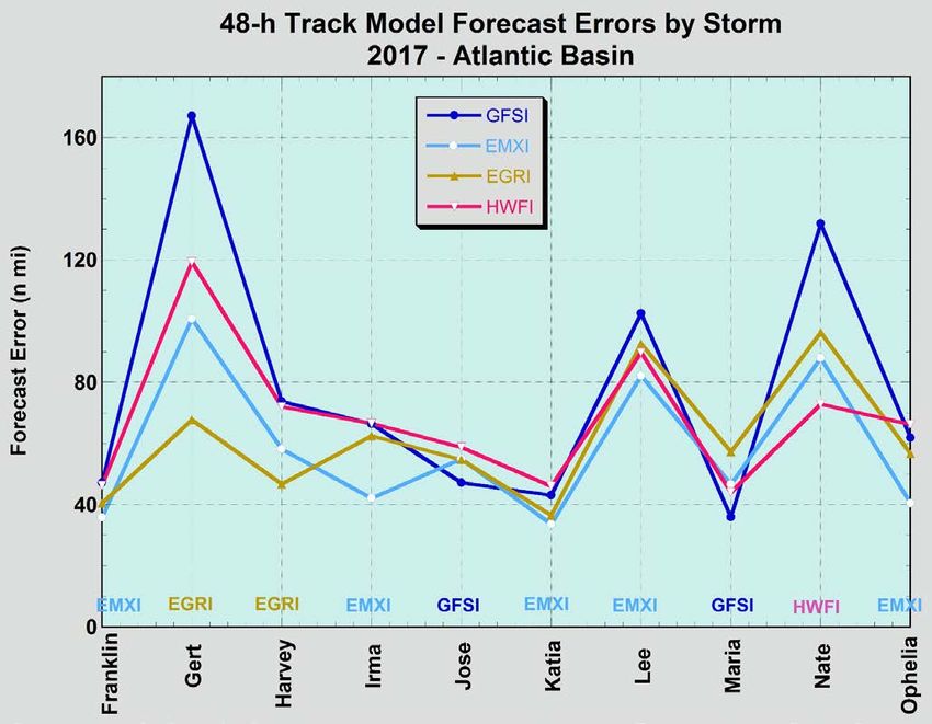
2848-h Model Track Errors by Storm
Considerable storm-to-storm variabilityFlorence and Michael
Ensembles and Consensus
• Often, the most successful
  models are consensus aids
  formed from an ensemble of
  good performing models with a
  high degree of independence.
• Recently, some single-model
  consensus models (especially
  the GFS ensemble) have
  performed as well as the
  deterministic version of the
  same model especially at
  longer ranges (day 5 and
  beyond).
Track Forecasting at the NHC:
                             Using Models
• Dynamical model consensus is an excellent first guess for the forecast (and often a good
  final guess!). Continuity dictates that it must be considered in view of the previous official
  forecast.
• Evaluate the large-scale environment using conventional data and satellite imagery (e.g.,
  water vapor)
   • Try to assess steering influences so that you understand and perhaps evaluate the model solutions

• Compare the models’ forecast of the environmental features, not just the TC tracks.
   • Evaluate the initialization of the TC in the model fields. Unrealistic TC can affect the likelihood of a
     successful forecast.
   • Consider the recent performance of the various models, both in terms of accuracy and consistency.
   • Spread of models can dictate forecaster confidence.

                                                                                             32
120-hr TVCA
Forecast
120-hr observed
center location
of Isaac72-hr observed
72-hr TVCA center location
forecast of Debby
Tropical Storm Debby 1800 UTC 23 June 2012
Of course, the consensus approach doesn’t always work! Sometimes the forecaster might want to exclude
certain models and form a “selective consensus”, if the discrepancies among the models can be resolved.
Resolving these discrepancies is often more difficult than some may have you believe!How do you resolve the difference between
guidance models?How do you resolve the difference between
guidance models?
Poor organization (esp. lack of
deep convection in the core)
would argue against Jeanne
being carried eastward by upper-
X level westerlies.
This reasoning allowed the
forecasters to largely disregard
the GFS and form a “selective
consensus” of the remaining
models.Additional Track Forecasting Considerations
• Previous official forecast exerts a strong constraint on the current
forecast
• Can damage credibility by making big changes from one forecast to the next,
and then having to go back to the original
Windshield
Tromboning
Wipering
• Consequently, changes to the previous forecast are normally made in
small increments
• Continuity is also important within a given forecast
• Gradual/steady changes in direction or speed from 12 to 24 to 36 h, etcDennis Guidance 6 July 1200 UTC
• Official forecast near model
consensus in extreme western
FL panhandle.Dennis Guidance 6 July 1800 UTC
• Guidance shifts sharply
westward toward New Orleans.
Official forecast nudged
westward into AL.Dennis Guidance 7 July 0000 UTC
• Little overall change to
guidance, but NGPI shifts
slightly eastward. Little
change in official forecast.Dennis Guidance 7 July 0600 UTC
• Rest of the guidance shifts
sharply eastward, leaving
official forecast near the
center of the guidance
envelope (and very close to
the actual track of Dennis.Track Forecasting at the NHC:
Importance of Initial Motion
• Accurate estimate of initial motion
is extremely important.
• Has dramatic impact on accuracy of
the CLIPER model at shorter ranges.
• Initial motion vector is also used in
some vortex bogussing schemes.
• 12-h NHC forecast is heavily weighted
by the initial motion estimate. 11%
• Not always easy to determine, 16%
particularly for systems with ill- 25%
43% improvement w/BT motion
defined centers.Trochoidal Motion
• Substantial oscillation (wobble) of the center of a TC about its mean motion vector
• Primarily a side effect of convective asymmetries in the inner core
• Amplitude of motions varies but higher-frequency “wobbles” lost in ‘best track’
smoothing process
• Virtually impossible to forecast!
43Track Forecasting at the NHC:
Determination of Initial Motion
• Initial motion typically computed using the
average motion over the previous 6, 12, or
18 h.
• Shorter when known changes in track are
occurring, longer when center location is
uncertain.
• Initial motion estimate should not reflect short-
term track wobbles (e.g., trochoidal
oscillations) that will not persist.
• NHC philosophy is that it is better to lag
events a little bit than to be going back and
forth with analyses or forecasts. We will
usually wait several hours before “calling” a
change in track.
44Track Forecasting Review What is the most important factor for tropical cyclone track? a) Large-scale steering flow b) Internal dynamics of the eyewall c) Beta effect d) Storm intensity
Track Forecasting Review

Which of the following is typically the best
type of model to use for track forecasting?

a) Statistical-dynamical model (SHIPS/LGEM)
b) High-resolution global model (ECMWF/GFS)
c) Multi-model consensus (TVCN/HCCA)
d) Regional hurricane model (HWRF/HMON)
Track Forecasting Review

If one the track of one model shifts significantly from its
previous track, what is the best thing to do?

a) Change the locations of the Hurricane Warnings to agree
   with this model.
b) Make a significant change to the official forecast from the
   previous advisory.
c) Adjust the official forecast slightly, but generally maintain
   continuity with the previous one.
d) Make no change to the official forecast.
You can also read