DPRI-VMGD joint survey for Cyclone Pam damages
←
→
Page content transcription
If your browser does not render page correctly, please read the page content below
DPRI-VMGD joint survey
         for Cyclone Pam damages

                   May 19, 2015

Disaster Prevention Research Institute, Kyoto University
                  Kazuyoshi Nishijima
                     Nobuhito Mori
                   Tomohiro Yasuda
                   Tomoya Shimura

   Vanuatu Meteorology and Geo-Hazard Department
                Jerry Timothy Gogon
                    David Gibson
                    Fred Jockley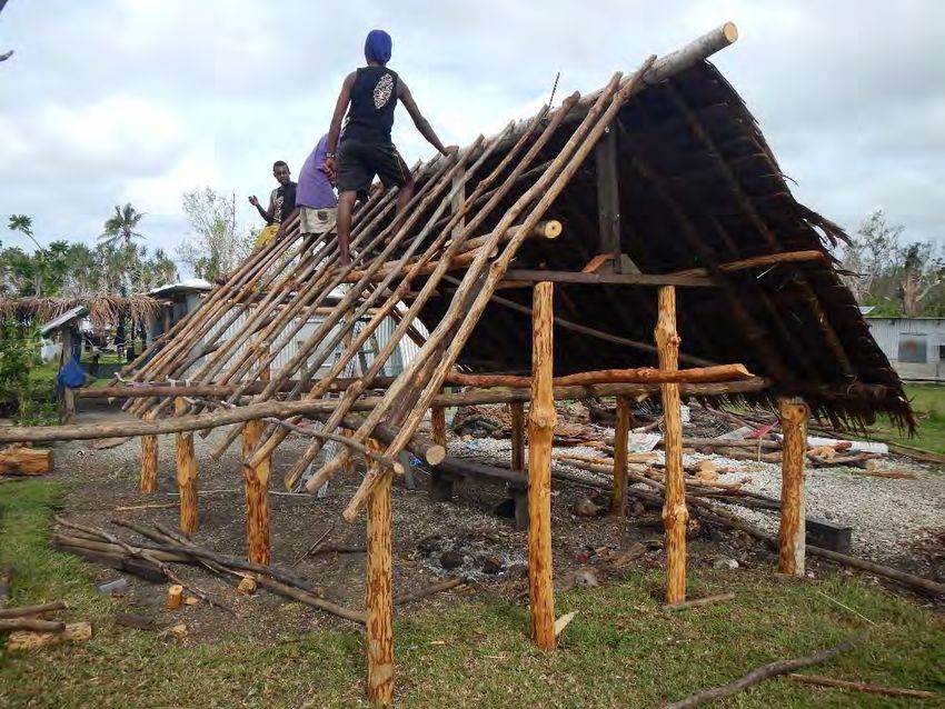
1. Survey Overview
1.1. Purpose
This survey was conducted for the purpose to archive Cyclone Pam-induced damages to
buildings as well as inundations along the coastlines, which is to be facilitated to
understand wind-resistant performance of the buildings as well as vulnerability of its
coastal areas, whereby identifying effective ways to improve the resilience of the built
environment to future cyclones.
1.2. Items to survey
Wind induced damages to buildings
Qualitative assessment of distributions on wind speed
Parameters related to wind-resistant performance
Wave induced damages to buildings and natural environment
Inundation heights
Inundation areas
Erosion of coasts
1.3. Survey areas
Efate island
Tanna island
1.4. Survey members
The survey was conducted jointly by Disaster Prevention Research Institute (DPRI),
Kyoto University, and Vanuatu Meteorology and Geo-Hazards Department (VMGD).
The members are listed up in Table 1.
Table 1. Survey members.
Name Affiliation and expertise
Kazuyoshi Nishijima Disaster Prevention Research Institute,
Kyoto University, wind engineering
Nobuhito Mori Disaster Prevention Research Institute,
Kyoto University, coastal engineering
Tomohiro Yasuda Disaster Prevention Research Institute,
Kyoto University, coastal engineering
Tomoya Shimura Researcher, Disaster Prevention Research Institute,
Kyoto University, coastal climate modeling
Jerry Timothy Gogon Vanuatu Meteorology and Geo-Hazards Department, forecasts
1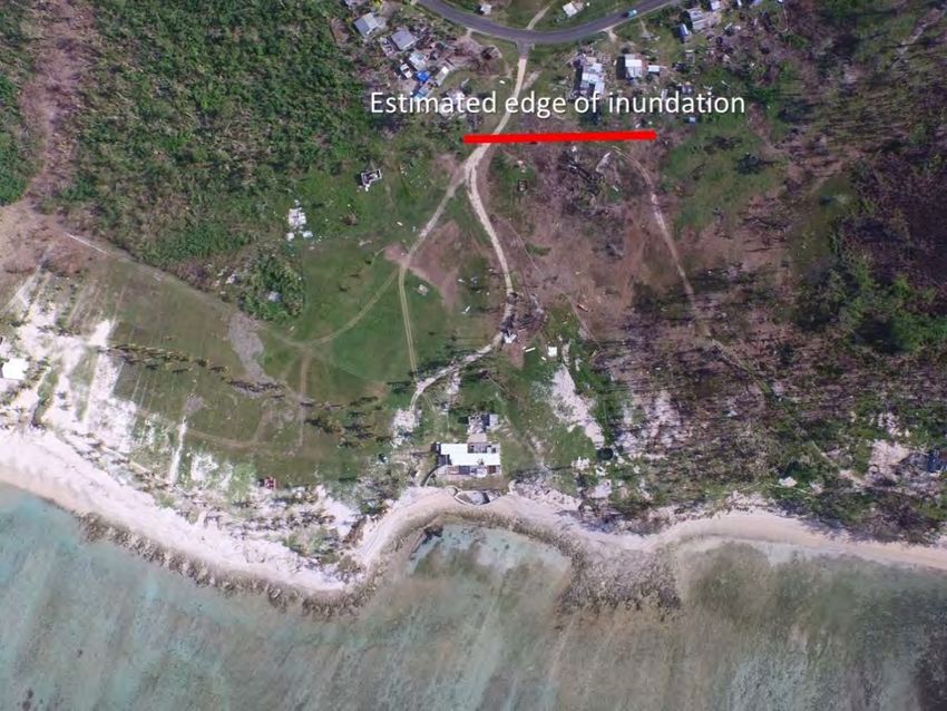
1.5. Survey itinerary
The survey was conducted between April 21 and 30, 2015. The itinerary is shown in
Table 2 and the areas of the survey are shown in Figure 1.

                                Table 2. Itinerary.

Date                 Activities
April 21             Depart Osaka, Japan, for Port Vila, Vanuatu, via Tokyo and
                     Auckland.
April 22             Arrive at Port Vila. Briefing meeting with Mr. Gogon and
                     JICA local staffs.
April 23             Visit to Vanuatu Meteorology and Geo-Hazards Department.
                     Visit to Ministry of Climate Change and Natural Disaster.
                     Survey in Port Vila and east coast of Efate Island (Eton, Epao,
                     Onesua).
April 24             Visit to Ministry of Land.
                     Visit to Public Works Department of Vanuatu.
                     [Team Wind]
                     Survey of buildings in Port Vila and south to east coast of
                     Efate Island (Eton, Epao, Ekipe).
                     [Team Coast]
                     Survey in west to north coast of Efate Island (Pango road,
                     Black sand, Takara (Baofatu), Ekipe).
April 25             Move to the Tanna Island.
                     Survey in west coast of Tanna Island (Green point, Isangel,
                     Kwataparen, Lenava).
April 26             Survey in east coast of Tanna island (Loutapunga, Waisisi,
                     Natanu, Port Resolution).
April 27             [Team Wind]
                     Survey in west coast and middle of Tanna Island (Lenakel,
                     Yakel, Green Hill).
                     [Team Coast]
                     Survey in east coast of Tanna Island (Louniel, Epikel,
                     Waisisi).
April 28             Survey in Green hill.
                     Move to Efate Island.
April 29             Move to Auckland.
April 30             Return to Osaka via Tokyo.

                                                                                       2
Figure 1. Areas of survey.

        Figure 2. Locations of survey (left: Efate Island, right: Tanna Island).

2. Weather conditions

    2.1. Weather conditions
According to report by VMGD (2015), the tropical low system was christened “Pam” at
600 km northeast at 6:00 pm on the 9th of March 2015. Pam intensified into a CAT 4 at
11am, on 12 March 2015, and it became a CAT 5 system at 11am, on 13 March. Pam
approached to 45 km east of Port Vila at the midnight on Friday, 13 March 2015. Pam
moved to southwards, and then it passed 20 km west of Tanna at 8am on 14 March 2015
                                                                                   3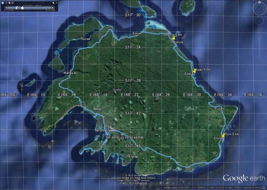
(see Figure 3). At 9am, on 11 March 2015, the first warning on Severe Tropical Cyclone
Pam was issued for the Northern provinces as the system was 425 km northeast of
Gaua. The Tropical Cyclone Warning Centre started to issue hourly warnings, from an
original three hours of warnings at midday, on Friday, 13 March 2015.

                        Figure 3. Track of TC Pam (VMGD, 2015).

Observed minimum central pressure was 986 hPa by satellite and 919 hPa by the
ground station at Tanna airport. There is few available weather stations observed wind
speed, atmospheric pressure and precipitation in Vanuatu. Therefore, it is important to
use analysis data. Figure 4 shows maximum wind speed at 10 m height, U10, by CFSR
analysis. It is expected that CFSR wind underestimates because it uses 20 km
resolution horizontally and it is too coarse to describe detail of topographic effects in the
islands. Beside the accuracy of analysis data, the maximum U10 exceeds 40 m/s around
Efate island. The measured maximum wind speed at the Tanna airport was 120 or 200
kt/h (62 or 103 m/s) at 10pm on 13 March and the instrument was broken after that.

                                                                                           4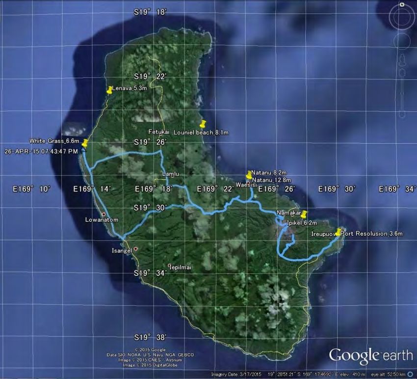
Figure 4. Maximum wind speed at height of 10 m by CFSR analysis.

    2.2. Ocean conditions
There are two tidal gauges in Vanuatu. The measured storm surge height at Port Vila
was 0.6 m and was mainly due to pressure surge because of less wind surge effects by
bathymetry around Port Vila. The estimation of wave field was conducted spectral wave
model; SWAN model version 40.91 was used to simulate wave spectral evolution. A
series of numerical experiments was performed to understand the characteristics of
extreme wave condition for this event before conducting the post-event field survey. The
source terms were given by the standard setup for Sin as Janssen’s linear growth, DIA
for nonlinear wave interactions and Sds as Komen’s dissipation, respectively.

Forcing of SWAN was the wind speed at 10 m height, U10, atmospheric reanalysis data
by CFSR by NOAA. The bathymetry was given by GEBCO 2014 Grid (a global 30
arc-second grid) with spatial linear interpolation. Three domains nesting scheme was
applied from 0.50 degree (about 56 km) to 0.009 degree (about 1 km), horizontally.
Storm surges were not considered in this analysis. The pressure surge was mainly
occurred due to steep volcanic bathymetry in Vanuatu and it can be estimated by the
atmospheric pressure.

Figure 5 shows the maximum significant wave height of domain 1 and 3. The estimated
wave heights around Efate and Tanna were 10–15 m and 10–18 m, respectively.
Although the estimated wave height is sensitive to track of Pam, the gradient of wave
height along the coast is significant especially at Tanna island. It is expected that the
severe wave effects can be expected at East coast of Tanna. The shading effect by
Erromango was strong the similar effects can be found behind of small islands around

                                                                                       5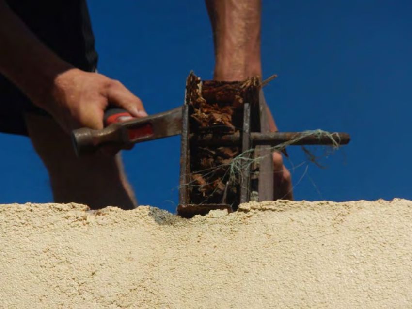
Tanna island. Based on SPC report, the simple empirical model suggest that wave
higher than 10 m occurred between Efate and Tanna and waves as height as 16 m may
have reached Erromango. The estimated extreme wave height of 100 years return
period was 7.5 m in this area before Pam. The simulated wave heights by Pam reached
twice as that estimation.

   Figure 5. Maximum significant wave height (unit: m). Top: Largest domain (D1),
           Bottom left: Efate island (D3), Bottom right: Tanna island (D3).

                                                                                    6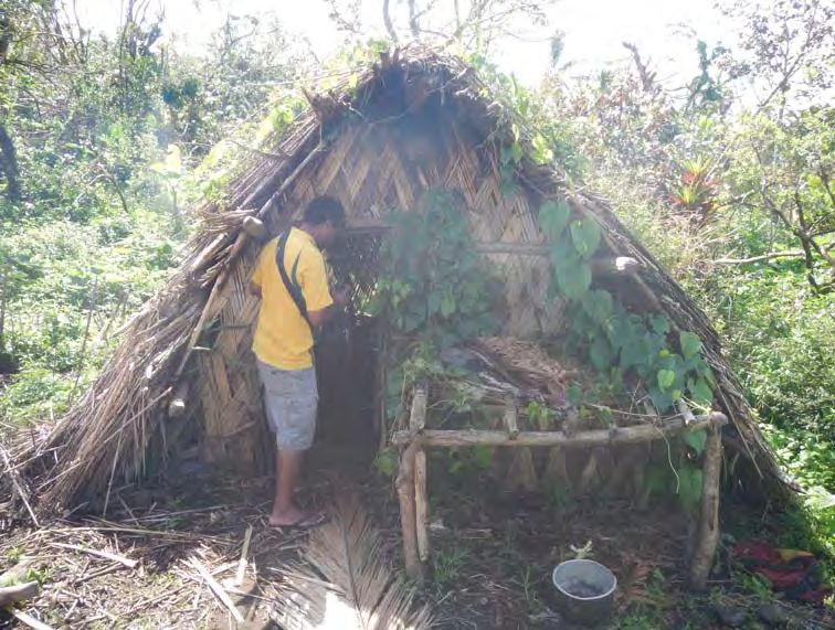
3. Reported damages summary
According to the document by UNOCHA, 166,600 people were affected and 11 people are
dead by the Cyclone Pam, and 75,000 people in need of shelter. It also reports that Shefa
and Tafea were the most affected provinces – Efate Island is located in Shefa and Tanna
Island is located in Tafea. In Tanna Island 50 percent of shelters has been destroyed.

The following information sources provide overview on the impacts of Cyclone Pam:

The Pacific by OCHA:
http://www.unocha.org/rop/

Cyclone PAM portal by SPC:
http://www.spc.int/cyclone-pam-response/

Damage Assessment by UNITAR:
http://www.unitar.org/unosat/

4. Reporting of the survey

    4.1. Wind-induced damages to buildings

4.1.1. Overview of wind damages to buildings
Damages to buildings in Efate and Tanna Islands are reported here for traditional
buildings and modern buildings. Traditional buildings refer to buildings made of
materials locally available such as woods, canes and leaves. Sometimes, nails and
screws are used. On the other hand, modern buildings refer to non-traditional
buildings, ranging from engineered structures such as reinforced concrete structures,
over concrete block structures, and non-engineered structures made of timbers,
galvanized iron sheets, etc.. Typical occupancy types of modern buildings are
commercial, governmental, school and church. Those of traditional buildings are
residential and cyclone shelters.

Most of the damages to RC structures seem limited to non-structural components such
as envelops and interiors. The building in Figure 6 is a commercial building located in
Port Villa, Efate Island. As seen, the damages are limited to its envelop, part of which is
believed damaged due to lack of shutters. Significant damages are also observed to
interior such as ceilings and partitions. It should be noted that many commercial
buildings in Port Vila are equipped with shutters, many of which seem undamaged.

                                                                                         7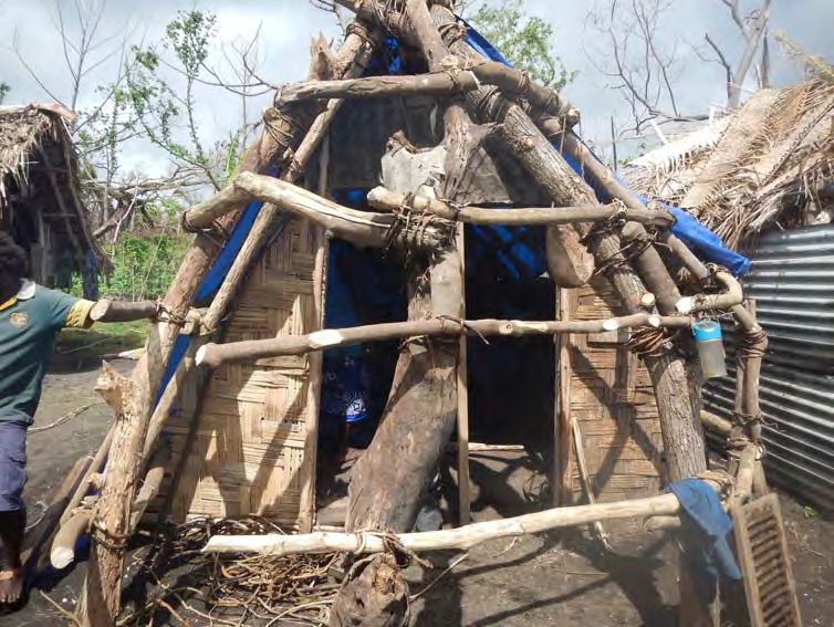
Generally speaking, quality of construction work is good; however, several buildings
with low quality construction were observed.

Collapses of concrete block structures were also observed. The totally collapsed building
seen in Figure 7 is located in Tanna Island. The mortar joints seem relatively weak, and
amount of rebar few and it lacks stiffness. It had been used as church and in the event
of the Cyclone Pam several people in the village first evacuated to the church.

Significant deterioration of components were identified in many modern buildings that
were damaged, see Figure 8. Steel connections are often rusted and un-treated timber
products were deteriorated in those buildings.

         Figure 6. Damages to envelop of commercial building in Efate Island.

                                                                                       8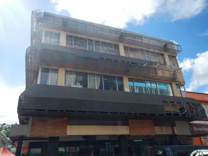
Figure 7. Totally collapsed church in Green Hill in Tanna Island.

 Figure 8. Deteriorated component of damaged school building.

                                                                    9
Most of traditional houses had been destroyed or damaged, according to the testimonies
of local people; however, many of them were already reconstructed when the survey was
conducted. Typical houses are made of woods for columns, beams and roof structures;
roofs are covered with dried leaves, grasses, wild canes and sometimes with support of
bamboos. Simple industrial construction materials such as nails and screws and
construction instruments such as chain saw are available in some cases. Figure 9 and
Figure 10 show traditional houses under reconstruction in two villages in Efate Island.
The house in Figure 10 has the dimension of 3140 mm in width, 2720 mm in height and
5270 mm in depth. It has narrow eaves. The columns are made of Mango tree. The
diameter of the columns is around 120 mm and the columns are casted into the soil by
around 500 mm. The rafters are made of Oak tree. The diameter of the rafters is around
60 mm. The ridgepole is made of a kind of nut tree. These trees were cut in the forest
nearby, brought to the site and cut with a chain saw. For the connections nails are used.
Figure 9. Traditional house under reconstruction at Eton, Efate Island.
10Figure 10. Traditional house under reconstruction at Epao, Efate Island.
4.1.2. Traditional cyclone shelters
There are several testimonies that people in villages in Tanna Island evacuated to
traditional cyclone shelters and those shelters did not fail during the cyclone. Figure 11
shows an example of the traditional cyclone shelter in Tanna Island and Figure 12
shows a traditional cyclone shelter that are being built after Cyclone Pam. Although the
dimensions and details are diverse, there is a common characteristics in the traditional
cyclone shelter. That is, the roof is extended to the ground. The shape seems empirically
optimized to best resist against strong wind.
It is remarkable that people in those villages take the warning messages serious and
evacuated to the traditional cyclone shelters, which are specially constructed for the
purpose to protect human lives in the events of cyclones – and it worked.
11Figure 11. Traditional cyclone shelter at Yakel in Tanna Island.
Figure 12. Newly constructed traditional cyclone shelter at Loutapunga in Tanna
Island.
124.2. Coastal damages
4.2.1. Overview of run-up and inundation height
Wave run-up and inundation heights were measured according to interview to local
residents by an auto-level and a laser range finder. The survey was follows protocol of
the post-tsunami survey field guide by IOC. Figure 13 displays the survey results in
Efate Island and Tanna Island. In Efate Island, coastal inundation was mainly observed
along the east coasts, e.g. Eton, Epao, and Onesua, and the maximum run-up heights
were about 5 m from the mean sea level (MSL) excluding tidal effects. In Tanna Island,
inundation heights were larger than that of Efate due to larger offshore wave height
shown in Figure 4. Along northwest coast of Tanna where the distance is close to the
cyclone eye, 5–6 m run-up above MSL was observed at Lanava and White Grass. On the
other hand, in the northeast coast of the island, large inundation which is 8 m was
observed where the fetch was the longest without shading effects of islands. Severe
beach cliff erosion was observed at Louniel beach, which height was about 6 m as shown
in Figure 14. Several ships made of FRP were flown and run-up at Natanu, Waisisi.
Inundation heights gradually decrease to south in the east coast due to shading of
peninsula. At Ipikel facing the Sulfur bay, inundation height was about 6 m, and at the
Port Resolution run-up height becomes less than 4 m. SPC report summarized that the
satellite image of the North East of Erromango shows major coastal erosion and
inundation. We observed similar phenomena by extreme waves in Tanna Island
visually.
(a) Efate Island.
13(b) Tanna Island.
Figure 13. Measured run-up and inundation height from MWL (unit: m).
Figure 14. Sevier coastal cliff erosion at Louniel beach in Tanna Island.
144.2.2. Detail of specific damaged area
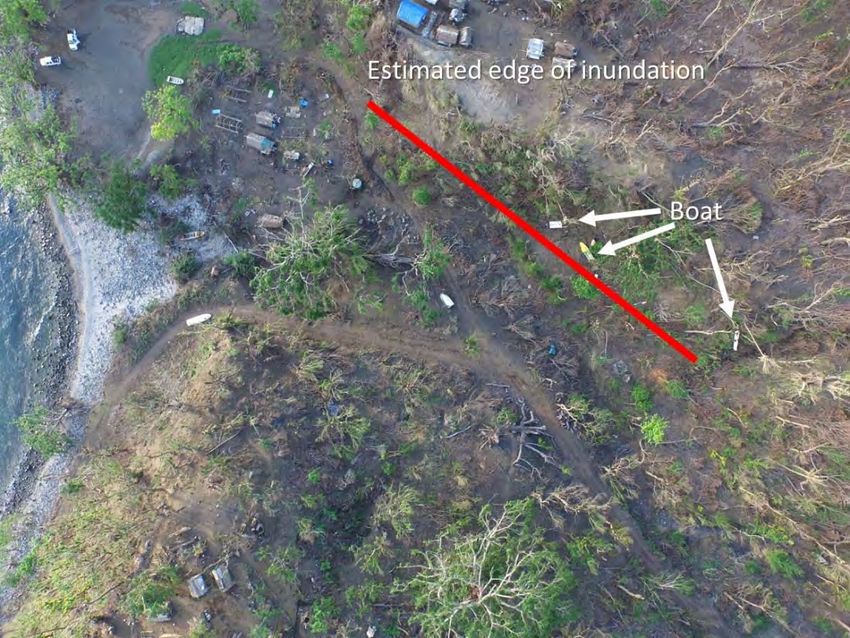
The long distance inundations were observed several locations. One example is Baofatu
beach (Takara hot spring) at the northeast coast of Efate island. Figure 15 (a) shows
aerial snapshot of observed coastal inundation by a drone. There are many boulders of
coral rocks from the reef and concrete blocks from coastal walls until 100 m along the
coast. The maximum distance of inundation is 300 m and it was remained more than 2
days according to witness evidence by local residence. The highest run-up of coastal
flooding was observed at Waisisi village in southeast coast of Tanna Island (Figure 15
(c)). The maximum run-up height was about 12 m and propagated up to 300 m from the
coast line. The severe coastal inundations are measured east coast of Tanna island that
feature is matched with numerical hindcast shown in Figure 5.
(a) Baofatu (Takara hot spring) in Efate Island.
15(b) Waisisi village in Tanna Island.
Figure 15. Snapshot of observed coastal wave inundation by drone.
Acknowledgements
This survey was conducted partly with DPRI rapid disaster survey fund and partly as
JSPS KAKENHI (Grand-in-Aid for Scientific Research) #15H05220 (PI: NM). The
survey team acknowledges Jotham Napat, Director general of the Ministry of Climate
Change, for giving us the permission to carry out research on Efate and Tanna Islands,
and David Gibson, Director of Meteorology and Geo-Hazards Department, for allowing
staff and department resources to facilitate this survey in Port Vila and Tanna Island.
The survey team also acknowledges great supports on logistics by Mr. Eisuke
Shimakawa, Mr. Akihiko Nakai and Mr. Koichi Sugawara in NHK (Japan Broadcasting
Corporation) as well as Mr. Hironobu Osuka in South Pacific Tours in Vanuatu. We also
thank to Ms. Asano and Mr. Matsuura, JICA local staffs, for briefing on the situations in
Vanuatu. Finally, but not least, we appreciate Mr. Antfalo’s support and effort for
preparing for this survey.
Reference
UNOCHA, Flash Appeal Emergency Response Plan for Vanuatu Tropical Cyclone Pam
March - June 2015.
16Vanuatu Meteorology AND Geo-Hazards Department (2015) Severe Tropical Cyclone
Pam, http://pcrafi.spc.int/static/pam/TropicalCyclonePamSwellSummary.pdf , 13p.
Secretariat of the Pacific Community (2015) Tropical Cyclone Pam waves summary, 9p.
International Tsunami Survey Team (ITST) Post-Tsunami Survey Field Guide. 2nd
Edition, IOC Manuals and Guides No. 37, 2014.
SWAN - Scientific and Technical documentation. Delft University of Technology,
Environmental Fluid Mechanics Section, available from http://www.swan.tudelft.nl
(Version 41.01, April 2014).
17You can also read