YUKON SNOW SURVEY BULLETIN & WATER SUPPLY FORECAST - April 1, 2019 - Prepared and issued by: Water Resources Branch Department of Environment ...
←
→
Page content transcription
If your browser does not render page correctly, please read the page content below
YUKON SNOW SURVEY
BULLETIN & WATER
SUPPLY FORECAST
April 1, 2019

                       Prepared and issued by:
                      Water Resources Branch
                    Department of Environment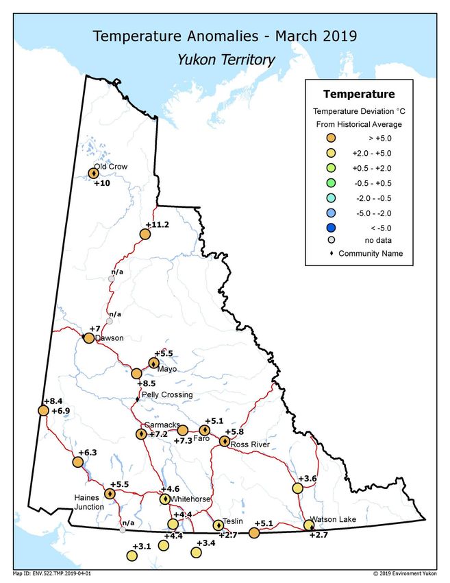
DEDICATION
The 2019 Yukon Snow Survey Bulletin and Water Supply Forecasts are dedicated to the memory of Ric Janowicz (1952
– 2018). As Senior Hydrologist for Environment Yukon for more than 35 years, Ric was keenly interested in expanding
the knowledge of northern hydrology. Ric promoted and contributed to the development of hydrologic models tailored to
northern climates in an ongoing effort to better understand river ice break-up processes and risks to flood-prone
communities.

Specific to the study of snow, Ric oversaw the significant expansion of the Yukon Snow Survey Network, establishing
more than 20 new long-term monitoring sites throughout the territory. Additionally, Ric rallied for the construction of
several remote meteorological stations equipped with snow pillows allowing for real-time monitoring of snowpack
accumulation and degradation across the season. These advancements allowed Ric to increase the effectiveness of the
flood forecasts that he produced through his work with Water Resources Branch.

Ric will be remembered for his unwavering devotion to his work; he will also be fondly remembered for his unique
personality, humour, stories, and above all from his colleagues, as a world-renowned hydrologist.

                                                                                                 YG Photo credit

  Yukon Snow Survey Bulletin and Water Supply Forecast April 1, 2019                                                 2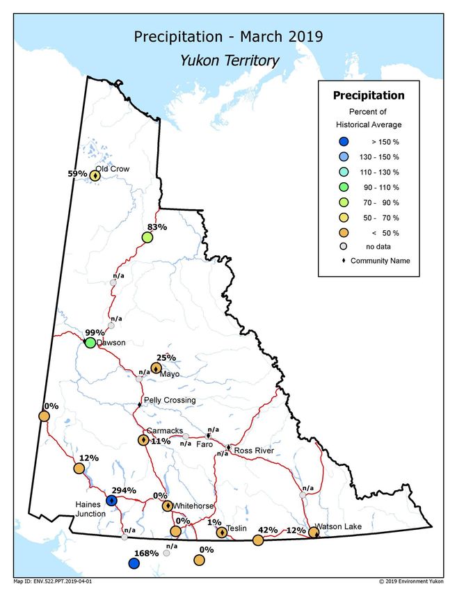
PREFACE
The Yukon Snow Survey Bulletin and Water Supply Forecast is prepared and issued three times annually – early March,
April and May – by the Department of Environment’s Water Resources Branch. The bulletin provides a summary of
winter meteorological and streamflow conditions for Yukon, as well as current snow depth and snow water equivalent
observations for 57 locations. This information is used to evaluate the potential for spring flooding caused by both
breakup ice jams and large spring snowmelt (freshet) flows. It is important to note that other processes such as summer
rain and glacier melt can significantly influence maximum annual water levels in specific Yukon basins.
The Snow Bulletin is presented in a new format and will continue to improve using new technologies and comments
provided by users and partners. The fall and winter average weather conditions (temperatures and precipitation) are
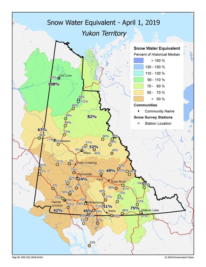
spatially presented for the entire territory in two figures. The spatial distribution of Snow Water Content (or Snow Water
Equivalent, SWE) is presented for 11 watersheds (or river basins) in a separate figure. Complementary meteorological
and hydrological data are presented for each basin through a maximum of five graphs, depending on data availability:
Figure A: Daily Snow Water Equivalent (SWE) data starting in September at one specific location in the
watershed, showing an overview of winter snowpack evolution.
Figure B: Current, basin averaged, estimated Snow Water Equivalent (SWE), from snow survey data, compared
with historical data, which represents an indicator of potential runoff volumes in the spring (considering that snow
sublimation, air temperatures, and rain also significantly affect runoff).
Figure C: Monthly-averaged precipitation (rain and/or snow), from meteorological stations, since October
compared with historical data (30-year climate normal), which complements the information presented in Figure B.
Figure D: Cumulated degree-days of freezing (CDDF, sum of negative daily temperatures) since October,
compared with historical data, that represents an indicator of winter coldness and overall river ice thickness which
affects river ice breakup scenarios in the spring.
Figure E: Current, estimated daily discharge or measured water level, compared with historical data, which
presents an overview of the watershed hydrological condition.
Information about the bulletin, snowpack conditions, or streamflow projections can be obtained by contacting:
Jonathan Kolot Anthony Bier Benoit Turcotte
Hydrology Technologist Hydrology Technologist Senior Scientist, Hydrology
(867) 667-3234 (867) 667-3144 (867) 667-3223
jonathan.kolot@gov.yk.ca anthony.bier@gov.yk.ca benoit.turcotte@gov.yk.ca
Water Resources Branch, Department of Environment
(867) 667-3171, toll free (in Yukon, NWT, Nunavut): 1-800-661-0408, ext. 3171
Fax: 867-667-3195 | Email: water.resources@gov.yk.ca
There were no changes to the network for 2019. This bulletin, as well as earlier editions, are available online at:
www.env.gov.yk.ca/snowbulletin
ISSN 1705-883X
It is recommended that reference to this report be made in the following form:
Yukon Snow Survey Bulletin and Water Supply Forecast, April 1, 2019
© April 2019
Water Resources Branch
Department of Environment
Government of Yukon
Box 2703, Whitehorse, Yukon Y1A 2C6
Yukon Snow Survey Bulletin and Water Supply Forecast April 1, 2019 3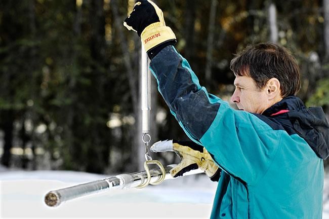
ACKNOWLEDGMENTS The Yukon Snow Survey Bulletin forms part of the Yukon Snow Survey Program administered by the Water Resources Branch, Department of Environment, Government of Yukon. Other agencies that contribute significantly to the Snow Survey Program by providing data, assistance and information for the bulletin are: Data Collection Officer, Natural Resources Conservation Service, United States Department of Agriculture Meteorologist, Wildland Fire Management, Yukon Department of Community Services, Whitehorse Officer in Charge, Water Survey of Canada, Whitehorse Water Management Engineer, Yukon Energy Corporation Vuntut Gwitchin First Nation McMaster University Agencies cooperating with Environment Yukon in the Snow Survey Program are: B.C. Ministry of Environment, Water Stewardship Division Parks Canada, Kluane National Park and Reserve Yukon Department of Highways and Public Works Yukon Department of Energy Mines and Resources, Compliance Monitoring and Inspections Branch Yukon Department of Environment, Information Management and Technology Branch Government of the Vuntut Gwitchin First Nation DISCLAIMER AND LIMITATION OF LIABILITY The User understands and acknowledges that the use of the data is solely at their own risk. The User is solely responsible for confirming the accuracy, availability, suitability, reliability, usability, completeness or timeliness of the data. The User accepts the data “as is” and acknowledges that the Government of Yukon makes no warranties or representations (express or implied) with respect to the accuracy, availability, suitability, reliability, usability, completeness or timeliness of the data, including, without limitation, implied warranties for merchantability, fitness for a particular purpose, and non-infringement. In consideration for access to the data, the User also agrees that in no event will the Government of Yukon be liable (in tort or contract) or responsible whatsoever to the User or any other legal entity for the accuracy, availability, suitability, reliability, usability, completeness or timeliness of the data, including, without limitation, any loss of revenue or profit, or for direct, indirect, special, incidental, or consequential damages arising from or related to the data. Yukon Snow Survey Bulletin and Water Supply Forecast April 1, 2019 4
YUKON TERRITORY WEATHER AND SNOWPACK CONDITIONS
Fall and winter 2018-19 was largely warmer than the historical average1 across the territory, with the
exception being a colder than average February in most of Yukon. Precipitation has been below to well below
historical average thanks to a combination of persistent blocking ridges and cold, dry arctic air.
December
Once again, temperatures fluctuated significantly as alternating warm ridges and cool artic air affected Yukon.
A warm spell early in the second week brought temperatures to above freezing as far north as Dawson City,
while an Arctic air mass brought cold temperatures to all areas just before Christmas. The month ended with
another bump to above freezing in southwest Yukon. Precipitation varied significantly, with the far north and
parts of southwest Yukon seeing above average amounts while the remainder of the territory was well below
average.

January
Early January brought extreme cold to central and northern Yukon with temperatures dropping to the mid-
minus-40s. Southern Yukon was variable, with another period of above freezing temperature to end the
month. Temperatures were once again above average across most of the territory, with only Mayo reporting
near historical average conditions. Precipitation was variable, with Old Crow at 150% of average, Whitehorse
at 120% and most remaining stations recording well below average, with a minimum of 8%.

February
February was characterized by cold, clear weather from both upper ridges and arctic outbreaks. Although
daytime highs often reached seasonal average, overnight lows ranged from mid-minus-20s to minus 40s.
With the exception of Old Crow and parts of the Dempster highway, February was 2-5 degrees cooler than
average. The mostly cool and clear conditions kept precipitation amounts low as well, with Whitehorse and
Teslin reaching close to historical average amounts thanks to a storm late in the month.

March
The transition to spring weather came nearly a month early to much of the territory, with very warm and in
many cases record-breaking daily high temperatures beginning early in the second week of March and
continuing through the end of the month. Warm daytime highs were exacerbated by overnight lows that
occasionally failed to drop below freezing, speeding the loss of the already thin snowpack in most of central
and southern Yukon. Temperatures were 5.8°C above normal, on average, for the month of March.
Precipitation was well below historical normal in central and south-central Yukon, near normal in Dawson and
Old Crow areas, and well above the climactic mean in Haines Junction and down to the Alaskan border, due
largely to a single large storm on March 18th.

1
  Historical temperature, precipitation, snow water equivalent and discharge or water level records are not always long
enough to establish a state-of-the-art “normal”, which implies 30 years of data. Therefore this document refers to
historical average, or more simply, average. Historical records considered in this bulletin are always long enough to be
representative of recent hydro-meteorological conditions.

    Yukon Snow Survey Bulletin and Water Supply Forecast April 1, 2019                                                5
Yukon Snow Survey Bulletin and Water Supply Forecast April 1, 2019 6
Yukon Snow Survey Bulletin and Water Supply Forecast April 1, 2019 7
Yukon Snow Survey Bulletin and Water Supply Forecast April 1, 2019 8
UPPER YUKON RIVER BASIN (SOUTHERN LAKES / WHITEHORSE)
At Wolf Creek Subalpine Station, Snow Water Equivalent (SWE) is measured to be 39% of the historical
average, well-below historical minimum (Figure A). The Upper Yukon basin-averaged SWE is estimated to
be 45% of the historical median, with 91 mm as of April 1 (Figure B).

Whitehorse Airport weather data during fall and winter shows a cumulative precipitation total near average
on March 1 whereas March precipitation was below average with 0 mm recorded (Figure C). Cumulative
degree-days of freezing (CDDF) are lower than average, with 1450 oC-Days, which indicates a mild winter
(Figure D). Warm weather in March has initiated an early CDDF decline and a thermal river ice breakup.

The measured water surface elevation (relative to sea level) in Marsh Lake is currently 0.3 m lower than the
historical average (Figure E). It is too early in the season to determine if 2019 will be a high water level year,
but the well-below average snowpack and low water levels suggest a very low potential for summer floods.

  Yukon Snow Survey Bulletin and Water Supply Forecast April 1, 2019                                          9
TESLIN RIVER BASIN
The Teslin River basin-averaged SWE is estimated to be 51% of the historical median, with 96 mm as of
April 1, setting a new record minimum (Figure B).

Teslin precipitation during fall and winter shows below average cumulative precipitation and a new record
low for the month of March with less than 1 mm (Figure C).

The measured water surface elevation (relative to sea level) in Teslin Lake is currently close to the historical
average (Figure E). It is too early in the season to determine if 2019 will be a high water level year, but the
well-below average snowpack and close to average water levels suggest a low potential for summer
floods.

 Yukon Snow Survey Bulletin and Water Supply Forecast April 1, 2019                                           10
CENTRAL YUKON RIVER BASIN (CARMACKS AREA)
The Central Yukon basin-averaged SWE is estimated to be 24% of the historical median, with 23 mm as of
April 1, setting a new record minimum (Figure B). Large portions of the Central Yukon Basin had no snow
cover on April 1.

Precipitation at Carmacks shows consistently lower than average monthly values during fall and winter,
including close to historical minimum in March (Figure C).

 Yukon Snow Survey Bulletin and Water Supply Forecast April 1, 2019                                      11
PELLY RIVER BASIN
The Pelly River basin-averaged SWE is estimated to be 49% of the historical median, with 72 mm as of
April 1, (Figure B).

Precipitation at Faro shows consistently lower than average monthly values during fall and winter (Figure C).
Precipitation values were not available for March in Faro, but Ross River registered 0 mm. Cumulated degree-
days of freezing (CDDF) are lower than average, with 2160 oC-Days, which indicates a mild winter
(Figure D). Warm weather in March has initiated an early CDDF decline and a thermal river ice breakup.

The estimated Pelly River discharge at Pelly Crossing is currently rising above the historical average as a
consequence of early snowmelt (Figure E). The well-below average snowpack suggests a lower than
average spring freshet volume. Spring peak flows will depend on residual snowmelt rates and rainfalls, but
there is currently a low potential for spring floods.

 Yukon Snow Survey Bulletin and Water Supply Forecast April 1, 2019                                      12
STEWART RIVER BASIN
At Withers Lake Meteorological station, Snow Water Equivalent (SWE) is measured to be 81% of the
historical average (Figure A). The Stewart River basin-averaged SWE is estimated to be 52% of historical
median, with 90 mm as of April 1, setting a new record minimum (Figure B).

Precipitation at Mayo Airport has been consistently lower than average for the fall and winter, including in the
month of March (Figure C). Cumulated degree-days of freezing (CDDF) are lower than average, with
2390 oC-Days, which indicates a mild winter (Figure D). Warm weather in March has initiated an early CDDF
decline and a thermal river ice breakup.

The estimated Stewart River discharge at the outlet has been rising well-above the historical average
(Figure E). The well-below average snowpack suggests a lower than average spring freshet volume. Spring
peak flows will depend on residual snowmelt rates and rainfalls, but there is currently a low potential for
spring floods.

 Yukon Snow Survey Bulletin and Water Supply Forecast April 1, 2019                                        13
WHITE RIVER BASIN
The White River basin-averaged SWE is estimated to be 71% of the historical median, with 56 mm as of
April 1 (Figure B).

The estimated White River discharge at the Alaska Highway is currently close to the historical average
(Figure E). High flows in this watershed are dominated by mountain snowmelt and glacial melt that are largely
influenced by summer temperatures and precipitations. The well-below average snowpack currently
suggests a lower than average spring and summer freshet volume.

 Yukon Snow Survey Bulletin and Water Supply Forecast April 1, 2019                                     14
LOWER YUKON RIVER BASIN (DAWSON AREA)
The Lower Yukon basin-averaged SWE is estimated to be 67% of the historical median, with 103 mm as of
April 1, setting a new historical minimum (Figure B).

Precipitation at Dawson Airport generally shows close to average monthly values during fall and winter,
including the month of March (Figure C). Cumulated degree-days of freezing (CDDF) are lower than average,
with 2710 oC-Days, which indicates a milder-than average winter (Figure D). Warm weather in March has
initiated a historically early CDDF decline and ice cover degradation in the Yukon and Klondike rivers.

The estimated Yukon River discharge is currently close to the historical average (Figure E). The well-below
average snowpack in all upstream basins suggests a low spring freshet volume. Spring peak flows will
depend on residual snowmelt rates and rainfalls, but there is currently a low potential for spring floods.
Spring breakup intensity in the Yukon River is currently forecasted to be low (to be updated regularly).

 Yukon Snow Survey Bulletin and Water Supply Forecast April 1, 2019                                      15
LIARD RIVER BASIN
The Liard River basin-averaged SWE is estimated to be 75% of the historical median, with 133 mm as of
April 1 (Figure B).

Precipitation at Watson Lake Airport shows overall lower than average monthly values during fall and winter,
including a well-below average month of March (Figure C).

The estimated Liard River discharge at Upper Liard is currently close to historical average (Figure E). The
below average snowpack and close to average discharge suggests a slightly lower than average spring
freshet volume. Spring peak flows will depend on residual snowmelt rates and rainfall, but there is currently
an average potential for spring floods.

 Yukon Snow Survey Bulletin and Water Supply Forecast April 1, 2019                                       16
ALSEK RIVER BASIN
The Alsek River basin-averaged SWE is estimated to be 42% of the historical median, with 54 mm as of
April 1, setting a new record minimum (Figure B).

Precipitation at Haines Junction showed consistently lower than average monthly winter values until March
when precipitation was well above average (Figure C). Most of this precipitation fell in the form of rain in low
elevation areas.

The estimated Alsek River discharge is currently well above the historical average (Figure E). High flows in
this watershed are dominated by mountain snowmelt and glacial melt that are largely influenced by summer
temperatures and precipitations. Therefore, the snow data presented above only provides a partial indicator of
potential summer flows.

 Yukon Snow Survey Bulletin and Water Supply Forecast April 1, 2019                                         17
PEEL RIVER BASIN
The Peel River basin-averaged SWE is estimated to be 82% of the historical median, with 114 mm as of
April 1 (Figure B).

The estimated Peel River discharge as of April 1st was above the historical maximum (Figure E). It is too early
in the season to determine if 2019 will be a high water level year, but the near average snowpack and current
hydrological conditions suggest a potentially average spring freshet volume. Spring peak flows will largely
depend on snowmelt rates and rainfall intensity, but there is currently an average potential for spring floods.

 Yukon Snow Survey Bulletin and Water Supply Forecast April 1, 2019                                       18
PORCUPINE RIVER BASIN
The Porcupine River basin-averaged SWE is estimated to be 108% of the historical median, with 140 mm as
of April 1 (Figure B).

Precipitation at Old Crow shows overall higher than average monthly values during fall and winter, but
slightly below average in the month of March (Figure C). Cumulated degree-days of freezing (CDDF) are well
below average, with 3190 oC-Days, which indicates a mild winter (Figure D). The river ice cover is probably
thinner than average and it has not started to degrade.

The estimated Porcupine River discharge is currently well above the historical average (Figure E). It is too
early in the season to determine if 2019 will be a high water level year, but the higher than average
snowpack and estimated discharge suggest a potentially above average spring freshet volume and peak
flows. It is too early to forecast spring breakup timing and intensity (updates will follow).

 Yukon Snow Survey Bulletin and Water Supply Forecast April 1, 2019                                        19
Drainage Basin and Snow Course
For Sample Date: 2019-03-01

                                                                     This
                                                                                  Water              Median
                                         Eleva-                      year                    Last                 Years
                                                      Date of                    content            Historical
        Name               Number         tion                      snow                     year                  of
                                                      survey                     (SWE)                SWE
                                          (m)                       depth                   (mm)                 record
                                                                                  (mm)                (mm)
                                                                     (cm)
Alsek River Basin
Canyon Lake             08AA-SC01        1160     3/26/2019        1.8           7         96       93           40
Alder Creek             08AA-SC02        768      3/27/2019        28            72        146      157          39
Aishihik Lake           08AA-SC03        945      3/26/2019        14            26        75       79           25
Haines Junction Farm    08AA-SC04        610      3/29/2019        0             0         76       96           19
Summit                  08AB-SC03        1000     3/29/2019        70            194       180      256          39
Yukon River Basin
Tagish                  09AA-SC01        1080     3/29/2019        26            64        160      147          43
Montana Mountain        09AA-SC02        1020     3/28/2019        20            53        144      142          42
Log Cabin (B.C.)        09AA-SC03        884      3/26/2019        65            228       285      376          59
Atlin (B.C)             09AA-SC04        730      3/27/2019        0             0         75       118          54
Mt McIntyre B           09AB-SC01B       1097     3/28/2019        36            91        182      157          43
Whitehorse Airport      09AB-SC02        700      3/26/2019        15            42        124      102          52
Meadow Creek            09AD-SC01        1235     3/27/2019        62            140       228      280          42
Jordan Lake             09AD-SC02        930      3/27/2019        24            49        121      137          32
Morley Lake             09AE-SC01        824      3/27/2019        22            46        126      149          31
Mount Berdoe            09AH-SC01        1035     3/28/2019        12            23        135      110          43
Satasha Lake            09AH-SC03        1106     3/28/2019        0             0         91       100          32
Williams Creek          09AH-SC04        914      3/28/2019        17            29        96       101          24
Twin Creeks B           09BA-SC02B       900      3/26/2019        39            92        123      121          3
Hoole River             09BA-SC03        1036     3/27/2019        25            50        133      139          42
Burns Lake              09BA-SC04        1112     3/27/2019        64            152       158      222          33
Finlayson Airstrip      09BA-SC05        988      3/27/2019        33            79        118      106          32
Fuller Lake             09BB-SC03        1126     3/26/2019        57            103       124      195          32
Russell Lake            09BB-SC04        1060     3/26/2019        63            150       193      228          32
Rose Creek              09BC-SC01        1080     3/28/2019        15            30        113      111          25
Mount Nansen            09CA-SC01        1021     3/28/2019        14            25        77       80           43
MacIntosh               09CA-SC02        1160     3/28/2019        0             0         105      99           43
Burwash Airstrip        09CA-SC03        810      3/27/2019        0             0         54       42           42
Beaver Creek            09CB-SC01        655      3/27/2019        24            51        113      86           44
Chair Mountain          09CB-SC02        1067     3/27/2019        31            61        153      100          29
Casino Creek            09CD-SC01        1065     3/28/2019        47            73        202      129          41
Pelly Farm              09CD-SC03        472      3/30/2019        1.4           6         106      79           33
Plata Airstrip          09DA-SC01        830      3/26/2019        34            92        139      188          41
Withers Lake            09DB-SC01        975      3/26/2019        55            152       170      229          33
Rackla Lake             09DB-SC02        1040     3/26/2019        61            153       124      189          32

Code "E" - Estimate, Code "B" - Survey date is outside of valid sampling range

  Yukon Snow Survey Bulletin and Water Supply Forecast April 1, 2019                                                  20
Drainage Basin and Snow Course
For Sample Date: 2019-03-01
Name Number Eleva Date of This Water Last Water Years
-tion survey year conten year content of
(m) snow t (mm) (mm) averag record
depth e
(cm)
Yukon River Basin
Mayo Airport A 09DC-SC01A 540 3/28/2019 0 0 56 96 49
Mayo Airport B 09DC-SC01B 540 3/28/2019 0 0 64 103 31
Edwards Lake 09DC-SC02 830 3/26/2019 37 68 109 160 32
Calumet 09DD-SC01 1310 3/29/2019 44 95 E 172 195 40
King Solomon Dome 09EA-SC01 1080 3/29/2019 39 83 172 163 43
Grizzly Creek 09EA-SC02 975 4/1/2019 57 119 161 178 43
Midnight Dome 09EB-SC01 855 3/28/2019 49 109 161 154 44
Boundary (Alaska) 09EC-SC02 1005 3/28/2019 48 122 137 136 48
Porcupine River Basin
Riff's Ridge 09FA-SC01 650 4/1/2019 59 132 165 148 31
Eagle Plains 09FB-SC01 710 4/1/2019 77 185 178 166 35
Eagle River 09FB-SC02 340 4/1/2019 70 132 172 138 34
Old Crow 09FD-SC01 299 3/27/2019 71 140 130 E 120 37
Liard River Basin
Watson Lake Airport 10AA-SC01 685 3/28/2019 30 77 120 139 54
Tintina Airstrip 10AA-SC02 1067 3/27/2019 62 139 183 206 41
Pine Lake Airstrip 10AA-SC03 995 3/27/2019 54 144 172 223 43
Ford Lake 10AA-SC04 1110 3/27/2019 61 113 191 192 32
Frances River 10AB-SC01 730 3/27/2019 42 105 88 159 44
Hyland River 10AD-SC01 855 3/29/2019 56 148 121 177 42
Hyland River B 10AD-SC01B 880 3/29/2019 60 165 131 131 1
Peel River Basin
Blackstone River 10MA-SC01 920 4/1/2019 35 72 123 106 43
Ogilvie River 10MA-SC02 595 4/1/2019 51 102 E 102 107 41
Bonnet Plume Lake 10MB-SC01 1120 3/26/2019 54 109 125 178 32
Alaska Snow Courses
Eaglecrest 08AK-SC01 305 4/2/2019 51 163 203 495 37
Moore Creek Bridge 08AK-SC02 700 1/4/2019 76 269 191 517 26
Code "E" - Estimate, Code "B" - Survey date is outside of valid sampling range
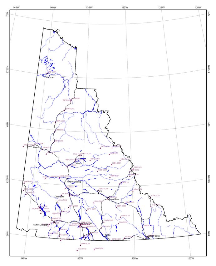
Yukon Snow Survey Bulletin and Water Supply Forecast April 1, 2019 21Location of water resource snow courses Yukon Snow Survey Bulletin and Water Supply Forecast April 1, 2019 22
You can also read