YUKON SNOW SURVEY BULLETIN & WATER SUPPLY FORECAST - May 1, 2021 - Prepared and issued by: Water Resources Branch Department of Environment ...
←
→
Page content transcription
If your browser does not render page correctly, please read the page content below
YUKON SNOW SURVEY
BULLETIN & WATER
SUPPLY FORECAST
May 1, 2021

                       Prepared and issued by:
                      Water Resources Branch
                    Department of Environment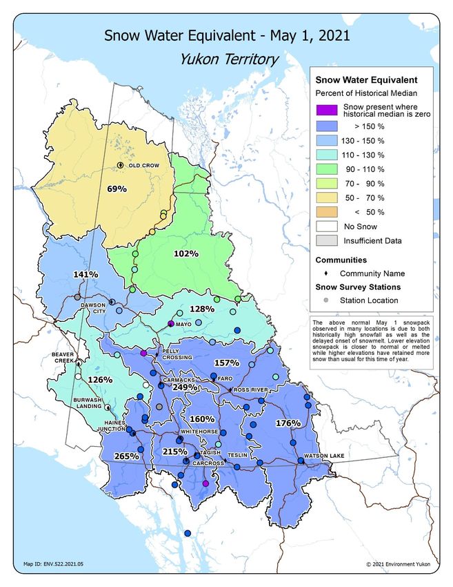
PREFACE
The Department of Environment’s Water Resources Branch issues the Yukon Snow Survey Bulletin and Water Supply
Forecast three times annually – early March, April and May. The bulletin provides a summary of winter meteorological
and streamflow conditions for Yukon, as well as current snow depth and snow water equivalent observations for 57
locations. This information is used to evaluate the potential for spring flooding caused by both breakup ice jams and large
spring snowmelt (freshet) flows. It is important to note that other processes such as summer rain and glacier melt can
significantly influence maximum annual water levels in specific Yukon basins.
April weather conditions for Yukon are presented in two maps, one showing temperature anomalies (deviation from
climate normals), and another showing precipitation anomalies. Territory-wide snowpack data are presented in a third
map showing snow water equivalent (SWE) as a percent of historical median for each station, as well as the basin-
averaged estimated SWE for 11 watersheds (or river basins). Complementary meteorological and hydrological data are
presented for each basin through a series of five graphs, depending on data availability:
Figure A: Cumulative Snow Water Equivalent (SWE) data over the course of the winter at one specific location in
the watershed, showing an overview of winter snowpack evolution.
Figure B: Current, basin-averaged, estimated Snow Water Equivalent (SWE) from snow survey data, compared
with historical data, serving as an indicator of potential runoff volumes in the spring (acknowledging that snow
sublimation, evapotranspiration, rain and glacier melt also significantly affect runoff).
Figure C: Monthly winter precipitation (rain and/or snow) compared with historical data (1980-2020 period of
record) from a specific climate station in the watershed, complementing the information presented in Figure B.
Figure D: Cumulative degree-days of freezing (CDDF, sum of negative daily temperatures) compared with
historical data, functioning as an indicator of winter coldness and overall river ice thickness.
Figure E: Current, estimated daily discharge or measured water level, compared with historical data.
Information about the bulletin, snowpack conditions, or streamflow projections can be obtained by contacting:
Jonathan Kolot Alexandre Mischler Anthony Bier Holly Goulding
Hydrology Technologist Hydrology Technologist Intermediate Hydrologist Senior Hydrologist
(867) 667-3234 (867) 667-3144 (867) 667-5029 (867) 667-3223
jonathan.kolot@yukon.ca alexandre.mischler@yukon.ca anthony.bier@yukon.ca holly.goulding@yukon.ca
Water Resources Branch, Department of Environment
(867) 667-3171, toll free (in Yukon, NWT, Nunavut): 1-800-661-0408, ext. 3171
Fax: 867-667-3195 | Email: water.resources@yukon.ca
This bulletin, as well as earlier editions, are available online at:
https://yukon.ca/snow-surveys-and-water-supply-forecasts#snow-and-water-supply-data
Historical data in .csv format are available online at:
https://open.yukon.ca/data/datasets/yukon-snow-survey-network
ISSN 1705-883X
Reference to this report should be made in the following form:
Yukon Snow Survey Bulletin and Water Supply Forecast, May 1, 2021
© May 2021
Water Resources Branch
Department of Environment
Government of Yukon
Box 2703, Whitehorse, Yukon Y1A 2C6
Yukon Snow Survey Bulletin and Water Supply Forecast May 1, 2021 2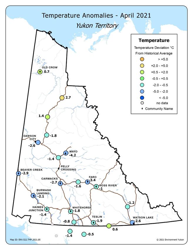
ACKNOWLEDGMENTS
The Yukon Snow Survey Bulletin forms part of the Yukon Snow Survey Program administered by the Water Resources
Branch, Department of Environment, Government of Yukon. Other agencies that contribute significantly to the Snow
Survey Program by providing data, assistance and information for the bulletin are:
Data Collection Officer, Natural Resources Conservation Service, United States Department of Agriculture
Meteorologist, Wildland Fire Management, Government of Yukon Department of Community Services
Officer in Charge, Water Survey of Canada, Whitehorse
Water Management Engineer, Yukon Energy Corporation
Agencies cooperating with the Government of Yukon’s Department of Environment in the Snow Survey Program are:
B.C. Ministry of Environment, Water Stewardship Division
Parks Canada, Kluane National Park and Reserve
Government of Yukon Department of Highways and Public Works
Government of Yukon Department of Energy Mines and Resources, Compliance Monitoring and Inspections
Branch
Government of Yukon Department of Environment, Information Management and Technology Branch
Government of the Vuntut Gwitchin First Nation
McMaster University
DISCLAIMER AND LIMITATION OF LIABILITY
The User understands and acknowledges that the use of the data is solely at their own risk. The User is solely
responsible for confirming the accuracy, availability, suitability, reliability, usability, completeness or timeliness of the
data.
The User accepts the data “as is” and acknowledges that the Government of Yukon makes no warranties or
representations (express or implied) with respect to the accuracy, availability, suitability, reliability, usability,
completeness or timeliness of the data, including, without limitation, implied warranties for merchantability, fitness for a
particular purpose, and non-infringement.
In consideration of access to the data, the User also agrees that in no event will the Government of Yukon be liable (in
tort or contract) or responsible whatsoever to the User or any other legal entity for the accuracy, availability, suitability,
reliability, usability, completeness or timeliness of the data, including, without limitation, any loss of revenue or profit, or
for direct, indirect, special, incidental, or consequential damages arising from or related to the data.
Yukon Snow Survey Bulletin and Water Supply Forecast May 1, 2021 3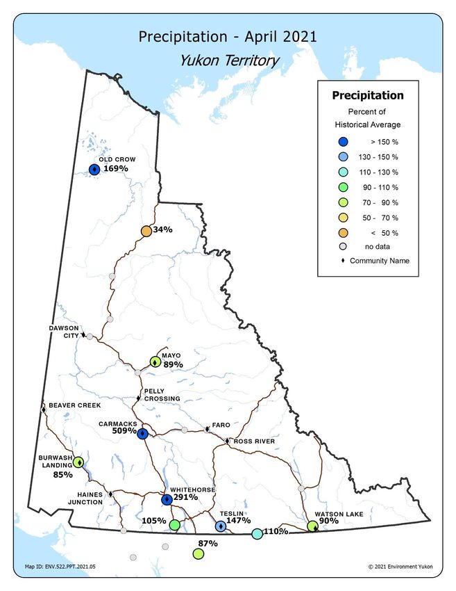
YUKON TERRITORY WEATHER AND SNOWPACK CONDITIONS
Fall and winter 2020-21 temperatures varied greatly from month to month. Generally, the months of October,
November, February, and March were colder than the historical average1 in most regions of the territory while
December and January were warmer than the historical average. Precipitation anomalies were substantial in
November, December, February and March, with some regional contrasts between the much wetter
conditions in the south and a drier winter in the far north. Heavy snowfall in November set the stage for above
normal snowpack conditions observed in the majority of the territory.
October
October was drier than normal in southeastern, southwestern, and northern Yukon while the Carmacks region
received more precipitation than normal. Temperatures were two to three degrees colder than normal for
central and southern Yukon and slightly warmer than normal in Old Crow.

November
The beginning of the month saw significant precipitation in southern and central Yukon with likely record-
breaking snowfall in Whitehorse on November 2 (also high snowfall in Carcross, Atlin, Teslin, Dawson, Mayo,
& Watson Lake). Monthly average temperatures were two to four degrees colder than normal for much of the
territory. By contrast, there was lower than average precipitation and close to normal temperatures in the far
north (Old Crow, Eagle Plains) and the northern Kluane region (Beaver Creek and Burwash Landing).

December
December began with the incursion of an atmospheric river in southwestern Yukon; following substantial
snowfall on December 1, unseasonably warm weather and rain resulted in significant snowmelt. Whitehorse
and Carcross reported more than twice the normal amount of precipitation for December and a winter storm
on December 14 brought closures to both the Haines and White Passes. By contrast, northern regions were
drier than normal in December. Temperatures were substantially warmer than normal across all of south and
central Yukon from Watson Lake to Beaver Creek to Stewart Crossing. Northern regions experienced slightly
above normal temperatures.

January
Most areas of Yukon received less precipitation than normal in January. Only Carcross and Haines Junction
stations reported more precipitation than normal. A January 18 winter storm closed both the Haines and
White Passes as well as the Alaska Highway on January 19. January saw a continuation of the much warmer
than normal weather throughout Yukon, with temperatures ranging from four to seven degrees above normal.

February
Precipitation varied throughout Yukon in February. Some areas in south and central Yukon reported well
above normal precipitation. February 21-22 brought an atmospheric river that resulted in a multi-day closure
of the White and Haines Passes. The far north region was drier than normal. February was, overall, colder
than normal with stations reporting temperatures ranging from four to eight degrees below normal.

1
  Historical temperature, precipitation, snow water equivalent and discharge or water level records are not always long
enough to establish a state-of-the-art “normal”, which implies 30 years of data. Therefore, this document refers to
historical average, or more simply, average. Historical records considered in this bulletin are always long enough to be
representative of recent hydro-meteorological conditions.

    Yukon Snow Survey Bulletin and Water Supply Forecast May 1, 2021                                                  4
March
Most weather stations recorded wetter than normal conditions in March. Precipitation in the Southern Lakes
region and Teslin Lake drainage were above to well above normal. Precipitation anomalies were also high in
Central Yukon. Farther North, Eagle Plains was much drier, while Old Crow was slightly wetter than normal.
March was slightly colder than normal across the territory, two degrees below normal on average. The Kluane
region and Mayo had more pronounced temperature anomalies, four degrees below normal in both areas.

April
April is typically a dry month in Yukon, which means precipitation anomalies are amplified. While some parts
of the territory were close to or slightly drier than normal, Carmacks and Whitehorse were significantly wetter
than normal, mostly due to heavy snowfall early in the month and then rainfall on April 29-30. Precipitation in
Old Crow and Teslin was also above normal. Temperatures were colder than normal except in the far north,
with the first two weeks of the month significantly colder than normal, while the latter half of April had closer
to normal temperatures. On average, central Yukon was more than two degrees colder than normal.

Snowpack
Above normal snowpack conditions were observed on May 1 in many locations due to both historically high
snowfall over the winter, as well as a delayed onset of snowmelt. Lower elevation snowpack is closer to
normal or melted while higher elevations have retained more snow than usual for this time of year. Once
again, the Upper Yukon River Basin had the highest basin-averaged estimated snowpack for this time of year.
The Central Yukon River Basin (Carmacks area) had record April precipitation combined with delayed melt,
resulting in a significant snowpack for this time of year. Snowpack anomalies also increased in the Alsek,
Liard, Teslin, Pelly, Lower Yukon (Dawson area) and Stewart River Basins.

YUKON TERRITORY FLOW CONDITIONS AND OUTLOOK
River discharge went from above average winter flow to below average flow for this time of year in many
rivers as the cold spring delayed the initiation of snowmelt, especially at higher elevations.

Breakup was actively occurring across the territory at the time of writing, and was of low to moderate
intensity in most locations, moderated by cooler temperatures in late April that slowed the rate of melt and
runoff after the initial onset of snowmelt in mid-April. This allowed more time for ice degradation prior to
breakup and reduced the potential severity of ice jam flooding. Ice cover degradation is just beginning on the
Porcupine River, and breakup is expected in the coming weeks.

Peak spring freshet flows are expected to be above average in most regions. Above to well above median
peak snowpack in southern and central Yukon this winter, combined with the delayed melt of higher elevation
snow, means that considerable snow remained on May 1. Above seasonal air temperatures or significant
rainfall events are likely to generate high runoff rates, resulting in significant May and June peak flows in
streams and rivers.

Weather conditions over the rest of spring and summer will influence peak flows and lake levels in
watersheds influenced by glacial melt, including the Southern Lakes in the Upper Yukon River Basin. Warm
and/or wet weather anomalies during the next three months are likely to generate high peak flows and lake
levels in these basins.

  Yukon Snow Survey Bulletin and Water Supply Forecast May 1, 2021                                           5
MAP 1. TEMPERATURE ANOMALIES

 Yukon Snow Survey Bulletin and Water Supply Forecast May 1, 2021   6
MAP 2. PRECIPITATION

 Yukon Snow Survey Bulletin and Water Supply Forecast May 1, 2021   7
MAP 3. SNOW WATER EQUIVALENT

 Yukon Snow Survey Bulletin and Water Supply Forecast May 1, 2021   8
UPPER YUKON RIVER BASIN (SOUTHERN LAKES / WHITEHORSE)
At Wolf Creek Subalpine Station, Snow Water Equivalent (SWE) is estimated to be 270% of the historical
average (Figure A1), while at Tagish Station, SWE is estimated to be 169% of the historical average (Figure
A2). It should be noted that in high snowpack years such as this, the Wolf Creek snow pillow is subject to
drifting events that may result in it reporting higher SWE compared to actual precipitation. The Upper Yukon
basin-averaged SWE is estimated to be 215% of the historical median, with 327 mm on May 1 (Figure B).
This is the highest basin snowpack estimate on record for this time of year.

Precipitation at Whitehorse Airport for the month of April was well above average (Figure C), resulting in
total winter precipitation being well above average on May 1. Cumulative degree-days of freezing (CDDF) are
close to average, with 1870 oC-Days as of May 1 (Figure D). Ice cover on most rivers and streams is now
mostly gone and lakes will gradually follow.

  Yukon Snow Survey Bulletin and Water Supply Forecast May 1, 2021                                       9
The measured water surface elevation (relative to sea level) in Marsh Lake is currently close to average
(Figure E). Water levels in the Southern Lakes are driven by a combination of snowmelt, summer precipitation
and glacier melt. Current snow conditions suggest that water levels will be higher than average this summer.
Weather conditions will determine peak summer water level. Warm and/or wet weather anomalies during the
next three months are likely to generate high peak summer water levels.

 Yukon Snow Survey Bulletin and Water Supply Forecast May 1, 2021                                      10
TESLIN RIVER BASIN
The Teslin River basin-averaged SWE is estimated at 160% of the historical median, with 257 mm on May 1
(Figure B). This is considered a significant snowpack for this time of year.

Teslin precipitation for the month of April was above average (Figure C), with total winter precipitation being
above average on May 1.

The measured water surface elevation (relative to sea level) in Teslin Lake is currently close to average
(Figure E). The higher than median snowpack and the close to average water level suggest that summer
water levels will be higher than average. Peak water levels will depend on spring weather patterns. Warm
and/or wet weather will generate high runoff rates and water levels, including in rivers and streams crossing
the Alaska Highway and the South Canol Road.

 Yukon Snow Survey Bulletin and Water Supply Forecast May 1, 2021                                          11
CENTRAL YUKON RIVER BASIN (CARMACKS AREA)
The Central Yukon basin-averaged SWE is estimated to be 249% of the historical median, with 107 mm on
May 1 (Figure B). This is considered a significant snowpack for this time of year.

Heavy snowfall on April 1 and heavy rainfall on April 30 in Carmacks resulted in historically high monthly
precipitation (Figure C), with total winter precipitation being above average on May 1.

Water levels in Carmacks area rivers are expected be higher than average this spring and summer.

 Yukon Snow Survey Bulletin and Water Supply Forecast May 1, 2021                                            12
PELLY RIVER BASIN
At Twin Creeks weather station, Snow Water Equivalent (SWE) is estimated to be 195% of the historical
average (Figure A). The Pelly River basin-averaged SWE is estimated to be 157% of the historical median,
with 183 mm as of May 1 (Figure B). This is considered a significant snowpack for this time of year.

Precipitation at Faro has not been recorded, but snowpack observations indicate values are above average.
Cumulative degree-days of freezing (CDDF) at Faro are slightly above average at 2670 oC-Days (Figure D),
River ice breakup is nearly complete in the Pelly River.

The estimated Pelly River discharge at Pelly Crossing is currently above average (Figure E). The higher than
normal snowpack in the watershed increases the probability of high May and June peak flows, including in
rivers and streams crossing the Robert Campbell Highway and Canol Road.

 Yukon Snow Survey Bulletin and Water Supply Forecast May 1, 2021                                        13
STEWART RIVER BASIN
At Withers Lake Meteorological station, Snow Water Equivalent (SWE) is estimated to be 102% of the
historical average (Figure A). The Stewart River basin-averaged SWE is estimated to be 128% of historical
median, with 199 mm as of May 1 (Figure B). This is considered an above normal snowpack for this time of
year.

Precipitation at Mayo Airport for the month of April was close to average (Figure C), with total winter
precipitation being close to average on May 1. Cumulative degree-days of freezing (CDDF) are above
average, with 3065 oC-Days (Figure D). River ice breakup is nearly complete in the Stewart River.

The estimated Stewart River discharge at the outlet is currently close to average (Figure E). The above
median snowpack in the watershed increases the probability of above average May and June peak flows.

 Yukon Snow Survey Bulletin and Water Supply Forecast May 1, 2021                                         14
WHITE RIVER BASIN
The White River basin-averaged SWE is estimated to be 126% of the historical median, with 53 mm as of
May 1 (Figure B). The low elevation snowpack was greatly depleted in April but snowpack remains significant
at higher elevations.

The estimated White River discharge at the Alaska Highway is currently close to average (Figure E), due in
part to the later than normal initiation of snowmelt. In this watershed, high flows are dominated by mountain
snowmelt and glacial melt that are largely influenced by summer temperatures and precipitation. The above
median snowpack is likely to generate higher than average freshet volumes. Warm and/or wet weather
anomalies during the next three months are likely to generate high peak flows, including in rivers and streams
crossing the Alaska Highway in the Kluane region.

 Yukon Snow Survey Bulletin and Water Supply Forecast May 1, 2021                                        15
LOWER YUKON RIVER BASIN (DAWSON AREA)
The Lower Yukon basin-averaged SWE is estimated to be 141% of the historical median, with 168 mm as of
May 1 (Figure B). This is considered an above normal snowpack for this time of year.

The precipitation recorded at Dawson Airport (Figure C) is suspected to be in error due to a malfunctioning
gauge. Cumulative degree-days of freezing (CDDF) are above average, with 3500 oC-Days (Figure D).
Breakup on the Klondike River and Yukon River at Dawson occurred in early May.

The estimated Yukon River discharge at the White River is close to average (Figure E), due in part to the later
than normal initiation of snowmelt. The well above median snowpack in all upstream basins suggests a high
potential for significant spring freshet flows. This also applies to the Klondike River where above median
snow conditions also present the potential for high freshet flows.

 Yukon Snow Survey Bulletin and Water Supply Forecast May 1, 2021                                          16
LIARD RIVER BASIN
At Hyland meteorological station, Snow Water Equivalent (SWE) is estimated to be 384% of the historical
average (Figure A). The Liard River basin-averaged SWE is estimated to be 176% of the historical median,
with 234 mm as of May 1 (Figure B). This is considered a significant snowpack for this time of year.

April precipitation at Watson Lake Airport was slightly above average (Figure C), with total winter
precipitation being near average on May 1, but this only applies to the southern portion of the Liard
watershed. Concurrent snowpack measurements taken in April at the Watson Lake Airport meteorological
station and snow survey course suggest that the precipitation gauge likely underestimated snowfall this
winter.

The estimated Liard River discharge at Upper Liard is currently near average (Figure E). The well above
median snowpack in the watershed increases the probability of high spring freshet flows, both in the Liard
River and in rivers and streams crossing the Alaska Highway and Robert Campbell Highway.

 Yukon Snow Survey Bulletin and Water Supply Forecast May 1, 2021                                       17
ALSEK RIVER BASIN
The Alsek River basin-averaged SWE is estimated to be 265% of the historical median, with 172 mm as of
May 1 (Figure B). These data are from the Kluane and Aishihik Lake areas while the snowpack in the St. Elias
Range may be higher compared to the historical median. This is considered a significant snowpack for this
time of year.

The estimated Alsek River discharge is currently above average (Figure E). Peak flows in this watershed are
dominated by mountain snowmelt and glacial melt that are largely influenced by summer temperatures and
precipitation. The well above median snowpack is likely to generate significantly higher than average
freshet volumes. Warm and/or wet weather anomalies during the next three months are likely to generate
high peak flows.

 Yukon Snow Survey Bulletin and Water Supply Forecast May 1, 2021                                        18
PEEL RIVER BASIN
The Peel River basin-averaged SWE is estimated to be 102% of the historical median, with 117 mm on
May 1 (Figure B). This is considered a normal snowpack for this time of year.

The estimated Peel River discharge is below average (Figure E), due in part to the later than normal initiation
of snowmelt. The near median snowpack suggests close to average freshet flows are likely. Significant
temperature or rainfall anomalies could still generate high peak flows this spring and summer, including in
rivers and streams crossing the Dempster Highway.

 Yukon Snow Survey Bulletin and Water Supply Forecast May 1, 2021                                          19
PORCUPINE RIVER BASIN
The Porcupine River basin-averaged SWE is estimated to be 69% of the historical median, with 77 mm on
May 1 (Figure B). This is considered a lower than normal snowpack for this time or year.

Old Crow precipitation for the month of April was above average (Figure C). However, total winter
precipitation was below average because of dry conditions from October to December and in February.
Cumulative degree-days of freezing (CDDF) are average, with 4315 oC-Days as of May 1 (Figure D). While
this suggests a normal ice cover thickness on lakes and rivers in the region, there are local reports of above
average ice thickness on parts of the Porcupine River. Ice cover degradation is just beginning.

The estimated Porcupine River discharge is below average following recent measurements (Figure E). With
the below average snowpack, spring freshet flows are likely to be below average. Prior to that, a sudden
sustained rise in air temperature could be conducive to ice jamming.

 Yukon Snow Survey Bulletin and Water Supply Forecast May 1, 2021                                           20
DRAINAGE BASIN AND SNOW COURSE
For Sample Date: 2021-05-01

                                                                      This
                                                                                Water                  Median
                                          Eleva-                      year                  Last                    Years
                                                      Date of                  content                Historical
Name                        Number         tion                      snow                   year                     of
                                                      survey                   (SWE)                    SWE
                                           (m)                       depth                 (mm)                    record
                                                                                (mm)                    (mm)
                                                                      (cm)
Alsek River Basin
Canyon Lake             08AA-SC01         1160      2021-04-27         32         88        39           34         43
Alder Creek             08AA-SC02          768      2021-04-27         58        183        60           66         39
Aishihik Lake           08AA-SC03          945      2021-04-27         28         82       8E            32         27
Haines Junction Farm    08AA-SC04          610      2021-04-29         37        128         0           14         20
Summit                  08AB-SC03         1000      2021-04-29        112        421       157          190         39
Yukon River Basin
Tagish                  09AA-SC01         1080      2021-04-29         69        178        94          114         45
Montana Mountain        09AA-SC02         1020      2021-04-28         74        219        92          120         44
Log Cabin (B.C.)        09AA-SC03          884      2021-04-26        183        761       430          353         60
Atlin (B.C)             09AA-SC04          730      2021-04-27         50        153         0            0         53
Mt McIntyre B           09AB-SC01B        1097      2021-04-27         83        226       164          140         45
Whitehorse Airport      09AB-SC02          700      2021-04-26         39        147        16            4         54
Meadow Creek            09AD-SC01         1235      2021-04-27        126        346       346          280         45
Jordan Lake             09AD-SC02          930      2021-04-29         65        184       161           92         32
Morley Lake             09AE-SC01          824      2021-04-26         58        224        56           76         33
Mount Berdoe            09AH-SC01         1035      2021-04-27         56        137       104           49         45
Satasha Lake            09AH-SC03         1106         N.S.           N.S.       N.S.       61           13         32
Williams Creek          09AH-SC04          914      2021-04-27         44         94        67           26         24
Twin Creeks A           09BA-SC02A         900      2021-04-29         71        206       N.S.         150         40
Twin Creeks B           09BA-SC02B         900      2021-04-29         61        165       167          115          5
Hoole River             09BA-SC03         1036      2021-04-29         80        239       164           90         44
Burns Lake              09BA-SC04         1112      2021-04-29         91        283       304          225         35
Finlayson Airstrip      09BA-SC05          988      2021-04-29         51        165       116           51         34
Fuller Lake             09BB-SC03         1126      2021-04-28         93        245       228          213         35
Russell Lake            09BB-SC04         1060      2021-04-28         99        289       260          219         34
Rose Creek              09BC-SC01         1080      2021-04-30         48        135        69           22         26
Mount Nansen            09CA-SC01         1021      2021-04-27          0          0        54            0         44
MacIntosh               09CA-SC02         1160      2021-04-27         31         88        89           34         43
Burwash Airstrip        09CA-SC03          810      2021-04-28          0          0         0            0         40
Beaver Creek            09CB-SC01          655      2021-04-28          0          0         0            0         44
Chair Mountain          09CB-SC02         1067      2021-04-28          0          0       N.S.           0         13
Casino Creek            09CD-SC01         1065      2021-04-27         61        153       175          121         43
Pelly Farm              09CD-SC03          472      2021-04-28         22         64        57            0         35
Plata Airstrip          09DA-SC01          830      2021-04-28         84        250       195          148         42
Withers Lake            09DB-SC01          975      2021-04-28         84        245       291          220         35
Rackla Lake             09DB-SC02         1040      2021-04-28         82        200       259          199         34

Code "E" - Estimate, Code "B" - Survey date is outside of valid sampling range, “N.S.” – No survey.

  Yukon Snow Survey Bulletin and Water Supply Forecast May 1, 2021                                                    21
DRAINAGE BASIN AND SNOW COURSE
For Sample Date: 2021-05-01
This
Water Median
Eleva- year Last Years
content Historical
Name Number tion Date of survey snow year of
(SWE) SWE
(m) depth (mm) record
(mm) (mm)
(cm)
Yukon River Basin
Mayo Airport A 09DC-SC01A 540 2021-04-29 20 54 103 E 0 50
Mayo Airport B 09DC-SC01B 540 2021-04-29 0 0 113 E 0 33
Edwards Lake 09DC-SC02 830 2021-04-28 84 221 172 149 34
Calumet 09DD-SC01 1310 2021-04-29 89 200 229 176 40
King Solomon
09EA-SC01 1070 2021-04-28 52 173 242 128 45
Dome
Grizzly Creek 09EA-SC02 975 2021-04-27 57 130 192 137 45
Midnight Dome 09EB-SC01 855 2021-04-28 71 201 257 140 46
Boundary (Alaska) 09EC-SC02 1005 N.S N.S N.S N.S. N.S. N.S
Porcupine River Basin
Riff's Ridge 09FA-SC01 650 2021-04-27 42 91 180 137 33
Eagle Plains 09FB-SC01 710 2021-04-27 38 95 209 147 35
Eagle River 09FB-SC02 340 2021-04-27 45 94 160 108 35
Old Crow 09FD-SC01 299 2021-04-29 38 64 158 102 35
Liard River Basin
Watson Lake
10AA-SC01 685 2021-04-28 37 96 18 19 56
Airport
Tintina Airstrip 10AA-SC02 1067 2021-04-29 96 297 297 190 44
Pine Lake Airstrip 10AA-SC03 995 2021-04-26 93 300 274 196 45
Ford Lake 10AA-SC04 1110 2021-04-29 95 275 308 172 33
Frances River 10AB-SC01 730 2021-04-28 63 147 88 78 45
Hyland River 10AD-SC01 855 2021-04-27 78 246 233 112 44
Hyland River B 10AD-SC01B 880 2021-04-27 86 267 271 132 3
Peel River Basin
Blackstone River 10MA-SC01 920 2021-04-27 48 94 125 73 44
Ogilvie River 10MA-SC02 595 2021-04-27 51 87 115 85 43
Bonnet Plume Lake 10MB-SC01 1120 2021-04-28 80 198 238 191 35
Alaska Snow Courses
Eaglecrest 08AK-SC01 305 2021-05-03 196 658 554 361 35
Moore Creek
08AK-SC02 700 2021-05-01 178 803 N.S. 507 24
Bridge
Code "E" - Estimate, Code "B" - Survey date is outside of valid sampling range, “N.S.” – No survey.
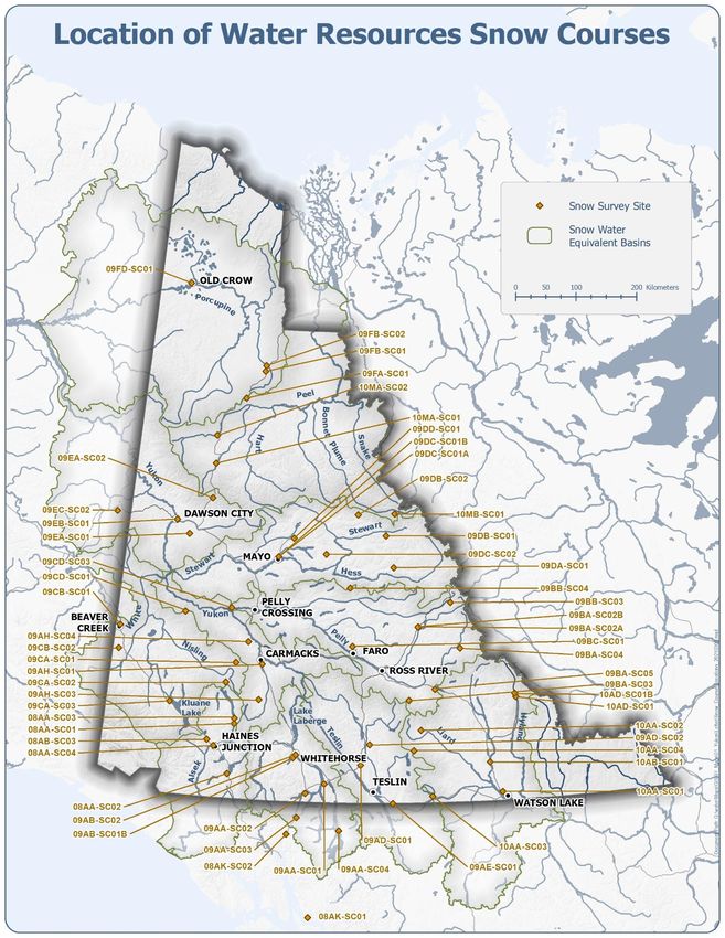
Yukon Snow Survey Bulletin and Water Supply Forecast May 1, 2021 22MAP 4. LOCATION OF WATER RESOURCES SNOW COURSES Yukon Snow Survey Bulletin and Water Supply Forecast May 1, 2021 23
You can also read