British Columbia Earthquake Fact Sheet - Outline: Engineers and ...
←
→
Page content transcription
If your browser does not render page correctly, please read the page content below
Structural Engineers Association of B.C.

British Columbia Earthquake Fact Sheet
Outline:

   1.   Overview of BC Seismicity
   2.   Earthquake effects on buildings
   3.   Performance criteria for buildings
   4.   Performance of non-structural elements
   5.   What should you do?
            a. As a homeowner
            b. As a current owner/occupier of an existing building
            c. As a future developer /owner of a new building

1. Overview of BC Seismicity

Each year, seismologists with the Geological Survey of Canada record and locate more than
2500 earthquakes in western Canada. The Pacific Coast is the most earthquake-prone region of
Canada. In the offshore region to the west of Vancouver Island, more than 100 earthquakes of
magnitude 5 or greater (large enough to cause damage had they been closer to land) have
occurred during the past 70 years. Part of the Pacific Ring of Fire, the concentration of
earthquakes along the west coast is related to the presence of active faults, or breaks in the
earth's crust. The surface of the earth is always changing, as the earth's crust is made up of
"plates" (like pieces of a jigsaw puzzle) that are constantly moving relative to one another at
speed's of about 2-10 cm/year (about how fast your fingernails grow). The plates can either
slide past one another, or they can collide, or they can diverge (move apart).

The west coast of Canada is one of the few areas in the world where all three of these types of
plate movements take place, resulting in significant earthquake activity. Earthquakes in this
region occur along the faults in the offshore region (e.g., the M=8.1 Queen Charlotte Island
earthquake of 1949); within the subducting ocean plate (e.g., a magnitude 6.8 earthquake
beneath the Seattle-Tacoma region in 2001); and within the continental crust (e.g., a magnitude
7.3 earthquake on central Vancouver Island in 1946). Moving inland from the coast (and the

                                                                                    Page 1 of 12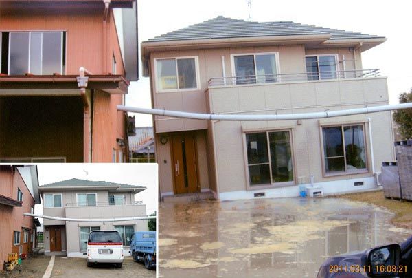
active plate boundaries), the frequency and size of the earthquakes decreases. Saskatchewan
and Manitoba are the least earthquake-prone areas in Canada.

Offshore Region

From northern Vancouver Island, to Haida Gwaii, the oceanic Pacific plate is sliding to the
northwest at about 6 cm/year relative to North America. The boundary between these two
giant plates is the Queen Charlotte fault - Canada's equivalent of the San Andreas fault.
Canada's largest historical earthquake- a magnitude 8.1, occurred along this fault on August 22,
1949. This earthquake, larger than the 1906 San Francisco earthquake, caused nearly a 500-km-
long segment of the Queen Charlotte fault to break.

Cascadia Subduction Zone

West of Vancouver Island, and extending from northern Vancouver Island to northern
California, the oceanic Juan de Fuca plate is moving towards North America at about 4-5
cm/year. This region is called the Cascadia subduction zone. Here, the much smaller Juan de
Fuca plate is sliding (subducting) beneath the continent (it is about 45 km beneath Victoria, and
about 70 km beneath Vancouver). The ocean plate is not always moving though. There is
evidence that the Juan de Fuca and North America plates are currently locked together, causing
strain to build up in the earth's crust. It is this squeezing of the crust that causes the 500 or so
small earthquakes that are located in southwestern British Columbia each year, and the less-
frequent (once per decade, on average, damaging crustal earthquakes (e.g., a magnitude 7.3
earthquake on central Vancouver Island in 1946). At some time in the future, these plates will
snap loose, generating a huge offshore "subduction" earthquake - one similar to the 1964
M=9.2 Alaska earthquake, or the 1960 M=9.5 Chile earthquake. Current crustal deformation
measurements in this area provide evidence for this model. Geological evidence also indicates
that huge (magnitude 9) subduction earthquakes have struck this coast every 200-850 years.
The most recent one occurred on January 26, 1700.

The St. Elias Region, the Southwestern Yukon Territory, and Northwest BC

The St. Elias region of the southwest Yukon Territory, northwest British Columbia, and
southeast Alaska is one of the most seismically active areas in Canada. Here, the plate boundary
between the giant Pacific and North American plates is changing from one of transform (sliding
past one another), to subduction (where the Pacific plate is being forced beneath the Aleutian
Islands to the northwest). This results in very rapid uplift rates (mountain building) of up to 30
mm/year. The area of the plate margin has experienced many large earthquakes, including a
sequence of three earthquakes of magnitude 7.4 to 8.0 in the year 1899. In 1958 a magnitude
7.9 earthquake occurred along the Fairweather fault (the northern extension of the Queen
Charlotte transform fault). The most significant inland zone of seismicity follows the Dalton and
Duke River segments of the Denali fault zone through the southwest Yukon. Farther inland,
                                                                                        Page 2 of 12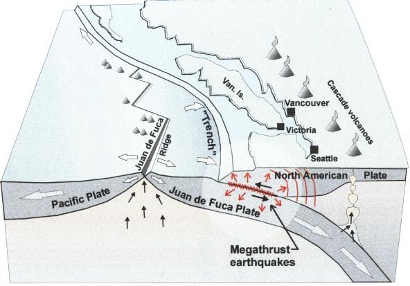
there is minor seismicity between the Denalli and Tintina fault systems. The rate of seismic
activity increases at the eastern edge of the cordillera (see below).

Northern Cordillera

The northern Rocky Mountain region (north of 60N) is one of the most seismically active areas
of Canada. The largest earthquake recorded in this area, to date, is the magnitude 6.9
earthquake of December 23, 1985 in the Mackenzie mountains of the Northwest Territories.
Magnitude 6-plus earthquakes have occurred in the Richardson Mountains of the Yukon
Territory (M=6.2 in May, 1940; M=6.5 in June, 1940, and M=6.6 in March, 1955).

Southern Cordillera

South of 60 N, seismicity in the interior and Rocky Mountain areas drops off rapidly. The largest
earthquake recorded in the southern Cordillera was a magnitude 6.0 in 1918 that struck the
Valemount area of the Rocky Mountain trench. In 1986 a magnitude 5.5 earthquake occurred
near Prince George, causing some minor damage.

Sectional View of the Pacific Offshore

Source: Natural Resources Canada, Earth Sciences Sector, Earthquakes Canada

                                                                                      Page 3 of 12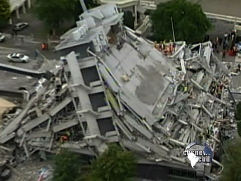
Close up view of the southern half of BC - offshore

Source: Natural Resources Canada, Earth Sciences Sector, Earthquakes Canada

 The populated areas of the province including the Lower Mainland and southern Vancouver
Island have, in recent history, escaped significant earthquakes leading us to be somewhat
complacent about the potential danger from a major event. There is ample evidence that to
suggest that we should be seriously concerned. The following charts, extracted from NRCan’s
website (earthquakescanada.ca) indicate the locations and magnitudes of recent earthquakes
in BC.

                                                                                 Page 4 of 12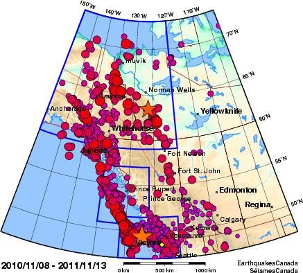
Source: Natural Resources Canada, Earth Sciences Sector, Earthquakes Canada

                                                                              Page 5 of 12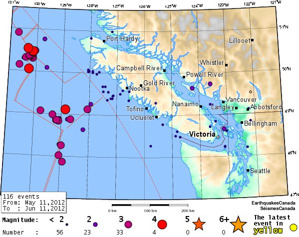
Lower Mainland, Vancouver Island & the Pacific Offshore: Recent Seismicity

Source: Natural Resources Canada, Earth Sciences Sector, Earthquakes Canada

2.      Earthquake Effects on Buildings

It is well known that the west coast of Canada has a high likelihood of earthquakes. The type of
seismic ground motion at a building site depends on a number of factors, including:
         • Distance of the building from the earthquake rupture zone
         • Magnitude of the earthquake
         • Depth of the earthquake rupture, and
         • Soil conditions at the building site

Earthquakes affect buildings differently depending on the type of ground motions and
characteristics of the building structure. Seismic ground motion is typified by both vertical and
horizontal shaking. Generally the horizontal shaking is larger, and causes damage. Large distant
                                                                                     Page 6 of 12
earthquakes contain long-period energy that can impact large (taller) structures, whereas
smaller nearby earthquakes generally contain more high-frequency energy that can damage
smaller (shorter) structures..
If the ground motion is strong enough, it will move a building’s foundation. However, inertia
tends to keep the upper stories in their original position, causing the building to distort. Since
inertial forces are greater when objects are heavier, earthquake forces are greater in heavier
buildings. Higher ground accelerations also create more stress in a structure.
Because buildings shake with different natural frequencies, it is possible for shaking of one
building to be out of phase with its neighbour. If the two buildings are close to each other,
“pounding” of the two buildings into each other may occur, causing damage to both.
Loss of external façade layers of a building is also possible. Failure of secondary structural
masonry and brick items such as chimneys and parapets is also common, especially on older
buildings when the attachment of these materials to the main structure is poor. These falling
items can be a serious hazard.
6.3 quake strikes New Zealand city. February 22, 2011 4:02 PM
Source: cbsnewscom
Page 7 of 123. Performance Criteria for Buildings
Brittle structures such as those constructed of unreinforced brick or poorly reinforced masonry
generally do not perform well under this shaking motion, whereas more ductile structures such
as those constructed of wood, reinforced concrete or structural steel will usually perform much
better. As a result, structural engineers aim to make their building designs as ductile as
possible, using not only ductile materials but paying attention to the ductility of the joints as
well. Research into the ductility of building connections such as at beam-to-column joints is
ongoing and improving steadily.
Buildings designed prior to the 1970’s were not explicitly required to have ductility
incorporated in them. In the early 1980s, the design standards for reinforced concrete were
revised significantly to ensure non-brittle behaviour under design-level earthquake loadings.
More recently structural design has incorporated a “strong column, weak beam” philosophy.
The purpose of this philosophy is to ensure that the building columns will not collapse under
seismic motion while the ductility “demand” is concentrated in the beams, which are better
able to carry load even after their capacity has been exceeded.
The current philosophy of the British Columbia Building Code (2006) provides that most
buildings be designed to a minimum level for life safety. That is, if a “design event” earthquake
were to be experienced the building would not collapse and it would be possible to escape.
That does not mean that the building would not be damaged, in fact major repairs might be
required to rehabilitate it. Some buildings, such as hospitals, fire halls, and schools are assigned
higher safety factors to ensure that they can respond to the design event earthquake with
minimal damage (and so remain operational).
The “design event” earthquake has a 2% probability of exceedance in 50 years (1/2475 year
return period). In other words, there is a 98% probability that a building will not experience this
design event (I suggest trying to stay away from “magnitude” if you can… what the probabilistic
maps provide are ground motions at the 2% in 50 year level… these are then turned into a
“design event” – correct?) in a design life of 50 years. The design ground motions for “firm
ground” conditions (e.g. dense glaciated soils or rock) are specified in the climatic data for each
city and town in the province, based on proximity to known earthquake sites.
Foundation soil conditions can have a significant impact on a building and are taken into
account in the structural design. Sites located on river deltas with a high water table and
underlying deep silt and sand strata (such as some areas in Richmond and Delta) are highly
susceptible to liquefaction (for silts or sands below the water table) and may require special
design treatment from the geotechnical and structural engineer. Ground improvement using a
variety of soil densification techniques is often required to mitigate liquefaction hazard.
Liquefaction caused significant damage in the 2011 Christchurch, New Zealand, earthquake.
The effects of liquefaction are shown in the photos and sketch below.
Page 8 of 12Vehicle buried in Liquefied Soil
Source: dailytelegraph.com.au
Liquefaction immediately following the Tohoku earthquake left this house with a permanent
lean.
Source: japanpropertycentral.com
Page 9 of 12Source: Fact sheets compiled and distributed by the Institution of Professional Engineers of New Zealand
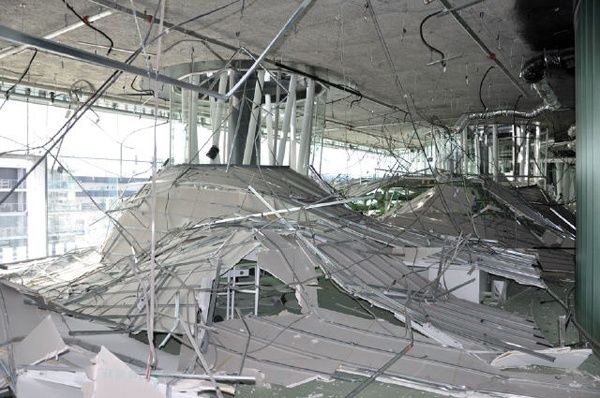
4. Performance of non-structural elements
In buildings of all ages, ceiling systems, and in-ceiling services such as light fittings and air
conditioning supply systems, plumbing and electrical services, book cases and filing cabinets
may suffer significant damage during an earthquake. These are referred to as “non-
structural components”.
Greater effort is being directed to providing suitable seismic restraint for these components
as it has been found that the repair costs can be very large despite the fact that a buildings
performed well structurally. It is not unusual for the building structure to survive an
earthquake relatively intact, but the non-structural components are so badly damaged that
the building is rendered un-usable.
The requirement for lateral restraint of non-structural components is included in the BC
Building Code, but it is an area that is frequently neglected as, to owners, it appears to be
an additional expense with no obvious benefits. Often there is more than one engineer
involved in the design of the seismic restraints for non-structural components. Coordination
between the contactors, the structural engineer of record, and the professionals
Page 10 of 12responsible for the design and implementation of the restraint systems for non-structural
components is vital to minimize the damage to the building in a seismic event.
Non-structural damage: Japan earthquake March 2011
5. What should you do?
a. As a homeowner:
Valuable information on how to prepare your home and family for a major
earthquake can be found at the web-sites below:
http://www.earthquakescanada.nrcan.gc.ca/info-gen/prepare-preparer/eqresist-
eng.php
http://www.seismic.ca.gov/pub/CSSC_2005-01_HOG.pd
http://vancouver.ca/emerg/prepyourself/earthquaketips.htm
b. As a current owner/occupier of an existing building not built to the current
building code:
Building codes are updated on a regular basis and there is currently no requirement
for owners to strengthen their buildings to meet the design event specified for new
buildings (e.g., the current codes). As a result, for buildings that have not been
retrofitted, age is the primary indicator of expected seismic performance. Other
factors, such as the type of construction,
Page 11 of 12structural concept, relative strength of the strong and weak axes of the building,
ground conditions, irregularities in the shape and proximity to adjacent buildings
(pounding effect) all come into play.
Some prudent owners voluntarily undertake strengthening of their buildings. The
Province of BC has undertaken extensive seismic retrofitting of many schools.
If in doubt about the seismic stability of your building, consult with a qualified
structural engineer.
c. As a future developer/owner of a new building:
Potential owners of new buildings should be fully aware that meeting current BC
Building Code minimum requirements does not guarantee that a building will be
serviceable after a design event earthquake. The code simply specifies the level of
structural performance necessary for life safety.
Serviceability is another issue. Only 15-25% of original construction costs are for the
structure, and the prudent owner would be wise to work with his design team to
assess the economic risk associated with loss of use of his new building vs. the cost
of specifying a higher level of performance for both the structure and the non-
structural components.
Acknowledgements:
1. Natural Resources Canada www.earthquakescanada.nrcan.gc.ca
2. IPENZ Engineers New Zealand
3. Woodworks USA
Page 12 of 12You can also read