UCLA UCLA Previously Published Works - eScholarship
←
→
Page content transcription
If your browser does not render page correctly, please read the page content below
UCLA
UCLA Previously Published Works

Title
NGA-Sub ground motion database

Permalink
https://escholarship.org/uc/item/3bn528xc

Authors
Kishida, Tadahiro
Contreras, Victor
Bozorgnia, Yousef
et al.

Publication Date
2021-06-28

Peer reviewed

 eScholarship.org                           Powered by the California Digital Library
                                                            University of California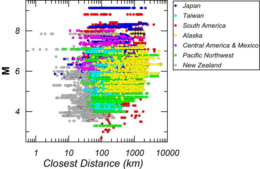
Eleventh U.S. National Conference on Earthquake Engineering
                           Integrating Science, Engineering & Policy
                           June 25-29, 2018
                           Los Angeles, California

         NGA-SUB GROUND MOTION DATABASE
    T. Kishida1, V. Contreras2, Y. Bozorgnia3, N. A. Abrahamson3, S. K. Ahdi2, T. D.
    Ancheta4, D. M. Boore5, K. W. Campbell6, B. Chiou7, R. Darragh8, N. Gregor9, N.
    Kuehn10, D. Y. Kwak11, A. O. Kwok12, P. Lin13, H. Magistrale14, S. Mazzoni10, S.
    Muin15, S. Midorikawa16, H. Si17, W. J. Silva18, J. P. Stewart19, K. E. Wooddell20,
                                     R. R. Youngs21

                                                                    ABSTRACT

This paper summarizes a ground-motion database developed for the NGA-Sub Project. The
database consists of two- and three-component ground-motion recordings from selected
earthquakes in subduction zones. The database also includes the supporting data such as source,
path, and site metadata. The earthquakes are located in Japan, Taiwan, the Pacific Northwest
region of North America, Alaska, Mexico, Central and South America, and New Zealand. The
events in the database are classified as interface, intraslab, or outer-rise, and have magnitudes
ranging from 4 to 9. The database includes more than 71,000 three-component recordings, most
of which are from digital accelerograms. The database includes PGA, PGV, pseudo-spectral
acceleration for eleven damping values between 0.5% and 30%, Fourier amplitude spectra for
frequencies from 0.1 to 100 Hz, and significant-shaking durations based on Arias Intensity.
These data are analyzed in the project to model various ground-motion properties.

1
  Assistant Professor, Dept. of Civil Infrastructure and Environmental Engineering, Khalifa University of Science Technology and Research (KUSTAR), Abu Dhabi,
United Arab Emirates (email: tadahiro.kishida@kustar.ac.ae)
2
  PhD. Student, Dept. Civil Eng., University of California, Los Angeles, CA 90095
3
  Professor, Dept. Civil and Environmental Eng., University of California, Berkeley, CA 94720
4
  Engineer, Risk Management Solutions, Inc., 7575 Gateway Blvd, Newark, CA 94560
5
  Emeritus Scientist, United States Geological Survey, Menlo Park, CA 94025
6
  Principal, Science & Analytics, CoreLogic, Inc., Oakland, CA 94607
7
  Seismologist, California Department of Transportation, Sacramento, CA 95811
8
  Seismologist, Pacific Engineering and Analysis, El Cerrito, CA 94530
9
  Seismologist, Bechtel Corporation, San Francisco, CA 94105
10
   Project Scientist, Dept. Civil and Environmental Eng., University of California, Berkeley, CA 94720
11
   Geotechnical Modeler, Risk Management Solutions, Inc., 7575 Gateway Blvd, Newark, CA 94560
12
   Assistant Professor, National Taiwan University, Taiwan
13
   Seismologist, Sinotech Engineering Consultants, Inc., Taiwan
14
   Principal Research Scientist, FM Global, Research Division, Norwood, MA 02062
15
   PhD. Student, Dept. Civil and Environmental Eng., University of California, Berkeley, CA 94720
16
   Professor, Tokyo Institute Technology, Japan
17
   Researcher, Tokyo Institute Technology, Japan
18
   Senior Seismologist, Pacific Engineering and Analysis, El Cerrito, CA 94530
19
   Professor and Chair, Dept. Civil Eng., University of California, Los Angeles, CA 90095
20
   PhD. Student, Dept. Earth and Planetary Science, University of California, Berkeley, CA 94720
21
   Principal Engineer, Wood plc, Oakland CA 94612

T. Kishida, V. Contreras, Y. Bozorgnia, Y. Bozorgnia, N. A. Abrahamson, S. K. Ahdi, T. D. Ancheta, D. M. Boore, K. W. Campbell, B. Chiou,
R. Darragh, N. Gregor, N. Kuehn, D. Y. Kwak, A. O. Kwok, P. Lin, H. Magistrale, S. Mazzoni, S. Muin, S. Midorikawa, H. Si, W. J. Silva, J. P.
Stewart, K. E. Wooddell, R. R. Youngs, NGA-Sub Ground Motion Database. Proceedings of the 11th National Conference in Earthquake
Engineering, Earthquake Engineering Research Institute, Los Angeles, CA. 2018.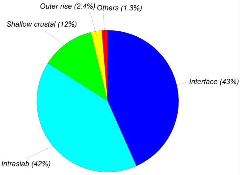
Eleventh U.S. National Conference on Earthquake Engineering
                        Integrating Science, Engineering & Policy
                        June 25-29, 2018
                        Los Angeles, California

                                    NGA-Sub Ground Motion Database

T. Kishida1, V. Contreras2, Y. Bozorgnia3, N. A. Abrahamson3, S. K. Ahdi2, T. D. Ancheta4, D.
M. Boore5, K. W. Campbell6, B. Chiou7, R. Darragh8, N. Gregor9, N. Kuehn10, D. Y. Kwak11, A.
O. Kwok12, P. Lin13, H. Magistrale14, S. Mazzoni10, S. Muin15, S. Midorikawa16, H. Si17, W. J.
Silva18, J. P. Stewart19, K. E. Wooddell20, R. R. Youngs21

                                                             ABSTRACT

           This paper summarizes a ground-motion database developed for the NGA-Sub Project. The
           database consists of two- and three-component ground-motion recordings from selected
           earthquakes in subduction zones. The database also includes the supporting data such as
           source, path, and site metadata. The earthquakes are located in Japan, Taiwan, the Pacific
           Northwest region of North America, Alaska, Mexico, Central and South America, and New
           Zealand. The events in the database are classified as interface, intraslab, or outer-rise, and
           have magnitudes ranging from 4 to 9. The database includes more than 71,000 three-
           component recordings, most of which are from digital accelerograms. The database includes
           PGA, PGV, pseudo-spectral acceleration for eleven damping values between 0.5% and 30%,
           Fourier amplitude spectra for frequencies from 0.1 to 100 Hz, and significant-shaking
           durations based on Arias Intensity. These data are analyzed in the project to model various
           ground-motion properties.

1
  Assistant Professor, Dept. of Civil Infrastructure and Environmental Engineering, Khalifa University of Science Technology and Research
(KUSTAR), Abu Dhabi, United Arab Emirates (email: tadahiro.kishida@kustar.ac.ae)
2
  PhD. Student, Dept. Civil Eng., University of California, Los Angeles, CA 90095
3
  Professor, Dept. Civil and Environmental Eng., University of California, Berkeley, CA 94720
4
  Engineer, Risk Management Solutions, Inc., 7575 Gateway Blvd, Newark, CA 94560
5
  Emeritus Scientist, United States Geological Survey, Menlo Park, CA 94025
6
  Principal, Science & Analytics, CoreLogic, Inc., Oakland, CA 94607
7
  Seismologist, California Department of Transportation, Sacramento, CA 95811
8
  Seismologist, Pacific Engineering and Analysis, El Cerrito, CA 94530
9
  Seismologist, Bechtel Corporation, San Francisco, CA 94105
10
   Project Scientist, Dept. Civil and Environmental Eng., University of California, Berkeley, CA 94720
11
   Geotechnical Modeler, Risk Management Solutions, Inc., 7575 Gateway Blvd, Newark, CA 94560
12
   Assistant Professor, National Taiwan University, Taiwan
13
   Seismologist, Sinotech Engineering Consultants, Inc., Taiwan
14
   Principal Research Scientist, FM Global, Research Division, Norwood, MA 02062
15
   PhD. Student, Dept. Civil and Environmental Eng., University of California, Berkeley, CA 94720
16
   Professor, Tokyo Institute Technology, Japan
17
   Researcher, Tokyo Institute Technology, Japan
18
   Senior Seismologist, Pacific Engineering and Analysis, El Cerrito, CA 94530
19
   Professor and Chair, Dept. Civil Eng., University of California, Los Angeles, CA 90095
20
   PhD. Student, Dept. Earth and Planetary Science, University of California, Berkeley, CA 94720
21
   Principal Engineer, Wood plc, Oakland CA 94612

T. Kishida, V. Contreras, Y. Bozorgnia, Y. Bozorgnia, N. A. Abrahamson, S. K. Ahdi, T. D. Ancheta, D. M. Boore,
K. W. Campbell, B. Chiou, R. Darragh, N. Gregor, N. Kuehn, D. Y. Kwak, A. O. Kwok, P. Lin, H. Magistrale, S.
Mazzoni, S. Muin, S. Midorikawa, H. Si, W. J. Silva, J. P. Stewart, K. E. Wooddell, R. R. Youngs, NGA-Sub
Ground Motion Database. Proceedings of the 11th National Conference in Earthquake Engineering, Earthquake
Engineering Research Institute, Los Angeles, CA. 2018.
Introduction
Uniformly-processed ground-motion data are essential for ground-motion studies. Next
Generation Attenuation (NGA) ground-motion databases (e.g., http://ngawest2.berkeley.edu/,
http://peer.berkeley.edu/ngaeast/) produced by the Pacific Earthquake Engineering Research
Center (PEER) provide these data sets, which include time series and spectral data with
associated metadata for selected earthquakes recorded in different tectonic settings and regions.
Currently, the research program NGA-Sub is being conducted by PEER to develop data
resources and ground-motion models (GMMs) for subduction-zone earthquakes [1]. The
program is based on technical interactions among many individuals and organizations around the
world. The database contains ~1,880 events from Japan, Taiwan, the Pacific Northwest region of
North America, the state of Alaska in the United States, South America, Central America,
Mexico, and New Zealand. More than 71,000 three-component time series are included from
different data providers. The unprocessed waveforms were processed using a uniform set of
instrument-correction, frequency filtering, and baseline-correction algorithms developed by
PEER to obtain corrected acceleration time series, pseudo-spectral acceleration (PSA), Fourier
amplitude spectra (FAS) and significant-shaking durations based on Arias Intensity (AI). These
data are used to generate multiple new GMMs, which will significantly improve current models
that rely on more limited data sets that encompass mainly moderate-magnitude events. This
study describes the database including the supporting source, path, and site metadata.
Selected Earthquakes
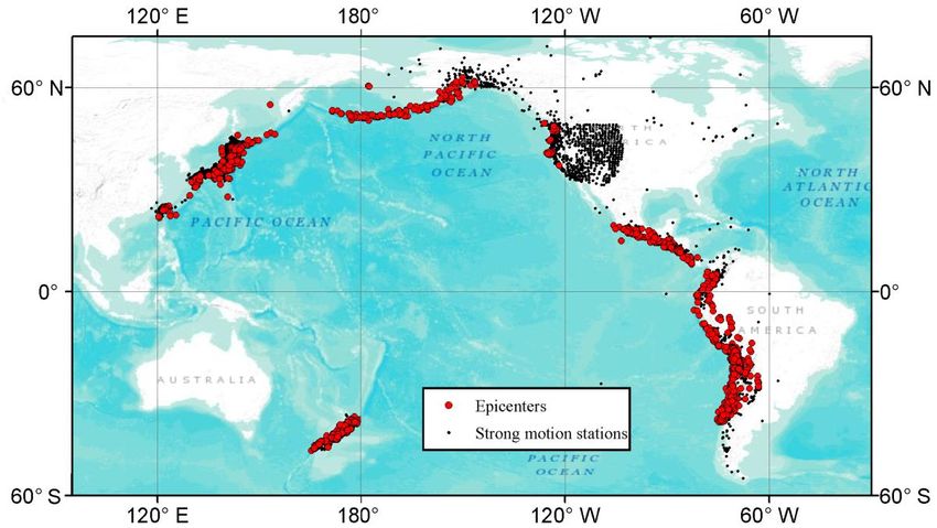
Figure 1 plots the epicenter and station locations of all records in the NGA-Sub database. In the
development of the database, we mainly collected and processed data from events having
magnitudes greater than 5.0 by reviewing available catalogs such as the International
Seismological Centre (ISC) website (http://www.isc.ac.uk/iscbulletin/search/catalogue/). Some
relevant events with magnitudes less than 5.0 were also included for specific regions such as
Chile based on data availability and quality. We collected and processed recordings mostly from
digital instruments, but some important older analog records are also included. The time period
covered by the database is from the late 1930s to the present, including recent significant
earthquakes from 2016. More than 85% of the time series in the database were recorded after
2000. Figure 2 shows the distribution of the current database by region. The total number of
three-component recordings, events, and stations are approximately 71,000, 1,900, and 6,100,
respectively. Figure 2(a) shows that Japan and Taiwan provide the largest number of time series.
Figure 2(b) shows that South America is the region with the largest number of subduction events.
Figure 2(c) shows that Japan and the U.S. Pacific Northwest have the largest number of
recording stations in the current dataset.Figure 1. Epicentral and recording station locations in NGA-Sub database
Figure 2. Regional distribution of the NGA-Sub database, (a) number of recordings, (b) number
of events, (c) number of stations.
Database and Flatfile Overview
The NGA-Sub database consists of multiple component databases: a ground-motion database, an
earthquake source database, and a site database. A “flatfile”, which is a single summary data file
used to develop GMMs, is generated by combining selected data from these component
databases. This section provides an overview of these databases.
Ground Motion Database
More than 71,000 records have been processed and filtered following the standard PEER data-
processing methods [2, 3] to provide uniformly-processed time series, PGA, PGV, PSA, FAS,and duration metrics in the ground-motion database. Instrument corrections were applied to the
recorded time series in the frequency domain, as necessary. A time window for data processing
was selected following the recommendations of previous studies [4, 5]. A 2% taper was applied
to the start and end of the time window. An acausal Butterworth bandpass filter was applied after
reviewing the FAS shape and the signal-to-noise ratio between the S-wave (or the entire time
series) and the pre-event noise window (when available) on a component-by-component basis
(e.g. [6]). PSA for 5% and other oscillator damping ratios, as well as FAS, were calculated at
selected frequencies for all processed time histories following [3, 4]. The metadata from all the
processing steps are also stored in the database including record starting time, location of station,
time-window locations, and applied high-pass and low-pass filter corner frequencies. The
processed data were also reviewed by visual inspection (e.g. late-P and -S triggered flag) and
through residual analyses (e.g. PSA and FAS quality flags) as described in [3]. The largest
distance is approximately 2,000 km to capture the attenuation of large-magnitude subduction
events, which is useful in some regions. However, the largest distances depend on the region due
to regional attenuation rates and station distributions. Figure 3 shows a scatter plot of recordings
between magnitude and closest distance. Data distributions show that M and closest distance is
positively correlated for all regions and that Japan, South America, Central America and Mexico
are the only regions that include the events with M > 8.0.
Approximately 90% of the recordings are from accelerometers, while the remainder are
from broadband seismometers. Table 1 shows the agencies that provided the time series used in
the development of the database. For New Zealand recordings, we reviewed the processed time
series published in [7], then directly adopted these records because selected high-pass and low-
pass corner frequencies are consistent between [7] and the PEER data processing method. The
agency names and acronyms are given in full in the acknowledgements section.
Table 1. Data resources of time series
Region Agencies Providing Data
Japan K-NET, KiK-net, PARI, JMA, NOAA, Hi-net
Taiwan CWB, IES, K-NET
Pacific Northwest CESMD, COSMOS, IRIS, NSMP, NCEDC, GSC
Alaska CESMD, COSMOS, IRIS, GSC
CESMD, COSMOS, NOAA, IRIS, GFZ, RENADIC, CSN, CISMID,
South America
NORSAR, RNAC
Central America and Mexico NORSAR, CESMD, COSMOS, NOAA, IRIS, UNAM, MARN
New Zealand GeoNetFigure 3. Scatter plot of closest distance versus magnitude
Earthquake Source Database
The earthquake source database consists of the event catalog and source parameters such as
origin time, seismic moment (M0), moment magnitude (M), hypocentral location and finite-fault
attributes. The event catalog is developed by reviewing published catalogs (e.g. ISC catalog) and
past studies (e.g. [8, 9, 10, 11]) with the inclusion of recent events. Regional studies and reports
on subduction earthquakes were also reviewed along with interaction between multiple
international experts to identify the earthquakes included in the dataset. Source parameters such
as M and hypocentral locations are selected from several global and local data resources (e.g.
[12, 13, 14]). The Global Centroid-Moment-Tensor catalog (GCMT) is given priority to
determine M. Its standard deviations are also calculated when multiple moment-tensor solutions
are available including special studies and source-inversion analyses. However, when M is not
available, usually for smaller-magnitude earthquakes, the optimal estimate of M is determined
from values of local magnitude (ML), surface-wave magnitude (MS), and body-wave magnitude
(mb) using correlations based on regional data.
Earthquakes have also been classified as either: interface, intraslab, outer-rise, or shallow
crustal events by reviewing past studies and comparing hypocentral locations to available slab
models for each region [15]. The mechanism of the events is defined using event rake angles,
when available, aiming to be consistent with the earthquake classification. Figure 4 shows the
event classification distribution in the database and indicates that interface and intraslab events
are nearly evenly distributed. As a part of the earthquake source database, finite-fault models
have been collected by reviewing past studies and several data resources (e.g. [13, 16, 17, 18]).
More than 80 events have finite-fault models documented in the database, which covers about
35% of all records. Details of the methods to interpret and use these finite-fault models are
described in [19]. Event classes (i.e. foreshock and aftershock flags) are also provided based on
previous studies and the method described in [20].Figure 4. Distribution of event classification in the earthquake source database
Site Database
Approximately 6,100 stations are included in this database. The site database includes high-level
metadata for each station, such as station name, station ID, recording network, geodetic
coordinates, instrument location, and sensor depth. Information describing the soil profile
characteristics of the site, such as the time-averaged shear-wave velocity (VS) in the upper 30 m
(VS30) and depth to VS horizons (Zxx) to model basin effects are also included. The value of VS30 is
either (1) computed from measured VS profiles collected from the open literature where such
information is available (44% of all sites), of which 59% were measured to a maximum profile
depth of 30 m or deeper; or (2) assigned using various proxies (56% of all sites) developed for
different geographic regions and using different secondary information, including surface
geology, topographic slope, elevation, and geomorphic terrain classification. Details of these
proxies can be found in Table 1 of [21]. Zxx is assigned from measured VS profiles if available, or
from 3D crustal velocity models available in the Cascadia subduction region and Japan (see
details in [21]).
Flatfile
The flatfile is the summary table used to develop the GMMs. It includes key metadata and
ground-motion parameters extracted from the aforementioned databases. Ground-motion
parameters include PGA, PGV, PSA and FAS at selected frequencies and AI and significant-
shaking durations between selected percentages of AI. PSA based on different definitions (i.e.
as-recorded and RotDnn) are provided as described in [22]. The current approach is similar to
past NGA databases [2, 3, 4] that are available through the PEER website [23].
Path-dependent parameters that are unique to each record are also included in the flatfile.
Such parameters are epicentral distance, hypocentral distance, Joyner-Boore distance, and closest
distance to the rupture surface. Because subduction earthquakes can be deeper than crustal
earthquakes, and the database includes many large-magnitude events, the difference between
these distance metrics can be significant.Summary
The PEER NGA-Sub database includes a ground-motion database that compiles engineering
seismological resources for different geographic regions around the world. The database
combines parameters from different databases: the ground-motion database, earthquake-source
database and site database. Moderate-to-large magnitude earthquakes are included for which
time series were recorded by strong-motion or broadband seismograph stations. Time series were
obtained from various agencies and were uniformly processed through the standard PEER data
processing methodology [2, 3]. A variety of metadata are available to users, including uniformly
processed time series, PGA, PGV, PSA, FAS, site condition and distance metrics. The developed
ground-motion data are useful for GMM development for subduction-zone earthquakes.
Acknowledgments
The NGA-Sub research project was supported by FM Global, USGS, California Department of
Transportation, and Pacific Gas & Electric Company. The support of these organizations is
gratefully acknowledged. Any opinions, findings, and conclusions or recommendations
expressed in this material are those of the authors and do not necessarily reflect those of the
sponsoring agencies. The data distribution services provided by Centro Sismologico Nacional in
University of Chile (CSN), Incorporated Research Institutions for Seismology (IRIS), Institute of
Earth Sciences, Academia Sinica in Taiwan (IES), International Seismological Centre (ISC),
Japan Meteorological Agency (JMA), National Research Institute for Earth Science and Disaster
Prevention in Japan (NIED), Northern California Earthquake Data Center (NCEDC), and USGS
were used to review event-related metadata, and to derive parameters included in the NGA-Sub
database. The Center for Engineering Strong Motion Data (CESMD), Centro Peruano Japonés de
Investigaciones Sísmicas y Mitigación de Desastres in Peru (CISMID), Centro Sismologico
Nacional in University of Chile (CSN), Geological Survey of Canada (GSC), Red de Cobertura
Nacional de Acelerografos in University of Chile (RENADIC), Helmholtz-Zentrum Potsdam
Deutsches GeoForschungsZentrum (GFZ), Institute of Earth Sciences, Academia Sinica in
Taiwan (IES), Japan Meteorological Agency (JMA), Laboratorio de Ingeniería Sísmica in
University of Costa Rica (LS), National Centers for Environmental Information (NOAA),
National Research Institute for Earth Science and Disaster Prevention in Japan (NIED),
NORSAR, Northern California Earthquake Data Center (NCEDC), Port and Airport Research
Institute in Japan (PARI), Red Nacional de Acelerografos de Colombia (RNAC), The Central
Weather Bureau in Taiwan (CWB), Consortium of Organizations for Strong-Motion Observation
Systems (COSMOS), USGS National Strong-Motion Project (NSMP), Ministerio de Medio
Ambiente y Recursos Naturales (MARN) in El Salvador, Red Acelerográfica del IINGEN de la
UNAM (UNAM) in Mexico, GeoNet in New Zealand provided waveform data. BCHydro also
provided data for the subduction database. The authors thank these organizations.
References
1. Bozorgnia, Y., Kishida, T., Abrahamson, N. A., Ahdi, S. K., Ancheta, T. D., Archuleta, R. J., Atkinson, G.,
Boore, D. M., Campbell, K. W., Chiou, B., Contreras, V., Darragh, R., Gregor, N., Idriss, I.M., Ji, C., Kamai,
R., Kuehn, N., Kwak, D. Y., Kwok, A., Lin, P.S., Magistrale, H., Mazzoni, S., Muin, S., Midorikawa, S.,Parker, G., Si, H., Silva, W. J., Stewart, J. P., Walling, M., Wooddell, K. E., and Youngs, R. R. (2018). NGA-
Sub research program, Proc., 11th U.S. National Conference on Earthquake Engineering, June 25-29, 2018,
Los Angeles, California, Paper No. 1705.
2. Chiou, B., Darragh, R., Gregor, N., and Silva, W. (2008). NGA project strong-motion database, Earthquake
Spectra, Vol. 24, No. 1, pp. 23–44.
3. Ancheta, T. D., Darragh, R. B., Stewart, J. P., Seyhan, E., Silva, W. J., J. Chiou, B. S., Wooddell, K. E., Graves,
R. W., Kottke, A. R. Boore, D. M., Kishida, T., and Donahue, J. L. (2014). "NGA-West 2 Database".
Earthquake Spectra, EERI, August 2014, Vol. 30, No. 3, pp. 989-1005.
4. Goulet, C.A., Kishida, T., Cramer, C.H., Darragh, R.B., Silva, W.J., Hashash, Y.M.A., Harmon, J., Stewart,
J.P., Wooddell, K.E., and Youngs, R.R. (2014). PEER NGA-East Database, Pacific Earthquake Engineering
Research Center, University of California, Berkeley, CA, PEER Report 2014/09.
5. Kishida, T., Kayen, R.E., Ktenidou, O.-J., Silva, W.J., Darragh, R.B. and Watson-Lamprey, J. (2014). PEER
Arizona Strong-Motion Database and GMPEs Evaluation, Pacific Earthquake Engineering Research Center,
University of California, Berkeley, CA, PEER Report 2014/09.
6. Boore, D.M., and Akkar S. (2003). Effect of causal and acausal filters on elastic and inelastic response spectra,
Earthquake Engineering and Structural Dynamics, Vol. 32, pp. 1729–1748.
7. Van Houtte, C., Bannister, S., Holden, C., Bourguignon, S. and McVerry, G. (2016). The New Zealand strong
motion database, Bulletin of the New Zealand Society for Earthquake Engineering, Vol. 50, No. 1, March 2017.
8. Crouse, C. (1991). Ground-motion attenuation equations for Cascadia subduction zone earthquakes, Earthquake
Spectra, Vol. 7, pp. 201–236.
9. Youngs, R., Chiou, S., Silva, W., and Humphrey, J. (1997). Strong ground motion attenuation relationships for
subduction zone earthquakes, Seismological Research Letters, Vol. 68, pp. 58–73.
10. Atkinson, G.M., and Boore, D.M. (2003). Empirical ground-motion relations for subduction-zone earthquakes
and their application to Cascadia and other regions, Bulletin of the Seismological Society of America, Vol. 93,
No. 4, pp. 1703–1729.
11. Abrahamson, N., Gregor, N., and Addo, K. (2016), BC Hydro ground motion prediction equations for
subduction earthquakes, Earthquake Spectra, Vol. 32, No. 1, pp. 23–44.
12. International Seismological Centre (2013). On-line Bulletin, http://www.isc.ac.uk, Internatl. Seis. Cent.,
Thatcham, United Kingdom.
13. United States Geological Survey. Search Earthquake Archives, http://earthquake.usgs.gov/earthquakes/search/,
(Last accessed, May 2016)
14. Incorporated Research Institutions for Seismology. https://www.iris.edu/hq/ (Last accessed, May 2016).
15. Hayes, G.P., Wald, D.J., and Johnson. R.L. (2012). Slab1.0: A three-dimensional model of global subduction
zone geometries, Journal of. Geophysical Research, Vol. 117, No. B01302, doi:10.1029/2011JB008524.
16. Association for the Development of Earthquake Prediction, Japan (1999). A catalog of inhomogeneous fault
parameters in Japan (in Japanese).
17. Mai, M., and Thingbaijam, K.K.S. (2014). SRCMOD: An online database of finite-fault rupture models,
Seismological Research Letters, Vol. 85, No. 6, pp.1348–1358.
18. Ye, L., Lay, T., Kanamori, H., and Rivera, L. (2016), Rupture characteristics of major and great (Mw ≥ 7)
megathrust earthquakes from 1990-2015: 1. Moment scaling relationships, Journal of Geophysical Research,
Vol. 121, pp. 821–844.
19. Contreras, V., Stewart, J.P., Darragh, R B., Kishida, T., and Youngs, R.R. (2017). Earthquake source
parameters for chilean events for use in NGA-Subduction project, Proc., 11th U.S. National Conference on
Earthquake Engineering, June 25-29, 2018, Los Angeles, California, Paper No. 1783.
20. Wooddell, K.E., and Abrahamson, N.A. (2014), Classification of main shocks and aftershocks in the NGA-
West2 database, Earthquake Spectra, Vol. 30, No. 3, pp. 1257–1267.21. Ahdi, S.K., Ancheta T.D., Contreras, V., Kishida, T., Kwak, D.Y., Kwok, A.O., Parker, G.A., Bozorgnia, Y.,
Stewart, J.P. (2017). NGA-Subduction site database, Proc., 16th World Conference on Earthquake Engineering,
Santiago, Chile, January 9–13, 2017, Paper No 4926.
22. Boore, D.M. (2010). Orientation-independent, nongeometric-mean measures of seismic intensity from two
horizontal components of motion, Bulletin of the Seismological Society of America, Vol. 100, pp. 1830–1835.
23. Pacific Earthquake Engineering Research Center (2016). http://peer.berkeley.edu/ (Last accessed on May 2016).You can also read