Ice surface changes in Eisriesenwelt (Salzburg, Austria) based on LIDAR measurements between 2017 and 2020 - The ...
←
→
Page content transcription
If your browser does not render page correctly, please read the page content below
Ice surface changes in Eisriesenwelt
(Salzburg, Austria) based on LIDAR
measurements between 2017 and 2020

ABSTRACT                                         ZUSAMMENFASSUNG
Based on highly accurate laser detection         Veränderungen der Eisoberfläche in
and ranging (LIDAR) surveys in the show          der Eisriesenwelt (Salzburg, Öster-
cave part of Eisriesenwelt in 2017, 2019         reich) anhand von LIDAR Messungen
and 2020, areal and mass-related compar-         zwischen 2017 und 2002
isons of the ice cover were carried out. The     Basierend auf hochexakten Vermessungen         Manfred F. Buchroithner
results show that within this three-year         des Schauhöhlenteils der Eisriesenwelt mit-    Institute of Cartography, TU Dresden,
period the total ice surface of about            tels Laser-Scanner in den Jahren 2017, 2019    01069 Dresden, Germany
11,100 m2 remained nearly constant and a         und 2020 wurden flächenhafte und mas-          Manfred.Buchroithner@tu-dresden.de
slight increase in ice volume occurred. De-      senbezogene Vergleiche der Eisbedeckung
tailed three-dimensional visualisations of the   angestellt. Es zeigte sich, dass über diesen   Thomas Gaisecker
dynamics of the ice surface within the study     Zeitraum von drei Jahren die Gesamteisflä-     RIEGL Laser Measurement Systems GmbH,
period are shown and discussed.                  che von etwa 11.100 m2 nahezu gleich           3580 Horn
                                                 blieb, und ein geringer Eisvolumenzuwachs      tgaisecker@riegl.com
                                                 zu verzeichnen war. Detaillierte dreidimen-
                                                 sionale Visualisierungen zur Dynamik der       Eingelangt: 5.7.2020
                                                 Eisoberfläche werden für den Untersu-          Angenommen: 16.7.2020
                                                 chungszeitraum gezeigt und diskutiert.

INTRODUCTION
Eisriesenwelt, located approximately 50 km south of               2017, 2019 and 2020, in order to obtain detailed spatial
the City of Salzburg at an elevation of 1640 m, is one            data for a better understanding of the relationship
of the largest ice caves on Earth.                                between climate and ice dynamics. For information
In order to monitor the ice masses in times of global             about the ice cave and the three-dimensional
warming, a series of three-dimensional ice-surface                mapping by means of terrestrial laser-scanning the
mapping campaigns have been carried out since 2010.               reader is referred to Buchroithner et al. (2011), Milius
After an initial interval of three years (2010, 2013,             & Petters (2012), Petters (2012), and Buchroithner
2016), the most recent campaigns were performed in                (2015).

DATA ACQUISITION
The data presented in this paper were acquired in                 scanned with a spatial sampling resolution of 9 mm at
2017, 2019 and 2020 always at the end of April using              10 mdistance (equalling 0.05° resolution in azimuth
a RIEGL VZ-400i LIDAR instrument mounted on a                     and elevation). The acquisition of the LIDAR data of a
tripod (Fig. 1), taken from approximately 350 scan                full 360° scan takes 30 seconds. Every 10 m such a full
positions during each measurement campaign. With a                360° scan was taken on the visitor walkway. Each scan
diameter of 206 mm and a height of 308 mm the scan-               contains approximately 15 million measurements,
ner, which weighs 9.7 kg, uses a laser source in the near         which result in a point cloud of around 5 billion
infrared (wavelength of 1550 nm), which means that                measurements for each campaign.
the laser light is invisible and eye save. Data acquisiti-        Automatic on-board registration aligned each newly
on can be done in absolute darkness. Each data set was            acquired scan position with respect to all previously

62                                                                                       Die Höhle / 71. Jg. / Heft 1–4/2020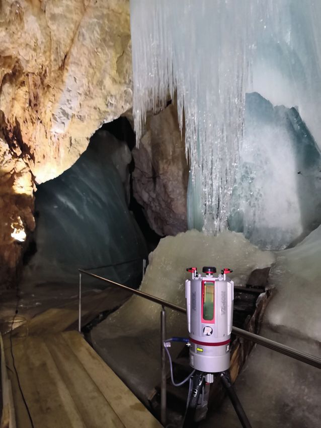
Buchroithner, Gaisecker / Ice surface changes in Eisriesenwelt based on LIDAR measurements between 2017 and 2020

                                                                                     Fig. 1: The RIEGL VZ-400i
                                                                                     terrestrial laser-scanner mounted
                                                                                     on a tripod on the visitor walkway
                                                                                     of the Eisriesenwelt.
                                                                                     Abb. 1: Der RIEGL VZ-400i
                                                                                     terrestrische Laserscanner,
                                                                                     montiert auf einem Dreibein,
                                                                                     platziert auf dem Besucherweg
                                                                                     der Eisriesenwelt.
                                                                                                  Foto: Thomas Gaisecker

acquired data. Thus, the registration did not require       of each measurement campaign, i.e. after approxima-
any user interaction as long as the data of the newly ac-   tely 15 h inside the cave, all data were already registered
quired scan position overlapped sufficiently. At the end    within the correct coordinate system (Figs. 2, 3).

DATA PROCESSING AND VISUALISATION
After transferring the data to RIEGL’s postprocessing-      After completion of the data registration the whole
software RiSCAN PRO a comprehensive report on the           point cloud was divided into small cubes, the afore-
project was automatically generated. Additionally,          mentioned voxels. For the Eisriesenwelt dataset we
RiSCAN PRO provides easy-to-use tools for rapid and         used a voxel size of 10 cm. Within each voxel the dis-
expressive visual inspection of data accuracy (Fig. 4)      tribution of the scan data was analysed and a best fit
which allowed to verify at a single glance that the data    plane was calculated. The standard deviation repre-
of all scan positions are consistent within a few milli-    sents the noise of the data with respect to this plane.
metres. The data in Fig. 4 show a voxel dataset colou-      An interpretation of this standard deviation only ma-
rised by the standard deviation attribute of each voxel.    kes sense on voxels representing almost flat areas. In
In three-dimensional computer graphics, a voxel re-         the case of poor registration (i.e. if the scan data do not
presents a value on a regular grid in three-dimensional     fit together) the standard deviation would increase si-
space, e.g. a cube.                                         gnificantly. Nevertheless this voxel dataset is just used

Die Höhle / 71. Jg. / Heft 1–4/2020                                                                                 63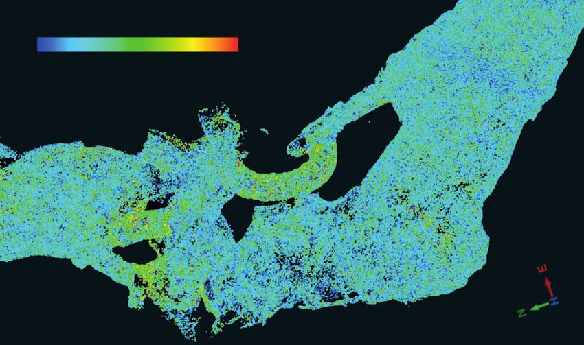
Buchroithner, Gaisecker / Ice surface changes in Eisriesenwelt based on LIDAR measurements between 2017 and 2020

                                                                                   Mörkdom

                                                                                                                   Eispalast

                                                                                                             Sturmsee,
                                                                     Odinsaal                                Mörkgletscher
                                                                                                             Eistor

                                                           Niflheim,
                                                           Donardom

                                                        Hymirburg

                                                  Großer Eiswall

                                         Posselthalle

  0                  100 m

Fig. 2: Plan view and profile view of the registered scan data of the ice-bearing portion of the Eisriesenwelt colourised according
to reflectance. The ice is coloured from white to blue, blue indicates the lowest reflectance values. Rock is displayed in grey.
Abb. 2: Plan- und Profilansicht der aufgenommenen Scan-Daten des eisführenden Teils der Eisriesenwelt ihren Reflexionswerten
entsprechend eingefärbt. Eis wird in weißen bis blauen Farben gezeigt, wobei Blau die niedrigsten Reflexionswerte anzeigt. Fels
ist grau.

  0                          100 m

Fig. 3: Enlargement of the plan view of the show cave part of Eisriesenwelt from Fig. 2.
Abb. 3: Vergrößerung der Planansicht des Schauteils der Eisriesenwelt von Abb. 2.

64                                                                                         Die Höhle / 71. Jg. / Heft 1–4/2020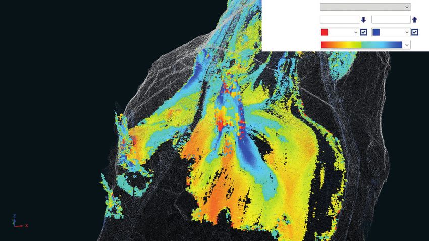
Buchroithner, Gaisecker / Ice surface changes in Eisriesenwelt based on LIDAR measurements between 2017 and 2020

       0 mm                 5 mm               10 mm

Fig. 4: Registration accuracy of LIDAR data in the region Hymirburg and Großer Eiswall (data from April 2017).
Abb. 4: Registrierungsgenauigkeit der LIDAR-Daten im Bereich Hymirburg und Großer Eiswall (Datenaufnahmen April 2017).

for a visual inspection of the three-dimensional data-        three-dimensional dataset of Eisriesenwelt (compared
set. Duringregistration plane patches were extracted          to the previous ones, cf. Buchroithner, 2015). The focus
from the scan data of each scan position. The software        on the following campaigns (2019, 2020) was to ana-
identifies common plane patches from different scan           lyse changes of the ice bodies. RIEGL’s postprocessing-
positions, links them together and minimises the er-          software offers a powerful tool called “voxel compari-
rors between all these linked plane patches by using          son”. This tool allows a real three-dimensional surface
an iterative matching algorithm. Figure 5 shows a             comparison. In a first step we automatically extracted
small excerpt of the statistical registration report. By      voxels of equal size from the reference dataset (2017).
analysing the full statistical report one can easily iden-    For this we used a voxel size of 25 cm. The scan data
tify if a scan position is registered sufficiently against    within each voxel were analysed and subsequently a
the adjacent ones. In the present study this was very         principle component analysis delivered an estimated
well the case.                                                plane with a normal vector for every voxel.
Once the registration was finished the whole point            The distinction between ice surface and rock surface
cloud of more than 5 billion points was resampled to          is based on the intensity of the recorded reflectance
an equalised point distance of 2 cm. This reduced the         signal and was automatically carried out by the soft-
amount of data dramatically, while all details were still     ware.
available (and hence visible). Due to the many scan           For the ice-covered area, which extends for a distance
positions and the massive overlap of all scan data from       of about 500 m behind the entrance of the cave, an
the different positions the resulting final point cloud       area of approximately 8.300 m² was calculated
with 2 cm-resolution showed practically no (close to          (whereby distance refers to a vertical nadir projection).
zero) scan shadows or missing areas (except of very           Above this (basal) area there exists a total of approxi-
few percent of the total) and can be considered highly        mately 161.000 voxels resulting in about 11.100 m² of
consistent (Fig. 6).                                          total ice surface. Based on experience with other sur-
Finally, the datasets from the different campaigns were       face calculations based on LIDAR data using the same
re-aligned against each other within official Austrian        approach, we assume that the latter value represents
Geodetic Reporting System (BMN) with a high degree            the correct size of the actual ice surface in 2020.
of accuracy. The purpose of the measurement cam-              The significant difference of this ice-surface value
paign 2017 was to generate a new highly accurate              compared to estimates obtained during previous

Die Höhle / 71. Jg. / Heft 1–4/2020                                                                                      65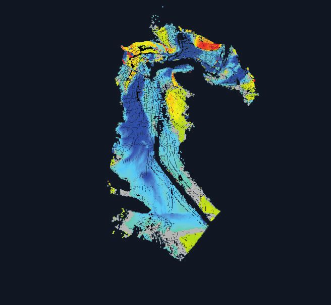
Buchroithner, Gaisecker / Ice surface changes in Eisriesenwelt based on LIDAR measurements between 2017 and 2020

                                   0.004
     Residuals in distance [m]

                                   0.003

                                                                                         Fig. 5: A small excerpt of the
                                   0.002
                                                                                         statistical registration report.
                                                                                         Upper diagram: Standard
                                                                                         deviation and standard deviation
                                   0.001
                                                                                         MAD (mean absolute deviation;
                                                                                         this type of the standard deviation
                                   0.000                                                 is robust against outliers) of plane
                                                                                         matches for each scan position.
                                                                                         Lower diagram: Standard
                                                                                         deviation of plane matches with
                                                                                         50% quantile (boxes) and 95%
                                 0.0100                                                  quantile (whiskers) for each scan
                                                                                         position.
                                 0.0075
                                                                                         Abb. 5: Ein kleiner Auszug des
     Residuals in distance [m]

                                 0.0050                                                  statistischen Registrierungsbe-
                                                                                         richts. Oberes Diagramm:
                                 0.0025                                                  Standardabweichung und
                                                                                         Standardabweichung-MAD (mean
                                 0.0000                                                  absolute deviation; dieser Typ der
                                                                                         Standardabweichung ist robust
                                 –0.0025                                                 hinsichtlich Ausreißern) für die
                                                                                         Oberflächen-„Passung“ jeder
                                 –0.0050                                                 Scan-Position. Unteres Diagramm:
                                                                                         Standardabweichung der
                                 –0.0075                                                 Oberflächen-„Passung“ mit 50%-
                                                                                         Quantilen („boxes“) und 95%-
                                 –0.0100                                                 Quantilen („whiskers“) für jede
                                           ScanPos_26
                                           ScanPos_27
                                           ScanPos_28
                                           ScanPos_29
                                           ScanPos_30
                                           ScanPos_31
                                           ScanPos_32
                                           ScanPos_33
                                           ScanPos_34
                                           ScanPos_35
                                           ScanPos_36
                                           ScanPos_37
                                           ScanPos_38
                                           ScanPos_39
                                           ScanPos_40
                                           ScanPos_41
                                           ScanPos_42
                                           ScanPos_43
                                           ScanPos_44
                                           ScanPos_45
                                           ScanPos_46
                                           ScanPos_47
                                           ScanPos_48
                                           ScanPos_49
                                           ScanPos_50

                                                                                         Scan-Position.

                                                                                               mean
                                                                                               median
                                                                                               std.dev.
                                                                                               std (mad)

Fig. 6: Posselthalle with ice columns (resampled point cloud with 2 cm resolution; data taken in April 2017).
Abb. 6: Posselthalle mit Eissäulen (homogenisierte Punktwolke mit einer Auflösung von 2 cm; Datenaufnahme April 2017).

66                                                                                    Die Höhle / 71. Jg. / Heft 1–4/2020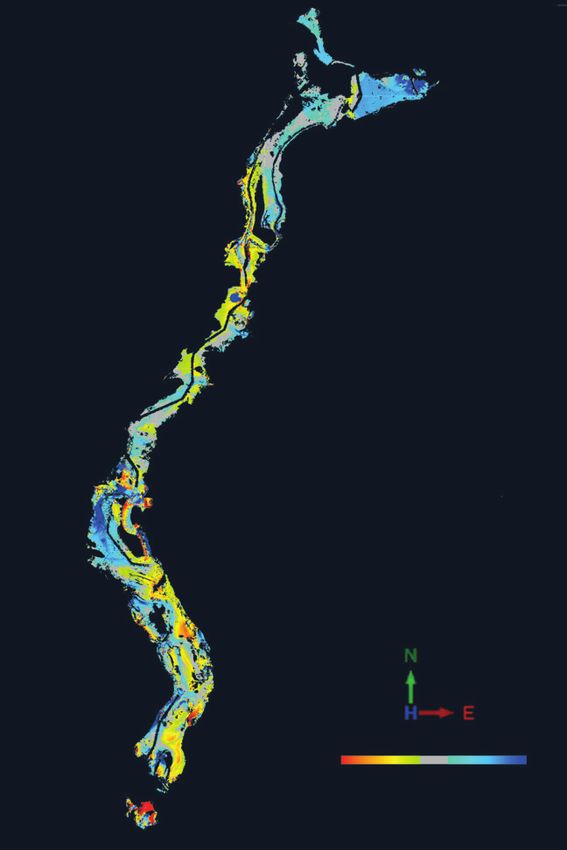
Buchroithner, Gaisecker / Ice surface changes in Eisriesenwelt based on LIDAR measurements between 2017 and 2020
Point attribute: Distance to surface
Gradient min/max: –0.200 0.200 m
Color below/above: Red Blue
Color gradient:
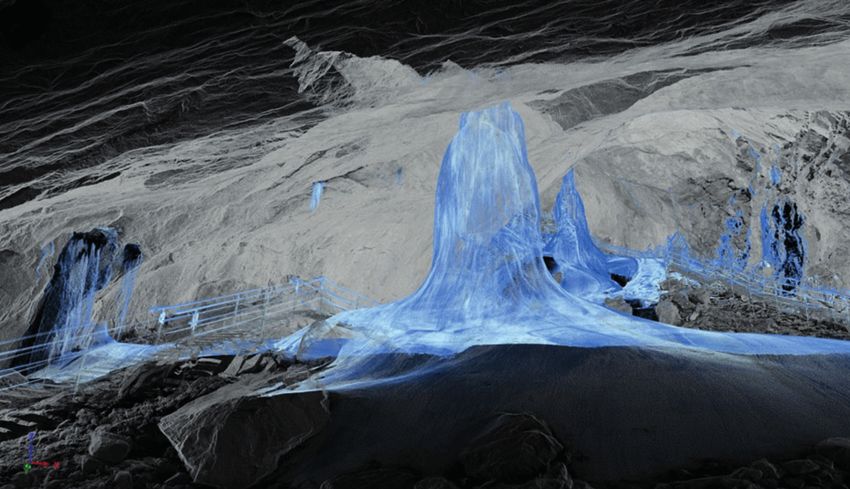
Fig. 7: Oblique view from above showing the increase and decrease of the ice surface between 2017 and 2019 in the central part
of the Posselthalle with its prominent central ice column. Turquoise-blue: ice increase, yellow-red: ice decrease. Visitor walkway
visible on the left side.
Abb. 7: Schrägansicht von oben, welche die Zu- und Abnahme der Eisdicke zwischen 2017 und 2019 im zentralen Teil der Posselt-
halle mit ihrer markanten Eissäule in deren Mitte zeigt. Türkis-Blau-Töne: Zunahme. Gelb-Rot-Töne: Abnahme. Links erkennt man
den Besucherweg.
LIDAR surveys (e.g., Milius & Petters, 2012) can be of these datasets finally got a new data attribute na-
explained by (i) the erroneously included surface of the med “distance to surface” which shows the distance
Eistunnel, (ii) changes in the laser wavelength, and (iii) along the normal vector of the reference data set to the
the considerable increase of the measurement range closest voxel of the reference data set. This attribute
(now several hundred metres) of the new LIDAR in- can be interpreted as increase or decrease of the ice
strument. The latter results in an improvement of the thickness within every voxel. Figure 7 shows an area
signal energy for the average scanned surface distance. within Posselthalle colourised according to ice growth
This is due to the fact that in 2019 and 2020 we used a and ice decrease. This method allowed a real three-di-
LIDAR instrument with a maximum range of 600 m for mensional data comparison with just a few mouse
distances which only extended up to some tens of me- clicks. Prior to our study, there were only a few points
tres. within the cave measured by ice stakes, showing the
In a next step voxels of the same size were extracted decrease respective increase of the ice cover at these
from the comparison datasets (2019, 2020). Every voxel individual points (Schöner et al., 2011).
CONCLUSIONS
The most recent LIDAR surveying campaign in the Eis- 2017 and April 2020) yielded an ice increase of 59 m³
riesenwelt end of April 2020 resulted in a total ice sur- (Fig. 9). This has to be seen in relation to the total ice
face of roughly 10,100 m². Compared to 2017, an area mass calculated by Kaidong (2018) based on ground-
of 2660 m² remained more or less constant, i.e. the penetrating radar measurements taken in April 2017,
average ice thickness changed by less than 3 cm. Ap- i.e. approximately 63,300 m³.
proximately 3860 m² showed an ice decrease of up to The flat area of the cave between Niflheim and Mörk-
30 cm (locally even more), whereas for about 3500 m² dom shows minor ice changes with smaller maximum
an increase of the same amount was measured. decreases and increases (Fig. 8, 9). We assume that the
The comparison of the overall mass balance of the Eis- reason is the flat topography with just a few small
riesenwelt between the two survey campaigns (April water inflows. The mass balance of this flat area
Die Höhle / 71. Jg. / Heft 1–4/2020 67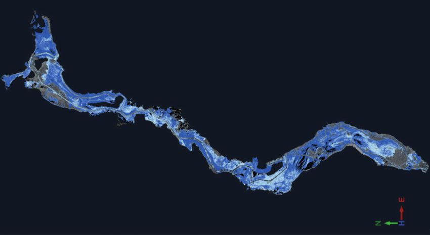
Buchroithner, Gaisecker / Ice surface changes in Eisriesenwelt based on LIDAR measurements between 2017 and 2020

                                                                                        Fig. 8: The ice-bearing part of the
                                                                                        Eisriesenwelt and comparison of
                                                                                        the ice surface height between
                                                –0.200         ±0.030      0.200 m      2017 and 2020.
                                                                                        Abb. 8: Der eisbedeckte Teil der
                                                 0                         100 m
                                                                                        Eisriesenwelt mit dem Vergleich
                                                                                        der Eisoberflächen zwischen 2017
                                                                                        und 2020.

yielded an ice decrease of 21 m³. The rearmost ice-            responsible for the very local ice growth areas in the
filled part of the cave, Eispalast, is also a flat area, but   lowest part of the cave, the Posselthalle, which is close
interestingly it shows a strong ice growth of 88 m³            to the cave entrance. Overall, however, the Posselthalle
(Fig. 8, 9).                                                   is dominated by ice decrease. Only the already men-
The first half of the show cave including Posselthalle,        tioned gravitational influence from ice growth in the
Großer Eiswall and Hymirburg shows a highly pro-               more northern, higher areas (Großer Eiswall and
nounced relief. From the entrance to Hymirburg the             Hymirburg) supports the overall mass balance in this
terrain is continuously ascending. At Hymirburg, just          lower part of the cave.
before the terrain turns flat, the maximum water in-           To sum up, the ice volume in Eisriesenwelt has increa-
flow occurs and is responsible for almost the whole ice        sed slightly even in recent years of increased global
growth within this steep southern half of Eisriesenwelt.       warming. Future LIDAR surveys will show whether this
Hymirburg and the upper part of Großer Eiswall show            is a multi-annual trend, providing important highly
a total of 64 m³ ice growth (Fig. 8). The ice increase in      resolved data for a better understanding of the long-
this area is a delayed gravity-driven reaction and is also     term ice mass balance in this cave.

68                                                                                   Die Höhle / 71. Jg. / Heft 1–4/2020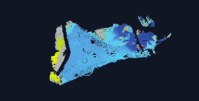
Buchroithner, Gaisecker / Ice surface changes in Eisriesenwelt based on LIDAR measurements between 2017 and 2020

                                                                                 Fig. 9: Detailed visualisation at
                                                                                 different scales. From top to
                                                                                 bottom: Eispalast, area between
                                                                                 Niflheim and Mörkdom, and
                                                                                 Hymirburg and upper part of
                                                                                 Großer Eiswall. For scale
                                                                                 comparison and colour
                                                                                 explanation see Fig. 8.
                                                                                 Abb. 9: Detaildarstellung in
                                                                                 verschiedenen Maßstäben. Von
                                                                                 oben nach unten: Eispalast, Gebiet
                                                                                 zwischen Niflheim und Mörkdom,
                                                                                 und Hymirburg und oberer
                                                                                 Abschnitt des Großen Eiswalls.
                                                                                 Maßstab und Farblegende wie in
                                                                                 Abb. 8.

Die Höhle / 71. Jg. / Heft 1–4/2020                                                                            69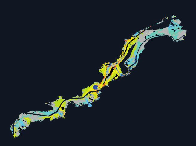
Buchroithner, Gaisecker / Ice surface changes in Eisriesenwelt based on LIDAR measurements between 2017 and 2020

ACKNOWLEDGEMENTS
The authors thank the editors for their valuable comments.

REFERENCES
Buchroithner, M.F. (2015): Mountain Cartography ’down         Milius, J. & Petters, Ch. (2012): Eisriesenwelt – From Laser
   under‘ – Speleological 3D Mapping. – In: K. Kriz (Ed.),       Scanning to Photo-Realistic 3D Model of the Biggest Ice
   Mountain Cartography. 16 Years ICA Commission on              Cave on Earth. – In: Jekel, T., Car, A., Strobl, J. &
   Mountain Cartography (1999-2015). – Wiener Schriften          Griesebner, G. (Eds.): GI_Forum 2012: Geovizualisation,
   zur Geographie und Kartographie, 1/2015, 21: 191–198.         Society and Learning. – Berlin (Wichmann): 513–523.
Buchroithner, M.F., Milius, J. & Petters, Ch. (2011): 3D      Petters, Ch. (2012): Eisriesenwelt: Processing Steps from
   Surveying and Visualization of the biggest Ice Cave on        Laser-Scanner Point Cloud to a Photorealistic Three-
   Earth. – Digital Proceedings 25th International               Dimensional Model of the World’s Largest Ice Cave and
   Cartographic Conference, Paris, 3–8 July, CO-015: 6.          Presentation on an Autostereoscopic 3D Display. –
Kaidong, A. (2018): Ice Basement Mapping of Eisriesenwelt        Unpublished Diploma Thesis. TU Dresden.
   Cave with Ground Penetrating Radar. – MSc Thesis, TU       Schöner, W., Weyss, G. & Mursch-Radlgruber, E. (2011):
   Dresden.                                                      Linkage of cave-ice changes to weather patterns inside
Milius, J. (2012): Processing Steps of TLS from Point Cloud      and outside the cave Eisriesenwelt (Tennengebirge,
   to 3D Model of the Largest Ice Cave on Earth, the             Austria). – The Cryosphere, 5: 603–616.
   Eisriesenwelt. – Unpublished Semester Thesis. TU
   Dresden.

ZUSÄTZLICHE ELEKTRONISCHE DATEN
                       Unter dem link https://www.youtube.com/watch?v=yxVWNjO12Og ist ein Video zum
                       Laserscanprojekt in der Eisriesenwelt abrufbar.

70                                                                                   Die Höhle / 71. Jg. / Heft 1–4/2020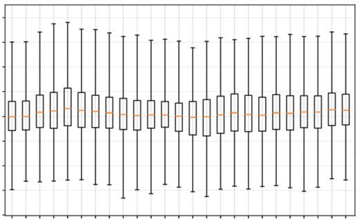
You can also read