EMO Hurricane Season Briefing 2019 - Bermuda Weather ...
←
→
Page content transcription
If your browser does not render page correctly, please read the page content below
EMO Hurricane Season Briefing 2019

  Presented by Michelle Pitcher, Deputy Director, BWS:
1.BWS oversight & coordination
2.Tropical Cyclone Development & Characteristics
3.NHC Verification Trends
4.BWS Role, Actions and Liaisons

        Presented by James Dodgson, Director, BWS:
1.   Review of 2018 Hurricane Season
2.   2019 Hurricane Season forecast
3.   Tropical Cyclone Climatology specific to Bermuda
4.   BWS communications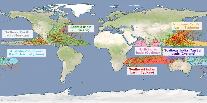
Coordination
                          Bermuda Airport Authority
                    (Bermuda Airport Authority Act 2017)

                                                          Disaster Risk Reduction
       Skyport                                               & Mitigation Team
• Aviation Forecasts, Watches                                (BDA Government)
  & Warnings              Tropical Updates, Watches, & Warnings
• NOTAMs & Flight Plans
• www.weather.bm/aviation                    • Severe Weather Watches & Warnings
                      •   Public & Marine Forecasts, Watches & Warnings
                      •   Yacht Charts & Briefings
                      •   www.weather.bm
                      •   Media (TV Channels, Radio & Newspaper)
                      •   Climatology
Tropical Cyclone Formation Basins

                          Source http://www.srh.noaa.gov/jetstream/tropics/tc_basins.htm

 These are between 5-15 degrees latitude north &
south from the equator and generally tend to move
 east to west as the hurricanes develop and grow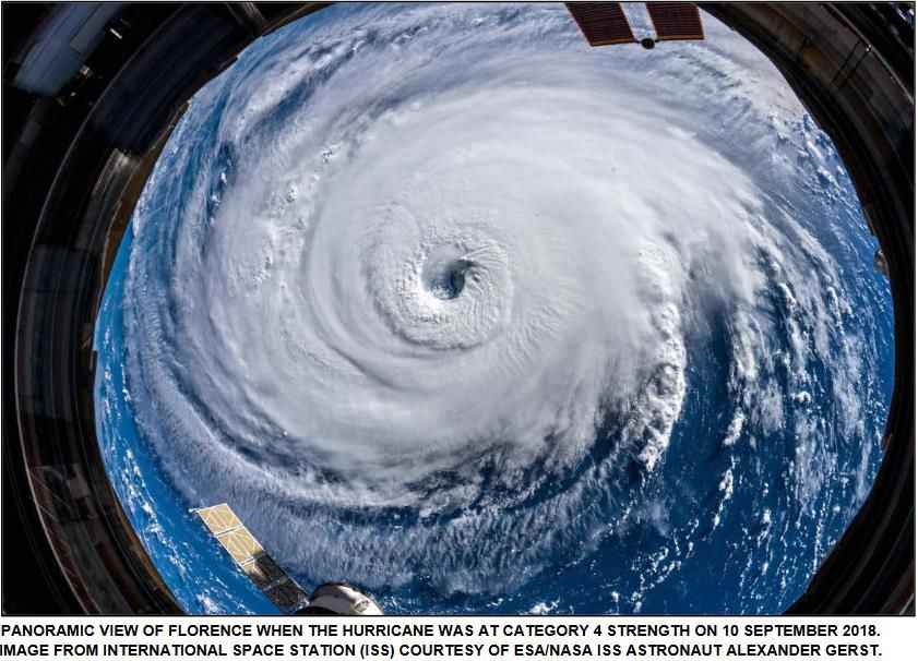
Tropical Cyclone Terminology

• *Tropical Depression - A tropical cyclone in which the maximum sustained
  surface wind speed (using the U.S. 1-minute average) is 33 knots or less.

• *Tropical Storm - A tropical cyclone in which the maximum sustained surface
  wind speed (using the U.S. 1-minute average) ranges from 34 to 63 knots.

• Hurricane - A tropical cyclone in which the maximum sustained surface wind
  (using the U.S. 1-minute average) is 64 knots or higher.

• Major Hurricane - A hurricane that is classified as Category 3 or higher, 96 knots
  and higher
                    *Also includes Sub-Tropical Storms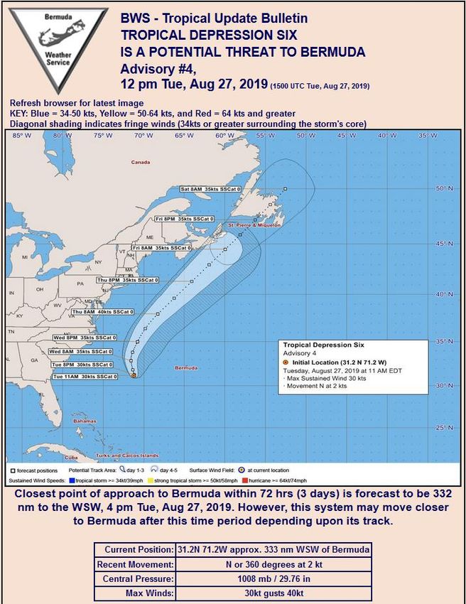
+
    65-80 Years   2-7 Years
-
El Nino & La Nina – impact on Tropical Cyclone
                  formation

                                             El Nino suppresses Atlantic
                                             hurricane development

                                             La Nina enhances Atlantic
                                             hurricane development

                   Images courtesy of NOAA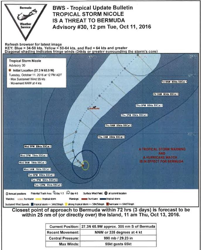
Tropical Cyclone Formation

Main Development
 Region (MDR)

    • Warm sea surface temperature (at least 26C/80F)
    • Moist & Unstable atmosphere      •Low wind shear environment
    • Pre-existing Disturbance
       • e.g. Tropical Wave, old cold front, upper-level low/trough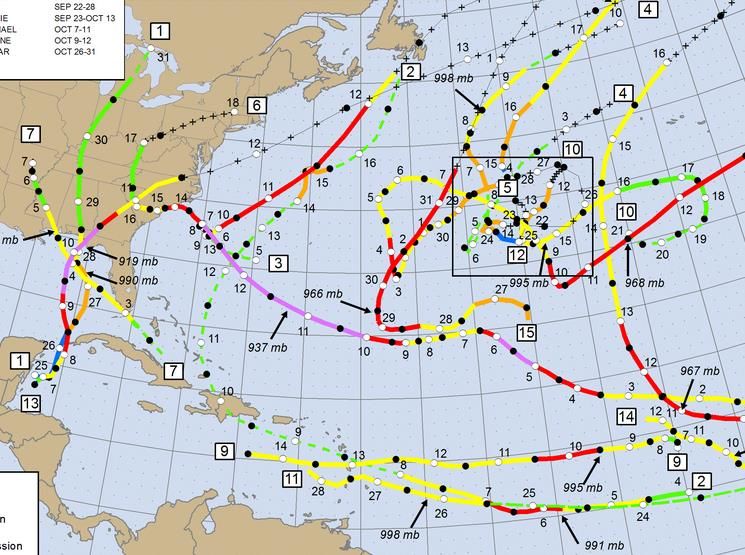
Tropical Cyclone Formation
Tropical Wave in the Easterlies
Hurricane Development

    This feedback mechanism continues as long as the
favorable conditions for hurricane growth continue to exist.
Major Hurricane Nicole SUOM 1 NPP VIRS Day Night Band 13 Oct 2016 06:15Z
Hurricane Winds & Storm Surge

Weaker winds
      on
 the left side
of the storm                       Storm Surge is a dome of water driven
                                       by the persistent strong winds

                   Strongest winds
                   on the right side
                     of the storm
National Hurricane Center – Atlantic Basin
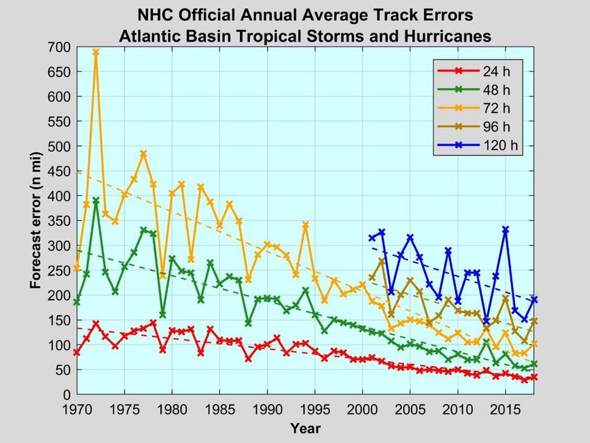
NHC Performance Measures and Goals: Track & Intensity

• As of 9 May 2019
NHC Performance Measures and Goals: Track & Intensity

• As of 9 May 2019                             Per NHC:
                                               • Intensity is usually
                                                 estimated and not directly
                                                 measured
                                               • Winds damages land
                                                 stations
                                               • NOAA dropsondes sample
                                                 portions of entire cyclone
                                               • Data is readily available
                                                 over land, but not over
                                                 the ocean
                                               • Greater influence from
                                                 environmental
                                                 interactions
                                               • Tends to be conservative
                                               • “New” GOES16 will
                                                 provide new data for
                                                 intensity models;
                                                 increasing skill
BWS, in conjunction with NHC, Responsible for Local Threats,
Watches, and Warnings
Distance of Centre
• Potential Threat: The centre of a tropical cyclone is
forecast to come within 400 nautical miles of Bermuda
within 72 hours.
• Threat: The centre of a tropical cyclone forecast to
come within 100 nautical miles of Bermuda OR the
effects of the tropical cyclone are possible in 72 hours.
Wind Speeds
• (*TS) Hurricane Watch: Possible onset of (TS 34-63
knots) Hurricane force (64+ knots) winds within 48
hours or less.
• (*TS) Hurricane Warning: Possible onset of (TS 34-63
knots) Hurricane force (64+ knots) winds within 36
hours.
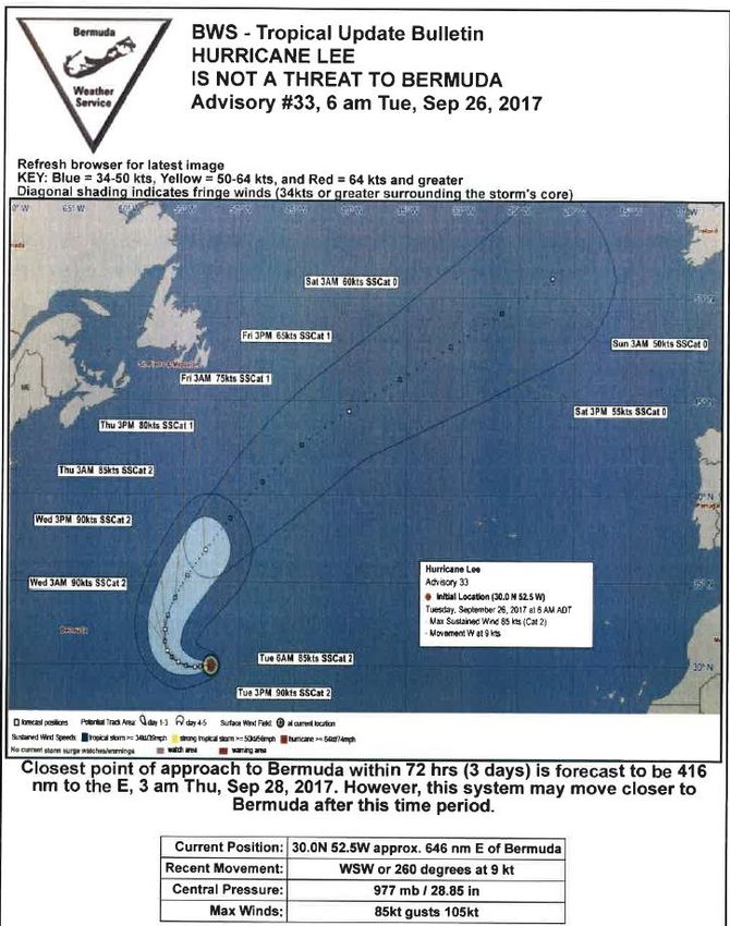
* Also includes: Sub-Tropical StormsNo Threat: Hurricane Lee
40N 400nm
100nm
T+72 hrs
30N
T+0 hrs
20N
70W 60W 50WPotential Threat: Tropical Depression Six
40N 400nm
100nm
30N
The centre of a tropical system is
forecast20Nto come within 400
nautical miles of Bermuda within 72
70W hours.60W 50WThreat: Hurricane Nicole
40N 400nm
100nm
30N
The centre of a tropical system is forecast
to come within
20N 100 nautical miles of
Bermuda within 72 hours.
70W 60W 50WImplementation
T + 72 hours BWS monitoring NHC & other agencies for information Liaison with
DRRMT, BAA, Skyport on tropical cyclones moving towards BDA as necessary
T = 72 hours Cyclone deemed (Pot.)Threat, Email to: DRRMT, BAA, Skyport, MAROPS,
Briefings in person and via video begin
T = 48 hours TS/HURCN Watch issued, email updates and briefings continue, EMO Meeting
T = 36 hours TS/HURCN Warning issued, email updates and briefings continue
T - 36 → 0 hours Continued updates, forecast wind onset and cessation time tables
created exclusively for the marine area, the Island, and the AirportImplementation
CPA Potential for the strongest winds, highest swells/surge, passage of
the eye
Winds < 64 knots HURCN Warning downgraded to TS
Winds < 34 knots TS Warning downgraded to Small Craft Warning
All Clear Final communications to EMO, BAA, Skyport, & MAROPS
NB: BWS staff stay at the office for the duration of
the event; maintaining continuity of our 24 hour
operationsEMO Hurricane Season Briefing
1. Review of 2018 hurricane season
2. 2019 hurricane season
• Predictions (including season so far)
• Atlantic & Bermuda tropical climatology
• BWS communications
James Dodgson jdodgson@airportauthority.bm
Director, Bermuda Weather Service (BWS), a
Section of the Aviation Services Delivery Unit,
Bermuda Airport AuthorityReview of 2018 Hurricane Season
Very active in the central Atlantic
and along parts of the US Gulf
coast (e.g. Major Hurricane
Michael) as well as the US eastern
Seaboard (Major Hurricane Florence)
BDA
Despite some agencies forecasting
an average or below average season,
there were no less than 15 named
storms, compared to an average of 12
However, for Bermuda, it was another
welcome quiet season, with NO
Tropical watches/warnings issued
Image courtesy of NOAA/NHCReview of 2018 Hurricane Season
September 12th -
HURCN Florence Cat 3
HURCN Helene Cat 1
TS Isaac
STS Joyce
Joyce
BDA
Florence
Helene
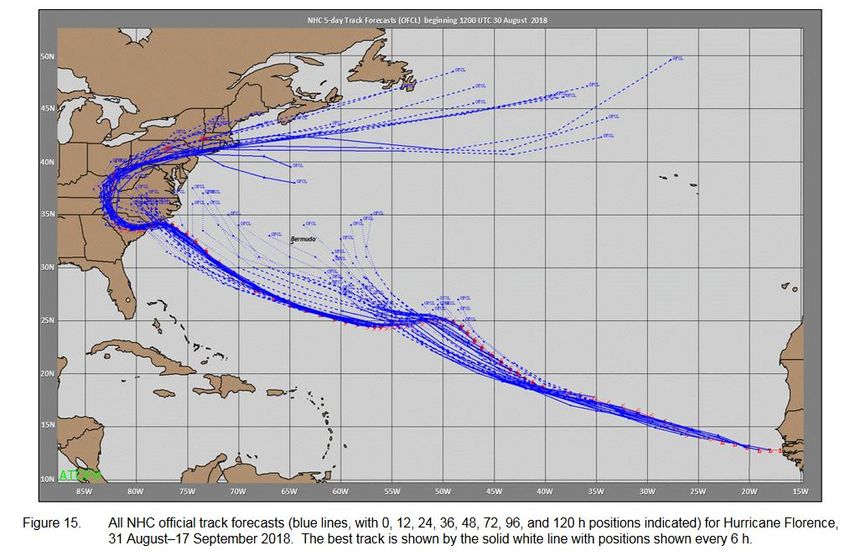
IsaacHurricane Florence – forecast challenges
Atlantic Hurricane Season Summary 2018(& 2017)
ATLANTIC SEASONAL HURRICANE FORECAST FOR 2015

 Forecast             Climatology           Last year’s tally,     Previous year, 2017
 Parameter            (average 1981-        2018
                      2010)

 Named Storms                  12                     15                    17

 Hurricanes                    6                       8                    10

 Major Hurricanes              3                       2                    6

WHY increased activity? Despite forecasting agency projections suggesting near or just
below average, last year was above average, largely due to poorly forecasted warming
SSTs in August, as well as a slower than expected El Nino development.
2017 was very active due to a developing La Nina.

Despite these two active years, Bermuda was not directly impacted by any tropical
cyclones, with no watches/warnings issued for first time since 2007!
2019 Hurricane Season 1. 2019 Seasonal Forecast - season so far & latest August update 2. Atlantic & Bermuda Tropical Climatology 3. BWS communications with EMO before, during and after a tropical system affecting BDA
2019 Hurricane Season – current stats

  ACE is the measure
  of all the energy
  associated with a
  Tropical cyclone.
  It stands for:
  Accumulated
  Cyclone
  Energy

                              Current ACE is
                              5 compared
                              with seasonal
                              average of 20

                         Image courtesy of Colorado State
2019 Hurricane Season – current stats
STS Andrea caught BWS’s
attention ahead of official
start of season – no impact
Hurricane Barry caused
extensive damage to Lafayette,
Lake Charles, and Baton Rouge
All systems rather short-
lived, not generating much
ACE
Image courtesy of WikipediaAtlantic Seasonal Hurricane Forecast 2019
ATLANTIC SEASONAL HURRICANE FORECAST FOR 2015
Forecast Climatology Tropical Colorado NOAA CPC UK Met Office
Parameter (average Storm Risk State issued issued issued
1981-2010) issued 5 August 8 August 21 May
6 August
Named 12 13 14 14 13
Storms
Hurricanes 6 6 7 7 7
Major 3 2 2 3 3
Hurricanes
Why are forecast numbers slightly above average for this season?
Recent El Nino event has now ended. El Nino typically suppresses Atlantic
hurricane activity but now that’s gone, we are likely to see a slightly above
average season ahead. This is coupled with the current on-going era of more
conducive conditions (positive phase of the AMO – warmer SSTs) since 1995.
REMEMBER, what ever the projections are, it only takes one storm to make it
an active season for us! E.g. Hurricane Nicole
The very fact that NO tropical watches/warnings were issued by BWS in the
last two seasons makes it increasingly likely BWS will issue some this season!Tropical Climatology of Atlantic - August
BDA
Images courtesy of NOAATropical Climatology of Atlantic - September
BDA
Images courtesy of NOAATropical Climatology of Atlantic - October
BDA
Images courtesy of NOAATropical Climatology of Atlantic - November
BDA
Images courtesy of NOAAHistorical Record For Atlantic Basin
12-13 October 2016
Major Hurricane Nicole
4-5 October 2015
Hurricane Joaquin
17 October 2014
Major Hurricane
Gonzalo
12 October 2014
Hurricane FayHistorical Record For Bermuda (Hurricanes)
Historical Record For Bermuda (Tropical Storms & Hurricanes)

                                44

                                     34
Timeline for Threats, Watches and Warnings
Creation
of TUBs
Threat
consideration
Email to EMO Cessation of
executive Issuance of Cessation of Final
POTENTIAL TS force
Likely Issuance Potential for hurcn force winds. TS communication
convening of THREAT Onset of winds. HURCN between BWS &
of strongest WARNING
EMO as (400nm) or Issuance of EMO to give all clear
THREAT TS/HURCN
TS/HURCN TS/Hurcn winds/swells/ WARNING downgraded
directed by WARNING force surge and eye downgraded to to Small Craft – EMO post event
NDC (100nm) WATCH winds TS WARNING meeting as required
passage warning
Time=>
>T-72hrs T-72hrs T-48hrs T-36hrs T-0hrs CPABWS Operations
• www.weather.bm
• Automated telephone recordings 977,
9771, 9772, 9773
• Radio interviews (including 100.1FM)
• Marine VHF Channel 2 (Bermuda
Radio)
• OneComm Channel 4 & WOW Channel
100 BWS Weather Channels
• Social Media – BWS Facebook page:
www.facebook.com/BermudaWeather
Service
• News media announcements
• Communications with EMO, Aviation & Marine operations via email,
fax, phone, satellite phone BWS # +881 631 452 873
• Full redundancy for BWS equipment, electricity & commsBWS Operations
Additional information provided to EMO
•   BWS director will email the EMO executive email group when a system is expected to
    affect BDA in any way – Regiment contacts are also included
•   Weather briefings provided to the EMO as needed in advance of a warning issuance
•   Before, during and after the event, information will be conveyed via email to the EMO
    executive email group (NDC then re-distributes the information to wider membership)
     – Onset/cessation and directions of winds reaching the following thresholds:
           • 34 knots (Tropical Storm force)
           • 50 knots (potential Causeway &/or Airport closure, depends on multiple
             variables including wind direction, tide cycle, time of day, forecast etc.)
           • 64 knots (Hurricane)
     – Maximum wave heights expected & the effects due to storm surge/tidal levels
     – Time and distance of the closest point of approach of the centre of the storm
•   Online Video briefings - produced by BWS when the EMO cannot convene, e.g. during the
    event or on weekends/short notice events or during preparation.
Onset/cessation
Title
Wind Timings (example)
24 hours
15 hours
12 hours
** 4 hrs Cat3
- Cat2
Eye approx. 45 minHow can we improve for 2019 Season?
• United front of Information- EMO, DC & BWS
• Communication
– BWS – Impact based & colour coded for government
department planning. Did this help last few years? Should we
continue? – NHC & WMO pushing impact based forecasting in future –
e.g. high rainfall versus flood/surge warning
BLUE – Sea state event: Parks (Lifeguards)
YELLOW – 50 kt threshold: Parks, Education, Transport, Causeway, etc
RED – Damages possible – All departmentsHPW19 – Hurricane Preparedness Week 2019
• Ran from June 3rd – 7th 2019
• In collaboration with the Disaster Risk Reduction Mitigation Team
• Press release issued; various links/videos on www.weather.bm/HurPWeek.asp
• Asking the public to: Please do not become complacent
– Please review/create a Hurricane Preparedness Plan
• for your family and business incorporating lessons from recent years
– Tropical systems do not behave like winter weather – they can change very
rapidly. At the watch stage, please monitor the progress carefully at the
warning stage please respond to preparations
• Keep updated on the official sources of information
– www.weather.bm maintained by BWS, a 24hr local operation & updated
routinely – every 3 hours in tandem with NHC advisories (in threat)
• for Bermuda’s official weather forecast, Watches & Warnings
– www.gov.bm for preparation (also the Tree Frog app)
– Emergency Broadcast Facility (100.1FM) during eventThank-you. Any questions?
Aderonke Bademosi Wilson
   Director, Department of
    Communications
Government of Bermuda’s Treefrog
appAbout the app • Designed by four students at Bermuda College with support from the Portals Management team, Information and Digital Technologies Department and a US app developer and project managed from the Cabinet Office; • Launched in April; • Designed to provide users with press releases, alerts and notifications that are issued by the Department of Communications.
Downloading the App
•   It is free, easy and user-friendly
•   Download from the App store or Google Play
•   Look for Bermuda Treefrog
•   You can select which categories you want to
    receive information about:
    –   Announcements
    –   Government closures
    –   Health
    –   Service Disruptions
    –   Traffic
During an emergency • The option you cannot turn off is Public Safety • Before, during and after a hurricane, Communications Officers will send out notices to the media and the information will be immediately posted to the website and pushed to Treefrog • Treefrog will give users direct access to information and updates about the hurricane. • This information will also be posted on social media.
Questions?
BWS Website updates – New Radar and AWOS
(Automated Weather Observing System) products
You can also read