Unified Forecast System: Advancing NCEP Operational Global Modeling Systems for 2021 and Beyond
←
→
Page content transcription
If your browser does not render page correctly, please read the page content below
Unified Forecast System: Advancing
               NCEP Operational Global Modeling
               Systems for 2021 and Beyond
NATIONAL       Tropical Cyclone Operations and Research Forum, March 4, 2021
WEATHER
               Vijay Tallapragada, Ph.D.
SERVICE        Chief, Modeling and Data Assimilation Branch, NOAA/NWS/NCEP/EMC

NATIONAL WEATHER SERVICE                                Building a Weather-Ready Nation // 1
Outline
•   Implementation of UFS Sub-Seasonal Application (GEFSv12,
    September 23, 2020)
•   Upgrades to UFS Medium-Range Weather Application (GFSv16,
    March 17, 2021)
       •   Assimilation of HDOBS and improved use of dropsonde data in
           GFSv16
•   Addition of Commercial RO Data in GFSv16.1 (May 2021)
•   UFS-R2O Project
•   Fully coupled UFS MRW/S2S Forecast System for FY24
    (GFSv17/GEFSv13)

NATIONAL WEATHER SERVICE                          Building a Weather-Ready Nation // 2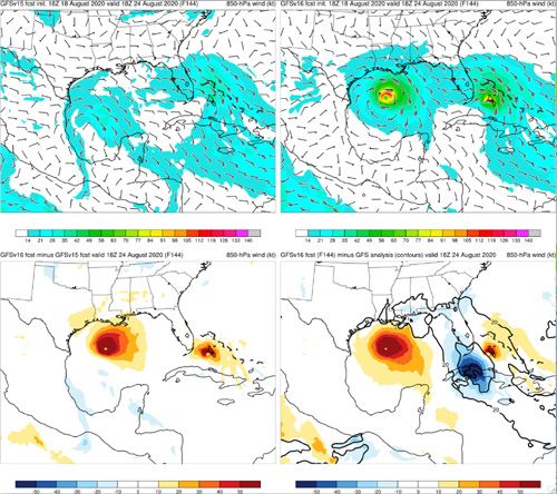
NPS Transitioning to UFS Applications

Conceptual UFS
applications in
production covering
all NPS applications.

Components of UFS
are configured to
develop distinct
applications while
maintaining the
dependencies
between the
applications and
products

 NATIONAL WEATHER SERVICE                 Building a Weather-Ready Nation // 3
GFS.v15.2 Transitioned to Operations on November 6, 2019
 New Observations:
 ● Assimilate GOES-17 AMVs
 ● Assimilate Metop-C AMSU and MHS
 ● Assimilate KOMPSAT-5 (GPS-RO)
 ● Assimilate buoyb sst data
 ● Ingest VIIRS AMV data using new format

 GFSv15.3 Transitioned to Operations on May 26 ,2020
 New Observations:
 ● Assimilate GNSS-RO COSMIC-2
 ● Assimilate METOP-C GRAS and IASI

 NATIONAL WEATHER SERVICE                   Building a Weather-Ready Nation // 4
GEFS.v12: First FV3 based UFS Sub-Seasonal Global Ensemble
Forecast Application (Implemented on Sept. 23, 2020)

  Global Ensemble Forecast                     •   Configuration
  System GEFS v12                                   •   C384L64 (~25km); L64; GFSv15 physics
          Hurricane Florence, 2018                  •   31 members, 4 cycles/day, 35 days forecasts
                                                        at 00Z and 16-day at 06/12/18Z
                                                    •   Uniform resolution throughout the forecast
                                                        period
                                                    •   No TC relocation
                                                    •   One-Way coupling to waves (Global Wave
                                                        Ensemble System) and chemistry (NEMS GFS
                                                        Aerosol Component)
                                                    •   Physics perturbations using SPPT, SKEB; and
                                                        GDAS 6-hr EnKF for IC perturbations, 2-tiered
                                                        SSTs driven by CFSv2 forecasted SSTs
  Significant improvement in ensemble spread   •   20 years (1999-2018) reanalysis; 30 years (1989-
                                                   2018) reforecast; Retrospective runs (3.5 years)
  NATIONAL WEATHER SERVICE                                                 Building a Weather-Ready Nation // 5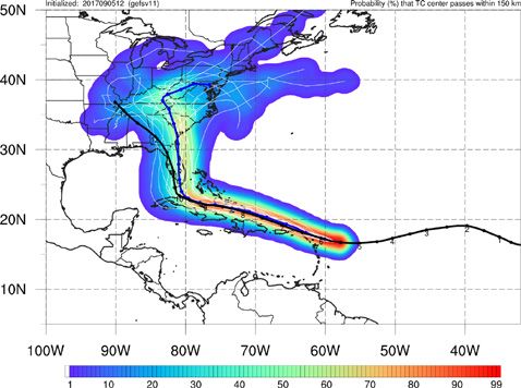
GEFSv12 TC track verification
                            2017: 00Z 06/01----11/30 ; 12Z 07/01----10/31

  Atlantic basin            2018: 00Z 05/01----11/30; 12Z 07/01----10/31

                            2019: 00Z 05/01----11/30; 12Z 07/01----10/31

 East Pacific basin          West Pacific
                               basin

NATIONAL WEATHER SERVICE                  Building a Weather-Ready Nation // 6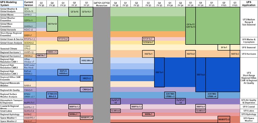
GEFSv12 TC intensity verification
                                 2017: 00Z 06/01----11/30; 12Z 07/01----10/31

                                 2018: 00Z 05/01----11/30; 12Z 07/01----10/31

           Atlantic basin        2019: 00Z 05/01----11/30; 12Z 07/01----10/31

         East Pacific basin                West Pacific basin

NATIONAL WEATHER SERVICE                       Building a Weather-Ready Nation // 7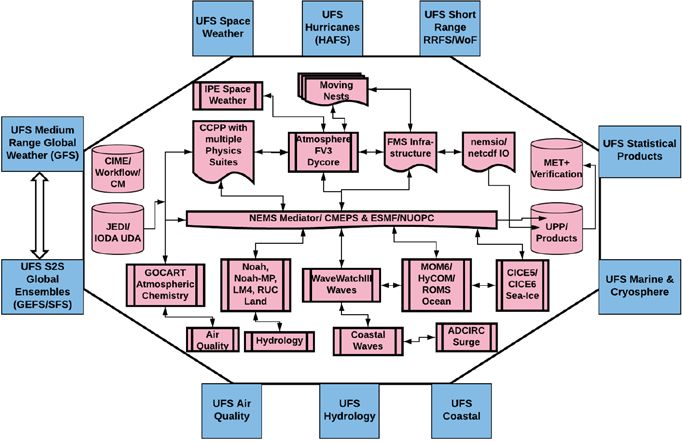
TC Count and Tracks: Anomaly Correlations - WNP
                           • GEFS outperforms the other
                             models in Weeks 1-2 and is
                             on par with CFS in weeks 3-4.

                                              • Years of Note
                                              • Good: 2004,
                                                2005?
                                              • Bad: 2006

NATIONAL WEATHER SERVICE                Building a Weather-Ready Nation // 8   8
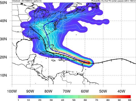
Concerns: TC Right-of-Track Bias

                                           Irma
                                    Init: 12Z 9/05/17

    GEFSv11                                             GEFSv12

  GEFSv11 is in good agreement with Best Track at shorter lead times, but becomes right
of Best Track at longer lead times. GEFSv12 is further right than GEFSv11 at all lead times.

NATIONAL WEATHER SERVICE                                          Building a Weather-Ready Nation // 9
NATIONAL OCEANIC AND ATMOSPHERIC ADMINISTRATION

              GDAS/GFSv16.0 to be implemented on March 17, 2021
•   Increase the vertical resolution (long awaited) and advanced physics to enhance the model representation
    of the atmosphere, improve the DA algorithms, and include more observations (satellite and in-situ) for
    better initial conditions
•   Couple the deterministic global wave model with the atmospheric model using the UFS coupling
    framework (simplification of production suite)

•            priorities: Improve the forecast skill while addressing known issues from GFSv15
    Scientific
    evaluation
    •   Excessive cold bias in the winter season
    •   Progressive bias for synoptic scale systems
    •   Less skillful TC track forecasts, especially for stronger storms
    •   Low bias for stratospheric temperature forecasts
    •   Precipitation dry bias for moderate rainfall
    •   Poor representation of boundary layer inversions

•   Improve products and add new variables requested by the users
•   Conduct comprehensive testing and evaluation including downstream models to demonstrate the
    benefits of this upgrade
                                                                                                           10
NATIONAL OCEANIC AND ATMOSPHERIC ADMINISTRATION
Change History of GFS Configurations
Mon/Year Lev Truncations Z-cor/dyncore Major components upgrade
Aug 1980 12 R30 (375km) Sigma Eulerian first global spectral model, rhomboidal
Oct 1983 12 R40 (300km) Sigma Eulerian
Apr 1985 18 R40 (300km) Sigma Eulerian GFDL Physics
Aug 1987 18 T80 (150km) Sigma Eulerian First triangular truncation; diurnal cycle
Mar 1991 18 T126 (105km) Sigma Eulerian
Aug 1993 28 T126 (105km) Sigma Eulerian Arakawa-Schubert convection
Jun 1998 42 T170 (80km) Sigma Eulerian Prognostic ozone; SW from GFDL to NASA
Oct 1998 28 T170 (80km) Sigma Eulerian the restoration
Jan 2000 42 T170 (80km) Sigma Eulerian first on IBM
Oct 2002 64 T254 (55km) Sigma Eulerian RRTM LW;
May 2005 64 T382 (35km) Sigma Eulerian 2L OSU to 4L NOAH LSM; high-res to 180hr
May 2007 64 T382 (35km) Hybrid Eulerian SSI to GSI
18 years ! Jul 2010 64 T574 (23km) Hybrid Eulerian RRTM SW; New shallow cnvtion; TVD tracer
Jan 2015 64 T1534 (13km) Hybrid Semi-Lag SLG; Hybrid EDMF; McICA etc
May2016 64 T1534 (13km) Hybrid Semi-Lag 4-D Hybrid En-Var DA
Jun2017 64 T1534 (13km) Hybrid Semi-Lag NEMS GSM, advanced physics
Jun 2019 64 FV3 (13km) Finite-Volume NGGPS FV3 dycore, GFDL MP
Feb 2021
127 FV3 (13km) Finite-Volume IAU, LETKF, TKE-EDMF, uGWD
11NATIONAL OCEANIC AND ATMOSPHERIC ADMINISTRATION
GFSv16: Major Changes to the Forecast Model
Model resolution:
Increased vertical layers from 64 to 127 & raised model top from 54 km to 80 km
Physics updates:
PBL/turbulence: Replaced K-EDMF with sa-TKE-EDMF (Revised background diffusivity as a stability dependent
function)
GWD: Added a parameterization for subgrid scale nonstationary gravity-wave drag
Radiation: Updated calculation of solar radiation absorption by water clouds; Updated cloud overlap
assumptions.
Microphysics: Updated GFDL microphysics scheme for computing ice cloud effective radius
Noah LSM: Revised ground heat flux calculation over snow covered surface; Introduced vegetation impact
on surface energy budget over urban area
Coupling to Wave Model:
One-way coupling of atmospheric model with Global Wave Model (WaveWatch III, Multi_1)
12NATIONAL OCEANIC AND ATMOSPHERIC ADMINISTRATION
Major Upgrades to GDAS
• Local Ensemble Kalman Filter (LETKF) with • Assimilate CSR data from ABI_G16, AHI_Himawari8,
model space localization and linearized observation and SEVIRI_M08; AVHRR from NOAA-19 and Metop-B
operator for NSST
to replace the Ensemble Square Root Filter • Assimilate additional GPSRO (add Metop-C GRAS, More
(EnSRF) Cosmic-2)
• 4-Dimensional Incremental Analysis Update (4D- • Assimilate high-density flight-level wind, temperature,
IAU) and moisture observations (HDOBS) in tropical storm
• Turn on SKEB in EnKF forecasts environment (first time in operations for GFS)
• New variational QC • Reduce the distance threshold for inner core dropsonde
• Apply Hilbert curve to aircraft data data to 55km (from 111km or 3*RMW) and add a wind
• Correlated observation error for CrIS over sea surfaces threshold of 32 m/s to allow more dropsonde data
and IASI over sea and land being assimilated
• Update temperature aircraft bias correction with • Use CRTM v2.3.0
safeguard
• Assimilate AMSU-A channel 14 and ATMS channel 15
w/o bias correction
13NATIONAL OCEANIC AND ATMOSPHERIC ADMINISTRATION
Strengths: Improved Medium-Range Track Error
North Atlantic Track Error (nm) East Pacific Track Error (nm)
for TCs ≥65 kt for TCs ≥65 kt
GFSv15 GFSv15
GFSv16 Images provided
GFSv16
by Jiayi Peng
GFSv16 has lower track error than GFSv15 for strong TCs (≥65 kt) during most
of the medium range in both the North Atlantic and East Pacific 14NATIONAL OCEANIC AND ATMOSPHERIC ADMINISTRATION
Strengths: Improved TC Intensity in N Atlantic
North Atlantic Intensity Error (kt) North Atlantic Intensity Bias (kt)
Strong
GFSv15 GFSv16
Weak
GFSv15
GFSv16
Images provided
by Jiayi Peng
GFSv16 has lower intensity error than GFSv15 at almost all lead times in the N Atlantic
GFSv16 has less of a weak bias than GFSv15 at longer lead times 15NATIONAL OCEANIC AND ATMOSPHERIC ADMINISTRATION
Concerns: Increased Right-of-Track Bias
N Atlantic Along-Track Bias N Atlantic Across-Track Bias
Right
Fast
GFSv16
GFSv15
GFSv15
GFSv16
Slow
Left
Images provided
A slower and right-of-track bias at longer lead times suggests by Jiayi Peng
that GFSv16 may be recurving TCs earlier than GFSv15
GFSv16 has a larger slow bias than GFSv15 that grows with forecast length in the N Atlantic
GFSv16 has a larger right-of-track bias than GFSv15 that is largest at longer lead times 16NATIONAL OCEANIC AND ATMOSPHERIC ADMINISTRATION
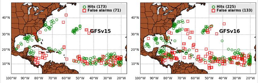
Larger TC False Alarm Rate
From Dan Halperin, ERAU
A further left
than the of the
same color indicates
that v16 has a higher
false alarm rate for
that season
While preliminary
2020 numbers look
good for v16, the
weighted mean for
the three TC
seasons shows that
v16 has a larger FAR
17NATIONAL OCEANIC AND ATMOSPHERIC ADMINISTRATION
Larger TC False Alarm Rate
From Dan Halperin, ERAU
Large number of false alarms in GFSv16, relative to v15, between 50º and 70º W
18NATIONAL OCEANIC AND ATMOSPHERIC ADMINISTRATION
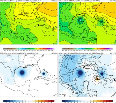
Concerns: Strengthens Too Many TCs
TCs Laura/Marco
Fcst: 18z 08/18/20(F144)
Valid: 18Z 08/24/20
• Marco: GFSv16 had better track
GFSv15 GFSv16 forecasts, but 15 consecutive v16
cycles had Marco as a sub 982 low
(with many in the 950s and 960s);
no GFSv15 cycle was that intense
• Laura: GFSv16 did well with many
aspects of the intensity forecast,
but this example shows a major
v16−v15 GFS Anl. threat to south FL that did not
materialize 19NATIONAL OCEANIC AND ATMOSPHERIC ADMINISTRATION
Impact of Assimilation of HDOBS & improved use of dropsondes
Significant improvements in track and intensity forecasts, especially for strong storms
(About 20% more dropsonde data, and about 800 more HDOBS data (u,v,t,q) per cycle)
20GFS.v16.1 Planned for implementation in May 2021 New Observations: ● Assimilation of commercial RO data which will become available by March 2021 ● Addition of Metop-C IASI data that will start flowing into operations and possibly become the primary/operational satellite from EUMETSAT (replacing the aging metop-a) ● GOES AMV quality marks will need to be updated in response to the heat-pipe cooling issues to take better advantage of AMVs during problematic periods NATIONAL WEATHER SERVICE Building a Weather-Ready Nation // 21
Notional Post-WCOSS Moratorium Implementations

 NATIONAL WEATHER SERVICE          Building a Weather-Ready Nation // 22
R2O Project
         https://ufscommunity.org/ufsr2oproject/

 Vijay Tallapragada, Jeff Whitaker, Jim Kinter

NATIONAL WEATHER SERVICE               Building a Weather-Ready Nation // 23
UFS-R2O NWS/OSTI OAR/WPO
Whitaker, Tallapragada, Kinter Koch, Melendez, Kondragunta
Project Engineer
Adimi, Flampouris, Kumar
MRW/S2S SRW/CAM Cross-cutting Infrastructure
Stan, Yang, Alexander, Carley, Dunlap, Jensen,
Whitaker, Kinter Tallapragada, Whitaker Kinter, Tallapragada
DA and R&R
Physics 3DRTMA Hurricane
Kleist, Tremolet,
Bao, Bengtsson Carley, Alexander Mehra, Zhang
Penny, Frolov
Coupled Model Verification &
Atmospheric RRFS Warn on Forecast Modeling
Development Post Processing
Composition Carley, Alexander Wicker, Clark Dunlap, Chawla
Mehra, Yang, Hamill, Levit
Stajner, Frost
Jablanowski
Names in yellow: Points of contact for application teams and sub-projects
24
NATIONAL WEATHER SERVICE Building a Weather-Ready Nation // 24UFS-R2O Project Outcomes – Years 1-2
● First 2 major operational systems, global and regional, to be developed jointly between NOAA
and the community!
○ Initially targeting GFSv17/GEFSv13/HREFv3/RRFSv1/HAFSv1
● Fully coupled (L-O-SI-A-Ae) global ensemble prediction system, including coupled DA, ready
for pre-operational testing and suitable for community research use
○ Addressing science priorities and leading to operational forecast improvements in priority areas
○ Reanalysis/reforecast capability for calibration/bias correction (production in years 3-4)
○ Public releases of coupled Medium-Range weather/S2S application
○ Public releases of JEDI data assimilation framework
● Regional rapid refresh (1-hour cadence) ensemble forecast system for convection-allowing
scales ready for pre-operational testing
○ Public release of Short-Range weather application
● Start to sunset existing global and mesoscale prediction systems in collaboration with
academic and forecast communities
○ Forecast system unification – simplification of operational product suite
25
NATIONAL WEATHER SERVICE Building a Weather-Ready Nation // 25Future: Coupled UFS Applications for global medium range, sub-
seasonal and seasonal predictions
GEFS v13: Fully coupled system
for sub-seasonal predictions
• FV3+MOM6+CICE6+WWW3+GOCART
Coupled Model
• Advanced Physics, Weakly Coupled DA
• FY24: Implement GEFS v13.0
• Combine with GFSv17
Seasonal Forecast System (SFS
v1.0/CFS v3)
• Fully coupled Unified Forecast System
• Seasonal ensemble forecasts with reanalysis
and reforecasts
• Advanced coupled DA
• FY25: Implement SFS v1.0
NATIONAL WEATHER SERVICE Building a Weather-Ready Nation // 26Thanks for your attention Questions? NATIONAL WEATHER SERVICE Building a Weather-Ready Nation // 27
You can also read