AUSTRALIAN SEASONAL BUSHFIRE OUTLOOK: JUNE - AUGUST 2021 - AFAC
←
→
Page content transcription
If your browser does not render page correctly, please read the page content below
ISSUE 97 MAY 2021
TOPICS IN THIS EDITION | FIRE IMPACTS | FIRE SEVERITY | FIRE WEATHER

AUSTRALIAN SEASONAL BUSHFIRE
OUTLOOK: JUNE – AUGUST 2021
OVERVIEW
The influence of La Niña on Australia’s
climate has resulted in a wet spring, summer
and early autumn for much of the country.
With longer-term climate drivers now neutral,
weather will be more heavily influenced by
local drivers in each state or territory. Some
southern parts of South Australia, south west
New South Wales and western Victoria have
largely missed out on recent rainfall and are
yet to see good autumn falls. The climate
outlook through until the end of winter
suggests above average rainfall is likely over            Above normal fire potential
much of the country except the south west.                Normal fire potential
  Winter coincides with the dry season in                 Below normal fire potential
northern Queensland, the Northern Territory
                                                      Figure 1: AUSTRALIAN SEASONAL BUSHFIRE OUTLOOK: JUNE – AUGUST 2021. AREAS ARE BASED ON THE
and northern Western Australia, marking               INTERIM BIOGEOGRAPHIC REGIONALISATION FOR AUSTRALIA AND OTHER GEOGRAPHICAL FEATURES.

the start of the bushfire season. While the
Australian Seasonal Bushfire Outlook: June –       temperatures being predicted for most areas,            months given the expected climate
August 2021 covers all states and territories,     this can increase the likelihood of grass fires         conditions. It provides information to assist
it is especially relevant to northern Australia.   when the weather warms. These conditions                fire authorities in making strategic decisions
  The Northern Territory received above            will be monitored locally throughout winter.            such as resource planning and prescribed
average rainfall during the wet season               In southern Australia, prescribed                     fire management to reduce the negative
and is now seeing significant vegetation           burning during winter is an important tool              impacts of bushfire. Of particular interest
growth and grass curing, resulting in              to reduce future bushfire risk. In many                 are the tendencies of major drivers of
above normal fire potential in some                areas, prescribed burning opportunities                 Australia’s climate, which are now assessed
northern areas from July onwards.                  may continue under appropriate weather                  as neutral, meaning neither La Niña or
  Normal bushfire potential for this time of       conditions and with enough local resources.             El Niño. Other less quantifiable factors,
year is expected for the rest of Australia.          The Australian Seasonal Bushfire Outlook:             such as the distribution and readiness of
  While recent and expected rain across the        June – August 2021 was developed by the                 firefighting resources, are also considered.
country helps improve soil and vegetation          Bushfire and Natural Hazards CRC, AFAC,                    Fire potential can vary greatly, even at
moisture, it also contributes to vegetation        the Bureau of Meteorology, Queensland Fire              the smaller scale, between bordering states
growth. Combined with warmer than average          and Emergency Services, the NSW Rural Fire              and territories. Each state and territory’s
                                                   Service, ACT Emergency Services Agency, ACT             assessment takes into account different
DEFINITION                                         Parks and Conservation Service, Country Fire            land use types (such as agriculture,
Fire potential: The chance of a bushfire           Authority, Department of Environment, Land,             forestry, public land) and vegetation types
or number of fires occurring of such               Water and Planning Victoria, Tasmania Fire              (forests, grasslands, deserts). This in turn
size, complexity or other impact that              Service, Country Fire Service, Department of            is influenced by different forecasts for
requires resources (from both a pre-               Fire and Emergency Services and Department              temperature and rainfall over these regions.
emptive management and suppression                 of Biodiversity, Conservation and Attractions           It is important to remember that, although
capability) beyond the area in which               Western Australia, and Bushfires NT.                    normal bushfire potential is expected for
it or they originate. Fire potential                                                                       most of Australia, areas designated as
depends on many factors including                  OUTLOOK – WINTER 2021                                   normal may still experience bushfire –
weather and climate, fuel abundance                Fire management is a year-round process,                normal risk does not mean there is no risk.
and availability, recent fire history and          and the Outlook reflects the priorities in                 For future updates on fire potential during
firefighting resources available in an area.       each state and territory for the coming                 winter 2021, visit your rural fire agency website.

              | All Hazard Notes are available at www.bnhcrc.com.au/hazardnotes                                                Share on:                        1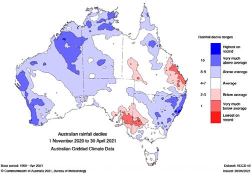
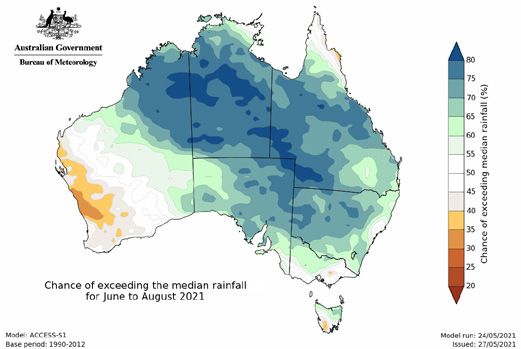
Figure 2:   RAINFALL DECILES NOVEMBER 2020 TO APRIL 2021.                            Figure 3:   CHANCE OF EXCEEDING THE MEDIAN RAINFALL FOR JUNE TO AUGUST 2021.

    RECENT CONDITIONS                                          York Peninsula, as the weather patterns               CLIMATE OUTLOOK
    Seasonal fire conditions are a function of                 were less favourable for rain further south.          The Bureau of Meteorology’s climate
    fuel (vegetation) amount and dryness, and                      The long-term warming trend means                 outlooks are based on the physics of
    recent rainfall and temperatures. The past six             that above average temperatures now                   the oceans, atmosphere, land and ice.
    months from November 2020 to April 2021                    dominate most years, and recent months                They implicitly include all current climate
    (see Figure 2, above) saw above average                    have generally followed this pattern,                 drivers, including long-term trends.
    rainfall for many areas across Australia, with             despite the cooling influence of the                     The El Niño-Southern Oscillation is neutral,
    much of the north of the country seeing                    La Niña. The national average maximum                 with model forecasts suggesting that this
    increased wet season rains and increased                   and minimum temperatures were 0.55°C                  situation is likely to continue for the winter
    vegetation growth. However, there were                     and 0.63°C higher than the long-term                  months. The Indian Ocean Dipole is currently
    a few notable exceptions, with the central                 (1961–1990) averages for October to                   also neutral. Climate model outlooks suggest
    coast of Queensland and an area of south                   April, ranking 23rd and 15th warmest of               the Indian Ocean Dipole is most likely to
    east South Australia extending into western                112 years of records – much lower than                remain neutral during the first half of winter.
    Victoria and south west New South Wales                    recent periods without La Niña influence.             Two of the five models indicate negative
    all experiencing below average rainfall for                    While the above average rainfall and              Indian Ocean Dipole thresholds may be
    the six-month period. May to date (26 May)                 relatively cooler weather have eased fire             reached during winter or spring. The accuracy
    has seen above average rainfall in parts of                risk for some areas, this has also meant              of Indian Ocean Dipole forecasts made
    south west Western Australia and eastern                   increased vegetation growth across the                during autumn is generally lower than at
    Victoria into south eastern New South Wales.               north. Additionally, the central coast of             other times of the year, but improves in
      Australia’s recent climate has been                      Queensland and south east South Australia,            winter. A negative Indian Ocean Dipole
    affected by La Niña, which developed during                extending into north west Victoria and                increases the chances of above average
    September 2020 and decayed in March                        south west New South Wales have all largely           winter–spring rainfall for much of southern
    2021. La Niña events typically increase the                missed out on the above average falls,                Australia. Above average Indian Ocean sea
    likelihood of above average rainfall across                with below average to very much below                 surface temperature patterns outside of
    much of Australia during spring, and across                average rainfall for these areas. This may            the Indian Ocean Dipole region may also
    much of eastern Australia during summer                    require further attention in coming months,           be providing conditions more conducive
    and early autumn. The 2020/21 La Niña                      should rainfall deficiencies persist.                 for rainfall across some parts of Australia.
    did indeed help deliver northern Australia’s                   The tendency for fire seasons to have                The rainfall outlook for June to August
    wettest wet season (October to April) since                elevated fire dangers more frequently, and for        (see Figure 3, above) shows that a wetter
    2016/17, and nationally it was the coolest                 elevated fire danger to occur earlier and later       than average winter is likely for most of
    such period since the La Niña of 2011/12.                  in the season is a clear trend in Australia’s         Australia except western and southern
    North west Western Australia was affected                  climate. This reflects rising temperatures            Western Australia, the Cape York Peninsula
    by several tropical lows, with one bringing                and reduced and/or less reliable cool season          and parts of south east Australia, where
    heavy rains in the Kimberley and east Pilbara              (April to October) rainfall in southern parts of      there are roughly equal chances of a
    areas in January. Another resulted in parts                the country. Fire season length and severity          wetter or drier than average winter. Some
    of the western Gascoyne having its wettest                 is increasing across much of Australia, as            western parts of Western Australia are likely
    February on record, along with extensive                   measured by annual (July to June) indices of          to have a drier winter. Historical outlook
    flooding. During March, moderate to heavy                  the Forest Fire Danger Index, with increases          accuracy for June to August is moderate
    rainfall across the Kimberley extending into               tending to be greatest across inland eastern          to high across much of Australia, but
    western and southern Northern Territory                    Australia and coastal Western Australia.              generally moderate to low around the Gulf
    also brought flooding to the region. In the                For more details on the changes observed,             of Carpentaria and south east Australia.
    east, rainfall in Queensland was largely                   see the State of the Climate 2020 report                 Average maximum temperatures for
    restricted to northern areas and the Cape                  from the Bureau of Meteorology and CSIRO.             winter are likely to be above average for

2
Figure 4:  CHANCE OF EXCEEDING THE MEDIAN MAXIMUM                                Figure 5: CHANCE OF EXCEEDING THE MEDIAN MINIMUM
   TEMPERATURE FOR JUNE TO AUGUST 2021.                                             TEMPERATURE FOR JUNE TO AUGUST 2021.

the northern tropics, south west Western               above average root zone soil moisture in               Further south, the greater Katherine
Australia, south east South Australia, east            many areas, particularly the Jarrah Forest and      region, extending down to Newcastle
coastal Queensland, eastern and southern               Warren, and parts of the Avon Wheatbelt,            Waters along the Stuart Highway, are watch
New South Wales, Victoria, and Tasmania                Mallee and Esperance bioregions, alleviating        points for fire activity. The same applies
(see Figure 4, above). Average minimum                 stress in live woody vegetation and providing       to the southern extent of the Gulf Fall
temperatures for the same period are very              good conditions for planned burning                 Uplands bioregion, east of the Tablelands
likely to be above the long-term average               activities. In contrast, the Nullarbor, Hampton     Highway. In central Australia, there is
across most of Australia (see Figure 5,                and part of Great Victoria Desert bioregions        ongoing opportunity for prescribed burning
above). Historical accuracy for winter                 remain dry. However, with average rainfall          over the coming months, with normal fire
maximum temperature outlooks is high                   predicted for early winter, fire potential in       potential assessed in these regions.
to very high across the northern tropics               these areas is also expected to be normal.
and the southern half of the country.                                                                      QUEENSLAND
Elsewhere, accuracy is low. Historical                 NORTHERN TERRITORY                                  Most of Queensland has experienced mild
minimum temperature outlook accuracy is                The Northern Territory, which has just come         and wet conditions for the first six months
moderate to high across most of Australia,             out of its wet season, has experienced above        of 2021. This will likely see long-term rainfall
but moderate to low across south east                  average rainfall in the past six months. The        deficits reduced through most of the state,
and south west Australia. The long-term                area spanning from the top of the Victoria          except coastal and inland areas between
warming trend continues to provide a                   Bonaparte through to the Daly Basin, as             Rockhamption and the Wide Bay area, leading
background influence on outlooks.                      well as areas of the Gulf Uplands to Pine           into the winter period. The outlook for rainfall
  Updates to climate forecasts, including              Creek bioregions, has received the highest          for winter is average for the far north and
forecasts of monthly, fortnightly and weekly           rainfall on record. The wetter than average         Cape York Peninsula areas and above average
outlooks and the outlook for the Indian                season has left widespread vegetation (fuel)        across the remainder of the state. These
Ocean Dipole and the El Niño–Southern                  growth with steadily increasing grass curing.       conditions have resulted in an assessment
Oscillation will continue to be published                The El Niño-Southern Oscillation is now           of normal fire potential for the entire state.
at www.bom.gov.au/climate/ahead.                       neutral and the dry season has settled                 With the El Niño–Southern Oscillation
                                                       in, making current conditions favourable            neutral and expected to remain inactive for
REGIONAL SUMMARIES                                     for planned burning. Since late April,              winter, Queensland’s climate is expected
                                                       land managers have been utilising this              to be influenced by local drivers. The
WESTERN AUSTRALIA                                      opportunity, with aerial and ground burning         temperature outlook shows average
In northern Western Australia, with the                operations well underway across the Top             maximum temperatures in the central to
exception of Dampierland and part of                   End. However, some areas, particularly              south west inland areas, with above average
the Great Sandy Desert, most bioregions                around the Darwin Coastal bioregion, are            temperatures across the remainder of the
have continued to receive above average                expected to retain root zone soil moisture          state. Increased minimum temperatures
rainfall. This is reflected in the current             over the early dry season (May and June).           are forecast for the entire state.
high root zone moisture content, as well               With challenges to mitigate fuel in the peri-          The observed weather conditions,
as relatively low grass curing levels across           urban interface, fire potential is expected to      together with the indication of milder
the landscape for this time of year. The               be above normal during the late dry season          conditions and the increased chances
preceding weather conditions and later                 (July to October) in the eastern reaches of         of above average rainfall in many areas,
than average grass curing have resulted in             the Pine Creek region and central Darwin            indicate a slower start to the fire season.
normal fire potential for northern regions             Coastal bioregions. This area encompasses           Conditions will be favourable for continued
of the state for this outlook period.                  the Northern Fire Protection Zone, including        grass growth, increasing the fuel loads in
  Several ex-tropical systems and strong               the Darwin, Batchelor, Adelaide River and           grassland areas. The potential for frosts
early season cold fronts have resulted in              Pine Creek Emergency Response Areas.                in the south western inland areas in the

                                                                                                                                                              3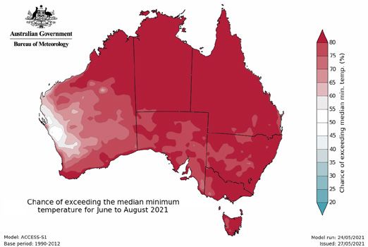
coming months may lead to localised                  ACT                                                     Planned burning may be able to
    curing of grassland and the possibility of           Winter conditions are expected to bring               continue in some drier forest types in
    high intensity grass fires during the fire           near average rainfall for the ACT, due to             the north and west of the state. District
    season. Underlying drought conditions                the neutral El Niño–Southern Oscillation              staff and planned burn teams will monitor
    may generate an early onset of grass                 conditions (neither El Niño nor La Niña),             fuel conditions to conduct planned burn
    fires in the South Burnett region in June,           along with most other climate drivers                 operations safely and effectively.
    progressing into the western area between            being neutral. Above average minimum
    Maryborough and Gympie into early July.              and maximum temperatures are also                     SOUTH AUSTRALIA
                                                         forecast, resulting in normal fire potential          Much of South Australia remains drier
    NEW SOUTH WALES                                      in all areas throughout winter.                       than average, without any significant rain
    Leading into winter, long-term rainfall                Neutral climate conditions will allow               occurring in the last few months across
    deficits have been reduced across most               fire agencies and land managers to                    most agricultural and southern areas. This
    of NSW, with autumn being wetter than                continue prescribed burning over the                  has resulted in parts of the state recording
    average for much of the state. As a result           coming months when conditions allow.                  rainfall deciles that are very much below
    of preceding conditions, subsequent fuel               The rainfall received in May means that             average. However, the current winter
    state and the climate outlook, normal fire           grassland areas are likely to allow for               outlook indicates the potential for above
    potential has been assessed for winter.              prescribed burning sooner than forest                 average rainfall, which may help reduce
    Previous seasons’ conditions, as well as             areas. Residents in the ACT can monitor               the existing short-term soil moisture
    rainfall and temperature outlooks for winter,        planned prescribed burns through either               deficits ahead of the next fire season.
    are important early indicators for the start of      the ACT Emergency Services Agency                     This increased likelihood of exceeding
    the upcoming fire season and its potential.          and ACT Parks and Conservation Service                the average winter rainfall across South
      With neutral El Niño–Southern Oscillation          websites, or through the Fires Near Me app.           Australia means that normal fire potential
    conditions and an inactive El Niño–Southern                                                                is expected across the state over the
    Oscillation outlook forecast, the climate            VICTORIA                                              coming months. However, if South Australia
    outlook for winter in NSW is likely to be            Autumn rainfall was varied across Victoria,           does not receive good winter rainfall, the
    more influenced by local drivers. The                with March and May seeing wetter                      chances of bushfires during the 2021/22
    rainfall outlook for the coming months               conditions in central and eastern areas,              fire danger season may increase. Agencies
    suggests an increased chance of above                while April was dry. These conditions,                will continue to conduct prescribed burns
    average rainfall west of the ranges, while           combined with the already-high levels of              where conditions allow, noting that the local
    average rainfall is likely along parts of            underlying vegetation moisture, resulted              conditions through the winter period are
    the east coast. The temperature outlook              in significantly reduced levels of bushfire           typically not conducive to this occurring.
    is for increased maximum and minimum                 activity for autumn, while enabling an
    temperatures for much of the state. It is            earlier start to the planned burning season.          TASMANIA
    likely that the east coast and ranges will see       Winter will see Victoria transitioning into           The widescale renewal of soil moisture during
    above average maximum temperatures.                  a low-risk period for bushfires for this              summer has now slowed, as reflected in
      With these conditions, hazard reduction            time of year, resulting in an assessment of           the reduced Soil Dryness Index in the east
    burning may be able to continue during               normal bushfire potential across the state.           of Tasmania, with mostly average levels
    winter, particularly towards the latter half,          In the west and north, as well as the north         observed elsewhere. Recent conditions
    when weather conditions allow. West of               east foothills, soil moisture is currently            have been dry and the early winter period
    the ranges, warmer than average nights               drier than average. The climate outlook               is expected to contribute only average
    may mean less frosts. Wetter than average            suggests average or near average rainfall             rainfalls. Winter temperatures are likely to
    soil moisture through the central west,              is expected across most of the state,                 be above average, noting that there were
    combined with higher chances of above                which may contribute to a reduction of                both unusually high and low temperatures
    average rainfall, will likely result in continued    bushfire risk in Victoria next fire season.           in April. Conditions are likely to slowly dry
    favourable conditions for grass and winter           However, in parts of the east, the outlook            during the outlook period, which may allow
    crop growth. This situation would create             indicates a chance of drier conditions                an early commencement to the spring
    higher fuel levels and, in the event of fires        (below average rainfall and above average             planned burning season. As a result of these
    during the fire season, higher intensity             maximum temperatures). This will be closely           predictions, Tasmania is expecting normal
    grass and crop fires in these areas.                 monitored during the winter months.                   fire potential for the outlook period.

    The Bushfire and Natural Hazards             Hazard Notes are prepared from                All material in this document, except as identified below,
    CRC is a national research                   available research at the time of             is licensed under the Creative Commons Attribution-Non-
    centre funded by the Australian              publication to encourage discussion           Commercial 4.0 International Licence.
    Government Cooperative Research              and debate. The contents of Hazard            Material not licensed under the Creative Commons licence:
    Centre Program. It was formed in             Notes do not necessarily represent the             •   Bushfire and Natural Hazards CRC logo
    2013 for an eight-year program               views, policies, practises or positions            •   All photographs.
    to undertake end-user focused                of any of the individual agencies or          All rights are reserved in content not licenced under the
    research for Australia and                   organisations who are stakeholders of         Creative Commons licence. Permission must be sought
    New Zealand.                                 the Bushfire and Natural Hazards CRC.         from the copyright owner to use this material.

4                                                                                                                                         www.bnhcrc.com.au
You can also read