AUSTRALIAN SEASONAL BUSHFIRE OUTLOOK: SEPTEMBER - NOVEMBER 2020 - Bushfire & Natural ...
←
→
Page content transcription
If your browser does not render page correctly, please read the page content below
ISSUE 77 AUGUST 2020
TOPICS IN THIS EDITION | FIRE IMPACTS | FIRE SEVERITY | FIRE WEATHER

AUSTRALIAN SEASONAL BUSHFIRE
OUTLOOK: SEPTEMBER – NOVEMBER 2020
OVERVIEW
The 2020/21 fire season will be driven
by vastly different climate drivers than
the previous two fire seasons. With a
La Niña ALERT now active, large areas
of eastern and northern Australia are
expecting wetter than average conditions
through spring. Despite the wetter climate
signals, parts of Queensland face above
normal fire potential in the south east and
central coast, extending to the north.
   While these wetter conditions in eastern
Australia will help in the short-term, they
may lead to an increase in the risk of fast
running fires in grasslands and cropping
areas over summer. These conditions will be                 Above normal fire potential
monitored closely over the coming months.                   Normal fire potential
   In contrast to the wetter conditions                     Below normal fire potential
for the east, dry conditions persist
in Western Australia, with above
                                                    Figure 1:   AUSTRALIAN SEASONAL BUSHFIRE OUTLOOK: SEPTEMBER – NOVEMBER 2020. AREAS ARE BASED ON
normal fire potential continuing to be              THE INTERIM BIOGEOGRAPHIC REGIONALISATION FOR AUSTRALIA AND OTHER GEOGRAPHICAL FEATURES.

expected in parts of the north.
  The Australian Seasonal Bushfire Outlook:      OUTLOOK – SPRING 2020                                      DEFINITION
September - November 2020 covers                 Fire management is a year-round process,                   Fire potential: The chance of a fire
all states and territories. It reflects the      and bushfire potential depends on many                     or number of fires occurring of such
priorities in each state and territory for the   factors. The volume, location and timing                   size, complexity or other impact (such
coming months given the expected climate         of rainfall are critically important when                  as biodiversity or global emissions)
conditions, and provides information to          estimating vegetation (fuel) volumes and                   that requires resources (from both
assist fire authorities in making strategic      growth. The climate outlook for the next few               a pre-emptive management and
decisions such as resource planning and          months is also a crucial factor. Of particular             suppression capability) beyond the
prescribed fire management to reduce             interest are the future tendencies of Pacific              area in which it or they originate.
the negative impacts of bushfire.                sea surface temperature associated with the                Fire potential depends on many
  The Australian Seasonal Bushfire Outlook:      El Niño-Southern Oscillation, as well as the               factors including weather and climate,
September - November 2020 is developed           Indian Ocean Dipole, major climate drivers                 fuel abundance and availability,
by the Bushfire and Natural Hazards              over Australia. Other less quantifiable factors,           recent fire history and firefighting
CRC, AFAC, the Bureau of Meteorology,            such as the distribution and readiness of                  resources available in an area.
Queensland Fire and Emergency Services,          firefighting resources, are also considered.
the New South Wales Rural Fire Service, ACT        Both the El Niño-Southern Oscillation
Emergency Services Agency, ACT Parks and         and the Indian Ocean Dipole are expected                Dipole may develop during spring, which
Conservation Service, Country Fire Authority,    to influence the weather, and therefore fire            would further increase the likelihood of
Department of Environment, Land, Water           conditions, during spring. In the Pacific,              wetter conditions in eastern Australia.
and Planning Victoria, Tasmania Fire Service,    a La Niña ALERT was issued in mid-August                  Across the country, autumn and winter
Country Fire Service, Department of Fire         by the Bureau of Meteorology. La Niña                   presented opportunities to conduct prescribed
and Emergency Services and Department of         typically sees above average spring and                 burning where appropriate weather conditions
Biodiversity, Conservation and Attractions       summer rainfall over much of eastern and                allowed. In some states and territories, this
Western Australia, and Bushfires NT.             northern Australia. A negative Indian Ocean             will continue through spring when possible.

              | All Hazard Notes are available at www.bnhcrc.com.au/hazardnotes                                                                          1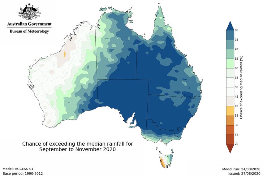
raised to La Niña WATCH in late June, then
to La Niña ALERT in mid-August. This means
there is now around a 70% chance of La Niña
forming in 2020, roughly triple the normal
likelihood. La Niña typically sees above
average spring and summer rainfall over
much of eastern and northern Australia.
Combined with warmer than average waters
in the eastern Indian Ocean, this is helping
to increase the likelihood of wetter than
average conditions across the eastern two-
thirds of Australia in the coming months.
Furthermore, half of the models surveyed
by the Bureau indicate a negative Indian
Ocean Dipole may develop during spring.
Figure 2: RAINFALL DECILES 1 MARCH TO 28 AUGUST.
A negative Indian Ocean Dipole would act to
further increase the likelihood of wetter than
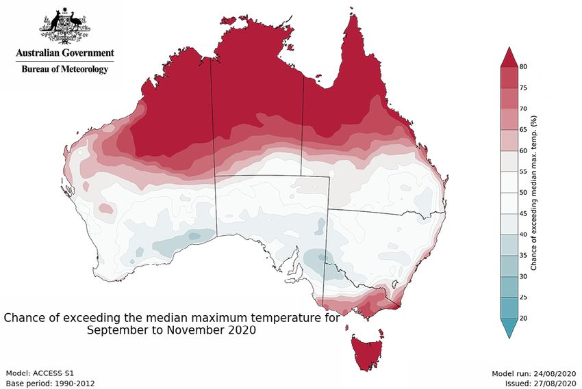
RECENT CONDITIONS The long-term warming trend means that average conditions across eastern Australia.
Seasonal fire conditions are a function of above average temperatures now occur in The rainfall outlook for September to
fuel (vegetation) amount and state, and most years, and recent months have followed November (Figure 3, page 3) shows wetter
seasonal weather conditions. 2019 was this pattern. The exception to this was than average conditions are very likely for
warmest and driest year on record for May 2020, which saw the first cooler than most of the eastern two-thirds of mainland
Australia, with many records set. To date, average month nationally since October 2016. Australia, while conditions are likely to be
2020 has seen a shift away from these Temperatures in Australia for 2019 were the drier than average around the Kimberley
drier conditions to closer to average rainfall warmest in 110 years of record (+1.52°C above and Pilbara regions of Western Australia, as
patterns for large parts of the country. the 1961–1990 average, see Annual Climate well as south western Tasmania. Most of the
However, the last six months has seen Statement 2019, Bureau of Meteorology). remainder of the country has roughly equal
drier than average conditions over central To date, 2020 has continued to bring chances of wetter or drier than average
and south east Queensland and parts of warmer than average conditions for conditions. Historical outlook accuracy
southern Australia, including large parts of much of the north and west of Australia. for September to November is very high
Western Australia (see Figure 2, above). Western Australia recorded its second across much of Australia, but generally
Rainfall deficiencies over large parts of warmest July on record in 2020, second moderate to low around the Western
drought affected New South Wales and only to July 2019, while June 2020 was Australia and Northern Territory border.
Victoria have reduced significantly compared warmest on record. High temperatures Maximum temperatures during September
to this time last year, and soil moisture add to the impact of reduced rainfall to November are very likely to be warmer
has returned to average in many areas. by increasing evaporation. Cooler than than average across the northern tropics
However, multiple years of below average average conditions have been experienced and most of Tasmania, while cooler than
rainfall means that much of the northern around large parts of the south east away average conditions are likely over most
Murray–Darling Basin, eastern South Australia from mainland eastern coastal areas. of New South Wales and South Australia,
and south west Western Australia require The combined very hot and dry conditions southern Queensland, northern Victoria and
a much longer period of above average of 2019 saw Australia experience one of the south east coast of Western Australia
rainfall for the wider environment to fully its most devasting southern fire seasons (Figure 4, page 3). Elsewhere, temperatures
recover. For instance, while water levels in in 2019/20. Rainfall so far in 2020 has are closer to average. Minimum temperatures
storages across the northern Murray Darling eased the fire risk for large parts of eastern (not shown) are very likely to be warmer
Basin have increased in recent months, Australia, however southern South Australia than average across the eastern two-
they remain at only 21% of their capacity. and Western Australia have seen drier and thirds of Australia, while the outlook is for
Despite above average rainfall across large warmer conditions persist this year. More closer to average temperatures towards
parts of the country since the start of the rainfall is needed across many areas to fully south western Western Australia. Historical
year, June and July were largely drier than recover from the extreme season of 2019/20. accuracy for September to November
average nationally, especially in the south maximum temperatures is high across all of
west. In contrast, some regions such as CLIMATE OUTLOOK Australia. Minimum temperature accuracy is
the south coast of New South Wales have Climate outlooks are influenced by current moderate to high across much of Australia,
recorded above average rainfall, largely climate drivers, together with other very high in Victoria and Tasmania, and
from the impact of multiple coastal lows. factors including long-term trends. low around central parts of Queensland.
South west and southern Western Australia The climate influences in 2020 are very The tropical cyclone season, which
is notable in that it has seen much drier different to those that led to the extreme dry typically starts in November, is likely to be
than average conditions in autumn and conditions in 2019. Both the El Niño–Southern more active this season than in recent years
winter – normally the wettest time of year Oscillation (ENSO) and the Indian Ocean for both Queensland and Western Australia
for these regions. These regions have seen Dipole are currently neutral. However, the due to the influence of La Niña. While this
an increase in the area in drought this winter. Bureau of Meteorology’s ENSO Outlook was may increase the chance of rainfall, areas
2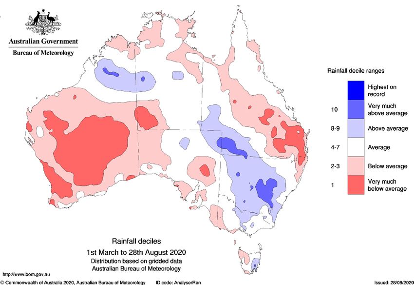
Figure 3:  CHANCE OF EXCEEDING THE MEDIAN RAINFALL                                 Figure 4:  CHANCE OF EXCEEDING THE MEDIAN MAXIMUM
   FOR SEPTEMBER TO NOVEMBER 2020.                                                    TEMPERATURE FOR SEPTEMBER TO NOVEMBER 2020.

of increased wind could potentially interact            around 60% of the state comprising grass             ACT
with any fires in the south of the country.             and woodland with grassy understory fuels,           In early August the ACT received sufficient
  Updates to climate forecasts, including               normal fire potential has been assessed.             rainfall to remove the residual drought that
forecasts of monthly, fortnightly and weekly                                                                 was posing a raised forest fire threat for
outlooks and the outlook for the Indian                 NEW SOUTH WALES                                      the coming fire season. As a result of this
Ocean Dipole and the El Niño–Southern                   Large parts of NSW have experienced                  rain, and the expectation of further rainfall
Oscillation will continue to be published               welcome rain over the last six months,               in spring with a La Niña ALERT current, it
at www.bom.gov.au/climate/ahead.                        reducing soil moisture deficits for much             is anticipated that forest flammability will
                                                        of the state. However, long-term rainfall            remain low over the coming months. The
REGIONAL SUMMARIES                                      deficiencies are still significant in the north      effect of the rains on grass fire risk may not
                                                        and west. In particular, dry sub soil conditions     become clear until the end of spring or early
QUEENSLAND                                              on the northern ranges are of concern.               summer. These conditions will be monitored
The major climate drivers are favouring a               These areas are being monitored closely.             over the coming months. For the outlook
wetter than normal spring across most of                  With a La Niña ALERT current, the rainfall         period, normal fire conditions are expected.
Queensland. If this rainfall eventuates there is        outlook appears favourable for much of the              The ACT Emergency Services Agency
potential for the bushfire season to be milder          state. Whilst the bushfire outlook on the            (ESA) advises that rural residents, and those
than the previous two seasons. However, if              balance of the forecast is normal for NSW for        on the urban edge of Canberra, need to
widespread rain does not eventuate, above               the outlook period, there is a need to monitor       review their bushfire preparedness plans
normal bushfire potential in forested areas             for escalation to fire danger associated with        and prepare their property with a focus
in South East Queensland and some central               windy weather events that can often present          on potential impacts from fast moving
coast areas extending north is likely.                  during this period. These windy conditions           grass fires over summer. Further advice
  The South East, bounded by Rockhampton                can be a risk regardless of the temperature          will be provided to the community by ESA
to the NSW border south of Cunnumulla, and              where grass has been cured by frosts.                as the spring grass growth concludes.
extending to the coast, has seen significantly            The grass fire risk will continue to be            Government agencies will continue to
below average rainfall over the past 12 to              monitored on and west of the Divide over             implement plans to mitigate grass fire risks.
24 months. As a result, most of this area is            coming months. Recent and forecast
experiencing significant drought. Twelve-               rain, combined with warmer than average              VICTORIA
month rainfall deficiencies have also persisted         minimum temperatures, may provide                    The above average rainfall experienced
along much of the state’s east coast.                   ideal growing conditions for cropping and            during winter has substantially reduced the
  August has seen above average rainfall                grassland areas. This spring growth has              risk of campaign bushfires in Victoria’s east
in some coastal areas between Mackay                    the potential to increase grass and crop             for the outlook period. Elsewhere, much
and Cairns, and from Maryborough to                     fuel loads as it dries through summer,               of Victoria has experienced average to
the NSW border. However significant                     and this will be monitored closely.                  below average rainfall during winter. Parts
rainfall is still needed to return these                  Higher grass fuel loads can increase               of the Mallee, Wimmera and Far South
areas to average conditions.                            fire danger by increasing the intensity              West are drier than normal, however the
  Across the remainder of the state very                of grass fires. All other factors being              current climatic signals indicate that there
large areas have very low to no grass cover             equal, this increase of the intensity                is a high chance of above median rainfall
relative to long-term records. With a La                makes the grass fires hotter, more                   across Victoria during spring. The strength
Niña ALERT current, Queensland is likely to             dangerous and harder to extinguish.                  of this signal is higher north of the Divide
experience above median rainfall during the               Where weather permits, NSW fire                    compared to the south of the Divide.
outlook period. As a result it is very unlikely         and land management agencies will                       As a result, greater uncertainty exists for
this will translate into an elevated grass              continue to undertake hazard reduction               the bushfire outlook in western Victoria.
fire risk before December. Therefore, with              activities in the coming months.                     It is possible that occurrences of hot,

                                                                                                                                                              3
dry periods may be enough to offset the increased rain for southern South Australia leading to an assessment of normal
wetter signal associated with possible than for the east coast. A number of variables fire potential for the outlook period.
La Niña conditions during spring. have to line up for these wetter conditions to In contrast, some areas in northern WA
Overall, the influence of a possible La Niña occur in southern South Australia. Increased are experiencing higher moisture content
is expected to reduce the risk of prolonged rainfall for the state is more often influenced in the root zone in comparison to this time
fire activity across most of Victoria, leading by a negative Indian Ocean Dipole, and while last year, and this is reflected in the lower
to an assessment of normal fire potential climate models indicate this may occur, the seasonal grassland curing for some areas
for the outlook period for the entire state. signals would only support wetter conditions of the Kimberley and Pilbara regions. These
Short duration fires in grasslands and for a brief period in early spring, rather than conditions have delayed the onset of the
drier forests/woodlands are still likely to an indication of prolonged wetter conditions. northern WA bushfire season. For the start
occur by late spring, depending on fire Spring rainfall could also encourage grass of the late dry season, higher than normal
weather conditions and grassland curing. growth which may raise fuel loads in fuel loads continue to persist for parts
areas where they are currently reduced. of the Dampierland, Central Kimberley
TASMANIA The current rainfall outlook is unlikely to and Ord Victoria bioregions, resulting in
After a dry start to winter, the eastern overcome the current soil dryness and long- a continued assessment of above normal
half of Tasmania now has high moisture term rainfall deficiencies. The Fire Danger fire potential for these areas as per July’s
levels and the Soil Dryness Index is close Season may start later than the previous two Australian Seasonal Bushfire Outlook.
to zero. Follow up rains during spring will seasons, however any benefits from spring
provide valuable moisture recharge for rain will quickly be marginalised once warmer NORTHERN TERRITORY
lower soil levels and increased fuel moisture weather occurs. In addition, spring rainfall Wet season rainfall totals in most areas
in coarse and heavy fuels. Forested areas is often accompanied by thunderstorm across the Northern Territory were well
are very wet and will take time to become activity which could see an increase in below average for 2019/20, and as a result
available as fuel. It is anticipated that the lightning and new ignitions occurring. many areas are now experiencing drier soil
start of the fire season will be delayed on Western South Australia (including much moisture and earlier vegetation curing. As
the east coast and in the south east. of the Eyre Peninsula), the Flinders Ranges, noted in the Australian Seasonal Bushfire
During spring pasture growth is and the Riverland are currently experiencing Outlook: July 2020, the Fire Danger Period
likely to be significant in the Midlands, drought-like conditions which is likely to for the northern half of the Territory was
South East and East Coast districts. limit grass and crop growth. These regions declared earlier than normal. In some areas
These areas have been assessed as will be monitored closely, especially in of the savanna region, vegetative fuel
normal fire potential for the outlook areas of native vegetation and scrub, which loads remain lower than average. Planned
period, but will be monitored closely. could present challenges later. Without burning in the north was predominately
The western half of Tasmania has closer good rainfall during spring, this pattern limited to strategic corridors, carbon burning
to normal moisture conditions for winter. of potentially reduced grass fire risk and projects, and fine scale properties. For the
With a La Niña ALERT current, the far elevated scrub and forest fire risk is likely to top half of the Territory, the duration and
south west may become significantly persist over much of the state come summer. extent of the fire weather to date has been
drier than normal, which can occur during slightly less than what was experienced
a La Niña. This area will be monitored WESTERN AUSTRALIA in the 2019 fire season, with the western
closely and has been assessed as normal The climate outlook indicates normal Top End experiencing higher than average
fire potential for the outlook period. weather conditions for Western Australia humidity during August. The Bureau of
from August through October, with the Meteorology’s weather modelling indicates
SOUTH AUSTRALIA possibility of below-normal rainfall in parts a negative Indian Ocean Dipole is possible
South Australia has experienced the third of the South West Land Division. Seasonal in coming months. This may increase the
driest June and July on record, and as a rainfall deficiencies have continued, chances of an early onset to the wet season
result prolonged moisture deficits persist. which is preventing the recovery of root and the possibility of exceeding October
While the La Niña ALERT that is now zone soil moisture in much of the eastern and November median rainfall. A review of
active indicates that the forecast models Wheatbelt and the eastern South Coast fire season activity to date, completed fire
favour wetter than average conditions for and leading to persistent moisture stress in mitigation and overall fuel loads indicates
spring across South Australia, historically woody vegetation. Despite overall below normal fire potential for all regions of
La Niña has had less of an impact on normal rainfall, recent rain has helped, the Territory for the outlook period.
The Bushfire and Natural Hazards Hazard Notes are prepared from All material in this document, except as identified below,
CRC is a national research available research at the time of is licensed under the Creative Commons Attribution-Non-
centre funded by the Australian publication to encourage discussion Commercial 4.0 International Licence.
Government Cooperative Research and debate. The contents of Hazard Material not licensed under the Creative Commons licence:
Centre Program. It was formed in Notes do not necessarily represent the • Bushfire and Natural Hazards CRC logo
2013 for an eight-year program views, policies, practises or positions • All photographs.
to undertake end-user focused of any of the individual agencies or All rights are reserved in content not licenced under the
research for Australia and organisations who are stakeholders of Creative Commons licence. Permission must be sought
New Zealand. the Bushfire and Natural Hazards CRC. from the copyright owner to use this material.
4 www.bnhcrc.com.auYou can also read