PHOSPHORUS MITIGATION PLAN - Woldwide 1 & 2 - Environment Southland
←
→
Page content transcription
If your browser does not render page correctly, please read the page content below
Woldwide 1 & 2

PHOSPHORUS
MITIGATION
PLAN
Woldwide 1 & 2

ABOUT YOUR FARM
PLAN

This Farm Plan document is the result of a tailored farm environment planning service provided to
you through Tiaki Sustainable Dairying. It’s part of the advantage you get through Farm Source as a
member of the Fonterra Co-Operative. The purpose of this plan is to describe the environmental
conditions present on your farm and the management of these conditions. From this, mitigations to
potential impacts to water quality are documented and additional mitigations maybe planned, with
sensible timeframes. Underpinning this plan, are the agreed national Good Farming Practices that
are supported by the agricultural and horticultural sectors. Industry bodies along with Regional
Councils and Central Government have developed the Good Farming Practice: Action Plan for
Water Quality 2018 in a commitment to swimmable rivers and improving the ecological health of
our waterways. The Dairy Industry Strategy (Dairy Tomorrow), as well as the Good Farming
Practice: Action Plan for Water Quality 2018, both align with the goal for all dairy farms to have a
Farm Environment Plan by 2025. Now that this plan has been created it’s the plan owner’s
responsibility to ensure it is put into action and kept up to date as actions are completed or
conditions on farm change. Tiaki Sustainable Dairying is here to help with that implementation and
ongoing management through our team of Sustainable Dairying Advisors who can be contacted via
the details below.

PHONE: 0800 65 65 68

EMAIL: sustainable.dairying@fonterra.com

 CONTENTS:
 FARM DETAILS ................................................................................................................... 3
 FARM OVERVIEW MAP ..................................................................................................... 5
 SUMMARY OF OPEN ACTIONS ....................................................................................... 6
 UNDERSTANDING THE RISKS ON YOUR FARM .......................................................... 7
 RISK RATING ....................................................................................................................... 8
 PHOSPHORUS MANAGEMENT ................................................................................................ 9

                                                                                                                                          2
Woldwide 1 & 2

FARM DETAILS
FARM NAME
                        Woldwide 1 & 2
SUPPLIER NUMBER         32650 & 32651

PLAN OWNER              Albert De Wolde
                        +64 27 2272537
                        dewolde@farmside.co.nz

FARM ADDRESS
                        HUNDRED LINE RD, Winton

LOCATION

REGIONAL COUNCIL
                        Southland
PLAN LAST EDITED DATE   31 July 2019

POINTS OF NOTE

                                                                  3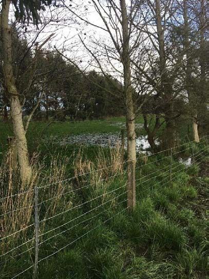
Woldwide 1 & 2

FARM OVERVIEW MAP
The map below presents the land on which the farming operations covered in this document occur and
identifies some key points of interest. More detailed maps looking at specific environmental
management topics are contained throughout the document.

      Accord Defined Stock Excluded Waterway             Compliant Crossing

      Accord Defined Stock Not Excluded Waterway         Non-Compliant Crossing

      Non-Accord Defined Stock Excluded Waterway         Non-Compliant Non-Regular Crossing

      Non-Accord Defined Stock Not Excluded Waterway     Dispensation Crossing

      Farm Boundary                                      Dairy Shed

                                                                                                          4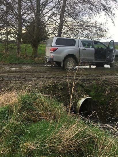
Woldwide 1 & 2

           SUMMARY OF OPEN ACTIONS
           This table includes all open or ongoing actions that have been agreed as part of this Farm
           Environment Plan. They are organized by their target due date. Where an action has been identified
           as especially important an additional (Flag) icon may have been added.

CATEGORY       FEATURE TYPE & NAME                                         ACTION REQUIRED                                       TARGET DATE

               Race Maintenance & Management - Lane Adjacent
     L2
                                                                           Establish Vegetated Riparian Margin (Beside Barn)     1st August 2020
               Waterway (West of Wintering Barn)

               Critical Source Area - Critical Source Area (Paddocks 14-
     L3                                                                    Increase riparian buffer (triangle paddock)           1st August 2020
               15)

               Critical Source Area - Critical Source Area (Paddocks 14-
     L3
                                                                           Enlarge Culvert (Paddocks 14-15)                      1st August 2020
               15)

               Race Maintenance & Management - Central Lane
     L4                                                                    Reduction in Use of Central Dairy Lane                New Consent
               (between WOL and WTL)

               Race Maintenance & Management - Central Lane
     L4
                                                                           Slope Lane and Extend Riparian Buffer-Central Lane    1st August 2020
               (between WOL and WTL)

               Race Maintenance & Management - Lane Beside
     L5                                                                    Extend Riparian Margin & Slope Lane                   1st February 2021
               Waterway (Paddocks 18 & 19)

     L6        Culvert Management                                          Build up sides of culvert (South of Paddock 34)       1st February 2021

               Critical Source Area - Main Culvert (South of Wintering
     L7                                                                    Install Kerb - Main Culvert South Wintering Barn      1st February 2021
               Barn)

     L8        Overland Flow Path - Overland Flow Path (Paddock 15)        Move Temporary Lane (Paddock 15)                      1st February 2021

               Overland Flow Path - Critical Source Area (Paddock
     L9                                                                    Extend Riparian Margin (Marcel #1)                    1st February 2021
               Marcel #1)

               Race Maintenance & Management - Lane Adjacent
     L10
                                                                           Modify Lane beside Creek (Paddock 34)                 1st February 2021
               Waterway (Paddock 34)

     L11       Overland Flow Path - Overland Flow Path (Paddock 34)        Extend Riparian Margin (Paddock 34)                   1st August 2021

               Critical Source Area - Culvert - Woldwide Two Dairy
     L12
                                                                           Build up Culvert Sides (Beside WTL Dairy Shed)        1st August 2021
               Shed

     L13       Critical Source Area - Culvert (Paddock Marcel#9)           Raise sides of culvert (Marcel #9)                    1st August 2021

     L14       Overland Flow Path - Critical Source Area (Paddock 21)      Extend Riparian Buffer (Paddock 21)                   1st August 2021

                                                                                                                                                     5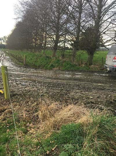
Woldwide 1 & 2

  UNDERSTANDING THE RISKS
  ON YOUR FARM
  This section provides some context to help understand the relative impact and likelihood of
  environmental risks that have been identified on your farm. The chart on this page together with the
  map on the following page can be useful when thinking about what environmental risk areas on your
  farm need the most focus.

                                                      L10 L5 L6
                                      L12                                L2 L3 L4
                                                      L7 L8 L9

                                   L11 L13                L14

HOW ARE RISK RATINGS MEASURED?
The issues plotted on the chart above have been done so based upon two measures that are assigned to a specific area of your
farm where an environmental risk has been identified. 1. Impact of contamination (on the vertical axis, or the first dial) is a measure
of the potential scale or significance of contaminants that may be lost from this area of your farm. It’s about quantifying how bad
could the outcome for the environment be; 2. Likelihood of contamination (on the horizontal axis, or the second dial) is about the
chance of the contamination actually occurring from that area of your farm. It takes into account things like how far the area might
be from waterways as well as the slope or aspect of the area; When combined together the two measures also give an overall ‘risk
rating’. The measures and the combined rating are presented for each risk area along with other descriptive information about the
risk area on the subsequent pages of this document.

Example:

                                                                                                                                          6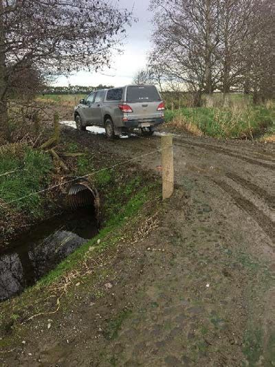
Woldwide 1 & 2
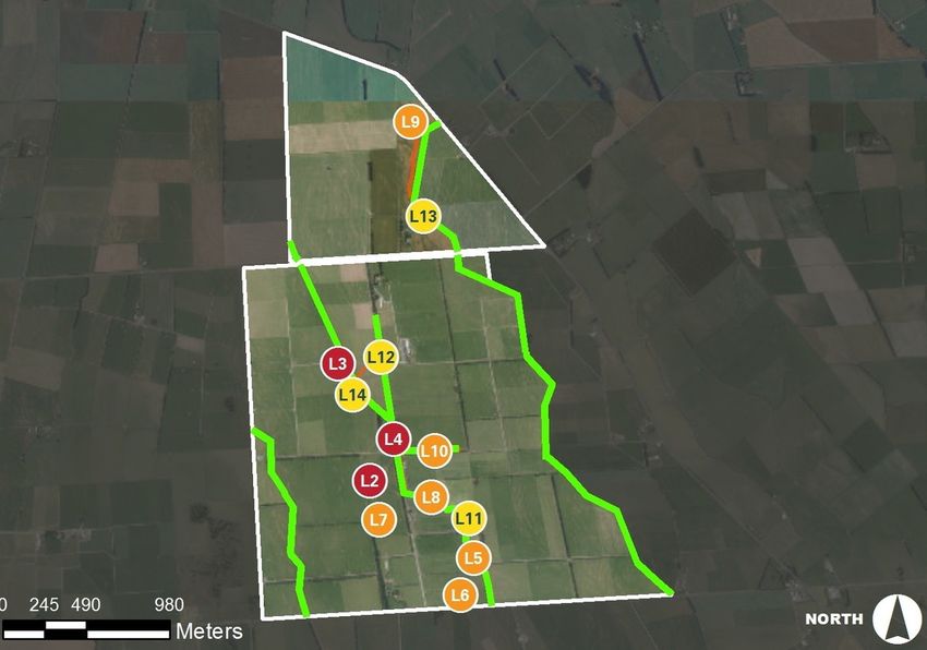
RISK RATING
The map below shows the location of the risk areas identified on your farm. The Risk Rating
presented here is a combined measure of the impact and likelihood of contamination occurring from
each risk area.
LOW MEDIUM HIGH SEVERE
L2 Race Maintenance & Management - Lane L6 Culvert Management
Adjacent Waterway (West of Wintering Barn)
L7 Critical Source Area - Main Culvert (South of
L3 Critical Source Area - Critical Source Area Wintering Barn)
(Paddocks 14-15)
L8 Overland Flow Path - Overland Flow Path
L4 Race Maintenance & Management - Central Lane (Paddock 15)
(between WOL and WTL)
L9 Overland Flow Path - Critical Source Area
L5 Race Maintenance & Management - Lane beside (Paddock Marcel #1)
Waterway (Paddocks 18 & 19)
7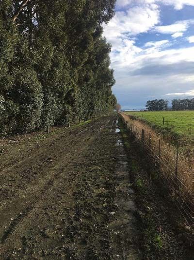
Woldwide 1 & 2

L10   Race Maintenance & Management - Lane
      Adjacent Waterway (Paddock 34)
                                                      L13   Critical Source Area - Culvert (Paddock Marcel#9)
L11   Overland Flow Path - Overland Flow Path
      (Paddock 34)
                                                      L14   Overland Flow Path - Critical Source Area
                                                            (Paddock 21)
L12   Critical Source Area - Culvert - Woldwide Two
      Dairy Shed

                                                                                                           8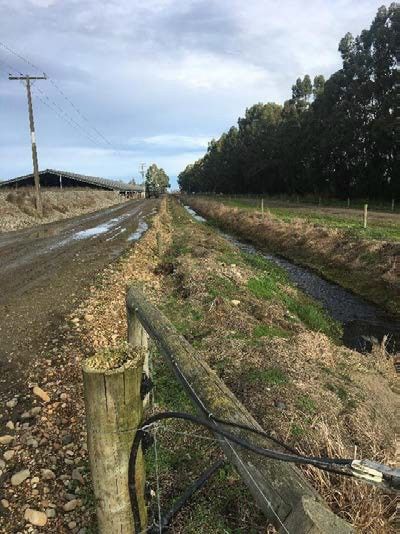
Woldwide 1 & 2

    LAND MANAGEMENT

  L1
           Phosphorus Loss Overview

DESCRIPTION:
The overall property comprised of Woldwide One and Woldwide Two (as proposed) has three waterways passing
through it and two tributaries to these waterways. The topography of the farm is flat, resulting in very few critical
source areas that would facilitate the overland flow of contaminants into adjacent waterways. The main areas
likely to be responsible for phosphorus losses are laneways that run adjacent to waterways and waterway
crossing points (culverts).

Overseer is not spatially explicit and is unable to take into account landscape features. It assumes a hydrological
connection exists to second order streams and that there is a transport mechanism to get phosphorus to those
streams. The model will over estimate phosphorus loss if a significant portion of the block is hydrologically
isolated from a second order stream (Gray, 2016).

The initiation and transport of phosphorus from the landscape requires conditions conducive to either overland or
subsurface flow. In many situations, P loss to the stream is dominated by overland flow since soil will sorb most
phosphorus from subsurface flow, unless, as with mole-pipe drainage, there is a direct conduit to the stream
(McDowell et al. 2001). In general, more P is lost from soils with increasing slope, largely as particulate
phosphorus.

Critical source areas are included in the model in general terms as the model was calibrated against catchment
studies where losses from critical source areas would have occurred (Gray, 2016). On this basis, protecting critical
source areas is a mitigation that needs to be applied outside of Overseer and will reduce phosphorus losses further
from those modelled.

The estimated reductions in phosphorus referenced in this report are derived from the following calculations and
research:

Phosphorus Loss – Culverts
There will be a reduction in phosphorus loss from mitigations applied around culverts but there is no robust
research information to base an estimate on. On this basis estimated reductions in phosphorus have been
referenced as >0 Kg/P.

Phosphorus Loss – Lanes
Overseer automatically estimates that there will be phosphorus loss from lanes to waterways. It assumes that all
excreted phosphorus ends up as dung and that 30% of the phosphorus deposited on lanes is lost to water with
the remaining 70% expected to remain on the lane or return to the adjacent paddock. This is a significant
assumption and a major component of modelled phosphorus loss, reported as part of “other sources” in the
Overseer phosphorus report.

(Fertiliser and Lime Research Centre, 2014)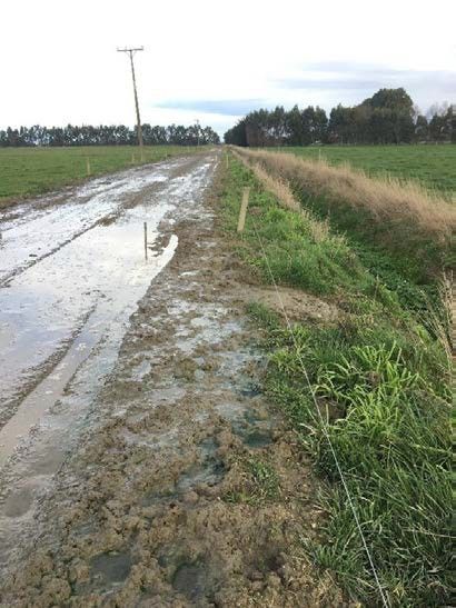
Woldwide 1 & 2

From Table 1.4 above, a cow eating 15.5 kg/DM/day will consume approximately 0.4kg of phosphorus per week,
of which 66% is excreted in dung. For a cow with a 290 day lactation (assume not walking on lanes outside of the
milking season) this equates to 10.9 kg/P/cow/yr. Cows are conservatively walking on the farm lanes for 1 hour
per day as they move to and from the dairy shed. This means 4% (1 hour is 4% of a day) of phosphorus excreted
is deposited on a lane. Overseer assumes 30% of this phosphorus is then lost to water via run-off.

((10.9 x 1500 cows) x 0.04) x 0.3 = 196 kg/P/yr lost to water from dairy lanes.

In total there are 10.8km of lanes on the farm of which 1.5km are adjacent to waterways and present a risk of
contaminant runoff. This represents 14% of the lanes on the farm and proportionally 28kg of the total phosphorus
losses from lanes. In reality this figure is likely to be higher as many of the other lanes on the property have no
hydraulic connection to waterways. On this basis, lanes beside waterways are likely to make up a much larger
proportion of the total phosphorus losses from the dairy lanes on the farm.

Assuming the conservative figure of 28 kg/yr of phosphorus loss from lanes adjacent waterways and the actions
contained in this plan are carried out (improved vegetative buffer strips and lane management) then phosphorus
losses from these areas are estimated to reduce by 40% (conservatively based on the lower end of the range of
38-59% of the data summarised in Figure 2 below). The exception to this is at site L12 where the use of the main
cow lane is to be reduced significantly (by at least 50%) due to the reconfiguration of the farms if consent is
granted. This is in addition to the management and vegetation buffer improvements. At this site a 60% reduction
phosphorus reduction factor has been used.

Overall phosphorus loss from lanes is estimated to reduce by 13.1kg/P/yr as outlined in the Table 1 below:

Site and Lane           % of Total Lanes        P Loss (kg)         Mitigations (%       Reduction in P
Length (m)                                                          Reduction)           Loss (kg)
L5 – 207                1.9                     3.7                 40                   1.5
L2 – 241                2.2                     4.3                 40                   1.7
L10 – 356               3.3                     6.5                 40                   2.6
L4 – 553                5                       9.8                 60                   5.9
L8 - 190                1.8                     3.5                 40                   1.4
                                                                                         13.1
Table 1 – Phosphorus Loss – Lanes

Phosphorus Loss – Critical Source Areas

Overseer predicts 101kg of phosphorus will be lost to water from paddocks (effective area of 478.9ha). Assuming
phosphorus loss occurs evenly over the effective area of the farm, then critical source areas and their associated
catchments would account for 2.5% of the phosphorus loss from blocks on the property. This equated to 2.5kg
of phosphorus.

Assuming a 50% reduction in phosphorus loss occurs through the implementation of wider, vegetated riparian
buffers (at locations where critical source areas enter waterways) and better management of critical source areas
then a further reduction of 1.2kg of phosphorus is estimated to occur beyond that modelled in Overseer. See
Table 2 below.

Site and                % of Total              P Loss (kg)         Mitigations (%       Reduction in P
Catchment Area          Catchment                                   Reduction)           Loss (kg)
L11 – 0.6ha             0.13                    0.13                50                   0.06
L3 – 0.7ha              0.15                    0.14                50                   0.07
L14 – 2.7ha             0.56                    0.57                50                   0.29
L9 – 7.5ha              1.57                    1.9                 50                   0.79
                                                                                         1.2
Table 2 – Phosphorus Loss – Critical Source Areas

The 50% reduction is based on research that shows management of critical source areas and vegetated buffers
can reduce phosphorus loss by 38-59% (Figure 1). A midpoint reduction figure of 50% has been used to account
for the likelihood of more phosphorus loss occurring in critical source areas than the rest of the farm and as such,
more potential for phosphorus loss reductions.

It is acknowledged by McDowell et al, 2005 in the original design of the Overseer sub-model that, in some areas,
90% of phosphorus loss may come from only 10% of the catchment area (Sharpley et al, 1999). McDowell states
that defining and isolating critical source areas, combined with adaptive management over the farm is the best
approach to decreasing phosphorus loss.
Woldwide 1 & 2 Figure 1 - Cost and effectiveness of strategies to mitigate phosphorus losses (McDowell et al, 2013) Based on the topography of the property, it is likely that significantly more phosphorus will be lost through a small number of critical source areas rather than evenly over the property. On this basis, the estimated phosphorus loss from critical source areas is likely to be underestimated and thus the overall reductions achieved from implementing riparian buffers and better management of critical source areas. References: Fertiliser and Lime Research Centre. (2014). Sustainable Nutrient Management Introductory Notes and Mastery Test. Massey University. Gray, C.W., Wheeler, D.M. and McDowell, R. (2016). Review of the phosphorus loss submodel in OVERSEER®. Report prepared for OVERSEER® owners under AgResearch core funding contract A21231(A). AgResearch. Report RE500/2015/050. McDowell, R; Monaghan, R and Wheeler, D. (2005). Modelling phosphorus losses from pastoral farming systems in New Zealand, New Zealand Journal of Agricultural Research, 48:1, 131-141. McDowell, RW; Sharpley, AN; Beegle, D and Weld J. (2001). Comparing phosphorus management strategies at the watershed scale. Journal of Soil and Water Conservation 56: 306-315. McDowell, R; Wilcock, B and Hamilton, D. (2013). Assessment of Strategies to Mitigate the Impact or Loss of Contaminants from Agricultural Land to Fresh Waters. Report prepared for MfE. AgResearch. Report RE500/2013/066. Sharpley, AN; Gburek, WJ; Folmar G and Pionke, HB. (1999). Sources of phosphorus exported from an agricultural watershed in Pennsylvania. Agricultural Water Management 41: 77-89.
Woldwide 1 & 2
LAND MANAGEMENT
Race Maintenance & Management
L2
Lane Adjacent Waterway (West of Wintering Barn)
IMPACT OF LIKELIHOOD OF
CONTAMINATION
+ CONTAMINATION =
DESCRIPTION:
Main lane to the west of the Woldwide One wintering barn running adjacent to a waterway. There is 1-2m riparian
buffer, which is wider to the north. Due to the location of farm infrastructure there is minimal opportunity to
extend the riparian margin wider. There is minimal vegetation cover in the riparian margin to filter any run-off.
It is recommended this area be planted in low native grasses such as red tussock and carex secta (1m intervals) to
filter any run-off and utilise the associated nutrients. As a minimum, the riparian buffer should be maintained in a
healthy sward of rank grass. In addition to this, any areas of the lane that slope towards the waterway should be
modified to slope in the opposite direction.
Estimated Reduction in Phosphorus: 1.7 Kg/P
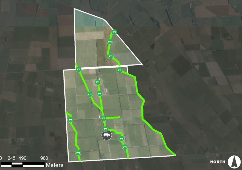
IMAGES:Woldwide 1 & 2 OPEN ACTIONS: Establish Vegetated Riparian Margin (Beside Barn) The riparian margin between the main dairy lane and the waterway to the west of the Woldwide One wintering barn should be maintained in a healthy vegetative cover. It is recommended native carex secta and red tussock are planted (1m spacing’s) in the riparian margin to filter run-off and utilise any associated nutrients. As a minimum the riparian margin should be maintained in a healthy sward of rank grass. TARGET DATE: 1st August 2020
Woldwide 1 & 2

    LAND MANAGEMENT

           Critical Source Area
  L3
           Critical Source Area (Paddocks 14-15)

  IMPACT OF                                            LIKELIHOOD OF
  CONTAMINATION
                                      +                CONTAMINATION
                                                                              =

DESCRIPTION:
Low lying area at the eastern end of paddocks 14 and 15 on either side of the dairy lane. At times water flows out
of the adjacent waterway into this area, which results in flooding of the dairy lane and water subsequently re-
entering the creek further downstream. The area is partly fenced off but is still grazed. The flooding appears to be
caused by a blocked or undersized culvert. Downstream of the culvert the creek is flows normally.

Being one of the few critical source areas on the farm and the fact water flows over the dairy lane means this area
is likely to have a disproportionately high loss of sediment and phosphorus compared to other areas of the farm.

It is recommended the culvert size be enlarged to prevent blockages/backing up of water and the resulting flooding.
In addition to this, the riparian margin where the gully enters the adjacent waterway should be extended and
maintained in rank grass (or planted in native grasses such as carex secta or red tussock) to filter any overland
flow that may occur under normal rainfall conditions.

Estimated Reduction in Phosphorus:        0.07 Kg/P

IMAGES:
Woldwide 1 & 2
15Woldwide 1 & 2
OPEN ACTIONS:
Increase riparian buffer(triangle paddock)
The riparian margin where the gully (Critical Source Area) enters the waterway should be extended and
maintained in rank grass (or planted in native grasses such as carex secta or red tussock) to filter any
overland flow that may occur under normal rainfall conditions. See photo above.
TARGET DATE: 1st August 2020
Enlarge Culvert (Paddocks 14-15)
The culvert on the main dairy lane running between paddocks 14 and 15 should be enlarged to prevent
blockages and flooding of the waterway into the adjacent paddock and lane. See Dairy NZ Waterway
Technical Manual (2016) for culvert sizing details.
TARGET DATE: 1st August 2020
16Woldwide 1 & 2
LAND MANAGEMENT
Race Maintenance & Management
L4
Central Lane (between WOL and WTL)
IMPACT OF LIKELIHOOD OF
CONTAMINATION
+ CONTAMINATION =
DESCRIPTION:
Main dairy lane running between Woldwide One and Woldwide Two. Currently this is used frequently by stock
from Woldwide Two to access paddocks to the south, south east and south west of the dairy shed. The
reconfiguration of the farm will result in a number of these paddocks being assigned to the Woldwide One Dairy
Platform and being accessed by different lanes. This will significantly reduce the frequency of stock movements
along this section of the central lane (minimum of 50% reduction in stock movements) and the corresponding
amount of dung (and associated phosphorus) deposited on the lane. In addition to the reduction in lane usage the
lane should be sloped away from the adjoining waterway and the riparian buffer extended by 1m and maintained
in rank grass (or planted in native grasses such as carex secta or red tussock).
Estimated Reduction in Phosphorus: 9.8 Kg/P
IMAGES:
17Woldwide 1 & 2
OPEN ACTIONS:
Reduction in Use of Central Dairy Lane
The reconfiguration of the central dairy lane between Woldwide One and Woldwide Two will result in a
significant reduction in stock movements along this section of laneway and a subsequent reduction in dung
(phosphorus) deposited on the lane.
TARGET DATE: New Consent Issued
Slope Lane and Extend Riparian Buffer-Central Lane
The lane should be sloped away from the adjoining waterway and the riparian buffer extended by 1m and
maintained in rank grass (or planted in native grasses such as carex secta or red tussock).
TARGET DATE: 1st August 2020
18Woldwide 1 & 2
LAND MANAGEMENT
Race Maintenance & Management
L5
Lane beside Waterway (Paddocks 18 & 19)
IMPACT OF LIKELIHOOD OF
CONTAMINATION
+ CONTAMINATION =
DESCRIPTION:
Main dairy lane running adjacent to a waterway. There is a small riparian buffer but this is not well vegetated and
provides minimal opportunity for filtering contaminants off the lane. The lane is relatively wide in this area and as
such it is recommended the fence be moved out 1m and a rank grass (or native plants such carex secta and red
tussock) be established to assist in filtering any run-off.
In a number of places the lane does slope away from the adjacent waterway but during upcoming lane
maintenance the entire lane should be sloped away from the creek.
Estimated Reduction in Phosphorus: 1.5 Kg/P
IMAGES:
19Woldwide 1 & 2
OPEN ACTIONS:
Extend Riparian Margin & Slope Lane
Extend the riparian margin by a minimum of 1m and establish a good sward of rank grass (or plant native
grass such as carex secta and/or red tussock) to assist with filtering run-off from the lane. In addition to this
slope the lane away from the waterway.
TARGET DATE: 1st February 2021
20Woldwide 1 & 2
LAND MANAGEMENT
L6
Culvert Management
IMPACT OF LIKELIHOOD OF
CONTAMINATION
+ CONTAMINATION =
DESCRIPTION:
Culvert crossing the waterway to the south of paddock 34. The culvert has no raised sides which allows any runoff
to flow off the side into the underlying water. Building up the sides of the culvert and directing run-off back into
the paddock or at a minimum into a grass riparian area will assist with filtering sediment and associated
phosphorus.
Estimated Reduction in Phosphorus: >0 Kg
IMAGES:
21Woldwide 1 & 2 Ltd
OPEN ACTIONS:
Build up sides of culvert (South of Paddock 34)
Build up the sides of the culvert crossing the waterway to the south of paddock 34. This will prevent the
direct deposition of sediment and associated phosphorus into the underlying waterway and allow for filtering
via a grass buffer.
TARGET DATE: 1st February 2021
22Woldwide 1 & 2
LAND MANAGEMENT
Critical Source Area
L7
Main Culvert (South of Wintering Barn)
IMPACT OF LIKELIHOOD OF
CONTAMINATION
+ CONTAMINATION =
DESCRIPTION:
The main lane culvert to the south of the wintering barn on Woldwide One. A kerb should be installed on the sides
of the concrete lane going over the culvert to prevent direct run-off into the underlying waterway. The kerb should
direct run-off back into the adjacent paddocks. On the western side of the culvert a triangle could be fenced off
and left in rank grass.
Estimated Reduction in Phosphorus: >0 Kg/P
IMAGES:
23Woldwide 1 & 2
OPEN ACTIONS:
Install Kerb - Main Culvert South Wintering Barn
Install a kerb on the concrete lane at the point it goes over the main culvert. This should direct run-off into the
adjacent paddock.
TARGET DATE: 1st February 2021
24Woldwide 1 & 2
LAND MANAGEMENT
Overland Flow Path
L8
Overland Flow Path (Paddock 15)
IMPACT OF LIKELIHOOD OF
CONTAMINATION
+ CONTAMINATION =
DESCRIPTION:
Fenced off strip at the southern end of paddock 15. Area used as an unformed lane to reach paddock 35. There is
an overland flow path down to the south west corner of paddock 15 where run-off can exit into the adjacent
waterway. The proximity of the unformed lane to the adjacent waterway also results in a high risk of run-off directly
into the creek. The temporary lane should be moved 2-3m back from the waterway when in use and the resulting
area left as rank grass to filter any run-off. The riparian buffer at the south west corner of paddock 15 should be
extended and maintained in rank grass (or planted in native grasses such as carex secta, red tussock and toetoe).
Estimated Reduction in Phosphorus: 1.4 Kg/P
IMAGES:
25Woldwide 1 & 2
OPEN ACTIONS:
Move Temporary Lane (Paddock 15)
The temporary lane should be moved 2-3m back from the waterway when in use and the resulting area left as
rank grass to filter any run-off. The riparian buffer at the low point at the south west corner of paddock 15
should be extended and maintained in rank grass (or planted in native grasses such as carex secta, red
tussock and toetoe).
TARGET DATE: 1st February 2021
26Woldwide 1 & 2
LAND MANAGEMENT
Overland Flow Path
L9
Critical Source Area (Paddock Marcel #1)
IMPACT OF LIKELIHOOD OF
CONTAMINATION
+ CONTAMINATION =
DESCRIPTION:
Swale/low area running through Marcel paddock 1. Overland flow will be concentrated in this area following
heavy rain and make its way down into the adjacent waterway. The riparian margin should be increased where the
swale enters the adjoining waterway and maintained in rank grass or planted in native grasses such as red tussock,
carex secta or toetoe.
Estimated Reduction in Phosphorus: 0.79 Kg/P
IMAGES:
27Woldwide 1 & 2
OPEN ACTIONS:
Extend Riparian Margin (Marcel #1)
Extend the riparian margin in Marcel Paddock 1 where the critical source area enters the adjoining waterway.
This area should be left in rank grass or planted in native grasses such as carex secta, red tussock or toetoe.
TARGET DATE: 1st February 2021
28Woldwide 1 & 2
LAND MANAGEMENT
Race Maintenance & Management
L10
Lane Adjacent Waterway (Paddock 34)
IMPACT OF LIKELIHOOD OF
CONTAMINATION
+ CONTAMINATION =
DESCRIPTION:
Dairy lane on the boundary of Woldwide One and Woldwide Two, south of paddock 34. The lane is lined on the
southern side with a row of tall gum trees, which will impact on the ability of the lane to dry out. There is a 1-1.5m
riparian buffer between the lane and the creek, which is maintained in rank grass. Some re-contouring of the lane
could occur to ensure it slopes away from the waterway along its full length. In addition to this the large gum trees
could be removed and replaced with low growing native plantings such as flax, toetoe and red tussock. This will
still provide stock shelter, aesthetic and biodiversity outcomes but not impact on the drying out of the lane.
Estimated Reduction in Phosphorus: 2.6 Kg/P
IMAGES:
29Woldwide 1 & 2
OPEN ACTIONS:
Modify Lane beside Creek (Paddock 34)
Re-contour the dairy lane at the southern end of paddock 34 (between Woldwide One and Woldwide Two) so
it slopes away from the dairy lane. In addition to this the gum trees could be removed to prevent shading of
the lane, allowing it to dry out (reducing the likelihood of water ponding and running off). This area could be
replanted in low natives such as flax, toetoe and red tussock to maintain biodiversity and aesthetic values.
TARGET DATE: 1st February 2021
30Woldwide 1 & 2
LAND MANAGEMENT
Overland Flow Path
L11
Overland Flow Path (Paddock 34)
IMPACT OF LIKELIHOOD OF
CONTAMINATION
+ CONTAMINATION
=
DESCRIPTION:
Small gully/swale running through paddock 34. In heavy rainfall events this will collect rainwater and associated
contaminants from the surrounding land and direct them down to the waterway. Extending the riparian buffer and
maintaining it in rank grass (or plant with native grasses such as Carex Secta or Red Tussock) in the location
where the swale enters the creek will assist with filtering sediment and associated phosphorus.
Estimated Reduction in Phosphorus: 0.06 Kg/P
IMAGES:
31Woldwide 1 & 2
OPEN ACTIONS:
Extend Riparian Margin (Paddock 34)
Extend the riparian margin where the small swale in paddock 34 enters the adjacent waterway. Maintain this
area in rank grass or plant in native grass species such as red tussock or carex secta.
TARGET DATE: 1st August 2021
32Woldwide 1 & 2
LAND MANAGEMENT
Critical Source Area
L12
Culvert - Woldwide Two Dairy Shed
IMPACT OF LIKELIHOOD OF
CONTAMINATION
+ CONTAMINATION =
DESCRIPTION:
Main culvert to the west of the dairy shed at Woldwide Two. The culvert could be improved to reduce the risk of
contaminants off the lane flowing into the underlying waterway by building up the sides of the culvert and creating
a wider buffer on the north side of the culvert where there is un-utilised space. Run-off should be directed off the
culvert into adjacent paddocks (where possible) or as a minimum into a grassed riparian area.
Estimated Reduction in Phosphorus: >0 Kg/P
IMAGES:
33Woldwide 1 & 2 Ltd
OPEN ACTIONS:
Build up Culvert Sides (Beside Woldwide Two Dairy Shed)
Build up the sides of culvert and create a wider riparian buffer on the north side of the culvert where there is
un-utilised space. Direct run-off into adjacent paddocks where possible or as a minimum into a vegetated
riparian margin.
TARGET DATE: 1st August 2021
34Woldwide 1 & 2 Ltd
LAND MANAGEMENT
Critical Source Area
L13
Culvert (Paddock Marcel#9)
IMPACT OF LIKELIHOOD OF
CONTAMINATION
+ CONTAMINATION
=
DESCRIPTION:
Lane culvert into Marcel Paddock #9. The culvert is in good condition along with the lane overlying it. The sides
of the culvert should be raised to prevent contaminants off the lane running directly into the underlying waterway.
Run-off should be directed out into the adjacent paddocks.
IMAGES:
OPEN ACTIONS:
Raise sides of culvert (Marcel #9)
Raise the sides of the culvert to prevent contaminants off the lane running directly into the underlying
waterway. Run-off should be directed out into the adjacent paddocks.
TARGET DATE: 1st August 2021
35Woldwide 1 & 2
LAND MANAGEMENT
Overland Flow Path
L14
Critical Source Area (Paddock 21)
IMPACT OF LIKELIHOOD OF
CONTAMINATION
+ CONTAMINATION
=
DESCRIPTION:
Shallow swale through paddock 21 that slopes down to the adjacent waterway. The swale will be a conduit for
overland flow off the surrounding paddock during heavy rainfall events. Due to the flat topography of the farm and
the small number of critical source areas, small swales as identified in paddock 21 are likely to carry a
disproportionately high level of contaminants compared to the rest of the farm. On this basis having a wider
riparian buffer where the swale enters the adjoining waterway and maintaining the buffer in rank grass or native
grasses such as carex secta or red tussock will filter contaminants and reduce losses to surface waterways.
Estimated Reduction in Phosphorus: 0.29 Kg/P
IMAGES:
36Woldwide 1 & 2 Ltd
OPEN ACTIONS:
Extend Riparian Buffer (Paddock 21)
Extend the riparian margin in the location where the low area through paddock 21 enters the adjoining
waterway. This should be maintained in rank grass or planted in native grasses such as Carex Secta, Red
Tussock or Toetoe.
TARGET DATE: 1st August 2021
37You can also read