La Niña: Outlook 2020-21 - Climate and Earth Observation, Research, Assessment and Monitoring Division - WFP
←
→
Page content transcription
If your browser does not render page correctly, please read the page content below
La Niña: Outlook 2020-21

Climate and Earth Observation, Research, Assessment and Monitoring Division

                                                             September 2020
La Niña Outlook – Summary
    • La Niña conditions are currently active and expected to last until the first quarter of 2021. While
      forecasts indicate that it is expected to remain weak to moderate, La Nina intensity is not a good guide
      to the magnitude of possible impacts.
    • This assessment includes historical data from previous La Nina seasons and current seasonal forecasts.
      Areas where La Nina impacts may be expected include the growing seasons of Southern Africa, Eastern
      Africa, SE Asia (wider Indonesian region) as well as Central America and the Caribbean to a lesser
      degree.
    • Perspectives for the Southern Africa growing season are optimistic given typical enhancement of
      seasonal rainfall during La Nina events, and indications from current forecasts. Regional maize
      production tends to be favourable in La Nina seasons.
    • In contrast, for East Africa perspectives are quite poor: the coming Short Rains (Oct-Dec) will most likely
      be drier than average, which will follow a poor harvest in 2020 due to floods and locust impacts.
      Indicative preliminary forecasts and historical data raise the possibility of drier than average conditions
      for the Long Rains season of March-May 2021. If realized, very considerable impacts on the food
      security of already vulnerable populations can be expected throughout 2021.
    • For the Indonesian region, wetter than average conditions are expected, balancing favourable
      agricultural perspectives with enhanced flood risks. For Central America and the Caribbean, following
      an intense hurricane season, wetter conditions are expected for the last phases of the Postrera season.
2
    La Nina Outlook 2020-21
La Niña Outlook – September 2020

                                                                                                                                                    Evolution of a La Niña indicator (Pacific sea
                                                                                                                                                    surface temperature anomaly) until mid 2021,
                                                                                                                                                    generated by the CPC models.

                                                                                                                                                    Black line is the consolidation of all models.
                                                                                                                                                    Dark grey and light grey shades contain results
                                                                                                                                                    from 68% and 95% of the models respectively
                                                                                                                                                    and provide an idea of the model’s uncertainty.
                                                                                                                                                    From: NASA ENSO Blog:
                                                                                                                                                    https://www.climate.gov/news-
                                                                                                                                                    features/blogs/enso/september-2020-enso-
                                                                                                                                                    update-la-ni%C3%B1a-here

             CPC/IRI ENSO Forecast from September. Blue bars denote probability of
             a La Niña developing in the near future

    Is a La Niña taking place and for how long?                                                    How does it compare with previous events?
    Yes. La Niña conditions are now present across the equatorial Pacific with a 75% chance        The last intense La Niñas took place back to back from late 2010 to early 2012. Since
    of remaining in place during late 2020 and early 2021.                                         then, there have only been short and weak-borderline La Niñas in 2016-17 and
    The evidence indicates that this La Niña is likely to be over around March-April 2021: see     2017-2018. Weak as it was, the first of these episodes led to drought in Somalia and
    likelihoods dropping significantly (chart left) and the forecast indicator crossing back the   the wettest season in Zimbabwe for more than 35 years.
    La Niña threshold around March-May (chart right).
                                                                                                   What can we expect?
    How intense will it be?                                                                        Impacts, their intensity and timing are varied across the globe. This report presents
    The event is expected to remain weak to moderate: the chart above right shows the              an outlook for each WFP region based on:
    indicator barely going below the -1C threshold of a moderate La Niña. However, the                    • Latest seasonal forecast information
    intensity of the event is not a good guide to the magnitude of possible impacts. Seasonal             • Expectations based on 40 years of data records
    forecasts are a better source of guidance as they produce geographically specific
    information for the periods under the likely La Niña lifetime.

3
      La Nina Outlook 2020-21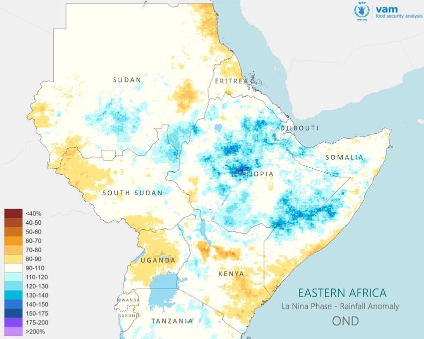
La Niña Timeline and Growing Seasons
                                    2020
                                    2018                                                                         2019
                                                                                                                 2021
             Sep              Oct          Nov         Dec            Jan        Feb   Mar          Apr           May             Jun             Jul            Aug     Sep
         La Niña Evolution
                                                   Peak intensity

                                                                   SOUTHERN AFRICA

                                    HORN OF AFRICA (SHORT RAINS)                        HORN OF AFRICA (LONG RAINS)

                                                  INDONESIA, PHILIPPINES                                                                   ASIA (INDIA, SE ASIA)

                 CENTRAL AMERICA (POSTRERA)
                                                                                                                                      WEST AFRICA, SUDANS, ETHIOPIA (MEHER)

                         Coverage by Seasonal Forecasts
                                                                                          Generalized growing season timing across WFP regions in relation to likely
                                                                                          La Niña timing and intensity. Seasons overlapping with the La Niña event
                                                                                          are more likely to be affected than those with little or no overlap.

     Which regions will be impacted by a possible La Niña ?                            Considering the broad timings of La Niña and of growing seasons around the world in the
                                                                                       next 12 months, this event is most likely to be affected the following growing seasons:
     Current forecasts offer a tentative timing for the current La Niña event: a
     start in August 2020 and a likely end towards March-April of 2021, with a                 •   Southern Africa
     peak around December 2020.                                                                •   East Africa (Short Rains and Long Rains to a lesser degree)
     The greater concern is with regions where the coming growing season                       •   Indonesia and Philippines (to a lesser degree)
     overlaps with the La Niña event, enabling it to influence seasonal outcomes.              •   Latin America and Caribbean (late stages and hurricane season)
                                                                                       If La Niña is prolonged beyond what is currently expected, early stages of the season in SE
                                                                                       Asia and possibly West Africa might be affected.
4
    La Nina Outlook 2020-21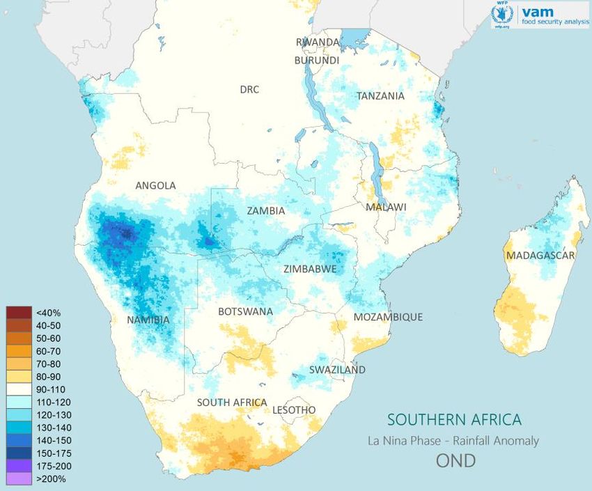
La Niña Effects: Sources of Evidence
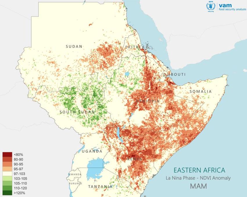
Evidence : Rainfall and NDVI long term records
Long term (30-40 years) records of rainfall estimates and vegetation indices (NDVI) offer a simple way to map
likely ENSO influences: the record is split into groups corresponding to the two ENSO phases (El Nino, La Nina)
and Neutral. For each group, a long term average is derived.
An ENSO Anomaly is formed by comparing (ratio) the mean rainfall / NDVI in a given ENSO phase with the mean
rainfall in Neutral seasons. When mapped, these anomalies highlight areas where there is an ENSO effect and
the sign of the effect:
Below [above] 100%, the ENSO phase will decrease [increase] rainfall / NDVI relative to those of neutral
seasons. The further away from 100% the more intense is the effect. The map below shows a strong increase in
rainfall in Jan-March during La Niña seasons across Botswana and Zimbabwe and some reduction in NW Angola.
Example of a seasonal forecast from IRI for Oct-Dec 2020 rainfall.
Map shows most likely rainfall category. Browns for below
Example of ENSO anomaly: average, greens for above average.
Jan-March rainfall for
Southern Africa during La Evidence : Seasonal Forecasts
Niña seasons as a percent Seasonal forecasts are available from a number of international and regional
of the average in neutral
seasons. Blues for La Niña
centres, as probabilities of 3 month rainfall amounts being below, on or above
wetter than neutral, average or of rainfall being above a long term reference.
oranges for La Niña drier
Most look ahead for up to four overlapping 3-month periods. So forecasts
than neutral.
issued in September provide users with information up to the Dec-Feb period.
5
La Nina Outlook 2020-21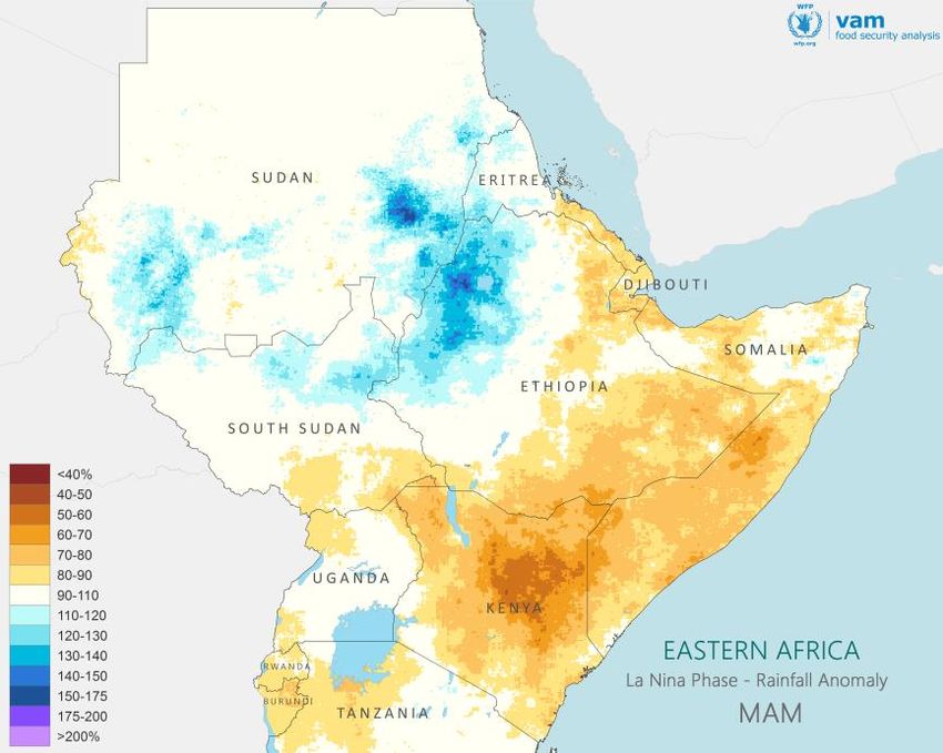
Southern Africa:
               Hopes of Improvements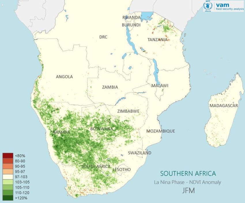
Southern Africa: Historical La Niña Effects

October-December rainfall during La Niña seasons as a percent of the   January-March rainfall during La Niña seasons as a percent of the average           January-March NDVI during La Niña seasons as a percent of the average in
average in neutral seasons.                                            in neutral seasons.                                                                 neutral seasons.

                                                                                                                                                   Blues or Greens for La Niña above neutral, yellows or browns for La Niña below neutral.

 Expectations from the historical record:
 Based on analysis of long term rainfall and vegetation data records, the general effect of La                         These historical tendencies for wetter than average conditions during La Niña
 Niña in this region is to enhance rainfall throughout the season, relative to neutral seasons.                        seasons are clearly reflected in the historical vegetation response: areas of
 In the early season (Oct-Dec, map above left), the effect extends from Namibia, southern                              enhanced rainfall also show denser than usual vegetation cover (areas in green,
 Angola and into Zambia, Zimbabwe and Mozambique. In South Africa, there is a tendency for                             map above right).
 drier than average conditions in the south of the country.
                                                                                                                       Hence, based on historical data, the expectation is for a favourable growing
 This tendency for enhanced rainfall becomes stronger in the mid stages of the season (Jan-                            season with abundant and timely rainfall, leading to optimistic perspectives for
 March, map above middle) when wetter than average conditions expand across a wider area                               crop production and pastoral resources. This is balanced by an enhanced flood
 and intensify. Only in NW Angola there are some signs of drier conditions.                                            risk across major river basins of the region.

7
      La Nina Outlook 2020-21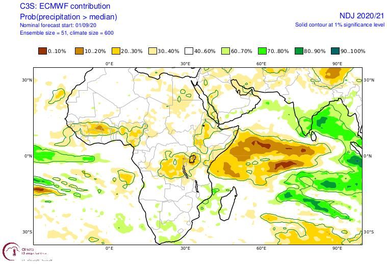
Southern Africa: Seasonal Forecasts
                                       Early Season: October-January
    OND                                Available seasonal forecasts overall indicate
                                       average or moderately above average
                                       rainfall for the first half of the Southern
                                       Africa rainfall season. ECMWF (and other
                                       models) and SADC consensus outlook
                                       indicate average conditions, while models
                                       from IRI and CPC point to above average
                                       rainfall.

                                       Outlook:
                                       The outlook for the early stages of the
                                       agricultural season is moderately favourable
                                       with suitable conditions for planting and
                                       early crop development.
                                       A similar outlook applies to pastoral
                                       resources; areas affected by drought in the
                                       previous season should now see a degree of
                                       recovery.

                                  Above left: SADC Consensus Outlook for Oct-Dec rainfall in southern Africa. Drier than
                                  average conditions expected in yellow areas, wetter than or close to average in blue areas.
                                  Below left: NMME Oct-Dec rainfall anomaly – green for wetter than average, browns for
                                  drier than average.
                                  Above right: ECMWF, Likelihood of Nov-Jan rainfall being above median – green for wetter
                                  than median, reds for drier than median.
                                  Below right: IRI, Most likely Category for Nov-Jan rainfall – green for wetter than average,
8
    La Nina Outlook 2020-21       browns for drier than normal.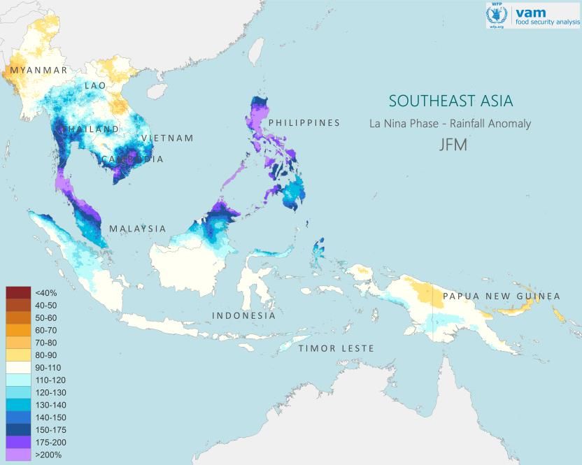
Southern Africa: Seasonal Forecasts
                                        Mid Season: December to March
            DJF                         Available seasonal forecasts indicate overall
                                        moderately above to close to average rainfall for
                                        the core (mid) period of the Southern Africa
                                        rainfall season. All models are in broad agreement
                                        with each other.
                                        The majority of models show the most favourable
                                        tendencies happening in the western areas of the
                                        region, western South Africa, Namibia, Botswana
                                        and parts of Angola. Close to normal conditions
                                        are forecast for the rest of the region.

                                        Outlook:
                                        These tendencies lead to a favourable outlook for
                                        the current season: Good conditions in the early
                                        season are likely to be followed by favourable mid-
                                        season rainfall. Agricultural production should
                                        reach average levels at least and good conditions
                                        for pastoral livelihoods are expected.
                                        These forecasts have a downside of increased
                                        flood risk in case of prolonged heavy rainfall.
                                        Note that these are broad tendencies at 3 month
                                        scales. Favourable tendencies do not preclude the
                                        occurrence of sharply dry episodes.

9
    La Nina Outlook 2020-21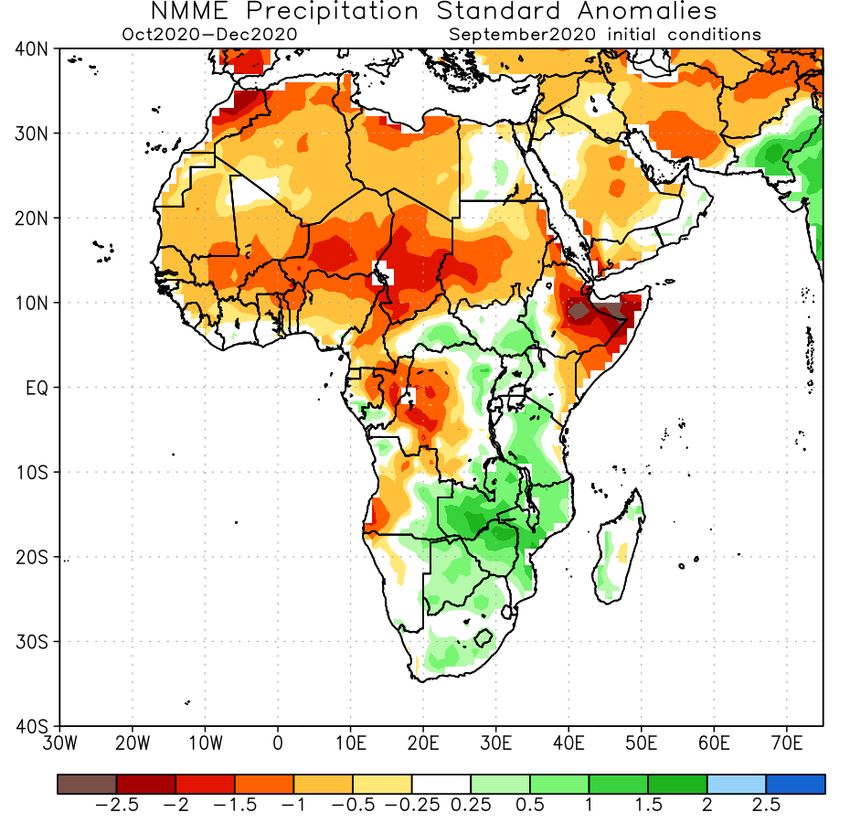
Southern Africa: Crop Production vs ENSO
                                                                                                                                          Chart showing variations in regional maize production
                                                                                                                                          from a 5 year mean colour coded according to the
                                                                                                                                          ENSO phase of the producing season.
                                                                                                                                          Regional production is based on data from South
                                                                                                                                          Africa, Zambia, Zimbabwe, Mozambique and Malawi.

     ENSO events have a well defined impact on crop production at regional scale.              However, the magnitude of the production drops is not well related to the magnitude of
                                                                                               the ENSO event. Out of the countries that contribute to the regional total, South Africa
     The chart above shows variations in regional maize production from the 5 year mean
                                                                                               is the one for which production variations are more closely tied to ENSO phase.
     colour coded according to the ENSO phase affecting the growing season. Drops in
     production (negative variations in orange) are mostly associated with El Nino events.     This historical data contributes to expectations of a favourable maize production for the
     The reverse is true for increases in production (positive variations in blue) which are   region as a whole and for most of the major producing countries – the link of maize
     associated with La Nina events.                                                           production to ENSO is stronger for the major producer and for Zimbabwe.
                                                                                               Therefore there are better perspectives for the lean period of late 2021, given likely
10
                                                                                               improvement in regional and national maize stocks.
     La Nina Outlook 2020-21
East Africa:
Risk of Back to Back DroughtsEast Africa: Historical La Niña Effects
October-December rainfall during La Niña seasons as a percent of the March-May rainfall during La Niña seasons as a percent of the average in March-May NDVI during La Niña seasons as a percent of the average in
average in neutral seasons. neutral seasons. neutral seasons.
Blues or Greens for La Niña wetter/greener than neutral, yellows or reds for La Niña
drier or less green than neutral seasons.
Expectations from the historical record:
East Africa has two rainfall seasons, the Short Rains (Deyr) from October to December and the Vegetation levels in La Niña seasons reflect this drier tendency: NDVI during
Long Rains (Gu) from March to May. In areas where rainfall is spread along the year, these remain March-May is markedly depressed relative to neutral seasons (areas in red, map
the wettest periods of the year. above right).
Based on long term rainfall and vegetation data records, the general effect of La Niña in this region Hence, based on the historical data, the expectation for East Africa is for drier
is to decrease rainfall compared to neutral seasons. For the Short rains (Oct-Dec) the effect is most than average conditions for both rainfall seasons, with stronger tendencies in the
pronounced along SE Somalia and eastern Kenya, Uganda and areas of Eritrea and coastal Sudan. Long Rains season (March-May).
For the Long Rains (Gu) of March to May, this tendency for decreased rainfall is stronger and more This leads to pessimistic perspectives for crop production and pastoral resources,
widespread mainly affecting the whole of Kenya, SE Ethiopia and Afar and most of Somalia. likely affecting both rainfall seasons.
12
La Nina Outlook 2020-21Eastern Africa: Deyr/Short Rains Seasonal Forecasts
Seasonal forecasts for the Short Rains are unanimously
indicating drier than average conditions during this
period. Differences between forecasts are only in the
degree of the likely rainfall deficits.
Hence from both current forecasts and historical data,
the most likely scenario is for drier than average
conditions throughout the Short Rains seasons. Crop
production and pastoral resources will therefore be
negatively impacted.
While the Short Rains are a secondary season in terms
of crop production, they play an important role of
supporting agricultural and pastoral livelihoods right
after the long dry season and improving soil moisture
reserves.
The likely poor performance of the coming Short Rains
follows a depressed crop production in the previous
season of March-May 2020 as a result of flooding and
desert locust infestation.
NMME Oct-Dec rainfall anomaly – green for wetter than average, A poor Short Rains season will lead to worsening food
reds for drier than average.
security conditions as a result of enhanced vulnerability
from the impact of poor crop production and Covid-19
related economic fallout.
GHACOF Seasonal forecast for Oct-Dec rainfall in East Africa.
Greens denote areas of on or above average rainfall, Yellows areas of below
average rainfall
13
La Nina Outlook 2020-21Eastern Africa: Gu/Long Rains Perspectives
Available seasonal forecasts do not yet cover the Long Rains of March-May Even if these March-May perspectives are tentative, they warrant serious
2021, so forecast guidance is not available. consideration given the context in which a poor outcome of the Long Rains
season would take place.
Historical data shows that low March-May (MAM) rainfall is a feature of La Nina
seasons: across large parts of the region, seasonal rainfall reaches only 80-70% If indeed the March-May rains are unfavourable and assuming a poor
of the average down to only 50-60% in some hot-spots. performance of the Short Rains as given, this area of East Africa will have
endured three seasons with poor agricultural and pastoral performance. This
Another line of work offers predictive indications on the outcomes of the Long will further increase food insecurity levels in the region and place vulnerable
Rains season. This is based on analysis by scientists at the Climate Hazards populations in great risk at the outset of the long dry season of June-October
Centre (Univ California, Sta Barbara), indicating that certain specific sea surface 2021.
temperature (SST) patterns can amplify modest La Niña-like conditions and help
produce droughts extending over both Short and Long Rains seasons (see links
below).
The analysis indicates that March-May 2021 may also be drier than usual. This
is based on a number of considerations: SST patterns around that time are
forecast to be similar to those that have driven rainfall deficits in the past. MAM
rainfall has been in a long term decline even if punctuated by exceptionally wet
seasons arising from increasing inter-annual variability.
Note that these predictions apply only to eastern Kenya, SE Ethiopia and
southern-central Somalia, not to the wider East Africa region.
https://blog.chc.ucsb.edu/?p=774, https://blog.chc.ucsb.edu/?p=790, https://blog.chc.ucsb.edu/?p=868
Examining the role of unusually warm Indo‐Pacific sea‐surface temperatures in recent African droughts, Funk et al, 2016, Quart Journal Royal Met. Society
14
La Nina Outlook 2020-21Other Regions
SE Asia: La Niña Summary Outlook

                                                                                 June-August 2020 rainfall as a percent of average.
                                                                                 Blue shades for wetter than average, orange                         Rainfall forecasts for Oct-Dec 2020 rainfall. Orange shades
                                                                                 shades for drier than average.                                      for drier than average, greens for wetter than average

     Typically, La Nina leads to wetter than average conditions across Indonesia, Philippines, Papua New Guinea and the
     Pacific Islands. Seasonal forecasts for the last quarter of 2020 are consistent with this tendency (map above right).
     The season so far in Asia has been variable with good conditions in Pakistan and India, Malaysia and Thailand. A
     drier season affected Myanmar and eastern areas of SE Asia (Cambodia and Vietnam). However, for these regions,
     most forecasts indicate moderately above average rainfall for the later part of 2020.
     Indonesia and southern Philippines already had a wetter than average seasonal drier period in mid 2020; the main
     season will start in a month or so and most likely will be wetter than average throughout its duration. The historical
     La Nina rainfall for Oct-Dec shows rainfall enhancement around Indonesia; for early 2021, similar enhancement is
     seen but more towards Malaysia, northern Borneo, Philippines.
     This outlook implies that good conditions for crop production but with a downside of flood and flash flood hazards
     being more likely in the next six to eight months.

                                                     Average Jan-March rainfall in La Nina seasons as a percent of the average in neutral seasons.
16
       La Nina Outlook 2020-21                       Blue shades for wetter than neutral, orange shades for drier than neutral
Central America: La Niña Summary Outlook
The current season has been variable across Central
America and the Caribbean. For most of Central
America, the Primera (first) season has developed
broadly in normal terms, but significant rainfall deficits
have affected Haiti (map above left).
The initial stages of the Postrera season have been
generally drier than average particularly in western
Nicaragua, Cuba and Haiti (map below left).
Conditions may improve soon, as nearly all seasonal
forecasts indicate wetter than average conditions for
the last quarter of 2020 (map above right). The main
difference between forecasts is on the extent of the
favourable rainfall; specifically whether it will include Rainfall forecasts for Oct-Dec 2020 rainfall. Orange shades for
Cuba and Haiti, or whether these will instead be drier than average conditions, greens for wetter than average
affected by the drier conditions forecast to
predominate in more northern areas.
A major impact of La Nina has been a very active
hurricane season with enhanced storm frequency.
In principle, the La Nina is not expected to last enough
to affect the Primera season of mid 2021. In case it
does, its very early stages tend to be drier than average,
based on the historical data.
Average March-May rainfall during
May-July 2020 rainfall (above) and one month rainfall to Sept 10 (below) as
La Nina seasons as a percent of the
a percent of average. Blue shades wetter than average. Browns for drier
average in neutral seasons.
than average conditions.
Blue shades for wetter than neutral,
orange shades for drier than neutral
17
La Nina Outlook 2020-21DATA SOURCES: FOR FURTHER INFORMATION:
Rainfall: CHIRPS, Climate Hazards Group, UCSB Rogerio Bonifacio
Vegetation: MODIS NDVI, EOSDIS-NASA rogerio.bonifacio@wfp.org
Land Cover: ESA CCI
+39 06 6513 3917
PROCESSING:
VAM software components, ArcGISYou can also read