AUSTRALIAN SEASONAL BUSHFIRE OUTLOOK: DECEMBER 2020 - FEBRUARY 2021
←
→
Page content transcription
If your browser does not render page correctly, please read the page content below
ISSUE 85 NOVEMBER 2020
TOPICS IN THIS EDITION | FIRE IMPACTS | FIRE SEVERITY | FIRE WEATHER

AUSTRALIAN SEASONAL BUSHFIRE
OUTLOOK: DECEMBER 2020 – FEBRUARY 2021
OVERVIEW
Australia’s climate is now under the influence
of La Niña, and as a result the landscape and
weather conditions continue to be vastly
different to the previous two years. The year to
date has seen average to above average rainfall
across much of the south east and north
west of the country. This rainfall continued
through spring, resulting in prolific grass
growth in south eastern and central areas.
Grass and crop fires are the main concern in
these locations for the summer months as
the growth dries out in the warmer weather.
Grass and crop fires are fast moving and can
spread rapidly when fanned by strong winds.
  These conditions mean that large parts of                   Above normal fire potential
New South Wales west of the Great Dividing                    Normal fire potential
Range face above normal fire conditions, as                   Below normal fire potential
well as grassland areas of the ACT and into
north eastern Victoria. Western Australia has
                                                      Figure 1: AUSTRALIAN SEASONAL BUSHFIRE OUTLOOK: DECEMBER 2020 – FEBRUARY 2021. AREAS ARE BASED
largely missed out on the rainfall in 2020            ON THE INTERIM BIOGEOGRAPHIC REGIONALISATION FOR AUSTRALIA AND OTHER GEOGRAPHICAL FEATURES.

and conditions are very dry, with parts of the
south and south west coasts expecting above        land use types (such as agriculture,                       DEFINITION
normal fire conditions through summer.             forestry, public land) and vegetation types                Bushfire potential: The chance of
  Although large parts of the east coast           (forests, grasslands, deserts). This in turn               a bushfire or number of bushfires
were affected by bushfires last season,            is influenced by different forecasts for                   occurring of such size, complexity or
and wetter than average conditions are             temperature and rainfall over these regions.               other impact that requires resources
expected over this summer, normal fire               The Australian Seasonal Bushfire Outlook:                (from both a pre-emptive management
conditions are still expected for much of          December 2020 – February 2021 is developed                 and suppression capability) beyond
these forested areas due to the long-term          by the Bushfire and Natural Hazards                        the area in which it or they originate.
dryness that still persists and the significant    CRC, AFAC, the Bureau of Meteorology,                      Bushfire potential depends on many
amount of area that was not burnt.                 Queensland Fire and Emergency Services,                    factors including weather and climate,
  The Australian Seasonal Bushfire Outlook:        the New South Wales Rural Fire Service, ACT                fuel abundance and availability,
December 2020 – February 2021 covers               Emergency Services Agency, ACT Parks and                   recent fire history and firefighting
all states and territories. It reflects the        Conservation Service, Country Fire Authority,              resources available in an area.
priorities in each state and territory for the     Department of Environment, Land, Water
coming months given the expected climate           and Planning Victoria, Tasmania Fire Service,
conditions, and provides information to            Country Fire Service, Department of Fire               of rainfall are critically important when
assist fire authorities in making strategic        and Emergency Services and Department of               estimating vegetation (fuel) volumes
decisions such as resource planning and            Biodiversity, Conservation and Attractions             and growth. The climate outlook for
prescribed fire management to reduce               Western Australia, and Bushfires NT.                   the next few months is also a crucial
the negative impacts of bushfire.                                                                         factor. Of particular interest are the
  Fire potential can vary greatly, even at         OUTLOOK – SUMMER 2020/21                               future tendencies of Pacific sea surface
the smaller scale, between bordering states        Fire management is a year-round process,               temperature associated with the El Niño-
and territories. Each state and territory’s        and bushfire potential depends on many                 Southern Oscillation, as well as the Indian
assessment takes into account different            factors. The volume, location and timing               Ocean Dipole – major climate drivers over

              | All Hazard Notes are available at www.bnhcrc.com.au/hazardnotes                                                                         1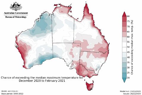
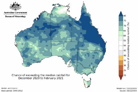
Figure 2:   RAINFALL DECILES 1 JANUARY TO 25 NOVEMBER 2020.                          Figure 3:  CHANCE OF EXCEEDING THE MEDIAN RAINFALL
                                                                                            FOR DECEMBER 2020 TO FEBRUARY 2021.

    Australia. Other less quantifiable factors,                  Satellite monitoring of vegetation health          on the changes observed, see the recently
    such as the distribution and readiness of                 suggests some areas that have experienced             updated State of the Climate 2020 report
    firefighting resources, are also considered.              above average rainfall in recent months               from the Bureau of Meteorology and CSIRO.
      With La Niña climate conditions reached                 are now observing a significant increase in
    in mid-September, the rainfall outlook                    grass vegetation growth. This includes large          CLIMATE OUTLOOK
    through to the end of summer suggests                     areas of New South Wales to the west of the           The Bureau of Meteorology’s climate
    above average rainfall is likely over much of             ranges, parts of western Victoria, and south          outlooks are based on the physics of
    the country. However, these months are a                  east South Australia. A period of dry weather         the oceans, atmosphere, land and ice.
    drier time of the year for much of southern               in summer can rapidly dry out this type of            They implicitly include all current climate
    Australia. Some southern parts of South                   vegetation, creating fuel for grass fires.            drivers, including long-term trends.
    Australia and Western Australia have largely                 The long-term warming trend means that                The climate influences of 2020 are very
    missed out on recent rainfall and are very dry.           above average temperatures now dominate               different to those that led to the extreme dry
      For future updates on fire potential                    most years, and recent months have generally          conditions in 2019. A La Niña event is currently
    during summer 2020/21, visit your                         followed this pattern. September 2020 was             active in the tropical Pacific Ocean. La Niña
    rural fire agency website.                                Australia’s second warmest September since            typically results in above average spring
                                                              national records began in 1910. Preliminary           and summer rainfall over much of eastern
    RECENT CONDITIONS                                         data indicates that November 2020 may                 and northern Australia. Combined with
    Seasonal fire conditions are a function of                also be one of the warmest November’s                 other drivers that enhance rainfall, including
    fuel (vegetation) amount and dryness,                     on record. High temperatures add to the               warmer than average waters to the north of
    and seasonal weather conditions.                          impact of reduced rainfall by increasing              Australia and a positive Southern Annular
    Australia’s weather and climate in 2020                   evaporation. Despite high temperatures in             Mode that is forecast to persist until late
    has been markedly different to 2019. In                   the north and west of the country lifting             2020, much of Australia is expected to see
    2020, rainfall has been average to above                  the national average, cooler than average             wetter than average conditions over summer.
    average across much of the south east and                 days have been experienced across large                  The rainfall outlook for December to
    north west of the country (see Figure 2,                  parts of inland south east Australia.                 February (Figure 3, above) shows that wetter
    above), whereas 2019 was Australia’s                         Rainfall so far in 2020 has eased the              than average conditions are very likely
    warmest and driest year on record.                        fire risk for parts of eastern Australia,             for nearly all of Australia except western
      A La Niña is now well established in the                however southern South Australia and                  Tasmania, where there is an increased chance
    tropical Pacific and is likely to persist until           Western Australia have seen drier and                 of drier than average conditions. Historical
    at least the end of summer, potentially                   warmer conditions persist this year. More             outlook accuracy for December to February
    peaking in December or January. La Niña                   rainfall is needed across many areas to fully         is very high across much of Australia, but
    events typically increase the likelihood                  recover from the extreme dry of 2019/20.              generally moderate to low around central
    of above average rainfall across much                        The tendency for fire seasons to become            and southern parts of the Northern Territory
    of Australia during spring, and across                    more intense and for fire danger to occur             and the Queensland border, and some
    much of eastern Australia during summer.                  earlier in the season is a clear trend in             parts of north eastern New South Wales.
    Above average rainfall since August over                  Australia’s climate, reflecting reduced                  Average maximum temperatures for
    some areas of eastern Australia has eased                 and/or less reliable cool season (April to            December to February are likely to be
    rainfall deficiencies. However, south west                October) rainfall and rising temperatures.            higher than the long-term average for
    and southern Western Australia, and                       Fire season severity is increasing across             Victoria, Tasmania, the far west of WA, the
    some of the southern agricultural areas of                much of Australia as measured by annual               northern coastlines of NT and Queensland,
    South Australia, have not received above                  (July to June) indices of the Forest Fire             parts of eastern SA, southern Queensland,
    average rainfall. As a result, south west                 Danger Index, with increases tending to be            and western NSW. However, the average
    Western Australia has seen an increase in                 greatest across inland eastern Australia and          maximum temperature is likely to be below
    the area in drought over recent months.                   coastal Western Australia. For more details           the long-term average for south coast WA,

2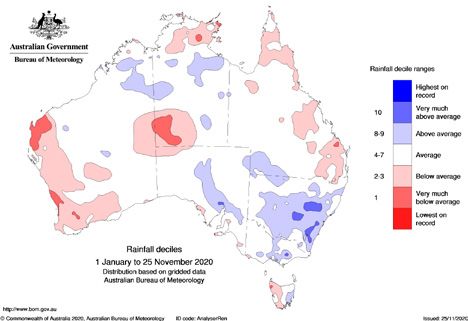
Figure 4:  CHANCE OF EXCEEDING THE MEDIAN MAXIMUM                                Figure 5: CHANCE OF EXCEEDING THE MEDIAN MINIMUM
   TEMPERATURE FOR DECEMBER 2020 TO FEBRUARY 2021.                                  TEMPERATURE FOR DECEMBER 2020 TO FEBRUARY 2021.

north east WA, and north west NT. (Figure 4,           Queensland. This rainfall is likely to trigger      For the majority of areas, this is expected to
above). Elsewhere, temperatures are likely to          good grass growth, particularly along               be highest from mid to late summer. Hot and
be close to the long-term average. Average             coastal areas. The forecast rainfall and            windy days will increase the fire risk and this
minimum temperature for the same period                maximum temperatures indicate that it will          will continue to be monitored closely. Higher
is very likely to be above the long-term               be unlikely that this new grass growth will         grass fuel loads can increase fire danger by
average across Australia (Figure 5, above              cure off during summer. This has resulted           increasing the intensity of grass fires. All
right). Historical accuracy for December               in an assessment of normal fire risk,               other factors being equal, this increase of
to February maximum temperature                        however the grass fire risk will continue to        the intensity makes the fires hotter, more
outlooks is moderate to high across all of             be monitored over the coming months.                dangerous, and harder to put out. As a result,
Australia except the NT. Historical minimum                                                                above normal fire potential is expected for
temperature outlook accuracy is moderate               NEW SOUTH WALES                                     the predominantly grassland areas on and
to high across much of Australia, very high            With a La Niña underway in the                      west of the Divide. In these areas, there is
in Victoria and Tasmania, and low around               tropical Pacific, the summer rainfall               a high risk of high intensity grass fires that
central NT and central parts of Queensland.            outlook appears favourable for above                could impact communities this season.
  The tropical cyclone season, which                   average rain for much of NSW.
typically starts in November, is likely to               The fire outlook for forested areas that          ACT
be more active this season than in recent              were not affected by last season’s fires            The ACT has received significant rainfall
years for Queensland, the NT and WA due                remains at a normal level for this fire season.     in recent months which has resulted in
to the influence of La Niña. While this may            Like most seasons, there is always a risk           vigorous grass growth. While abundant
increase the chance of rainfall, areas of              that if fires occur, particularly around the        in amount, this grass is currently seeding
increased wind could potentially interact              interface of high population centres of             and is predominately uncured and too
with any fires in the south of the country.            Sydney, Illawarra and the Hunter, they could        damp to burn in a high-risk way. This is
  Updates to climate forecasts, including              quickly impact on houses and infrastructure.        expected to change over summer, as while
forecasts of monthly, fortnightly and weekly           In these areas there is a need to monitor           November and December is the normal
outlooks and the outlook for the Indian                for escalation to fire danger associated            time for annual grasses to set seed and
Ocean Dipole and the El Niño–Southern                  with prolonged heatwaves that can occur             then die-off, this season may instead see
Oscillation, will continue to be published             during La Niña years as a result of more            a second round of flowering, increasing
at www.bom.gov.au/climate/ahead.                       heat being retained in the atmosphere.              the growth and therefore grass fire risk
                                                         The rain received through spring has              once the grass dries. As a result, there is
REGIONAL SUMMARIES                                     resulted in prolific grass growth west of the       above normal risk of fires in these grassland
                                                       Great Dividing Range. These ideal growing           areas and this will be closely monitored
QUEENSLAND                                             conditions for cropping and grassland areas         by the ACT Emergency Service Agency.
Recent rainfall, particularly across                   are expected to continue in coming months              Due to the amount of rain received, forest
south eastern Queensland, has seen an                  with the combination of above average               vegetation is too damp to support fast
improvement in fire risk conditions. Despite           rainfall and warmer than average minimum            running or large bushfires. It is expected
this recent rain, large parts of the state             temperatures forecast. This growth has              that these conditions will continue for some
are carrying very low to average grass fuel            already increased the grass and crop fuel           time. Should drying conditions emerge
loads relative to long-term records. Long-             loads, and this is expected to continue             during the coming months in these forested
term rainfall deficits still persist across            throughout summer. Reports of lower                 areas, the community will be advised by
large parts of the state and significant               stocking levels after the drought means             the ACT Emergency Services Agency.
additional rainfall is needed to overcome              that reduction of fuel loads by grazing may            ACT residents need to review their
this underlying sub soil dryness.                      not be as high as what would normally be            bushfire plans with a particular focus on
  The current La Niña conditions favour                expected. The risk for this period will be          grass fire risk, and to manage grasses near
above average rainfall across much of                  dependent on grass curing or drying rates.          their property to prevent potential impacts

                                                                                                                                                             3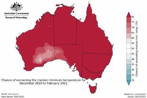
of fast-running grass fires. It is important             significant amount of rain in a historically wet       in the root zone this year. This has increased
    to clear around fences. Rural residents are              area. With the current climate drivers, it is          the fire potential to above normal for parts
    advised to place and maintain strategic                  likely this somewhat unusual rainfall pattern          of the Nullarbor and Eucla bioregions. In
    breaks to check fire runs. Fire services and             will persist and possibly intensify. Therefore,        addition, although planned burning and past
    land managers will also be implementing                  eastern Tasmania may have a quiet fire season,         bushfires have reduced fuel loads across some
    plans to further mitigate that risk.                     while the fire potential in the south west may         forested areas of the South West, there are
                                                             increase in late summer due to the availability        still areas of forest and shrubland vegetation
    VICTORIA                                                 of peat soils, moist scrubs and forests to burn.       that have experienced a prolonged rainfall
    Victoria experienced below average                                                                              deficit and are carrying significant surface
    rainfall for most of the state during winter             SOUTH AUSTRALIA                                        fuel loads with relatively low fuel moisture
    except for East Gippsland, which received                The benefits of the early spring rainfall, which       contents. Moving into summer, parts of
    above average rain. Spring has resulted                  has resulted in increased grass fuel growth            the Swan Coastal Plain, Avon Wheatbelt,
    in average rainfall for most of the state,               in many areas, has now been offset by the              Jarrah Forest, Warren, Mallee and Esperance
    with areas of above average rainfall in the              return of warm and dry weather across South            Plains bioregions have been identified
    west and south west. As a result, the entire             Australia. Despite this, the current Soil Dryness      as having above normal fire potential.
    state is currently experiencing average to               Index figures are below the five year average            The wet season is now underway in
    above average soil moisture conditions.                  at the majority of monitoring sites, which             the north, with wetter than average
      With the outlook for summer indicating                 is an improved position compared to the                conditions expected for the coming
    above-average rainfall across Victoria due to            previous fire season. The current outlook for          months, resulting in normal fire potential.
    the influence of La Niña, it is likely this soil         SA includes the potential for above average
    moisture will persist in many areas and will             rainfall in broad areas over the next three            NORTHERN TERRITORY
    lead to normal fire potential across the state,          months, however much of this is reliant on the         Curing rates in the Darwin Coastal, Pine
    with the exception of the far north east.                influence of La Niña, which typically has less         Creek, Tiwi Cobourg and Daly Basin regions
      With significant grass growth, 2020/21                 of an effect on SA. Average summer rainfall            have been reduced as a result of earlier
    has potential to be more of a grass fire-                in SA is historically low, so above average            than normal and relatively widespread
    dominated season. There is some potential                rainfall, if it eventuates, may not be enough          rainfall in the north west Top End. This has
    for above normal grass fire potential in                 to bring substantial relief to the fire season.        reduced the ongoing bushfire risk in these
    north east border areas, due to the heavy                Recent fires across the state highlight that           areas. Areas of the Victoria Bonaparte,
    grass and crop fuels prior to harvest.                   the very real risk of fire remains, particularly       Sturt Plateau and Gulf regions continue
      Bushfire risk in the eastern parts of the              grass fires, with dangerous conditions and             to have low soil moisture and fully cured
    state – particularly in areas that burnt last            fires observed on the Eyre Peninsula, Yorke            surface fuels, resulting in continuing
    season – has reduced, thereby reducing                   Peninsula, Murraylands and in the Riverlands.          bushfire risk in those regions. With the
    the risk of prolonged fires. Elsewhere in the            An elevated risk of thunderstorm and dry               predicted wetter conditions for the coming
    state, shorter-duration fires are still likely           lightning has also been observed, which could          months, normal fire potential has been
    to occur in drier forests and woodland/                  increase the number of fires experienced               assessed for the whole of the Top End.
    heath fuels on hotter and windier days.                  during the rest of the fire season. As a result          For central Australian regions, the fire
                                                             of the recent conditions and increased                 danger period will commence in mid-
    TASMANIA                                                 risks associated with thunderstorms, SA                December, with surface fuels fully cured.
    Planned burning is now underway in all                   can expect a normal fire season. Normal                There are some areas throughout central
    areas with suitable vegetation, while annual             fire seasons in SA are still characterised             Australia that have experienced a prolonged
    grasslands are still growing strongly. Tasmania          by dozens of high risk fire days. The fire             rainfall deficit and are carrying less than
    has been assessed as normal fire potential               threat is still substantial and significant fires      normal surface fuel loads. Minimal landscape
    for the outlook period. Above average rainfall           have occurred under similar conditions.                scale planned burning has occurred during
    in the eastern half of the state has provided                                                                   the past 12 months, with many pastoral
    significant moisture recharge in the east                WESTERN AUSTRALIA                                      enterprises destocking and securing
    and south east. In the west, below normal                Southern parts of Western Australia have               remaining grassy vegetation for pastoral
    rainfall has been received, resulting in a slowly        been experiencing dry conditions for a                 production. All bioregions in central Australia
    increasing area of moisture deficit. It should           number of years, and winter rain has not               have been identified as having normal
    be noted that even reduced rain is still a               sufficiently improved the soil moisture content        bushfire potential through to February 2021.

    The Bushfire and Natural Hazards                 Hazard Notes are prepared from                  All material in this document, except as identified below,
    CRC is a national research                       available research at the time of               is licensed under the Creative Commons Attribution-Non-
    centre funded by the Australian                  publication to encourage discussion             Commercial 4.0 International Licence.
    Government Cooperative Research                  and debate. The contents of Hazard              Material not licensed under the Creative Commons licence:
    Centre Program. It was formed in                 Notes do not necessarily represent the             •    Bushfire and Natural Hazards CRC logo
    2013 for an eight-year program                   views, policies, practises or positions            •    All photographs.
    to undertake end-user focused                    of any of the individual agencies or            All rights are reserved in content not licenced under the
    research for Australia and                       organisations who are stakeholders of           Creative Commons licence. Permission must be sought
    New Zealand.                                     the Bushfire and Natural Hazards CRC.           from the copyright owner to use this material.

4                                                                                                                                              www.bnhcrc.com.au
You can also read