State of Maine Drought Task Force - Report on Current Hydrologic Conditions - Maine.gov
←
→
Page content transcription
If your browser does not render page correctly, please read the page content below
Drought Task Force September 23, 2021
State of Maine
Drought Task Force
Report on Current Hydrologic Conditions
September 23, 2021
Overview:
• Drought has been gradually declining in Maine: 22.5% of the state is Abnormally Dry (7
counties), 26.93% in Moderate Drought (5 counties), 4.85% in severe drought (3 counties).
Though 54.28% of the state is experiencing abnormally dry or drought conditions by area,
approximately only 9.3% of Maine's population resides in the impacted area.
• With cooling temperatures, an ending growing season and potential for typical fall rains, it's a
promising time to further improve drought conditions. However, flows in the Androscoggin River
continue to be in the lowest 10% of all data collected at those stations.
• September has brought above normal rainfall, however year to date deficits continue for most of
the state. Widespread soaking rain Friday into Sunday followed by scattered shower activity into
next week.
• Headwater Storage Levels In the western Maine mountains water levels and flows are lower
than the long-term average for each of the river basins.
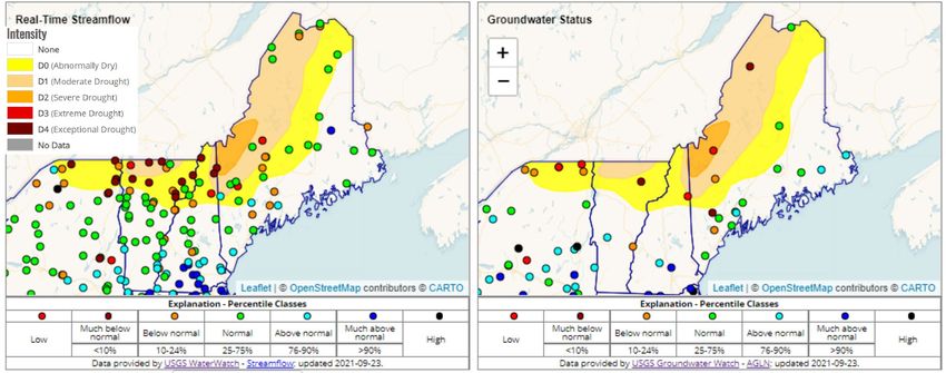
Figure 1: USGS maintains real time surface level water (left, shown here overlain on US Drought Monitor Map) and groundwater
information (right). U.S. Drought Monitor: https://droughtmonitor.unl.edu; Water Watch: waterwatch.usgs.gov; Ground Water
Watch: groundwaterwatch.usgs.gov, Northeast DEWS Dashboard: http://nedews.nrcc.cornell.edu/
In response to persistent drought, the Maine Emergency Management Agency
publishes these biweekly Drought Reports. Previous reports are available here:
https://www.maine.gov/mema/hazards/drought-task-force.
This report summarizes information presented by Task Force members on current hydrologic and
drought conditions as of this date. Task Force partners will report any drought-related impacts for which
they are notified. Drought can occur over many different scales and timelines. The Maine Drought
Task Force reports primarily on long term dry weather and drought conditions as indicated by
the U.S. drought monitor, with the recognition that many drought-related impacts to specific
sectors may be more sensitive to shorter-term fluctuations in dry and wet weather. No single
measure can adequately address all manifestations and sensitivities to drought, so please refer
to our sector-specific monitoring information below.
-1-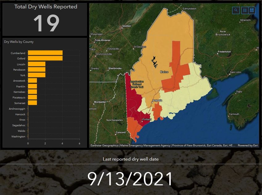
Drought Task Force                                                                         September 23, 2021

Current Hydrologic Conditions:

Stream Flows
Monitoring stations on the Androscoggin River, and its tributaries, consistently indicate flows in the
lowest 10% of all data collected at those stations. This basin did not show the slight improvement seen
in the Kennebec and Penobscot basins since the Maine Drought Task Force last met. The percentage
of long term stations in the below normal categories has increased slightly over the last two weeks, but
still represents only 20% of those stations. Earlier in the summer, nearly all of these long term stations
were in a below normal category.

Ground Water
The lowest groundwater levels in the state remain along the New Hampshire border up to the border
with Canada in western/northwestern Maine. This includes Sanford, Oxford Hills, Eustis and Clayton
Lake. While most of these monitoring wells have not shown recharge this summer, there is some
improvement indicated in the Sanford monitoring well. Other wells in Maine remain in the normal to
above normal range.

Weather Outlook:

At the onset of the
forecast period an
area of low pressure
will be traversing east
out of New York with
a slow moving cold
front that will move
into Maine on Friday.
Moisture ahead of
this feature will be
high which will
support notable
widespread rainfall
with most areas
expected to receive
over 0.75”, with
higher amounts likely
                            Figure 2: 7-day rainfall forecast.
in the drought
stricken mountain                                                  Table 1: Precipitation departures thru 9/20
regions. The front will slow to a crawl and may still be over      Location       Departure       Departure,
eastern Maine on Sunday, continuing rain throughout the                           for             year-to-date
weekend. The current 7 day rainfall forecast shows 0.75” to                       September
2.5” for the state (Figure 2), with heavier rainfall expected in   Caribou        -1.15”          -2.47
the mountains and lakes regions. Flooding is not expected,         Bangor         -1.28”          -2.14
but a much welcome soaking rain likely for the region.             Millinocket    -1.03”          -4.46
                                                                   Portland       -1.38”          -2.92
The 6-10 day outlooks slightly favors above normal rainfall        Rangeley       M               M
for the state through the end of September (Figure 3). The temperature outlook shows moderate
confidence for above normal temperatures across most of the state, primarily due to above normal low
temperatures. The trend favors above normal rainfall. The current tropical outlook does not indicate
any storms affecting the eastern U.S. for the next two weeks. However, the influence of tropical activity
is a low confidence forecast and adds more uncertainty to the outlook forecast in general. Attention
                                                      -2-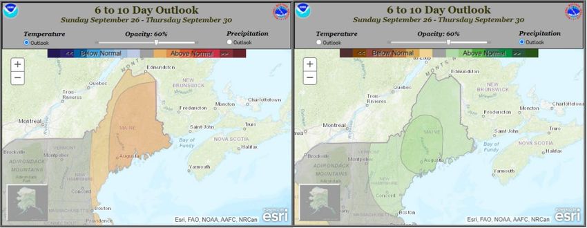
Drought Task Force                                                                     September 23, 2021

should continue to be paid to the tropical Atlantic where storms are currently developing and conditions
favor above normal activity through the season.

 Figure 3: 6-10 day temperature (left) and precipitation (right) outlooks.

Headwater Storage Levels

Storage conditions in the major river basins as reported by the hydropower companies this week are as
follows:

   •    Presumpscot River – The water level at Sebago Lake is currently 263.94 feet, a decrease of 1”
        for the week. Flow from Sebago Lake remains at 270 cfs as Sappi continues to closely monitor
        conditions and consult with the resource agencies regarding increasing flow to maintain good
        dissolved oxygen concentrations downstream of the dam.

   •    Androscoggin River – Storage conditions in the upper Androscoggin River basin are reported
        to be 55.3% full this week, which is 12.2% below the long-term average for this time of the year.
        Both water levels and flows are currently stable. River managers are planning a demonstration
        flow with Maine’s Department of Inland Fisheries and Wildlife that is expected to have a short-
        term impact on water levels and flows in the Richardson Lake drainage.

   •    Kennebec River – Storage conditions in the upper Kennebec River basin are reported to be
        67.7% full, just 1.7% below the long-term average for this time of the year . FLow has been
        increased at Brassua and Moosehead lakes.

   •    Penobscot River – Total storage in the west branch of the Penobscot River remains slightly
        below the long-term average for this time of the year and natural inflows remain below average
        and below the lowest inflows recorded. Storage conditions at Ripogenus remain well below the
        long-term average and continue to drop as water stored there is flowed downstream to North
        Twin, where water levels remain stable. Water levels in the four small storage reservoirs
        continue to decline.

   •    Union River – Storage conditions continue to improve in the Union River basin (at Graham
        Lake) and are 3.36 feet higher than the long term average for this time of the year as a result of
        changed operating conditions.

   •    St. Croix River – The west branch of the St. Croix River is reported to be 70.1% full at West
        Grand Lake, and the Vanceboro impoundment (representing flow from the east branch) is
        reportedly 75.0% full. The Grand Falls Flowage is 83.8% full and is flowing 1,606 cfs. The river
        flow at Baring is 1,620 cfs. River managers are working to flow water out of the impoundments

                                                             -3-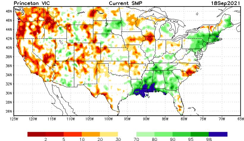
Drought Task Force                                                                              September 23, 2021
       to achieve minimum lake elevations at East Grand Lake and West Grand Lake in order to
       protect Lake Trout spawning habitat and egg incubation.

Drought Impact Sectors

Public Water Systems
The Maine CDC Drinking Water Program (DWP) has not received any new reports of water quantity
issues from public water systems (PWS) since mid-August. Some PWSs have standing voluntary water
conservation orders. The South Berwick Water District and the Stonington Water Company have issued
emergency mandatory water use restrictions that are in effect into the fall.

Dry Wells
Nineteen dry private wells have
been reported in ten counties
(Figure 4). At this time most reports
are for dug wells, and 89% of all
reported wells are for residential
use. Maine homeowners with dry
wells are encouraged to report this
information to the Dry Well Survey:
bit.ly/3iU6hvu.

For low income homeowners
requiring assistance with dry
private wells (including drilling a
well deeper, drilling a new well,
laying pipes to the home,
associated labor costs, etc.) please
refer to the USDA Single Family
Housing Repair Program or the
Maine State Housing Authority           Figure 4: Dry Well Survey Dashboard (bit.ly/3iU6hvu).
Home Repair Program.

Wildfire conditions
Since January 1st, we have had 622 wildfires in Maine covering 372 acres. In the last 30 days, 25
wildfires have burned 5.8 acres. In the last 7 days, 5 fires have burned 0.6 acres. The largest fire cause
in the last 30 days has been equipment, accounting for 32% of our fires. As we move into fall, it is
important to understand that fires, and sometimes large damaging fires, are still a threat. Fall brings leaf
litter, reopened canopies for solar heating, drier fuels through lower relative humidity, as well as higher
winds. When viewing our Daily Wildfire Danger Report, remember that it is a one day forecast which is
calculated using minimal data from the previous weather. As always, we should expect a rise in fire
activity when we progress through another prolonged drying trend and the fuels become more available
for ignition.

Agricultural and Forest Conditions
Agricultural conditions are reasonably good as we approach the end of the growing season. Potato
harvest looks good for quality and quantity, with no major water use conflicts noted. Other crops are
looking good, with the diminishing drought reducing the irrigation workload on producers

The USDA Farm Service Agency has received a Secretarial Disaster Designation dated 8/13/2021 due
to the drought situation. This designation opens up the Livestock Forage Disaster Program (LFP) and
Emergency Assistance for Livestock, Honeybees, and Farm-Raised Fish Program (ELAP) for the
designated counties of Oxford. Franklin, Somerset, and Piscataquis. Additionally, Aroostook,
Penobscot, Androscoggin, Cumberland, York, Kennebec, and Waldo Counties are included under the
disaster designation as “contiguous counties.” Secretarial Disaster Designations immediately trigger
                                                      -4-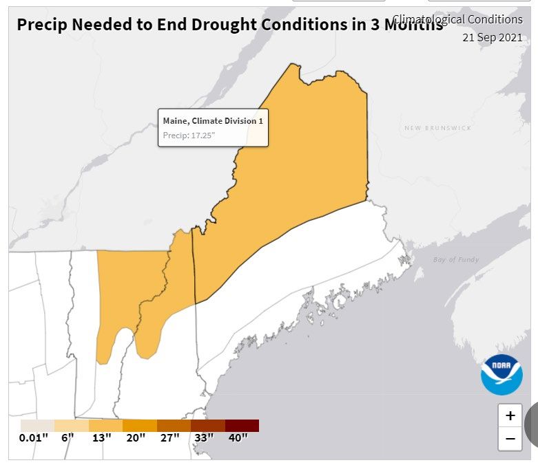
Drought Task Force                                                                              September 23, 2021
the availability of low-interest FSA
Emergency (EM) loans to eligible
producers in all primary and
contiguous counties. Applications
for an EM loan will be accepted for
8 months from the date of the
disaster designation.In addition the
Emergency Loan Program and
Disaster Set-Aside Loan Program
are now available for the
designated counties as well as the
contiguous counties. Refer to
www.farmers.gov/protection-
recovery/drought for more
information.
                                        Figure 5: Current soil variable infiltration capacity:
                                        https://www.cpc.ncep.noaa.gov/products/Drought/Monitoring/smp.shtml#
Governor Janet Mills is
encouraging small businesses in
several Maine counties to apply for newly available Economic Injury Disaster Loans (EIDL) through the
U.S. Small Business Administration (SBA). Farm-related entities in Androscoggin, Aroostook, Franklin,
Kennebec, Oxford, Penobscot, Piscataquis, Somerset and Waldo counties that have suffered financial
losses as a result of the drought that began in Maine on June 22nd are eligible for low-interest loans
from the SBA.

Drought Outlook
A substantial amount of precipitation is needed to end
current dry conditions (Figure 6). In northern and western
Maine, 17.25 inches of rainfall, or 149.37% of normal
summer/fall precipitation, is required within the next three
months to return to normal conditions. These drought
conditions are now expected to improve in fall based on
NOAA NCEP Climate Prediction Center models
(go.usa.gov/3eZ73). The Task Force will continue to
monitor abnormally dry conditions in the state until
conditions broadly improve across Maine.

About this Report
                                                                   Figure 6: Rainfall required to end drought
Current information represents a “snapshot” of                 conditions. www.ncdc.noaa.gov/temp-and-
conditions throughout the state for the date of                precip/drought/recovery/current/wmp/end-rain/3
reporting. This report provides information on the
preliminary effects of the drought and more monitoring must be done to assess potential impacts if the
situation worsens. Many new factors will influence drought potential in Maine as the season
progresses. These factors will be monitored, and the Drought Task Force will monitor the situation until
warning indicators subside.

The Maine Drought Task Force is composed of representatives from major river basin management
operations, utility operators as well as state agencies and federal agencies. The Task Force is
convened when necessary based on drought threat, and members will stay in close communication
until the dry conditions subside.

                                                     -5-
Drought Task Force September 23, 2021
Information Resources
Please refer to these sources for more information on current water conditions:
• Maine Drought Task Force website, with links to other reports and drought monitoring resources:
https://www.maine.gov/mema/hazards/drought-task-force
• Drought.gov site for the State of Maine: https://www.drought.gov/states/maine
• Northeast DEWS: http://nedews.nrcc.cornell.edu/
• National Integrated Drought Information System: https://www.drought.gov/current-conditions
• U.S. Drought Monitor: https://droughtmonitor.unl.edu/CurrentMap/StateDroughtMonitor.aspx?ME
• Well monitor data: https://groundwaterwatch.usgs.gov/StateMap.asp?sa=ME&sc=23
• Streamflow data: https://waterwatch.usgs.gov/?m=real&r=me
• Streamflow data aggregated by watershed: https://waterwatch.usgs.gov/index.php?m=dryw&r=me
• Maine Cooperative Snow Survey: https://www.maine.gov/dacf/mgs/hazards/snow_survey/
• NWS Gray short- and long-term forecasts:
https://forecast.weather.gov/product.php?site=NWS&issuedby=GYX&product=AFD&format=CI&version=
1&glossary=1&highlight=off
• NWS Caribou short- and long-term forecasts:
https://forecast.weather.gov/product.php?site=NWS&issuedby=CAR&product=AFD&format=CI&version=
1&glossary=1&highlight=off
• USDA farm assistance and loan programs: https://www.farmers.gov/protection-recovery/drought
• CoCoRaHS local volunteer weather condition monitoring:
https://www.cocorahs.org/maps/conditionmonitoring/index.html
For additional information on specific aspects of this report, please contact:
Samuel Roy, Maine Emergency Management Drought preparedness and Samuel.roy@maine.gov
Agency mitigation
Nick Stasulis, USGS Streamflow, groundwater levels nstasuli@usgs.gov
Sarah Jamison/Donald Dumont, National Weather forecasting for southern gyx.hydro@noaa.gov
Weather Service, Gray, Maine and western Maine
Louise Fode/Joseph Hewitt, National Weather Weather forecasting for northern Louise.fode@noaa.gov
Service, Caribou, Maine and eastern Maine joseph.hewitt@noaa.gov
Kathy Howatt/Nathan Robbins/Christopher Dams/hydropower facilities and Kathy.howatt@maine.gov,
Sferra, Maine Dept. of Environmental Protection, river basin management Nathan.p.robbins@maine.gov
Bureau of Land Resources Christopher.Sferra@maine.gov
Susan Breau, Maine Drinking Water Program Public Water Utilities Susan.breau@maine.gov
Tom Gordon, Maine Dept. of Agriculture, Agricultural conditions Tom.Gordon@maine.gov
Conservation & Forestry
Sherry Hamel, USDA Farm Service Agency, Maine USDA Secretarial Disaster sherry.hamel@usda.gov
State Office Designation updates
Matt Gomes, Maine Forest Service Wildfire conditions Matt.gomes@maine.gov
-6-You can also read