AUSTRALIAN SEASONAL BUSHFIRE OUTLOOK: MARCH - MAY 2021 - Bushfire & Natural Hazards CRC
←
→
Page content transcription
If your browser does not render page correctly, please read the page content below
ISSUE 91 FEBRUARY 2021
TOPICS IN THIS EDITION | FIRE IMPACTS | FIRE SEVERITY | FIRE WEATHER

AUSTRALIAN SEASONAL BUSHFIRE
OUTLOOK: MARCH – MAY 2021
OVERVIEW
The influence of La Niña on Australia’s
climate has had a pronounced effect on fire
potential. Spring and summer have seen
average to above average rainfall across
much of the country, with the exceptions of
south east Queensland, south west Tasmania
and parts southern Western Australia.
  For autumn, below normal fire potential
can be expected in parts of Victoria and
far northern Queensland due to wet
conditions and damp vegetation and soils.
In contrast, dry conditions mean that
parts of central and southern Queensland
inland from the coast have been assessed                        Above normal fire potential
as above normal fire potential.                                 Normal fire potential
  Elsewhere, where the rain has fallen                          Below normal fire potential
in southern Australia, the risk of grass
                                                        Figure 1: AUSTRALIAN SEASONAL BUSHFIRE OUTLOOK: MARCH – MAY 2021. AREAS ARE BASED ON THE
and crop fires continues into autumn                    INTERIM BIOGEOGRAPHIC REGIONALISATION FOR AUSTRALIA AND OTHER GEOGRAPHICAL FEATURES.

due to strong vegetation growth. These
types of fires are fast moving and                   rainfall over these regions. It is important            Biodiversity, Conservation and Attractions
spread rapidly during strong winds.                  to remember that areas designated as                    Western Australia, and Bushfires NT.
  Prescribed burning during this Outlook             normal or below normal fire potential may
period is an important tool to reduce                experience fire – normal or below normal                OUTLOOK – AUTUMN 2021
bushfire risk. In many areas, prescribed             risk does not mean there is no risk.                    Bushfire potential depends on many factors.
burning opportunities may arise under                  The Australian Seasonal Bushfire Outlook:             The volume, location and timing of rainfall
appropriate weather conditions and                   March – May 2021 is developed by the                    are critically important when estimating
with enough local resources.                         Bushfire and Natural Hazards CRC, AFAC,                 vegetation (fuel) volumes and growth.
  The Australian Seasonal Bushfire Outlook:          the Bureau of Meteorology, Queensland                   The climate outlook for the next few months
March – May 2021 covers all states and               Fire and Emergency Services, the New                    is also a crucial factor. Of particular interest
territories. Fire management is a year-round         South Wales Rural Fire Service, ACT                     are the future tendencies of Pacific sea
process and the Outlook reflects the priorities      Emergency Services Agency, ACT Parks and                surface temperature associated with the
in each state and territory for the coming           Conservation Service, Country Fire Authority,           El Niño-Southern Oscillation, as well as the
months given the expected climate conditions.        Department of Environment, Land, Water                  Indian Ocean Dipole – major climate drivers
It provides information to assist fire authorities   and Planning Victoria, Tasmania Fire Service,           over Australia. Other less quantifiable factors,
in making strategic decisions such as resource       Country Fire Service, Department of Fire                such as the distribution and readiness of
planning and prescribed fire management              and Emergency Services and Department of                firefighting resources, are also considered.
to reduce the negative impacts of bushfire.
  Fire potential can vary greatly, even at
the smaller scale, between bordering states             DEFINITION
and territories. Each state and territory’s             Fire potential: The chance of a fire or number of fires occurring of such size, complexity
assessment takes into account different                 or other impact that requires resources (from both a pre-emptive management
land use types (such as agriculture, forestry,          and suppression capability) beyond the area in which it or they originate. Fire
public land) and vegetation types (forests,             potential depends on many factors including weather and climate, fuel abundance
grasslands, deserts). This in turn is influenced        and availability, recent fire history and firefighting resources available in an area.
by different forecasts for temperature and

              | All Hazard Notes are available at www.bnhcrc.com.au/hazardnotes                                                                                 1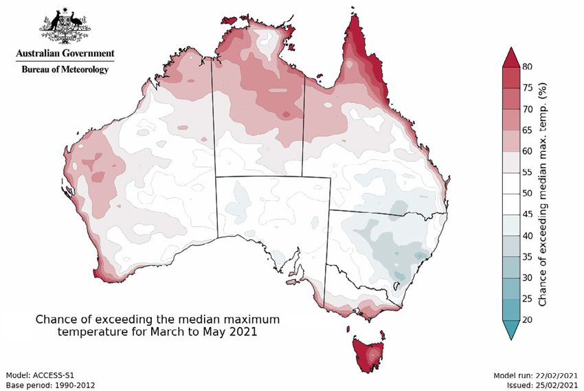
Figure 2: RAINFALL DECILES FEBRUARY 2020 TO JANUARY 2021. Figure 3: RAINFALL DECILES DECEMBER 2020 TO 24 FEBRUARY 2021.
Although La Niña has reached its peak, nationally on record. However, December since September 2020. La Niña typically
it is still expected to influence Australia’s 2020 and January 2021 were only slightly results in above average spring, summer
climate into autumn, with above average warmer than average, with above average and early autumn rainfall over much of
rainfall likely over much of the country. rainfall, especially in December (Australia’s eastern and northern Australia. Combined
For future updates on fire potential third wettest December on record), with other drivers that enhance rainfall,
during autumn, visit your rural fire keeping daytime temperatures cooler. including warmer than average waters to the
agency website. Rainfall so far in spring and summer 2020/21 north and west of Australia, parts of eastern
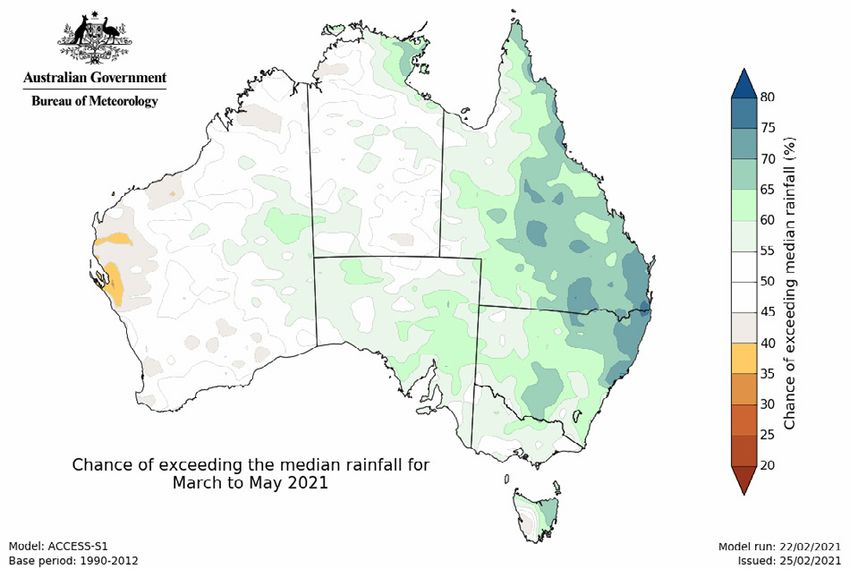
has eased the fire risk for large parts of eastern Australia are expected to experience wetter
RECENT CONDITIONS Australia, however southern South Australia than average conditions during autumn.
Seasonal fire conditions are a function of and south west WA have generally seen drier The rainfall outlook for March to May
fuel (vegetation) amount and dryness, and and warmer conditions in recent months. (Figure 4, page 3) shows that wetter than
recent rainfall and temperature patterns. Areas such as south west WA have seen average conditions are likely for eastern
Australia’s climate in spring and summer reduced rainfall over the multi-year timescale parts of Queensland, New South Wales and
2020/21 has been markedly different to and did not see the extended average to above Tasmania, with roughly an equal chance
2019. Since February 2020, rainfall has average rainfall that some regions in eastern of wetter or drier conditions elsewhere.
generally been average to above average Australia saw in 2020. More rainfall is needed Historical outlook accuracy for March to May
across much of the south east and north across many areas to fully recover from the is high across much of Australia, but generally
west of the country (see Figure 2, above). extreme dry of spring and summer 2019/20. moderate to low around far south west WA,
Rainfall during summer 2020/21 was above The tendency towards fire seasons with near the New South Wales-Queensland
average across parts of the south east, more frequently elevated fire dangers and for border and parts of south east NSW.
central, north and west of the country (see elevated fire danger to occur earlier and later Average maximum temperatures for
Figure 3, above right). In contrast, 2019 was in the season is a clear trend in Australia’s March to May are likely to be above average
Australia’s warmest and driest year on record. climate, reflecting reduced and/or less for Tasmania, parts of northern Australia
La Niña has been underway in the reliable cool season (April to October) rainfall and near-coastal parts of WA and Victoria.
tropical Pacific since September 2020 but is in southern parts and rising temperatures. There is no shift towards either above
expected to return to neutral (neither El Niño Fire season length and severity is increasing or below average temperatures for the
nor La Niña) in autumn. La Niña events across much of Australia as measured by remainder of the country (Figure 5, page
typically increase the likelihood of above- annual (July to June) indices of the Forest 4). Average minimum temperatures for the
average rainfall across much of Australia Fire Danger Index, with increases tending to same period are very likely to be above
during spring, and across much of eastern be greatest across inland eastern Australia the long-term average across much of
Australia during summer and early autumn. and coastal WA. For more details on the the country (Figure 6, page 4). Historical
Above average rainfall since August 2020 changes being observed, see the recently accuracy for March to May maximum
over some areas of eastern Australia has updated State of the Climate 2020 report temperature outlooks is high to very high
eased rainfall deficiencies. However, south from the Bureau of Meteorology and CSIRO. across the north of Australia. Elsewhere
west and southern Western Australia, and it is moderate, apart from much of SA
some of the southern agricultural areas CLIMATE OUTLOOK and inland southern WA, where it is low.
of South Australia, have received near- to The Bureau of Meteorology’s climate Historical minimum temperature outlook
below-average rainfall in the last 12 months. outlooks are based on the physics of accuracy is moderate to high across much
As a result, south west WA continues to the oceans, atmosphere, land and ice. of northern Australia, SA and the south
experience long-term rainfall deficiencies. They implicitly include all current climate east, including Tasmania, and low across
The long-term warming trend means that drivers, including long-term trends. much of southern Queensland and WA.
above-average temperatures now dominate The climate influences of 2020/21 are very The tropical cyclone season, which
most years, and recent months have different to those that led to the extreme officially started in November 2020 and runs
generally followed this pattern, despite La dry conditions in 2019. A La Niña event has until the end of April 2021, has to date been
Niña. Spring 2020 was the warmest spring been active in the tropical Pacific Ocean relatively subdued, though there have been
2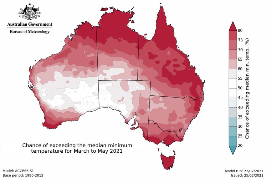
El Niño–Southern Oscillation conditions
                                                                                                           (neither El Niño nor La Niña) is expected
                                                                                                           to bring near average rainfall and daytime
                                                                                                           temperatures during March to May, however
                                                                                                           above average minimum temperatures are
                                                                                                           expected. Normal fire potential for autumn
                                                                                                           is expected as a result of these conditions.
                                                                                                             Given the return to neutral climate
                                                                                                           conditions, fire agencies and land managers
                                                                                                           will undertake prescribed burning when
                                                                                                           conditions allow. Given the amount of recent
                                                                                                           rainfall, grassland areas are likely to allow
                                                                                                           for prescribed burning sooner than forest
   Figure 4:   CHANCE OF EXCEEDING THE MEDIAN RAINFALL FOR MARCH TO MAY 2021.
                                                                                                           areas. ACT residents can monitor prescribed
                                                                                                           burns that are being planned and undertaken
a number of tropical lows that have brought              eventuated during the last outlook period.        through either the ACT Emergency Services
rainfall to some parts of northern Australia.            Although a number of hot and dry periods          Agency and ACT Parks and Conservation
However, March is historically the most active           occurred over summer, more recently               Service websites or Fires Near Me App.
month for tropical cyclone occurrence across             the usual pattern of curing or drying
the Australian region. While this may increase           of the grass that normally causes fire            VICTORIA
the chance of rainfall across northern                   danger to increase has been interrupted           Above average rainfall has occurred over
Australia, including inland regions, areas of            by the frequency and amount of rain.              much of Victoria during summer and daily
increased wind could potentially interact                  This rain has also led to continued growth.     maximum temperatures were below average
with any fires in the south of the country.              Although the rainfall outlook for the coming      across the south, but average across the
  Updates to climate forecasts, including                months suggests higher than average rainfall      north of the state. These conditions led to
forecasts of monthly, fortnightly and weekly             is possible for much of the state, depending      reduced fire activity in both grasslands and
outlooks and the outlook for the Indian                  on local conditions these high grass fuel         forests, with a cumulative area burnt of
Ocean Dipole and the El Niño–Southern                    loads may pose a risk during autumn.              6,800 ha to date compared to the 10 year
Oscillation will continue to be published                  The rainfall outlook, in combination with       annual average burnt per year of 252,026 ha.
at www.bom.gov.au/climate/ahead.                         warmer than average minimum temperatures            These conditions and the climate outlook
                                                         outlooks, may extend growing conditions           indicate lower bushfire potential for many
REGIONAL SUMMARIES                                       for grassland areas. This could lead to higher    parts of Victoria than is normal during autumn.
                                                         fuel loads heading into next fire season and      Below normal fire potential is expected in
QUEENSLAND                                               poses a particular risk to an early start to      wet forests and many foothill forests due to
Recent rainfall, particularly across northern            next season in grassland areas especially if      higher than normal soil moisture levels limiting
Queensland continues to improve fire risk                frosts occur during winter as this could result   the flammability of vegetation (fuels). These
conditions. With the continued rainfall in the           in high fuel loads more susceptible to fire.      soil moisture levels will likely persist due to
northern parts of the state, an increase in                Whilst the fire outlook on the balance          no strong changes to drier conditions.
growth in biomass is expected and is likely              of the forecast appears normal, there is            Opportunities for planned burning may be
to lead to lower than normal fire potential.             a need to monitor for unusual weather             currently limited in foothill forests due to high
  Lower than normal rainfall over the                    events (particularly windy conditions) that       soil moisture levels. However drier forests,
coastal areas from Rockhampton to south                  occasionally present during this period.          woodlands, heathlands and grassy woodlands
of Townsville may increase fire potential                  Traditionally in NSW the period March           may be more receptive to planned burning
through March to early April. Conditions                 to May sees a shift from the fire danger          compared to previous seasons. A return to
are likely to return to normal by May.                   period to a focus on hazard reduction             drier patterns would see planned burning
  For this autumn outlook period, fire                   burning. Conditions for the current outlook       opportunities in foothill forests open up.
potential across most of Queensland is                   period appear variable, with soil moisture        Warmer than average nights during autumn
expected to return to normal or below                    conditions for large areas in the eastern         may also expand windows for planned
normal conditions. The exception to this                 half of the state area wetter than average.       burning. District staff and planned burn teams
is some areas of the interior, to west and                 The grassland fuel state reflects               will monitor fuel conditions to safely and
central coastal areas, with above normal                 this situation with reports of grass              effectively conduct planned burn operations.
fire potential expected. Fire mitigation                 growth and low levels of curing (green
activities may be challenging and affected               grass). As conditions allow, NSW fire             TASMANIA
by the positive moisture outlook throughout              and land management agencies will                 The influence of La Niña during spring and
Queensland. These activities will be                     undertake hazard reduction burning.               summer has seen above normal rainfall across
dependent upon local weather conditions.                                                                   northern Tasmania, and below normal bushfire
                                                         ACT                                               activity across the state. The south west was
NEW SOUTH WALES                                          Due to the influence of La Niña, good rainfall    consistently drier than normal from July 2020
The expected increase to grass fuel                      has been received across the ACT during           to January 2021 but large amounts of rain
loads across the central west of the state               summer. The forecast return to neutral            during February have returned the soil dryness

                                                                                                                                                               3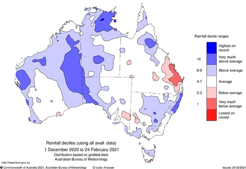
Figure 5: CHANCE OF EXCEEDING THE MEDIAN MAXIMUM                                Figure 6: CHANCE OF EXCEEDING THE MEDIAN MINIMUM
       TEMPERATURE FOR MARCH TO MAY 2021.                                              TEMPERATURE FOR MARCH TO MAY 2021.

    index to normal across large areas. Grassland         the median rainfall over the coming                 has resulted in an expectation of normal
    curing is proceeding across the state, with           months, early autumn is a nevertheless a            fire potential for the outlook period.
    most areas now over 80% cured. These                  climatologically dry time of year for SA. Until
    conditions mean that there is little likelihood of    sufficient rainfall is broadly received, which      NORTHERN TERRITORY
    sufficient drying occurring to allow landscape        typically will not occur until later in autumn,     With an active monsoon, root zone soil
    scale fires during autumn, although the grass         this risk will persist and an extension to the      moisture is above average for most of the
    fire risk remains in areas where the pasture          dates of the fire season in some fire ban           northern Top End including the Arnhem
    has not been harvested or grazed. Normal fire         districts may be required. This potentially         Coast, Darwin Coastal, Gulf Fall and
    potential is expected across the state for the        extended fire season would be fairly typical        Uplands, Gulf Coastal and Tiwi Coburg
    outlook period. Conditions for planned burning        of recent years and as such normal fire             regions. As a result, grass fuel growth
    during autumn are very promising, with                potential has been assessed for autumn.             continues with increasing moisture content.
    planned burning projected to start in March.                                                              Above average soil moisture levels extend
                                                          WESTERN AUSTRALIA                                   through most of the central belt from the
    SOUTH AUSTRALIA                                       Northern Western Australia has received             Sturt Plateau to the Tanami, Great Sandy
    Whilst some parts of South Australia have             a good amount of summer rainfall and                Desert, Burt Plain, Davenport Murchison
    received above average rainfall so far                this is reflected in the above average              and MacDonnell Ranges regions and grass
    this bushfire season, this rainfall has not           soil moisture content of the root zone.             fuel curing has been marginally lowered
    been widespread or significant enough                 Consequently, soil moisture may cause               as a result. While La Niña has passed its
    to negate a sustained risk of fire for most           a delay in planned burning activities               peak, rainfall is forecast to persist into the
    of the state. Furthermore, long-term                  for the Victoria Bonaparte, Ord Victoria            early dry season for parts of the Top End.
    rainfall deficiencies persist across most of          Plain, Central Kimberley, Northern                  Normal fire potential has been assessed
    the state, adding to the overall threat.              Kimberley and Dampierland bioregions.               for the whole of the Top End. Planned
      This risk is in line with conditions                  Summer 2020/21 saw WA affected by                 burning activities may be challenging until
    typically experienced during autumn                   a number of severe bushfires in the south           late May due to increased soil moisture
    and is characterised by short periods of              of the state. However the south west                levels and lower than average curing.
    heightened fire danger at regular intervals           received significant rainfall along the west           For central Australian regions, the fire
    that can support intense fire behaviour.              coast from a tropical low in early February         danger period commenced in mid-December
    Such spikes in fire danger created the                which has elevated soil and live woody              2020 and was revoked on 29 January 2021
    conditions experienced during summer                  vegetation moisture contents, particularly          following widespread rain. This rain increased
    at the Blackford fire at Lucindale and the            for the Geraldton sandplains, Swan Coastal          soil and fuel moisture content levels which
    Cherry Gardens fire in the Adelaide Hills.            Plain, Jarrah Forest and Warren bioregions.         reduced the fire risk. All regions in central
      While the current climate forecast                  This above average summer rainfall,                 Australia have been identified as having
    indicates an increased chance of exceeding            together with a neutral climate outlook,            normal fire potential through to May 2021.

    The Bushfire and Natural Hazards              Hazard Notes are prepared from               All material in this document, except as identified below,
    CRC is a national research                    available research at the time of            is licensed under the Creative Commons Attribution-Non-
    centre funded by the Australian               publication to encourage discussion          Commercial 4.0 International Licence.
    Government Cooperative Research               and debate. The contents of Hazard           Material not licensed under the Creative Commons licence:
    Centre Program. It was formed in              Notes do not necessarily represent the           •   Bushfire and Natural Hazards CRC logo
    2013 for an eight-year program                views, policies, practises or positions          •   All photographs.
    to undertake end-user focused                 of any of the individual agencies or         All rights are reserved in content not licenced under the
    research for Australia and                    organisations who are stakeholders of        Creative Commons licence. Permission must be sought
    New Zealand.                                  the Bushfire and Natural Hazards CRC.        from the copyright owner to use this material.

4                                                                                                                                         www.bnhcrc.com.au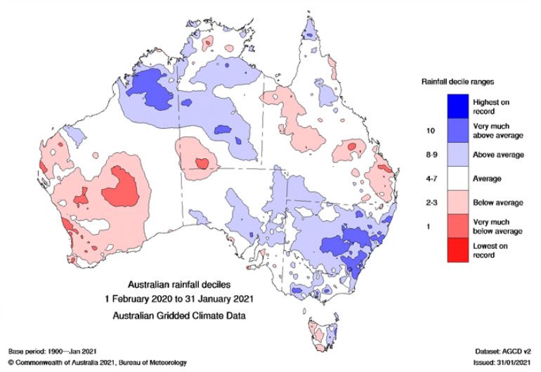
You can also read