SOUTHERN AUSTRALIA SEASONAL BUSHFIRE OUTLOOK 2018 - Bushfire & Natural ...
←
→
Page content transcription
If your browser does not render page correctly, please read the page content below
ISSUE 51 SEPTEMBER 2018
TOPICS IN THIS EDITION | FIRE IMPACTS | FIRE SEVERITY | FIRE WEATHER
SOUTHERN AUSTRALIA SEASONAL
BUSHFIRE OUTLOOK 2018
OVERVIEW
The Southern Australia Seasonal Bushfire
Outlook is used by fire authorities to make Above normal fire potential
strategic decisions on resource planning Normal fire potential
and prescribed fire management for the
upcoming fire season. At the 2018 Southern
Seasonal Bushfire Assessment Workshop
in August, the Outlook was assessed and
a range of broad climate factors were
considered. The map to the right shows
the bushfire outlook for southern Australia
through to the end of 2018. This map has
been combined with the outlook for the
northern Australia bushfire season, which
was released in July, to show the areas of fire
potential for all of Australia (see Hazard Note
49, July 2018).
ANTECEDENT CONDITIONS Above: AREAS BASED ON INTERIM BIOGEOGRAPHIC REGIONALISATION FOR AUSTRALIA AND OTHER GEOGRAPHICAL
FEATURES.
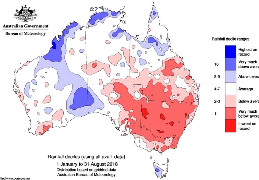
Most of eastern and parts of south west
Australia have experienced a dry 2018 to evaporation, further drying the landscape rising temperatures and below average
date (Figure 1, page 2). The focus of the dry and vegetation. rainfall during the cool season (April to
conditions has been New South Wales, where Dry and warm weather has seen poor October). Southern Australia has now
almost the entire state has experienced vegetation growth for most of southern experienced above average temperatures
rainfall in the lowest decile (driest 10 per cent Australia. The general landscape dryness in 22 consecutive years, with the last below
of recordings), representing serious to severe means that warm, windy conditions are average season back in 1995.
rainfall deficiencies. Rainfall deficiencies also likely to see elevated fire risk, and make an The combination of short and long-term
affect most of northern and eastern Victoria, early start to the fire weather season likely. rainfall deficits serves to increase the fire
parts of southern and central Queensland Countering this risk, the poor growth of grass risk in the coming spring and summer. A
and eastern South Australia. Across southern and annual plants means that vegetation shift towards below average rainfall first
Australia above average rainfall is limited to loads are reduced in drought affected areas. affected south west Australia around the
the arid regions of western South Australia Further north, low rainfall conditions since 1970s, and has largely dominated the south
and adjacent parts of Western Australia, as March mean that vegetation is dry with east since the mid-1990s. For south west
well as western areas of Tasmania. While very low greenness evident in satellite data, Australia and Victoria, 17 of the past 20
August has seen some rainfall in drought meaning that the northern fire season is well years have now seen below average cool
affected inland areas, this has fallen well underway. season rainfall, while the Murray-Darling
short of that required to remove the longer- Fire season severity is increasing across Basin has experienced below average rainfall
term deficiencies which remain extensive. southern Australia as measured by annual in 15 of the past 20 years. It is very likely
The combination of dry weather and the indices of the Forest Fire Danger Index. that Victoria and the Murray-Darling Basin
background warming trend has resulted in The increases are tending to be greatest will see a 2018 total which is substantially
much warmer than average temperatures. in inland eastern Australia and coastal below average, adding to this pattern. The
Daytime maximum temperatures have been Western Australia. For example, the combination of warming and drying has led
unusually warm in 2018, with a year-to-date Victorian annual Forest Fire Danger Index to extensive and historically unprecedented
maximum temperature anomaly of +1.36°C, has increased by about 50 per cent since landscape dryness across much of southern
the warmest on record (Figure 2, page 2). 1950, with particularly high values during the Australia.
High daytime temperatures add to the severe fire seasons of 2002/03, 2006/07, The El Niño–Southern Oscillation (ENSO)
impact of reduced rainfall, and act to increase 2008/09 and 2015/16. The increases reflect is currently neutral. However, the overall
| All Hazard Notes are available at www.bnhcrc.com.au/hazardnotes 1
Figure 1:    JANUARY TO AUGUST 2018 RAINFALL DECILES.                                   Figure 2:   JANUARY TO AUGUST 2018 MAXIMUM TEMPERATURE DECILES.

    pattern resembles the early stages of past                 in the south west, south east and much                 REGIONAL SUMMARIES
    El Niño events, with warmer than average                   of Queensland. This is particularly so for
    ocean temperatures in central parts of                     September, when large areas have a less than           QUEENSLAND
    the tropical Pacific, and above average                    35 per cent probability of exceeding median            While October 2017 saw record rainfall across
    temperatures in the ocean subsurface. The                  rainfall. In the arid interior and parts of the        the southern part of Queensland, summer
    Bureau’s ENSO Outlook remains at El Niño                   north west, probabilities are close to 50 per          was relatively dry. This changed during
    WATCH. El Niño WATCH means there is                        cent; however it is seasonally dry over these          autumn, which was the wettest autumn state
    approximately a 50 per cent chance of El                   regions at this time, so low rainfall totals are       wide since 2012. Much of this rain fell during
    Niño forming in 2018; about double the                     expected. Historical outlook accuracy for              March in central and southern Queensland.
    normal chance. International climate models                September to November is moderate to high              Locally, areas that missed this rain
    surveyed by the Bureau predict further                     over most of the country, except for the west          experienced their driest autumn in several
    warming of the tropical Pacific is likely as               of Western Australia, where accuracy is low            decades. It was hot too, with Queensland’s
    we move into spring. All models suggest El                 to very low.                                           summer being the second warmest on
    Niño thresholds are likely to be reached by                  The outlook for spring maximum                       record.
    the end of the year, though it is likely that a            temperatures favours above average                        These conditions have led to areas south
    developing event will be short lived. El Niño              daytime temperatures for nearly all of                 and west of Dirranbandi, Bollon, Boulia
    typically means below average rainfall in                  Australia. Probabilities are particularly              enduring one of the most severe droughts
    eastern and northern Australia, while daytime              high in northern and western areas where               in decades. As a result, almost all of inland
    temperatures are typically above average                   they exceed 80 per cent. Probabilities in              southern Queensland has very sparse
    over the southern two-thirds of Australia.                 the south east are typically in the range              vegetation and fuel loads. While this reduces
      The Indian Ocean Dipole (IOD) is neutral.                of 60 to 75 per cent (Figure 5, page 4),               the potential for high intensity grassfires it
    However, the ocean to the north west of                    implying that above average daytime                    should be noted that fully cured grass even
    Australia remains cooler than normal, which                temperatures are favoured. The outlook                 with low fuel loads can carry fast moving
    is likely contributing to suppressed rainfall              for minimum temperatures (not shown) is                fires in hot, dry and windy conditions.
    over southern and south east Australia in                  similar to that for maximum temperatures,                 Vegetation along the Coral Coast around
    recent months. Three of six international                  though the overall shift towards likely                Hervey Bay and Bundaberg, north to the
    climate models suggest a short-lived                       warmer than average temperatures is less               Capricornia around Rockhampton, has
    positive IOD event may develop. A positive                 strong. Historical accuracy for September              experienced below average rainfall over the
    IOD during spring typically reduces rainfall               to November maximum temperatures is                    past 12 months. This drying trend is forecast
    in central and southern Australia and can                  moderate to high for most of the country.              to continue through September and October,
    exacerbate any El Niño-driven rainfall                     Minimum temperature accuracy is moderate               with above normal fire potential expected.
    deficiencies.                                              for eastern Australia, the Top End, and parts             Further south, both the forest and
                                                               of central Australia. Elsewhere, accuracy is           grassy fuels around Toowoomba, north to
    CLIMATE OUTLOOK                                            either patchy or low to very low.                      Kingaroy, south to Warwick and Stanthorpe,
    The climate outlook for spring is mainly                     Taken as a whole, the current warmer and             east to Gatton and south to Boonah and
    influenced by the Pacific and Indian Oceans,               drier than average climate conditions and              Beaudesert have very much below average
    together with other factors including long-                the outlooks suggest that the southern fire            soil moisture. Fuel loads in these areas are
    term trends. As previously noted, the Pacific              season is likely to commence earlier than              above the long term average. With the
    and Indian Ocean are neutral, though the                   usual and be more active than normal.                  outlook for hotter, and average or dryer than
    development of an El Niño and positive IOD                   Updates to climate forecasts and the                 average conditions, there is little chance
    is possible.                                               outlook for the Indian Ocean Dipole and the            that the fuel availability will return to the
      The outlook for September and spring                     El Niño-Southern Oscillation will continue to          long term average during the bushfire
    rainfall (Figures 3 and 4, page 3) shows an                be published at www.bom.gov.au/climate/                season. Grassland curing rates are more
    increased likelihood of below average rainfall             ahead.                                                 advanced than normal for this time of year

2
Figure 3: THE OUTLOOK FOR SEPTEMBER RAINFALL. Figure 4: THE OUTLOOK FOR SPRING (SEPTEMBER TO NOVEMBER) RAINFALL.
following the very cold clear nights in these grassy vegetation is cured, it is below VICTORIA
areas during winter. With a drier and hotter average in quantity or load. With the chances Much of East Gippsland has experienced
outlook for September, and generally average of above median rainfall west of the divide two consecutive years of record low rainfall
conditions for the remainder of spring, these below 50 per cent to well below 50 per cent during autumn and winter. As a result,
areas are likely to have above normal fire in the next three months, the balance of this forests are significantly more flammable than
potential for the 2018 bushfire season. situation has resulted in an assessment of normal, due to an increase in dead material
Queensland’s fire season is already well normal fire season potential for grassland in the near surface and elevated fuels.
underway, with August seeing record fire areas west of the divide. It should be noted Unusually early bushfire activity occurred
danger in the south east. The amount that while grass load is reduced and therefore in East Gippsland during July and August,
and severity of fires was above normal the potential intensity of grass fires may highlighting the severe level of dryness in
in this area, with the Queensland Fire be reduced, highly cured grass creates the forests. These dry conditions are likely to be
and Emergency Services increasing its potential for grassfire to spread rapidly. exacerbated during spring and summer with
community engagement and preparedness the climate outlook for drier and warmer
levels around fire preparation. ACT conditions. These areas can expect above
Along with many parts of Australia, the ACT normal fire potential from August right
NEW SOUTH WALES has for some months experienced below through summer.
Weather conditions have been exceptionally average rainfall. As a result, there is severe Further north, the Great Divide and Alpine
dry over New South Wales during 2018, with soil dryness across the ACT, which could regions are experiencing good levels of
the Murray Darling Basin recording its driest reduce spring grass growth and dry out the streamflow and snowfall, with the spring
January-July since 1965 (over 50 years). This forests. The seasonal weather outlooks issued forecast for continuing average streamflow in
has allowed severe rainfall deficiencies to by the Bureau of Meteorology indicate there the Alpine region. As a result, normal bushfire
accumulate in many areas west of the Great will be insufficient rain in the coming months potential is expected across these regions.
Dividing Range, but also through the Greater to relieve the underlying dryness. In the west and central regions, normal
Sydney region. At the end of August, the Because of this dryness, there is an bushfire potential is also expected as rain has
Department of Primary Industries mapped expectation that grasslands and forests will kept soil moisture at relatively high levels,
nearly all of NSW being in some state of become flammable earlier than is typical. This but there is some uncertainty around how
drought, with 21 per cent classified as in resulted in the ACT bushfire season being much dryness may carry over from previous
intense drought, 49 per cent experiencing declared a month early, on 1 September. seasons, as well as how quickly warm and dry
drought conditions, and a further 30 per cent Nearby fire activity in NSW during August conditions expected in spring may increase
as drought affected. reinforces the need to be prepared early. flammability in forests. The far South West
Widespread significant soil moisture Large fires requiring regional-level bushfire region, extending to the Barwon Otway
deficit has resulted in an early start to the fire suppression operations can be expected. region, is currently experiencing above
danger period for many local government While lower than average grassland fuel loads average rainfall, which has led to saturation in
areas in NSW. Windy conditions in August can also be expected, grass fires could still the soil moisture profile. Current expectations
resulted in many significant bushfires in be a problem in rural and metropolitan areas are for average to above average pasture
forested areas up and down the east coast. due to the ongoing drought conditions. It is growth in south west and western Victoria.
With the short to medium-range climate too early to anticipate the chance of major The timing and severity of grass fires will
outlooks favouring warmer and drier than rain occurring prior to summer. depend strongly on rainfall patterns during
average conditions across much of the state, The community is advised to begin late summer – as a result, a normal fire
there is significant concern for the potential preparations for the coming bushfire season. season expected in these areas.
of an above normal fire season in forested A high level of preparedness will be needed North and North Western Victoria has
areas on and east of the Divide. to mitigate the elevated bushfire risks. experienced below average rainfall during
Reports of grassland fuel conditions west autumn and winter, resulting in reduced
of the divide have indicated that whilst cropping activity and pasture growth. These
3areas are likely to experience a normal fire
season. It should be noted that due to the
uncertainties in the longer term climate
outlook, areas of normal fire potential may
still experience unpredicted severe bushfire
activity during late summer.
TASMANIA
For the early part of Tasmania’s fire season,
most of the state has normal fire potential.
The western half of the state is very wet, and
only the strip between Orford and St Helens
on the east coast is drier than average. This
dry strip has above normal fire potential, and
this area may expand without significant rain
in the coming months. As in recent years,
Figure 5: THE OUTLOOK FOR SPRING (SEPTEMBER TO NOVEMBER) MAXIMUM TEMPERATURES.
increased fire activity will probably occur
in this dry strip before December and will grass, also have above normal fire potential. Swan Coastal Plain, Avon Wheatbelt, Jarrah
require considerable response efforts. The Without effective control mechanisms to limit Forest, and Warren regions.
fire season in the remainder of the state will the spread of buffel grass, the abundance of Despite good winter rainfall, the underlying
commence more normally, in late spring or fuel it creates could create an increased and and persistent deep root zone soil moisture
early summer, and provide good conditions ongoing risk. deficits along the Darling Range, south west
for planned burning. Despite average winter rainfall, the fuel corner, South Coast, Mallee and Esperance
growth and forecast dry conditions indicate Plains have resulted in the forest and
SOUTH AUSTRALIA that the potential for bushfire across the shrubland vegetation in these areas being
Large parts of South Australia have populated areas of the Mount Lofty Ranges subject to additional water stress. Above
experienced drier than average conditions remains. normal fire potential is expected in these
since the start of 2018. Late winter rains have The dry conditions in agricultural areas areas.
helped reduce the soil dryness indices in have resulted in less cropping activity, with Further north, cooler and wetter wet
some parts of the state, however, the rainfall South Australia forecast to record a decrease season conditions were experienced
has not been enough to overcome the total in areas planted and in yields from sown in parts of the Pilbara, Gascoyne and
moisture deficits in these areas. Rainfall from crops. This may reduce the risk of fires from Carnarvon regions, which contributed to
now will also promote vegetation growth agricultural activity in some areas. the accumulation of higher than average
before summer, which will increase the It is important to note that no forecast grass fuel loads. This has resulted in above
available fire fuels during the fire season. The models are indicating any likelihood of normal fire potential in these regions. The
current Bureau of Meteorology forecast is increased rainfall across South Australia, Gascoyne Coast missed the subtropical low
for dry conditions to persist through spring which means the fire danger season has the rain which travelled further to the east and
which may also erode any benefits from potential to commence early and finish late is experiencing a rainfall deficit. This has
recent rainfall. in parts of the state. Significant bushfires affected grass growth and therefore the
The recent El Niño watch also suggests have occurred in similar conditions, and region is expected to experience normal fire
that the dry spring conditions are likely to areas of normal fire potential can expect potential.
continue throughout summer. On the basis to experience dangerous bushfires as per a Parts of south eastern Western Australia
of the forecast dry conditions, and the normal South Australian fire season. received significant rain in the early part of
cumulative effects of the long term moisture the year, which is evident in the elevated
deficit, several areas have been identified as WESTERN AUSTRALIA surface soil moisture in some areas. This has
having above normal fire potential. Parts of As a result of bushfires in previous seasons, led to increased growth of the shrubs and
the Riverlands, Murraylands, and the Flinders and mitigation achieved by prescribed grasses in these areas. Due to this increased
Ranges are particularly dry, which means that burning, higher fuel loads in the forests and vegetation growth, and therefore expected
areas of scrub and woodland have increased shrublands across the Darling Range have fuel loads, above normal fire potential
fire potential. been fragmented into smaller parcels. This is expected in these parts of the Mallee,
Populated areas of the APY Lands, has resulted in the break up and reduction of Coolgardie, Nullarbor, Hampton and Great
particularly those parts infested with buffel above normal fire potential areas within the Victoria Desert regions.
The Bushfire and Natural Hazards CRC Hazard Notes are prepared from available All material in this document, except as identified below,
is a national research centre funded by research at the time of publication to encourage is licensed under the Creative Commons Attribution-
the Australian Government Cooperative discussion and debate. The contents of Hazard Non-Commercial 4.0 International Licence.
Research Centre Program. It was formed in Notes do not necessarily represent the views, Material not licensed under the Creative Commons licence:
2013 for an eight-year program to undertake policies, practises or positions of any of the • Bushfire and Natural Hazards CRC logo
end-user focused research for Australia and individual agencies or organisations who are • All photographs.
New Zealand. stakeholders of the Bushfire and Natural Hazards All rights are reserved in content not licenced under the Creative
CRC. Commons licence. Permission must be sought from the copyright owner
to use this material.
4 www.bnhcrc.com.auYou can also read