Current Watches and Warnings - Aon
←
→
Page content transcription
If your browser does not render page correctly, please read the page content below
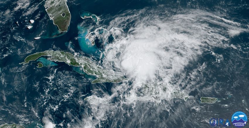
Current Watches and Warnings
A Hurricane Warning is in effect for the northwestern Bahamas including Andros Island, New
Providence, Eleuthera, Abacos Islands, Berry Islands, Grand Bahamas Island, and Bimini; southeastern
Bahamas including the Acklins, Crooked Island, Long Cay, the Inaguas, Mayaguana, and the Ragged
Islands; Central Bahamas, including Cat Island, the Exumas, Long Island, Rum Cay, and San Salvador
A Hurricane Watch is in effect from north of Deerfield Beach to the Volusia-Brevard County Line, Florida
A Tropical Storm Warning is in effect for the Turks and Caicos Islands; north of Ocean Reef northward
to Sebastian Inlet; Lake Okeechobee

Current Details from the National Hurricane Center (NHC)
COORDINATES: 21.7° north, 74.5° west
LOCATION: 365 miles (585 kilometers) south-southeast of Great Abaco Island (Bahamas)
MOVEMENT: northwest at 16 mph (26 kph)
WINDS: 75 mph (120 kph) with gusts to 90 mph (150 kph)
RADIUS OF TROPICAL STORM-FORCE WINDS: 205 miles (335 kilometers)
RADIUS OF HURRICANE-FORCE WINDS: 35 miles (55 kilometers)
MINIMUM CENTRAL PRESSURE: 992 millibars
SAFFIR-SIMPSON SCALE RANKING*: Category 1

24-HOUR LANDFALL POTENTIAL: HIGH (Bahamas)

Latest Satellite Picture

Source: NOAA; NASA; Colorado State University (RAAMB)
Discussion
Hurricane Isaías, located approximately 365 miles (585 kilometers) south-southeast of Great Abaco
Island (Bahamas), is currently tracking northwest at 16 mph (26 kph). After a brief hiatus of new
thunderstorm activity earlier today, there has since been a burst of new convection near the previously
exposed low-level center of circulation. Dry air downsloping off Hispaniola had previously wrapped into
the center that partially eroded the inner-core convection. However, an influx of moisture from the
southwest moving through the Windward Passage appears to be fueling the recent increase in
thunderstorm activity. The upper-level outflow has improved in the western semicircle but still remains
restricted due to some southwesterly vertical wind shear. The NHC has slightly lowered the initial intensity
to 75 mph (120 kph) based on most recent aircraft data, and the minimum central pressure has risen to
992 millibars. Isaías remains a Category 1 hurricane.

Isaías is continuing on a steady northwestward motion, and this is expected to continue for the next 36
hours as the hurricane rounds the southwestern periphery of the Bermuda High. A gradual turn to the
north-northwest and north is expected in the next two days or so as a break in a ridge of high pressure
currently in the Central U.S. will occur as a trough digs into the Southeast. The timing and strength of this
trough will determine how far west Isaías moves before the hurricane turns northward. One cluster of
computer models (including the U.S. GFS) has shifted westward closer to the Florida coast, which is
similar to the westward shift seen in the most recent European (ECMWF) model run. By 72 hours, the
hurricane is forecast to begin accelerating northeastward, possibly passing over eastern North Carolina
by Day 4 and across eastern New England on Day 5. Because of the westward shift in the latest model
guidance, the new NHC forecast track has also been shifted farther west closer to the southeastern U.S.
coast, and lies a little to the west of the model consensus. The westward shift in the track forecast has
required the NHC issuance of a Hurricane Watch for portions of the Florida east coast.

Although some slight weakening has occurred, radar data from the aircraft and the Bahamas radar
indicate about a partial eyewall has formed in the northeastern semicircle, which is an indication that the
cyclone is trying to reorganize. As a result, strengthening is still expected during the next day or so,
especially tonight and Saturday morning during the convective maximum period when the hurricane will
be moving over the Gulf Stream where sea surface temperatures remain very warm and vertical wind
shear is reasonably low. Increasing southwesterly shear could cause a gradual decrease in intensity over
the weekend. The new official NHC intensity forecast is similar to the previous advisory, and is a little
above the available model guidance.

Key Messages from the National Hurricane Center

1. Isaías will produce heavy rains and potentially life-threatening flash flooding and mudslides across the
Dominican Republic, northern Haiti, Turks and Caicos, and the Bahamas. Heavy rains associated with
Isaías may begin to affect south and east-central Florida late Friday night, and the eastern Carolinas by
early next week, potentially resulting in isolated flash and urban flooding, especially in low-lying and
poorly drained areas. Isolated minor river flooding is possible in the Carolinas early next week.

2. Hurricane conditions and dangerous storm surge are expected in portions of the Bahamas today and
Saturday, and Hurricane Warnings are in effect. Preparations to protect life and property should be
rushed to completion.

Cat Alert: Hurricane Isaías                                                                                   2
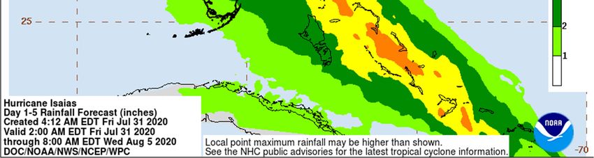
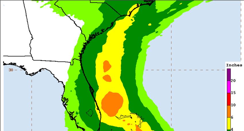
3. Tropical storm conditions are expected with hurricane conditions possible along portions of the Florida
east coast beginning Saturday, and a Tropical Storm Warning and Hurricane Watch are in effect. Storm
surge watches or warnings could be needed for part of this area this afternoon.

4. There is a risk of impacts from winds, heavy rainfall, and storm surge beginning late this weekend
along the northeastern Florida coast and spreading northward along the remainder of the U.S. east coast
through early next week. Interests along the entire U.S. east coast should monitor the progress of Isaías
and updates to the forecast.

Additional Information

STORM SURGE: A dangerous storm surge will raise water levels by as much as 3 to 5 feet above
normal tide levels in areas of onshore winds in the Bahamas.

WIND: Tropical storm conditions will continue across portions of the Turks and Caicos this morning.
Hurricane conditions in the southeastern Bahamas will spread northwestward into the central and
northwestern Bahamas tonight and into Saturday.

Tropical storm conditions are expected in the warning area in Florida beginning Saturday. Hurricane
conditions are possible in the Hurricane Watch area beginning Saturday night and continuing into
Sunday.

RAINFALL: Isaías is expected to produce the following rain accumulations:

Dominican Republic and northern Haiti: 4 to 8 inches, with isolated maximum totals of 12 inches
Bahamas, Turks and Caicos: 4 to 8 inches
Cuba: 1 to 2 inches, with isolated maximum totals of 4 inches

These rainfall amounts will lead to life-threatening flash flooding and mudslides, as well as river flooding.
Urban and small stream flooding is expected for the U.S. Virgin Islands and Hispaniola.

From Friday night through Monday:

South Florida into east-Central Florida: 2 to 4 inches, with isolated maximum totals of 6 inches

These rainfall amounts could result in isolated flash and urban flooding, especially in low-lying and poorly
drained areas.

Heavy rains associated with Isaías may begin to affect the eastern Carolinas by early next week. This
rain could result in isolated flash and urban flooding, especially in low-lying and poorly drained areas, as
well as isolated minor river flooding.

SURF: Swells generated by Isaías are affecting portions of Hispaniola, eastern Cuba, the Turks and
Caicos, and the southeastern and central Bahamas. These swells will spread into the central and
northwestern Bahamas later today and along the east coast of Florida on Saturday. These swells are
likely to cause life-threatening surf and rip current conditions.

Cat Alert: Hurricane Isaías                                                                                     3
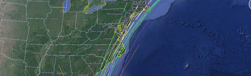
National Hurricane Center (NHC) Forecast

Cat Alert: Hurricane Isaías                4
Most Likely Arrival Time of Tropical Storm-Force Winds

Cat Alert: Hurricane Isaías                              5
National Hurricane Center: Wind Speed Probabilities
Tropical Storm-Force Wind Probabilities (≥40 mph (65 kph))

Cat Alert: Hurricane Isaías                                  6
Wind Probabilities (≥60 mph (95 kph))

Cat Alert: Hurricane Isaías             7
Hurricane-Force Wind Probabilities (≥75 mph (120 kph))

Cat Alert: Hurricane Isaías                              8
Weather Prediction Center: Rainfall Forecast

Cat Alert: Hurricane Isaías                    9
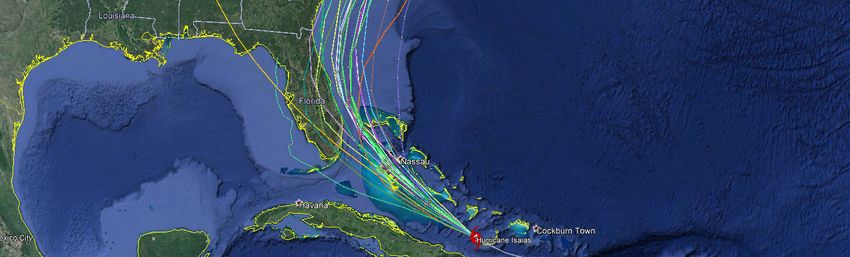
Current ‘Spaghetti’ Model Output Data

Source: NHC

Additional Information and Update Schedule
Wind intensity forecasts and forecast track information can be found via the National Hurricane Center at
www.nhc.noaa.gov

NEXT CAT ALERT: Saturday morning after 10:00 AM Central Time (15:00 UTC).

Cat Alert: Hurricane Isaías                                                                             10
*Tropical Cyclone Intensity Classifications for Global Basins
WIND SPEED BASINS AND MONITORING BUREAU
NE
NW NW SW Australi SW North
Pacific,
Pacific Pacific Pacific a Indian Indian
Atlantic
KTS1 MPH1 KPH1 Joint
Fiji India
National Typhoon Japan Bureau Of
Meteorologica Meteo-France Meteorologica
Hurricane Warning Meteorological Meteorology
l Service (MF) l Department
Center (NHC) Center Agency (JMA) (BOM)
(FMS) (IMD)
(JTWC)
Tropical Tropical Tropical
Tropical Tropical Tropical Deep
30 35 55 Depressio Depressio Depressio
Depression Depression Low Depression
n n n
35 40 65
Cat. 1 Cat. 1 Moderate
Tropical Cyclonic
40 45 75 Tropical Tropical Tropical
Storm Storm
Cyclone Cyclone Storm
45 50 85
Tropical Tropical
Storm Storm
50 60 95
Severe Cat. 2 Cat. 2 Severe Severe
55 65 100 Tropical Tropical Tropical Tropical Cyclonic
Storm Cyclone Cyclone Storm Storm
60 70 110
65 75 120
70 80 130
Cat. 1 Cat. 3 Cat. 3
Hurricane Severe Severe Tropical
75 85 140
Tropical Tropical Cyclone
Cyclone Cyclone
80 90 150
85 100 160
Very
Cat. 2 Severe
90 105 170
Hurricane Cyclonic
Cat. 4 Cat. 4 Storm
95 110 175 Typhoon
Severe Severe
Tropical Tropical
100 115 185 Intense
Cyclone Cyclone
Tropical
105 120 195 Cat. 3 Typhoon Cyclone
Major
110 125 205 Hurricane
115 130 210
120 140 220
Cat. 5 Cat. 5
125 145 230 Cat. 4
Severe Severe
Major
Tropical Tropical Very
130 150 240 Hurricane Super
Cyclone Cyclone Intense
Cyclonic
Tropical
135 155 250 Storm
Super Cyclone
Typhoon
140 160 260 Cat. 5
Major
>140 >160 >260 Hurricane
Cat Alert: Hurricane Isaías 11About Aon Aon plc (NYSE:AON) is a leading global professional services firm providing a broad range of risk, retirement and health solutions. Our 50,000 colleagues in 120 countries empower results for clients by using proprietary data and analytics to deliver insights that reduce volatility and improve performance. © Aon plc 2020. All rights reserved. The information contained herein and the statements expressed are of a general nature and are not intended to address the circumstances of any particular individual or entity. Although we endeavor to provide accurate and timely information and use sources we consider reliable, there can be no guarantee that such information is accurate as of the date it is received or that it will continue to be accurate in the future. No one should act on such information without appropriate professional advice after a thorough examination of the particular situation. Copyright © by Impact Forecasting® No claim to original government works. The text and graphics of this publication are provided for informational purposes only. While Impact Forecasting® has tried to provide accurate and timely information, inadvertent technical inaccuracies and typographical errors may exist, and Impact Forecasting® does not warrant that the information is accurate, complete or current. The data presented at this site is intended to convey only general information on current natural perils and must not be used to make life-or-death decisions or decisions relating to the protection of property, as the data may not be accurate. Please listen to official information sources for current storm information. This data has no official status and should not be used for emergency response decision-making under any circumstances. Cat Alerts use publicly available data from the internet and other sources. Impact Forecasting® summarizes this publicly available information for the convenience of those individuals who have contacted Impact Forecasting® and expressed an interest in natural catastrophes of various types. To find out more about Impact Forecasting or to sign up for the Cat Reports, visit Impact Forecasting’s webpage at impactforecasting.com. Copyright © by Aon plc. All rights reserved. No part of this document may be reproduced, stored in a retrieval system, or transmitted in any form or by any means, electronic, mechanical, photocopying, recording or otherwise. Impact Forecasting® is a wholly owned subsidiary of Aon plc. Cat Alert: Hurricane Isaías 12
You can also read