COMPREHENSIVE SUMMARY - SC.gov
←
→
Page content transcription
If your browser does not render page correctly, please read the page content below
SC
                              HURRICANES
                              COMPREHENSIVE
                              SUMMARY
                              LAST UPDATED: MARCH 2020

SOUTH CAROLINA STATE
CLIMATOLOGY OFFICE
Dr. Hope Mizzell, State Climatologist: MizzellH @ dnr. sc. gov
Melissa Grffin, Assistant State Climatologist:
GriffinM@dnr.sc.gov
Mark Malsick, Severe Weather Liaison: MalsickM@dnr. sc.gov
Leah Blackwood, Climatology Research Intern: BlackwoodL@dnr.sc. gov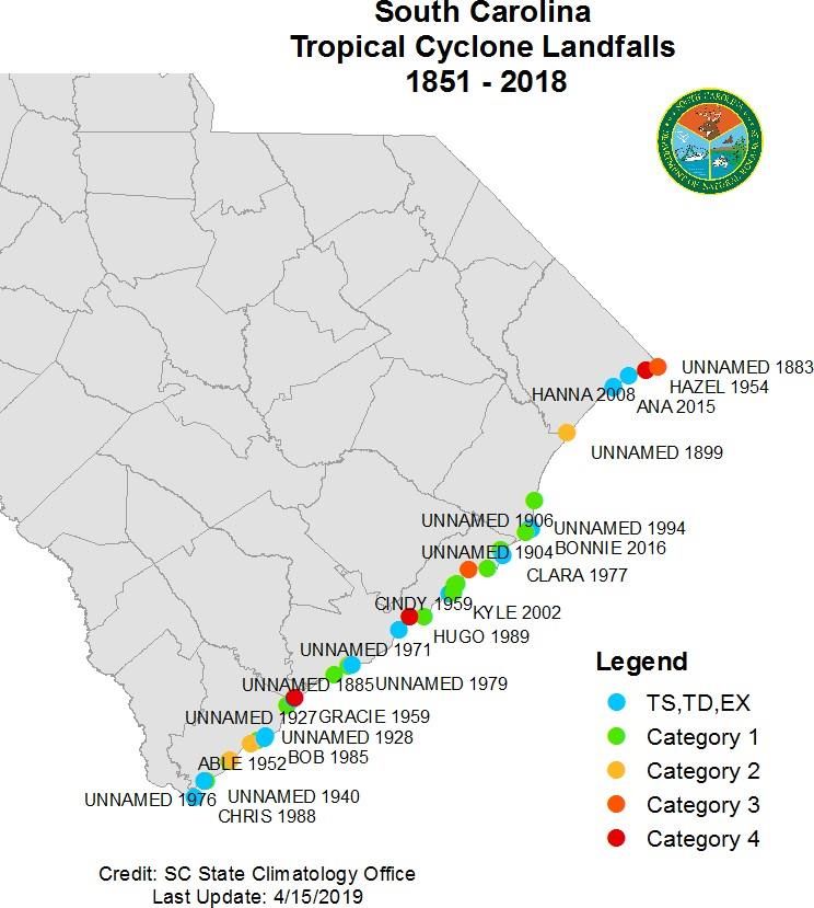
SOUTH CAROLINA                              *based on
                                                1851 - 2019

    BY THE NUMBERS                              period of
                                                record

                        THE BREAKDOWN:
         247      SYSTEMS HAVE IMPACTED S C

         130      HAVE TRACKED INTO THE STATE

          59      WERE CATEGORY 1 OR GREATER

          41      MADE DIRECT LA N DFA LL O N COA ST

                  MAJOR (CAT 3+) LA N DFA LLS
           4
        23.68"
S C RAINFALL R ECO R D FROM
   A TROPICAL C YC LO N E -
HURRICANE F LO R E N C E 2018

         79.7%
    C H A N C E OF BEING
 IMPACTED BY A TROPICAL
   SYSTEM EACH YEAR

                                                    47
                                          TO R N A D O ES CAUSED
                                            BY THE PASSING
                                              REMNANTS OF
                                          HURRICANE FRANCES
                                                  IN 2004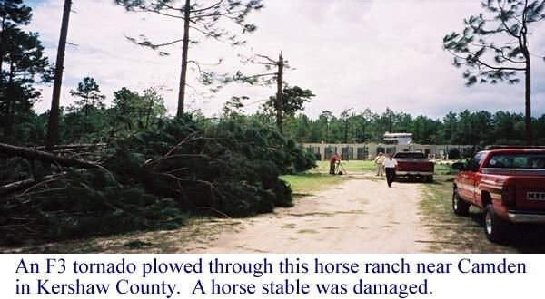
SOUTH CAROLINA *based on
1851 - 2019
BY THE NUMBERS period of
record
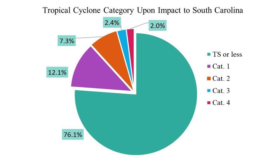
188 TROPICAL STOR M S (OR LESS)
30 CAT. 1 H U R R ICA N ES
18 CAT. 2 H U R R ICA N ES
6 CAT. 3 H U R R ICA N ES
5 CAT. 4 H U R R ICA N ES
0 CAT. 5 H U R R ICA N ES
SEASONAL RECORDS BY CATEGORY
EARLIEST LATEST
CATEGORY 4
August 26, 1958 October 15, 1954
CATEGORY 3
August 18, 1879 October 13, 1893
CATEGORY 2
July 14, 1916 October 31, 1899
CATEGORY 1
October 20, 1853
May 27, 1908 and 1906
TROPICAL STORM
February 3, 1952 December 2, 1925
L AN D FAL L
May 7, 2015 October 31, 1899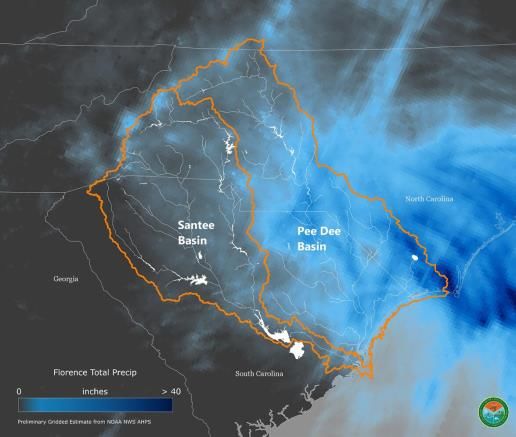
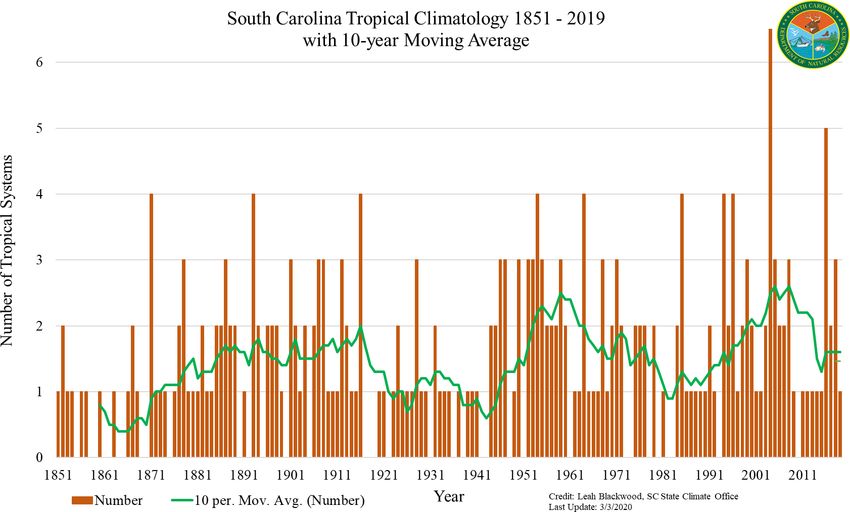
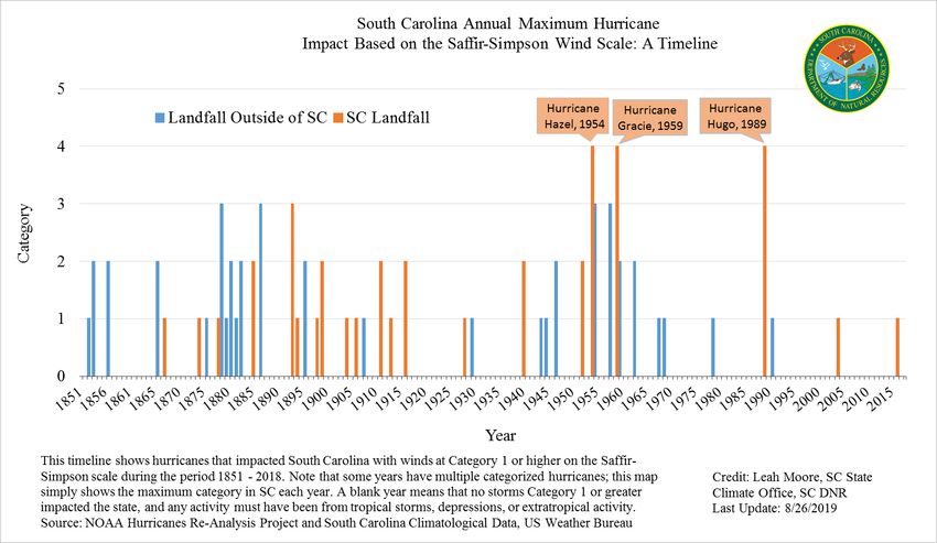
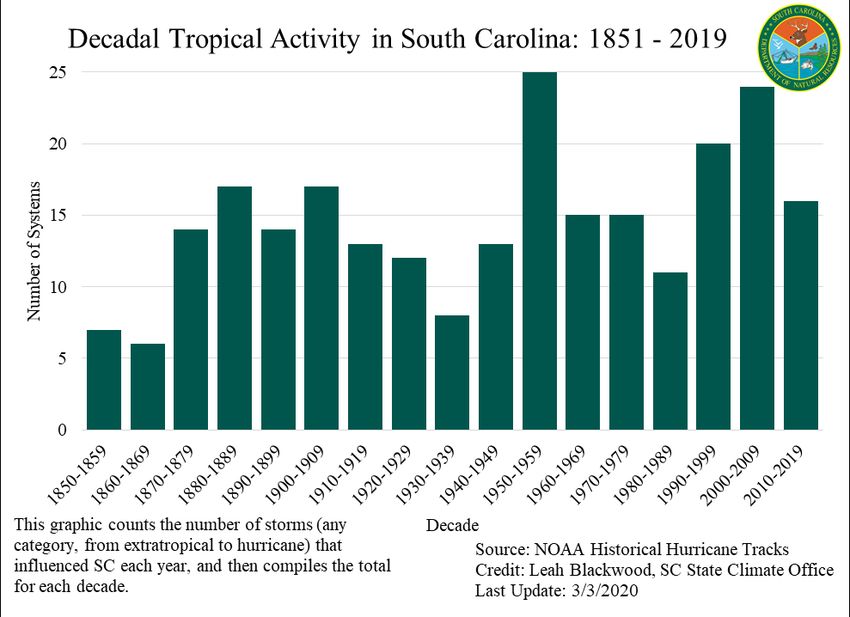
SC TROPICAL CYCLONE
CLIMATOLOGY

Understanding hurricanes and tropical storms are an essential piece of South
Carolina’s climatology, especially when considering the growth of coastal
communities. From 1851 – 2019, 41 tropical cyclones have made landfall along the
South Carolina coastline. Of these 41 systems that have directly hit the coast, only 4
have been confirmed major (Category 3+) hurricanes, according to the Saffir-Simpson
hurricane scale. There are no Category 5 hurricane landfalls on record for the state of
South Carolina. Three major Category 4 hurricanes have made landfall: Hazel (1954),
Gracie (1959), and Hugo (1989).
Many climatologists theorize that the “Great Storm of 1893” that struck the southern
coast on August 20, 1893 was at least a Category 4 hurricane, but prior to 1900, there
was no consistent and accurate measure for hurricane strength classification. For this
reason, it is classified as a Category 3.

SC TROPICAL CYCLONE
CLIMATOLOGY
The climatological record of South Carolina tropical activity before 1851 is somewhat
extensive, but less reliable than data beginning when record keeping became
consistent. Tropical cyclone records date back to 1686 for the Charleston area,
because of the large colonist population in Charleston at that time as compared to
other areas along our coast. In the 1600's and 1700's, tropical activity was usually
referred to as a “gale” or a “September gale”, which basically meant that a record
keeper noted especially strong winds and reported impacts. Many called them
“September gales” because of their noted tendency to come at harvest time and ruin
various crops and livestock populations for the colonists.
The famous hurricane of 1893 (discussed on the next page) was responsible for at
least 2,000 deaths. This is largely due to the lack of warning notices in that era.
Today, meteorologists are able to track a storm several days in advance and
anticipate the track. The improvements in forecast modeling and observation
methods allow residents in coastal areas to better prepare for an approaching
storm, and therefore saves lives.
NOTABLE HURRICANES:
A TIMELINE

SEPTEMBER 4, 1686
This storm is known for preventing a Spanish assault on the lower Carolina
settlements by driving two of their galleys on shore and forcing retreat. The storm
brought severe damage to the Charleston area.

AUGUST 28,1893
1893 marked the beginning of telegraph communication capabilities, which meant
that areas with a large coastal population had the ability to be warned of incoming
harsh weather conditions. However, no warnings were disseminated to areas with
lower populations, such as the Sea Islands. On August 28, 1893, a hurricane thought
by many to have been a Category 4 or 5 made landfall in South Carolina at high tide,
creating an enormous storm surge that swept over and submerged many Sea Islands.
Maximum winds in the Beaufort, SC area were estimated to be 125 miles per hour,
and winds in Charleston were estimated to be approximately 120 miles per hour. At
least 2,000 residents of South Carolina died from this event, and an estimated 20,000
– 30,000 people lost their homes. This storm, appropriately called the “Great Storm of
1893”, is currently classified as a Category 3 hurricane.
NOTABLE HURRICANES:
A TIMELINE
JULY 14, 1916
When this storm made landfall near Awendaw, SC, it was a Category 2, with winds
recorded at over 80 mph. It moved slowly as a stalled system over eastern South
Carolina, which resulted in record rainfall and widespread flooding. A reporting
station in Effingham, SC recorded 13.25 inches of rain in 24 hours.

AUGUST 11, 1940
This Category 2 storm made landfall near Beaufort, SC. The winds measured at 105
mph, and widespread rainfall greater than 10 inches fell in most of the state. 34
people were killed in this storm.

OCTOBER 15, 1954: HURRICANE HAZEL
Hurricane Hazel is one of the most memorable storms in South Carolina history. Hazel
made landfall as a Category 4 storm near Little River, S.C., which is located near the
state border with North Carolina. At landfall, Hazel had 106-miles per hour wind gusts
and 16.9 foot storm surge. One person was killed, and the damage was estimated at
$27 million.

SEPTEMBER 29, 1959: HURRICANE GRACIE
Gracie, a Category 4 hurricane, made landfall on St. Helena Island with 130 mph
winds and continued toward the north-northwest. Substantial damage occurred
along the coast from Beaufort to Charleston. Flooding occurred through much of the
State and crop damage was severe. NOAA's Hurricane Re-analysis Project upgraded
Gracie from a Category 3 to a Category 4 hurricane in June of 2016.

SEPTEMBER 21, 1989: HURRICANE HUGO
Hugo (September 1989) made landfall near Isle of Palms with wind gusts more than
160 mph during the night of 21st. It maintained hurricane force winds as far inland as
Sumter, where gusts reached 109 mph. Hugo caused 35 related fatalities and
damages more than $7 billion, making it the costliest hurricane in SC history, but not
the deadliest. Forested areas in 36 counties along the path of the storm sustained
significant damage.
SC LANDFALLS: 1851-2018
YEAR DATE      NAME      SC CAT   LOCATION
1867    6/21   UNNAMED      1       Charleston
1874    9/28   UNNAMED      1       Mt. Pleasant
1878    9/12   UNNAMED      1        Beaufort
1883    9/11   UNNAMED      3     NC/SC State Line
1885    8/25   UNNAMED      2        Beaufort
1893   10/13   UNNAMED      3        Awendaw
1894    9/27   UNNAMED      1        Beaufort
1898    8/31   UNNAMED      1     GA/SC State Line
1899   10/31   UNNAMED      2      Myrtle Beach
1904    9/14   UNNAMED      1       Georgetown
1906    9/17   UNNAMED      1       Georgetown
1908   10/23   UNNAMED     EX       Georgetown
1911    8/28   UNNAMED      2     GA/SC State Line
1913   10/08   UNNAMED      1       Charleston
1916    5/15   UNNAMED     TS       Fripp Island
1916    7/14   UNNAMED      2        Awendaw
1927   10/02   UNNAMED     TS        Beaufort
1928    9/18   UNNAMED      1      Edisto Beach
1940    8/11   UNNAMED      2     GA/SC State Line
1946    7/05   UNNAMED     TS     NC/SC State Line
1952    8/30     ABLE       2        Beaufort
1952    8/27   UNNAMED     TS      Myrtle Beach
1954   10/15    HAZEL       4     NC/SC State Line
1959     7/7    CINDY       1        Awendaw
SC LANDFALLS: 1851-2018
YEAR DATE                    NAME             SC CAT            LOCATION
 1959           9/29          GRACIE                4              Beaufort
 1971           9/10        UNNAMED                TS            Charleston
 1976           8/20          DOTTIE               TS            Charleston
 1976           9/14        UNNAMED                SS              Beaufort
 1979           6/15        UNNAMED                TD           Kiawah Island
 1985           7/25           BOB                 TS              Beaufort
 1987            9/7        UNNAMED                TD         NC/SC State Line
 1988           8/28          CHRIS                TS         GA/SC State Line
 1989           9/21          HUGO                  4           Isle of Palms
 1994           7/20        UNNAMED                TD            Georgetown
 2002          10/11           KYLE                TS             Bulls Bay
 2004           8/14         CHARLEY                1           Cape Romain
 2004           8/28         GASTON                 1             Awendaw
 2008            9/4          HANNA                TS         North Myrtle Beach
 2015            5/7           ANA                 TS            Myrtle Beach
 2016           10/7        MATTHEW                 1           McClellanville
 2016           5/28         BONNI E               TD            Mt.Pleasant

TROPICAL SYSTEMS CAN HAVE A TREMENDOUS
IMPACT ON THE STATE WITHOUT MAKING LANDFALL.
Throughout South Carolina's history of tropical cyclones, many of the storms that
caused significant impacts did not make a direct landfall along the coast. Some of the
worst hurricane-related hazards, such as inland flooding, storm surge and tornado
outbreaks were associated with tropical cyclones that made landfall elsewhere. The
next page discusses these impacts in more detail.
INLAND FLOODING
Flooding from tropical cyclones is not correlated with
the intensity of the storm, but rather the speed at
which the storm moves across an area. Heavy
torrential rains can occur hundreds of miles away
from the center of the storm. A slow-moving Tropical
Storm Florence (2018) dropped more than 30 inches
of rain across portions of eastern North Carolina,
and over 20 inches of rain in Chesterfield and Horry
counties, causing extensive flooding within the Pee
Dee Watershed that lasted for weeks.
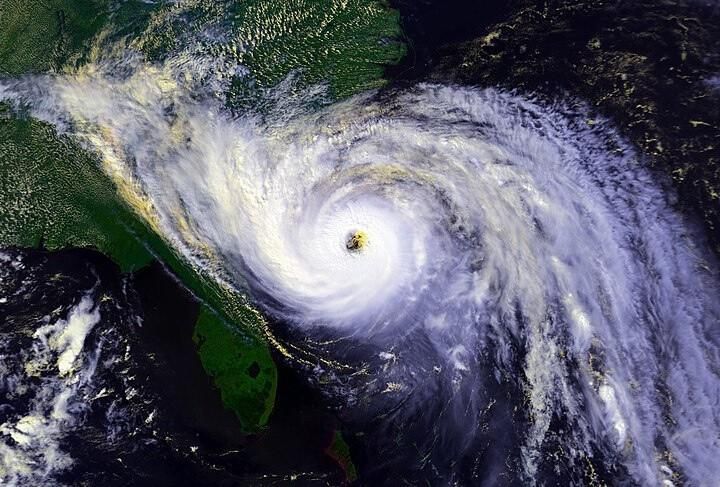
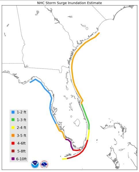
STORM SURGE
It is crucial that coastal communities
understand the impacts of storm surge and
local tides, which can combine to create
hurricane storm tides. As Hurricane Irma (2017)
made landfall in southwest Florida, the
combined effect of storm surge and the high
tide produced maximum inundation levels of 3
to 5 ft above ground level along the coast of
Georgia and much of South Carolina.
TORNADOES This graphic shows Hurricane Irma's storm surge
(2017). It is not intended to represent av erage
storm surge in South Carolina.
Tornadoes produced by tropical cyclones form in
the outer rainbands, which can be hundreds of
miles away from the center of the storm.
Hurricane Frances (2004) made landfall along the
east coast of Florida and spawned over 100
tornadoes across the Southeast; including 47
tornadoes in South Carolina. One of which was an
F3 (winds between 158 – 206 mph) in Kershaw
County that destroyed buildings and mobile
homes near the city of Camden.You can also read