9:00 AM EDT Thursday, August 12, 2021 Tropical Depression Fred
←
→
Page content transcription
If your browser does not render page correctly, please read the page content below
Tropical Update
                                         9:00 AM EDT
                                  Thursday, August 12, 2021
                                   Tropical Depression Fred
                                      & Invest 95L (60%)

This update is intended for government and emergency response officials, and is provided for informational and situational
awareness purposes only. Forecast conditions are subject to change based on a variety of environmental factors. For
additional information, or for any life safety concerns with an active weather event please contact your County Emergency
Management or Public Safety Office, local National Weather Service forecast office, or visit the National Hurricane Center
website at www.hurricanes.gov.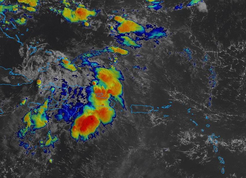
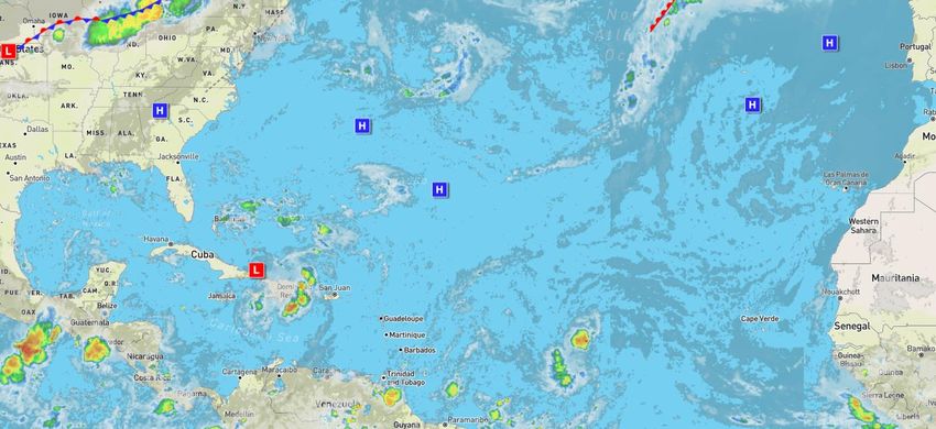
Atlantic Basin Satellite Image
Chance of development:   None   Low   Medium   High
Satellite Imagery
Tropical Depression Fred
                            The center of Fred emerged from
                              Haiti last night and is passing
                                between the southeastern
                             Bahamas and eastern Cuba this
                             morning. Strong thunderstorm
                               activity is displaced from the
                            center, but as Fred moves toward
                           the Florida Straits, more organized
                              storm activity should begin to
                           concentrate again near the center
                            and allow it to slowly strengthen.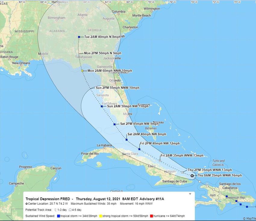
Official Forecast Track
From the National Hurricane Center
                              •   The center is Fred is located near Great Inagua Island in
                                  the southeastern Bahamas, or about 515 miles southeast
                                  of Miami, Florida.

                              •   Maximum sustained winds are around 35 mph. Little
                                  change in strength is forecast today, but slow
                                  strengthening is expected Friday and this weekend.

                              •   Fred is moving west-northwest at 16 mph, and this motion
                                  with a decrease in forward speed is expected during the
                                  next couple of days, followed by a turn to the northwest.

                              •   On the forecast track, Fred is expected to move across the
                                  southeastern Bahamas today, move along or just north of
                                  Cuba today and Friday, and be near the Florida Keys and
                                  South Florida on Saturday.

                              •   A second landfall is expected along the Florida Panhandle
                                  or Big Bend coast early Monday morning.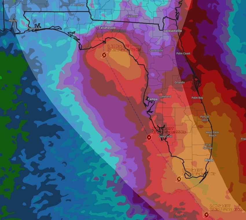
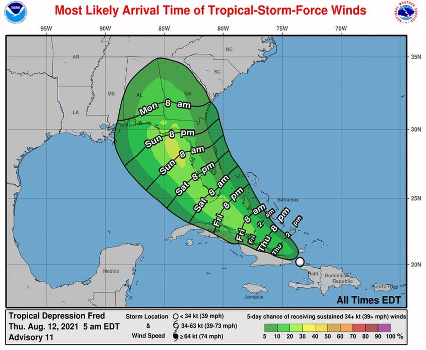
Time of Arrival & Wind Speed Probabilities
Most Likely Time of Arrival of Tropical Storm Force Winds (>39 mph)
                                            City                             Chance for      Changes Since
                                                                             TS Winds        Last Packet
                                            West Palm Beach                  12%             +1%
                                            Miami                            11%             +2%
                                            Key West                         23%             +1%
                                            Naples                           25%             +2%
                                            Ft. Myers                        13%             +2%
                                            Tampa                            23%             +1%
                        Jacksonville 12%    Cedar Key                        23%             +2%
                                            Tallahassee                      17%             -2%
                                            Apalachicola                     25%             +0%
                            Orlando 30%     Panama City                      22%             +0%
                                            Pensacola                        9%              -2%
                                            Orlando                          9%              +1%
                              Miami 9%
                                            There is a near 25% or 1 in 4 chance of tropical storm force winds
                                           for the Florida Keys and coastal areas along the Florida West Coast
                                             and Big Bend, with about a 10% or 1 in 10 chance in Southeast
                                           Florida and across inland areas. The earliest reasonable arrival time
                                           of tropical storm force winds in South Florida is Friday evening, but
                                            are most likely to begin late Friday night through Saturday. Winds
                                                        arrive on Saturday night/Sunday elsewhere.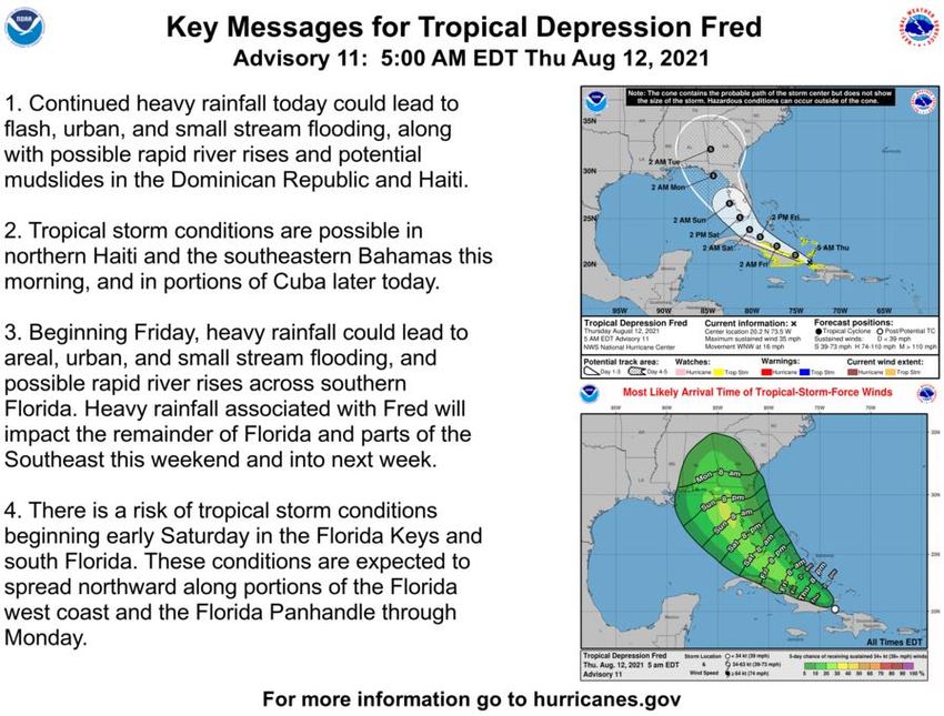
Key Messages
From the National Hurricane Center
Model Forecast Tracks & Intensity
Dynamical and Statistical Models – Tropical Storm Fred
                                     There still remains some uncertainty in
                                   regards to the forecast track and intensity
                                  for Fred. Minor adjustments to the forecast
                                   track may continue to occur and all within
                                  the cone of error should continue to closely
                                              monitor the forecast.

                                   Many computer models are indicating that
                                     Fred is likely to strengthen, but remain a
                                   tropical storm through landfall due to land
                                    interaction, some dry air, and wind shear.
                                  If Fred moves far enough off the West Coast
                                     of Florida in the Gulf of Mexico, it could
                                   strengthen more than currently indicated,
               Statistical        but tropical storm impacts are still expected
                Models               to affect much of the Florida Gulf Coast
                                                  through Monday.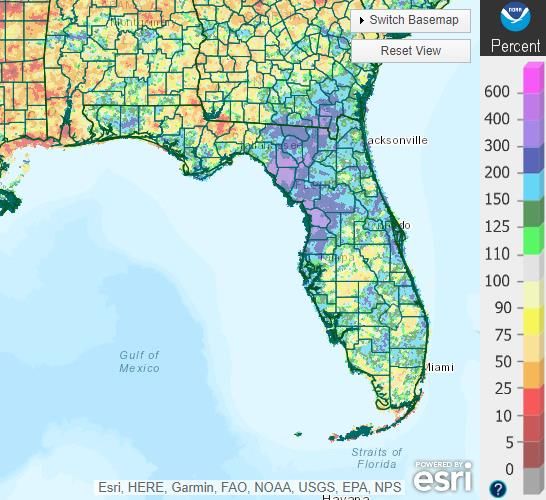
Rainfall Totals Next 7 Days
Ending 8 PM ET Tuesday
                         One of the main threats to Florida from Fred
                         will be heavy rainfall, first affecting much of
                         South Florida starting on Friday and
                         continuing into the weekend. The heavy rain
                         threat will then move into North Florida
                         Sunday and Monday.

                         A widespread 3-5” of rain is expected near
                         and south of Lake Okeechobee (including the
                         Keys) with localized totals of 8”.

                         *Exact rainfall totals across North Florida WILL
                         CHANGE as the forecast track and intensity is
                         fine tuned. These are first guess totals based
                         on the current NHC forecast and do not
                         account for isolated higher totals that are
                         possible.*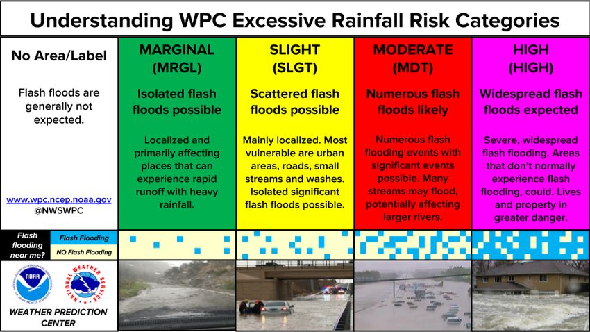
Rainfall Anomaly – Soil Moisture

                   The areas in BLUE & PURPLE
                        have seen double to
                   quadruple the normal rainfall
                    over the last 2 weeks (6-10”
                    above normal). These areas
                    are very susceptible to flash
                      flood and river flooding.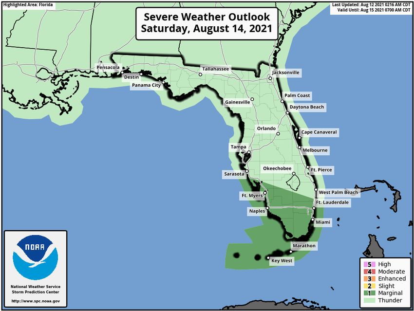
Flash Flood Outlook for Friday-Saturday
From the Weather Prediction Center (LINK)

                                     Rain bands will begin to arrive in
                                     Southeast Florida later on Friday
                                     afternoon and continue into
                                     Saturday. Isolated flash flooding
                                     will be possible, especially in
                                     urban and low-lying areas.
Current & Forecast River Flooding
North Florida – Southeast River Forecast Center
Extensive river flooding will continue
across Northeast Florida this week. Heavy
rain could fall on rivers already in
moderate flood stage which could result
in additional, significant flooding.
More details on river levels available at the
Southeast River Forecast Center website.Tornado Risk - Saturday
Isolated tornadoes will be possible in the
outer band of Fred as it passes South
Florida on Saturday.
The threat will expand northward along
the Gulf Coast into Sunday and Monday.Tropical Weather Outlook
Possible Areas of Development During the Next 5 Days (LINK) – Invest 95L
Showers and thunderstorms remain
disorganized in association with a tropical wave
located about 1400 miles east of the Lesser
Antilles. Environmental conditions are
expected to gradually become more conducive
for development, and a tropical depression
could form by early next week while the system
moves generally westward at about 20 mph
across the tropical Atlantic. This system is
expected to reach portions of the Leeward
Islands late Saturday or early Sunday, following
in a similar path as Fred. Development chances
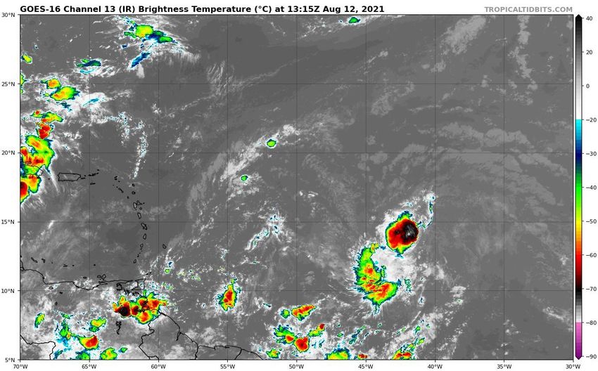
have increased.Satellite Imagery
Central Atlantic Wave – 95L
Development chances have
increased for 95L as it appears
that it is becoming better
organized with a broad center
of low pressure.
Chance of FormationModel Forecasts
Ensembles, Dynamical, and Statistical Models – Invest 95L
Computer models are split on
track and intensity for 95L,
which is common in weak and
developing systems. Many
keep the system weak and
eventually dissipate the
system near the Lesser Antilles
or Hispaniola while others
show a possibility for a
stronger storm moving
towards the Bahamas and
curving northward just east of
Florida.Overall Summary
Tropical Depression Fred:
• The center is Fred is located off the northeastern coast of Cuba, about 515 miles southeast of Miami, Florida.
• Fred currently has maximum sustained winds around 35 mph, but slow strengthening is expected over the next 72 hours.
• Fred is moving west-northwest at 16 mph and this general motion will continue over the next few days. This weekend, a northwest turn is expected over the
eastern Gulf of Mexico.
• On the forecast track, Fred is expected to move across the southeastern Bahamas today, move along or just north of Cuba today and Friday, and be near the
Florida Keys and South Florida on Saturday.
• A second landfall is expected along the Florida Panhandle or Big Bend coast early Monday morning.
Invest 95L
• A tropical wave located over the eastern tropical Atlantic 1,400 miles east of the Lesser Antilles has a 60% chance of becoming a tropical depression by early next
week while moving generally westward across the tropical Atlantic near 20 mph.
Florida Outlook:
• Tropical Depression Fred will bring increased rain chances and gusty winds to South Florida on Friday and Saturday and other regions of the state this weekend
and into early next week.
• Much of Florida remains within the 5-day forecast cone for where the center of the storm is most likely to travel.
• There are currently no tropical storm watches for Florida, but they are likely to be issued later this morning and this afternoon for portions of South Florida.
• One of the main threats to Florida from Fred is heavy rainfall. A widespread 3-5” of rain with localized totals of 8” are anticipated across the Florida Keys and
South Florida (generally south of Lake Okeechobee).
• The heavy rain threat will extend northward along the Nature Coast and Florida Big Bend later in the weekend.
• Widespread minor to moderate river flooding will continue this week in Northeast Florida. Heavy rainfall may continue or worsen flooding.
• Isolated tornadoes are also possible in South Florida and the Keys on Friday and Saturday.
• It is too early to determine storm surge impacts, but is anticipated to be minimal at this time for South Florida. A more minor to moderate threat may exist for
portions of Apalachee Bay.
Another briefing packet will be issued this afternoon with the 5pm advisory. For the latest information on the tropics, please visit the National Hurricane Center
website at www.hurricanes.gov.Tropical Update
Created by:
Amy Godsey, Chief State Meteorologist
Amy.Godsey@em.myflorida.com
State Meteorological Support Unit
Florida Division of Emergency Management
Users wishing to subscribe (approval pending) to this distribution list, register at:
https://public.govdelivery.com/accounts/FLDEM/subscriber/new?topic_id=SERT_Met_Tropics.
Other reports available for subscription are available at:
https://public.govdelivery.com/accounts/FLDEM/subscriber/new?preferences=trueYou can also read