5 PM EDT Sunday, October 7, 2018 Tropical Storm Michael, Tropical Storm Leslie, Florida Association of Counties
←
→
Page content transcription
If your browser does not render page correctly, please read the page content below
Tropical Update
                        5 PM EDT
                  Sunday, October 7, 2018
       Tropical Storm Michael, Tropical Storm Leslie,
                    & Invest 92L (30%)
This update is intended for government and emergency response officials, and is provided for
informational and situational awareness purposes only. Forecast conditions are subject to
change based on a variety of environmental factors. For additional information, or for any life
safety concerns with an active weather event please contact your County Emergency
Management or Public Safety Office, local National Weather Service forecast office or visit the
National Hurricane Center website at www.nhc.noaa.gov.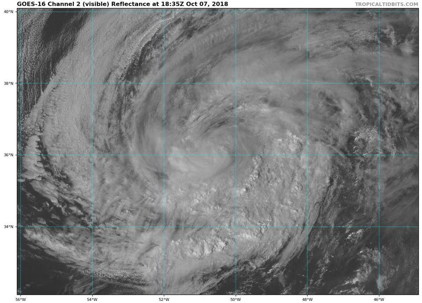
Atlantic Basin Satellite Image
Steering Pattern
  Michael is currently being blocked by a large area of high pressure which will result in little movement
 tonight. However, the high will weaken and shift eastward with a cold front approaching from the west.
This will allow Michael to move northward tomorrow and Tuesday and eventually northeast. Leslie and the
                          non-tropical low will continue to move east or southeast.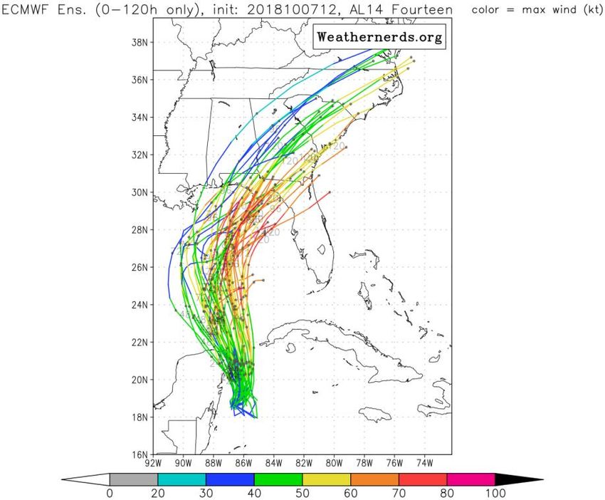
Wind Shear (shaded) and Wind Shear Tendencies (contoured)
  Strong wind shear in the northwestern Caribbean and Yucatan Channel have prevented any rapid
 development today. However, this wind shear is forecast to relax which will allow strengthening of
Michael into a hurricane once it moves into the Gulf of Mexico. Leslie and the non-tropical low will see
                 increasing wind shear over the coming days, limiting development.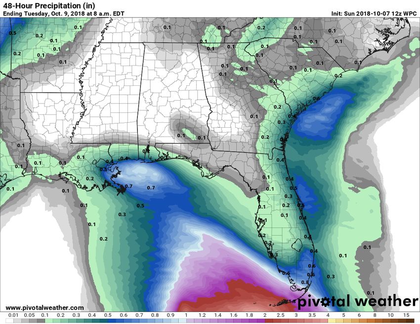
Current Sea Temperatures and Ocean Heat Content

                                   Ocean temperatures and the
                                    depth of warm water (heat
                                     content) is sufficient for
                                  development in the Caribbean
                                         and central Gulf.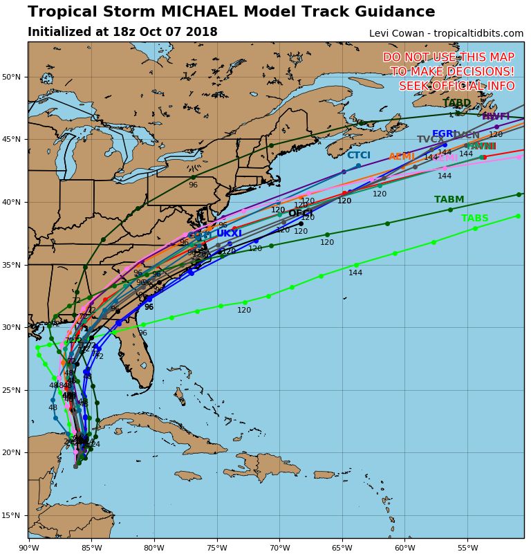
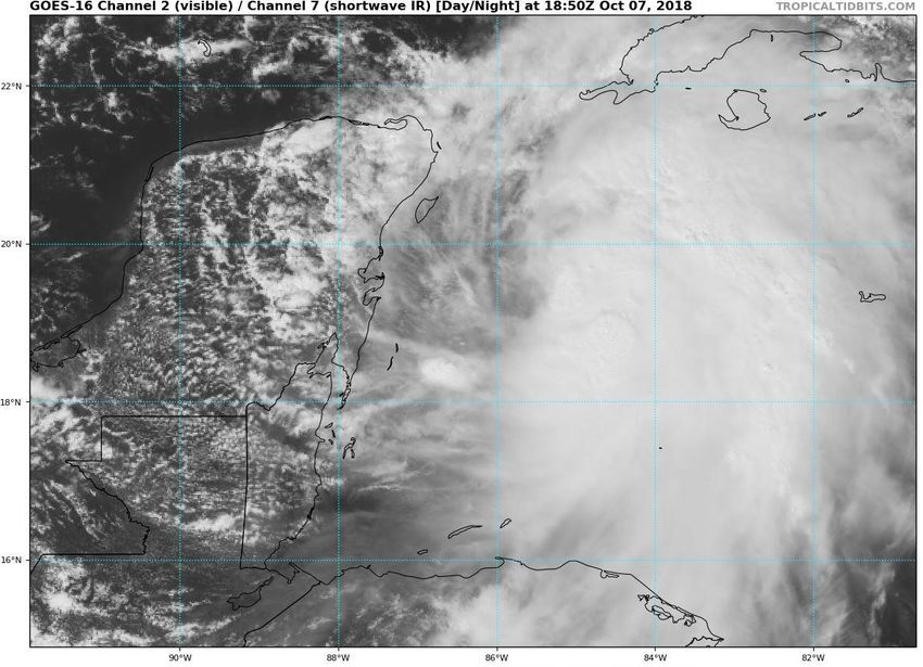
Tropical Storm Michael Satellite Image
                           Due to the ongoing wind
                        shear, most of the cloud cover
                        is displaced to the east of the
                        center and the center remains
                         elongated. However, Michael
                         is gradually becoming better
                                  organized.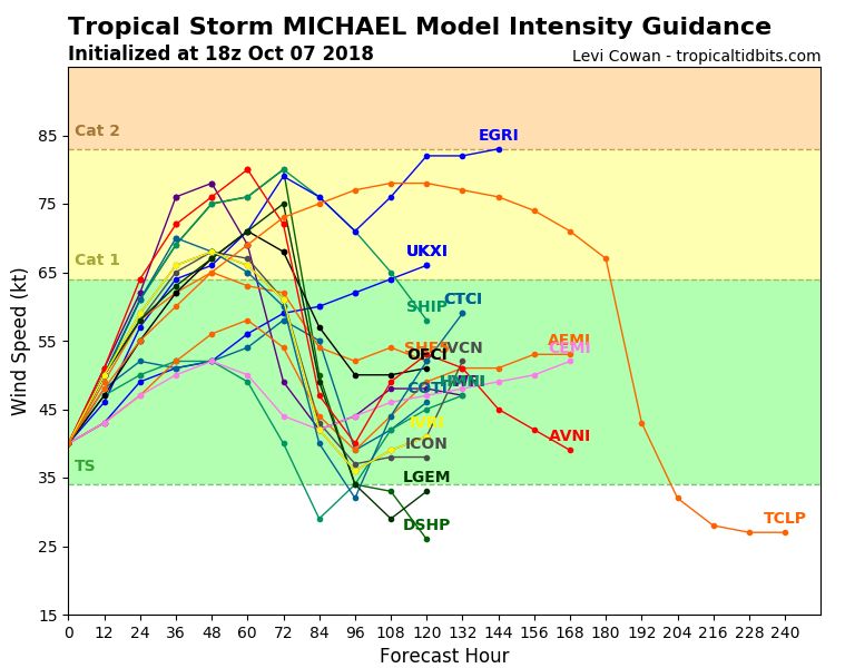
Leslie will move slowly southwestward over the next
few days, but it will accelerate northeast again later
this week. Leslie may strengthen to a hurricane when it
moves southwest over warmer waters.                          The system will generally
                                                          accelerate north over the next
                                                          48 hours before making a turn
                                                          towards the northeast due to
                                                            an approaching cold front.
                                                          Strengthening into a hurricane
                                                            is currently forecast before
                                                                      landfall.

                                                             The track has shifted east,
                                                           timing for landfall was pushed
                                                             back, and intensity before
                                                          landfall has increased since the
                                                                 previous advisory.
Current Model
    Tracks

Confidence continues to
increase on the landfall
location now that the
center of the storm is
better defined.

However, there is some
discrepancy in forward
speed. A faster storm
will tend to make
landfall in the
Panhandle while a
slowly storm may curve
more northeast into the
Big Bend.
More models now show this system becoming a Category 1 Hurricane Tuesday or Wednesday before landfall.
Tropical Storm force winds may
arrive as early at Tuesday evening,
but no later than Wednesday
morning. Odds of seeing tropical
storm force winds (>39 mph) have
increased to over 60% for much of
the Panhandle and Big Bend.

Tampa: 34%
Jacksonville: 43%
Tallahassee: 64%
Apalachicola: 75%
Panama City: 73%
Pensacola: 50%
Odds of seeing hurricane force
winds have increased to around
10% along the Panhandle and Big
Bend and up to 20% in
Apalachicola. This will likely
increase in future advisories.
Forecast Cumulative Rain Totals – Next 48 Hours
  Rain bands from Tropical Storm Michael will begin to impact the Florida Keys later today
  into tomorrow. Localized rainfall amounts of 2-4” will be possible along with an increased
  threat of waterspouts. Winds will be breezy, out of the east and southeast at 20-30 mph.
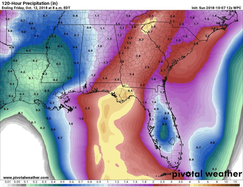
Forecast Cumulative Rain Totals – Next 5 Days
Actual rain totals will be dependent on the strength and track of Michael and this graphic
does not account for isolated higher totals. However, a general 3-6” can be expected
across the Panhandle and Big Bend Tuesday-Thursday. Localized totals of 8-10+” possible.
Forecast Wave Heights

Ocean swells will increase the rip current threat
along the Panhandle coast and West Coast
starting tomorrow.
Wave heights along the Panhandle and Big Bend
may peak at 8-10’ at the beach and much higher
offshore. Beach erosion likely.
Forecast Water Levels
                                      at Select Tidal Gauges

Storm surge amounts will depend on exact track and
intensity! More details will become available tomorrow
morning from NHC.
These are for planning purposes worst case:
4-6’ in Central/eastern Panhandle
6-10’ for Apalachee Bay
3-5’ Nature Coast
https://www.weather.gov/serfc/
Tropical Storm Leslie Satellite Image Leslie has maintained strength as it moves east and southeast between Bermuda and the Azores. It is no threat to the U.S. or Caribbean.
Leslie will move slowly southwestward over the next
few days, but it will accelerate northeast again later
this week. Leslie may strengthen to a hurricane when it
moves southwest over warmer waters.
Florida Rip
 Current Risk
Ocean swells from Tropical Storm Leslie will
continue a moderate to high risk of rip
currents for all East Coast beaches. Swells
from Tropical Storm Leslie will decrease over
the coming days as Leslie moves away from
the U.S.
Marine conditions along the Gulf Coast will
begin to deteriorate next 24-48 hours as
Michael moves north out of the Caribbean.
Leslie will move slowly southwestward over the next
        few days, but it will accelerate northeast again later
        thisnon-tropical
1. A broad   week. Leslielowmay  strengthen
                             pressure          to a hurricane
                                      system located            whenmiles
                                                      a few hundred    it south
        moves
   of the Azoressouthwest
                 continues toover  warmer
                              produce        waters.
                                       a large area of disorganized showers and
    thunderstorms, mainly to the north and east of its center. This system could
    gradually acquire subtropical or tropical characteristics over the next day or
    two while it moves slowly eastward. By Tuesday, environmental conditions
    are expected to become unfavorable for further development to occur.
* Formation chance through 48 hours...low...30 percent.
* Formation chance through 5 days...low...30 percent.
Tropical Storm Leslie:
Summary
• At 5 PM EDT Sunday, Tropical Storm Leslie was located about 800 miles east-northeast of Bermuda.
• Maximum sustained winds remain near 60 mph, and small fluctuations in intensity are expected over the next several days
• Leslie continues to move east-southeast at 10 mph. Leslie will continue east-southeast or turn southeast and accelerate through the middle
of next week in the open waters of the north-central Atlantic.
Invest 92L
• A broad non-tropical low pressure system located a few hundred miles south of the Azores has a 30% (low) chance of acquiring tropical or
sub-tropical characteristics in the next 48 hours or 5 days. This system is no threat to the U.S. or Caribbean as it moves east.
Tropical Storm Michael
• At 1 PM EDT Sunday, Tropical Depression #14 strengthened enough to be designated Tropical Storm Michael.
• As of 5 PM EDT Sunday, Tropical Storm Michael was located about 90 east of Chetumal, Mexico, or about 800 miles south of Pensacola, FL.
• Maximum sustained winds are near 50 mph and Michael is moving north-northeast at 3 mph.
• Michael is expected to strengthen into Hurricane by Tuesday before it makes landfall sometime on Wednesday between Pensacola, FL and
Cedar Key, FL. While models have come into better agreement today, there remains some uncertainty, especially in timing of landfall.
• Hurricane hunters are currently investigating this system and will be regularly for the next few days.
Florida Outlook:
• Tropical Storm Leslie continues producing a large area of long-period swells that will impact the East Coast of Florida for the next few days,
resulting in a moderate to high risk of rip currents along all Atlantic beaches.
• An increase in swells and rip current risks from Michael will be possible along the Florida Panhandle and West Coast as early as tomorrow.
Wave heights at Panhandle and Big Bend beaches may be as high as 8-10’ Tuesday night through Thursday morning.
• Exact impacts from Michael will depend on strength and track. Hurricane, Tropical Storm, and/or Storm Surge Watches will likely be issued
tomorrow morning for some of the Panhandle and Big Bend where more details will become available.
• Regardless, tropical storm conditions may arrive in the Panhandle as soon as Tuesday evening but no later than late Wednesday morning.
• Widespread rainfall totals of 3-6” with locally higher amounts of 8-10+” can be expected across the Panhandle and Big Bend.
• Storm surge values will be highest near landfall, but even with a landfall in the Panhandle some surge is still expected in Apalachee Bay. For
planning purposes: 4-6’ in Panhandle, 6-10’ in Apalachee Bay, 3-5’ Nature Coast
• Increased rain chances are expected today and tomorrow across the Florida Keys. Locally 2-4” of rain. 1-2” across the Peninsula.
• Isolated tornadoes will be possible Tuesday-Thursday, but risk and where will depend on eventual track and intensity of the system.
Another briefing packet will be issued Monday morning. For the latest information on the tropics, please visit the National Hurricane Center
website at www.hurricanes.gov.Tropical Update
Created by:
Michael Spagnolo, Deputy State Meteorologist
Michael.Spagnolo@em.myflorida.com
State Meteorological Support Unit
Florida Division of Emergency
Management
Users wishing to subscribe (approval pending) to this distribution list, register
at https://public.govdelivery.com/accounts/FLDEM/subscriber/new?topic_id=SERT_Met
_Tropics.
Other reports available for subscription are available at
https://public.govdelivery.com/accounts/FLDEM/subscriber/new?preferences=trueYou can also read