5 AM EDT Monday, October 8, 2018 Tropical Storm Michael, Tropical Storm Leslie, Invest 92L (10%) & African Tropical Wave (50%) - Florida ...
←
→
Page content transcription
If your browser does not render page correctly, please read the page content below
Tropical Update
                        5 AM EDT
                  Monday, October 8, 2018
       Tropical Storm Michael, Tropical Storm Leslie,
      Invest 92L (10%) & African Tropical Wave (50%)
This update is intended for government and emergency response officials, and is provided for
informational and situational awareness purposes only. Forecast conditions are subject to
change based on a variety of environmental factors. For additional information, or for any life
safety concerns with an active weather event please contact your County Emergency
Management or Public Safety Office, local National Weather Service forecast office or visit the
National Hurricane Center website at www.nhc.noaa.gov.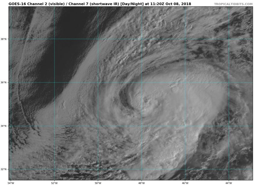
Atlantic Basin Satellite Image
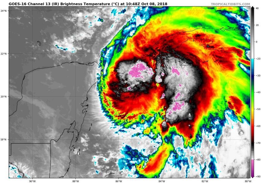
Tropical Storm Michael Satellite Image
Thunderstorms are wrapping
     around the center of
 circulation, an indication of
        intensification.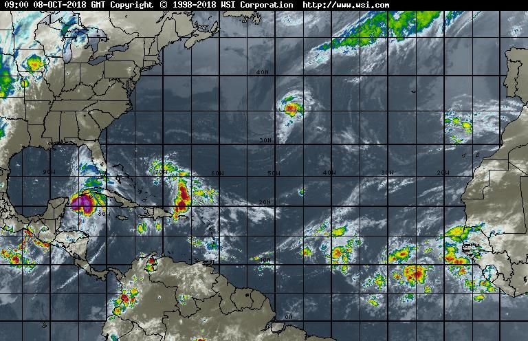
Wind Shear (shaded) and Wind Shear Tendencies (contoured)
 Moderate wind shear is exists near Michael but is forecast to relax which will allow strengthening of
Michael into a hurricane once it moves into the Gulf of Mexico. Wind shear in the eastern Atlantic may
            inhibit development of the African Tropical Wave, especially later in the week.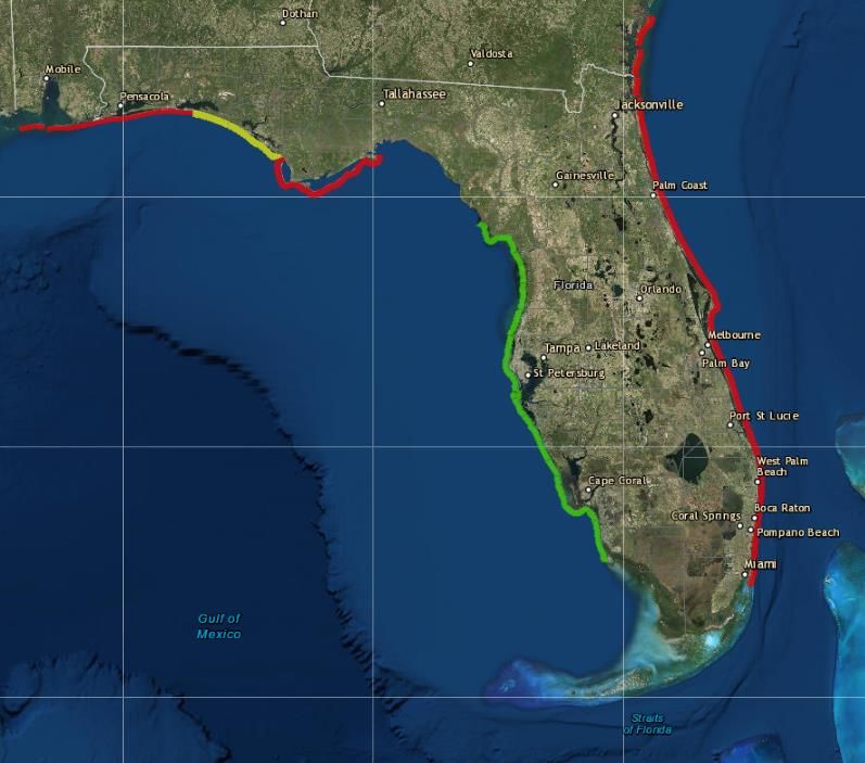
Forecast
Weather
 Maps
Michael will initially be
  steered northward
between high pressure
to the northeast and a
    cold front to the
 northwest. A turn to
   the northeast will
 occur by Wednesday
as Michael is primarily
  steered by the cold
          front.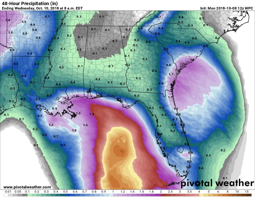
The track forecast for Michael has not
  changed much in the past 24 hours,
  but the intensity prior to landfall has
    increased since yesterday and is
forecast to be either a strong Category
  2 or Category 3 storm at landfall on
          Wednesday evening.

Hurricane Watches and Tropical Storm
Watches issued. Storm Surge Watches
              issued.
Leslie will move slowly southwestward over the next
 few days, but it will accelerate northeast again later
 this week. Leslie may strengthen to a hurricane when it
 moves southwest over warmer waters.

Michael is currently forecast to
 strengthen to a Category 2
       before landfall.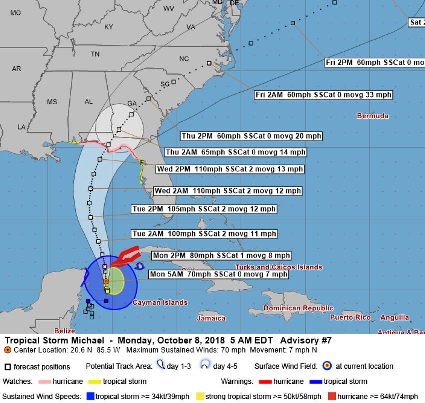
Tropical Storm
Watch

Hurricane Watch
Tropical Storm force winds may arrive
as early at Tuesday evening, but no later
than Wednesday morning. Odds of
seeing tropical storm force winds (>39
mph) have increased to over 70% for
much of the eastern Panhandle and
western Big Bend.

Tampa: 34% (+0)
Orlando: 25%
Jacksonville: 45% (+2)
Tallahassee: 81% (+17)
Apalachicola: 92% (+17)
Panama City: 91% (+18)
Pensacola: 54% (+4)

Odds of seeing hurricane force
winds have increased to around a 1
in 4 chance along the Panhandle
and Big Bend and a 1 in 3 chance
near the coast of Apalachicola. This
will likely increase in future
advisories.
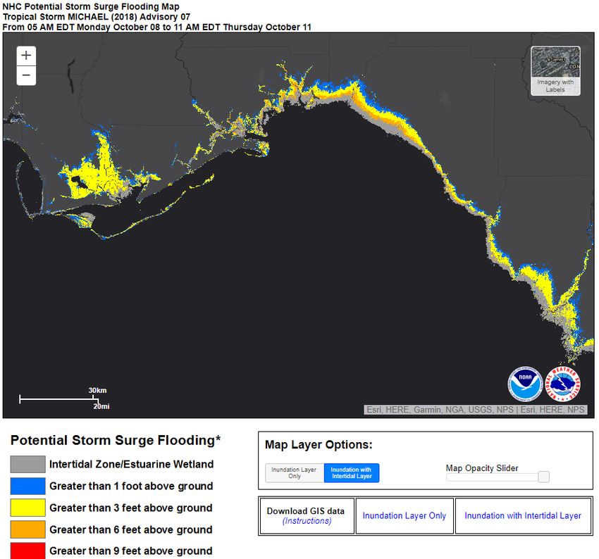
Storm surge could
inundate areas
several miles inland
Forecast Cumulative Rain Totals – Next 48 Hours
  Rain bands from Tropical Storm Michael will begin to impact the Florida Keys today.
  Localized rainfall amounts of 1-3” will be possible along with an increased threat of
  waterspouts. Winds will be breezy, out of the east at 20-30 mph.
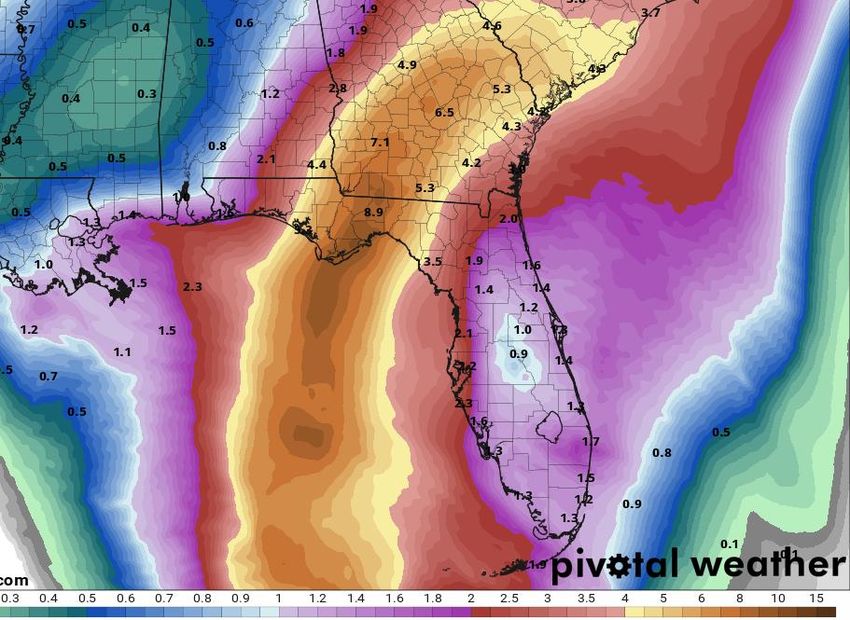
Forecast Cumulative Rain Totals – Next 5 Days
Actual rain totals will be dependent on the strength and track of Michael and this graphic does
not account for isolated higher totals. However, a general 4-8” can be expected across the
Panhandle and Big Bend Tuesday night-Thursday morning. Localized totals of 8-12+” possible.
Forecast Wave Heights

Ocean swells will increase the rip current threat
along the Panhandle coast and West Coast
starting today.
Wave heights along the Panhandle and Big Bend
may peak at 10-20’ at the beach and much higher
offshore. Beach erosion likely.
Florida Rip
 Current Risk
Lingering ocean swells from Tropical Storm
Leslie and breezy onshore winds will continue
a high risk of rip currents for all East Coast
beaches. Swells from Tropical Storm Michael
will increase the rip current threat for the
Florida Panhandle and Big Bend, as well as
the Florida West Coast this week.
Tropical Storm Leslie Satellite Image

 Leslie has maintained strength as it moves
 east and southeast between Bermuda and
 the Azores. It is no threat to the U.S. or
 Caribbean.
Leslie will move southeastward over the next few days,
but it will accelerate northeast again later this week.
Leslie may strengthen to a hurricane when it reaches
warmer waters on Thursday.
1. A broad non-tropical low pressure system located southeast of the Azores has not become any better organized and tropical or subtropical
development is not anticipated. * Formation chance through 5 days...low...near 0 percent.

2. An area of low pressure, associated with a tropical wave, is located several hundred miles south of the Cabo Verde Islands. Shower and
thunderstorm activity has become more concentrated since last night, and a tropical depression could form during next few days while it
moves west-northwestward. By late this week, however, upper-level winds are expected to become unfavorable for development. * Formation
chance through 48 hours...medium...40 percent. * Formation chance through 5 days...medium...50 percent.
Tropical Storm Leslie:
                                                        Summary
•     At 5 AM EDT Monday, Tropical Storm Leslie was located about 990 miles east-northeast of Bermuda.
•     Maximum sustained winds remain near 50 mph, and small fluctuations in intensity are expected over the next couple of days before
      strengthening is expected back to a hurricane later this week.
•     Leslie is moving east-southeast at 13 mph. Leslie will continue east-southeast or turn southeast and accelerate through the middle of next
      week in the open waters of the north-central Atlantic before a turn Northeast toward the Azores and Portugal.
Invest 92L
•     This system is no longer expected to develop. Odds have been dropped to 0% and it will be removed from future outlooks.
African Tropical Wave
•     A tropical wave several hundred miles south of the Cabo Verde Islands has become better organized overnight. A tropical depression may
      form during the next few days as it moves west-northwestward.
•     This system poses no threat to land over the next 5-7 days and is currently forecast to remain over the open Atlantic where it will eventually
      dissipate.
•     The National Hurricane Center gives this system a 40% (medium) chance of development over the next 48 hours and a 50% (medium) over
      the next 5 days.
Tropical Storm Michael
•     As of 8 AM EDT Monday, Tropical Storm Michael was located about 120 miles east of Cozumel, Mexico, or about 630 miles south of
      Panama City, FL, in the Yucatan Channel.
•     Maximum sustained winds are near 70 mph and Michael is moving north at 7 mph.
•     Michael is expected to become a hurricane later this morning and is forecast to continue strengthening up until landfall. Landfall is currently
      forecast as a Category 2 with 110 mph, but a Category 3 is possible given the recent rapid intensification.
•     Michael will continue to accelerate northward over the next 48 hours before making a turn towards the north-northeast or northeast as it
      makes landfall.
•     Landfall is expected in the Panhandle or Big Bend sometime on Wednesday, and there remains some discrepancy in forward speed. A faster
      storm will make landfall on the western side of the forecast cone, where a slower storm will make more of a northeast turn into the Big
      Bend.
•     Hurricane hunters will be investigating the system later this morning and again this evening.
Florida Outlook:
• Much of the Florida Panhandle and Big Bend remain within the cone of error for landfall potential.
• An increase in swells and rip current risks from Michael are already present and wave heights will
continue to increase through Thursday morning.
• Tropical storm conditions may arrive in the Panhandle as soon as Tuesday morning but no later than
late Wednesday morning. If the track shifts eastward or expands in size, the Florida West Coast could
experience tropical storm force winds tonight or early tomorrow morning. Hurricane conditions could
arrive in the Panhandle Wednesday afternoon or evening.
• Tropical Storm Wind Watches are in effect for 7 counties along the Florida West Coast and 2 counties
in the far eastern Big Bend. Hurricane Watches are in effect for 18 Panhandle and Big Bend counties
between Pensacola and Cross City. These may be upgraded to warnings later today.
• Storm surge will be one of the greatest impacts from this storm and may affect a large portion of the
Florida Gulf Coast. Storm Surge Watches have been issued between Navarre (Okaloosa County) and
Anna Maria Island (Manatee County) for possible surge inundation of 2-4’ for the Tampa Bay region
and western Panhandle, 4-7’ for the eastern Panhandle coast, and 7-11’ for Apalachee Bay and Nature
Coast.
• Widespread rainfall totals of 4-8” with locally higher amounts of 8-10+” can be expected across the
Panhandle and Big Bend, with most of it occurring on Wednesday.
• Isolated tornadoes will be possible Tuesday-Thursday, but risk and where will depend on eventual
track and intensity of the system (northeast quadrant relative to forward motion).
• Ocean swells from Tropical Storm Leslie and breezy onshore winds from high pressure to the north of
Florida will continue producing a moderate to high risk of rip currents along all Atlantic beaches.
Another briefing packet will be issued later this afternoon. For the latest information on the tropics, please
visit the National Hurricane Center website at www.hurricanes.gov.Tropical Update
Created by:
Amy Godsey, Chief State Meteorologist
Amy.Godsey@em.myflorida.com
Michael Spagnolo, Deputy State Meteorologist
Michael.Spagnolo@em.myflorida.com
State Meteorological Support Unit
Florida Division of Emergency Management
Users wishing to subscribe (approval pending) to this distribution list, register
at https://public.govdelivery.com/accounts/FLDEM/subscriber/new?topic_id=SERT_Met
_Tropics.
Other reports available for subscription are available at
https://public.govdelivery.com/accounts/FLDEM/subscriber/new?preferences=trueYou can also read