Microwave observations: cloud and precipitation; applications - Alan Geer - ECMWF May 6, 2021 - ECMWF ...
←
→
Page content transcription
If your browser does not render page correctly, please read the page content below
Microwave observations: cloud and
precipitation; applications

Alan Geer

 © ECMWF May 6, 2021
Information content in cloud and
precipitation

 © ECMWF May 6, 2021
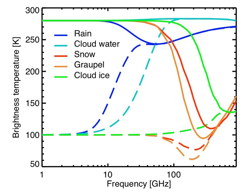
Effect of hydrometeors in microwave window channels Increasing frequency [GHz]
 (h = horizontal polarization)

 Observed TB [K]

 3

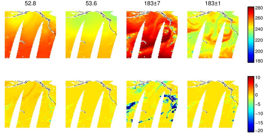
Effect of hydrometeors in microwave window channels Increasing frequency [GHz]
 (h = horizontal polarization)

 Observed TB [K]
 Hydrometeor effect: observed TB – Simulated clear-sky TB [K]

 Rain (absorption, increases TB) Cloud (absorption, Snow/graupel/hail (scattering,
 EUROPEAN CENTRE FOR MEDIUM-RANGE WEATHER FORECASTS
 increases TB) decreases TB) 4
Effect of hydrometeors in microwave sounding channels
 Temperature sounding: Water vapour sounding:
 Lower troposphere Mid troposphere Mid troposphere Upper troposphere

 Observed TB [K]

 5
Effect of hydrometeors in microwave sounding channels
 Temperature sounding: Water vapour sounding:
 Lower troposphere Mid troposphere Mid troposphere Upper troposphere

 Observed TB [K]
 Hydrometeor effect: observed TB – Simulated clear-sky TB [K]

 Cloud and rain (absorption, Cloud and snow/ice/graupel
 Cloud (absorption,
 pushes up weighting function (absorption and scattering,
 increases TB)
 altitude, decreases TB) decreases TB)
 6
Effect of hydrometeors
 Size parameter
• 30 GHz frequency ↔ 10mm wavelength (λ) 2pr
 x=
 l

 Particle type Size range, r Size parameter, x
 Cloud droplets 5 – 50 μm 0.003 – 0.03
 Drizzle ~100 μm 0.06
 Rain drop 0.1 – 3 mm 0.06 – 1.8
 Ice crystals 10 – 100 μm 0.006 – 0.06
 Snow 1 – 10 mm 0.6 – 6
 Hailstone ~10 mm 6

 EUROPEAN CENTRE FOR MEDIUM-RANGE WEATHER FORECASTS 7
Wavelength
Cloud and 100 mm 10 mm 1 mm
precipitation Slab cloud at 283K
optical properties: above a 280K
the microwave surface (solid)
spectrum

 Slab cloud at 283K
 above a 100K
 surface (dashed)

 Geer et al. (2021, GMD, submitted)

 EUROPEAN CENTRE FOR MEDIUM-RANGE WEATHER FORECASTS 8
To sensor
Strong scattering at
91 GHz
Reverse Monte-

 [km]
Carlo radiative
transfer solver

 Snow
 Cloud
 Rain

 [km]

 EUROPEAN CENTRE FOR MEDIUM-RANGE WEATHER FORECASTS 9
Scattering radiative transfer
Quick summary…

 © ECMWF May 6, 2021
Schwarzchild’s equation

 Planck function

 Radiance
 Change in
 radiance per = ! ( − )

 distance
 Absorption coefficient

 Loss through
 − !
 absorption

 + !
 Gain through
 thermal emission

 EUROPEAN CENTRE FOR MEDIUM-RANGE WEATHER FORECASTS 11
Adding scattering

 Extinction coefficient " = ! + #

 Scattering coefficient (describing the amount
 of scattering out of the beam)

 Loss through
 extinction − "

 Gain from scattering
 +? into the beam
 + !
 Gain through thermal emission

 EUROPEAN CENTRE FOR MEDIUM-RANGE WEATHER FORECASTS 12
Change in coordinates: optical depth

 Change in optical depth = − !
 d in a non-scattering
 atmosphere

 Change in optical depth = −( ! + # ) = − "
 d including extinction by
 scattering

 EUROPEAN CENTRE FOR MEDIUM-RANGE WEATHER FORECASTS 13
The full scattering radiative transfer equation
 Direction vector Integral over all solid angle
 -
 (Ω) #
 -
 = Ω − 1 − # − - Ω′)
 3 (Ω, - - Ω′
 Ω′ -
 4 $%

 Single scattering Scattering phase
 Change in albedo (SSA) function, often simplified
optical depth and summarised by ‘g’ –
 # asymmetry parameter
 # =
 ( ! + # )

• Without scattering, just integrate this equation along the path
 travelled by the radiation (Tony’s first lecture)
• With scattering, this can be complex to solve:
 Ω$ , the radiance in one direction, depends on radiance from all other
 $
 directions: Ω′
 and all levels depend on each other
 EUROPEAN CENTRE FOR MEDIUM-RANGE WEATHER FORECASTS 14
Fast • For each hydrometeor type (e.g. cloud, rain etc.), compute single-species bulk
approximate optical properties as a function of mixing ratio
solver: • Sum up single-species optical properties along with gas optical properties
RTTOV-
 • Assume a simplified scattering phase-function (Henyey-Greenstein)
SCATT
 • Assume no azimuth dependence of the radiance field
 • Assume radiance is a simple function of zenith angle (theta): = & + ' cos
 (Eddington approcimation, similar to the two-stream approach)
 • delta-scaling (treat sharp peaks in the scattering phase function as no
 scattering at all)
 • Set up coupled equations describing radiance all levels simultaneously; solve
 using matrix algebra for the approximate radiance field I at each level
 • Integrate the radiative transfer equation along the line of sight, using the delta-
 Eddington solution to provide the ‘source terms’

 -
 (Ω) #
 -
 = Ω − 1 − # − - Ω′)
 3 (Ω, - - Ω′
 Ω′ -
 4 $%

 EUROPEAN CENTRE FOR MEDIUM-RANGE WEATHER FORECASTS 15
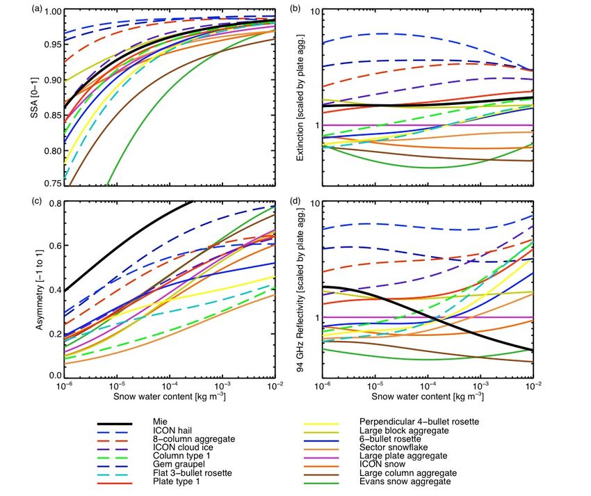
Optical
properties of
hydrometeors
in RTTOV-
SCATT: at
183 GHz

Lookup tables for
snow hydrometeors
as a function of
snow water content

 Geer et al. (2021, GMD, submitted) 16
 EUROPEAN CENTRE FOR MEDIUM-RANGE WEATHER FORECASTS
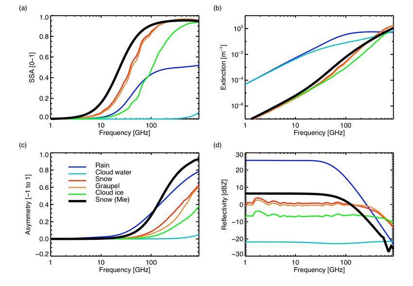
Optical
properties of
hydrometeors
in RTTOV-
SCATT:
across
frequencies

Lookup tables for
snow hydrometeors
of water content
10^-4 kg/m^3 as a
function of
frequency

 Geer et al. (2021, GMD, submitted) 17
 EUROPEAN CENTRE FOR MEDIUM-RANGE WEATHER FORECASTS
Wavelength
Cloud and 100 mm 10 mm 1 mm
precipitation Slab cloud at 283K
optical properties: above a 280K
the microwave surface (solid)
spectrum

 Slab cloud at 283K
 above a 100K
 surface (dashed)

 Geer et al. (2021, GMD, submitted)

 EUROPEAN CENTRE FOR MEDIUM-RANGE WEATHER FORECASTS 18
All-sky assimilation

 © ECMWF May 6, 2021
• Clear-sky assimilation:
Clear-sky or – Remove any cloud-contaminated observations
all-sky? – Do not model the effect of cloud on brightness temperatures
 – Traditionally used for temperature sounding channels (e.g. AMSU-A channel 5)
 – Extract small signals of temperature forecast errors (order 0.1K) that would be
 swamped by errors from displaced clouds and precipitation (10-100K)

 • All-sky assimilation
 – Model the effect of cloud and precipitation on the observations
 – Assimilate all data, whether clear, cloudy or precipitating
 – Initially developed for water-vapour sounding and imaging channels
 – Use the tracing mechanism of 4D-Var to infer the dynamical state from errors in
 the location/intensity of water vapour, cloud and precipitation

 • Forthcoming ECMWF cycle 47r3: AMSU-A will be assimilated in all-sky
 conditions
 – Now all but a handful of microwave sensors are assimilated in all-sky conditions
 – Broadly, clear-sky approach is now outdated at microwave frequencies

 EUROPEAN CENTRE FOR MEDIUM-RANGE WEATHER FORECASTS 20
Impact of satellite
radiances by
sensor (100% = all
obs)

After moving
AMSU-A to all-sky
(future 47r3 config.)

 21
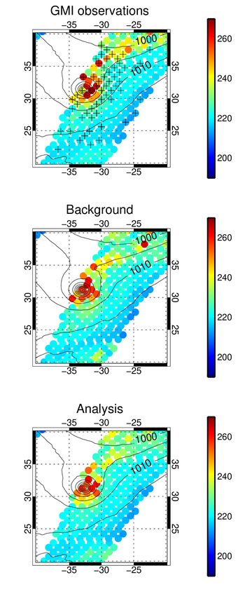
Time of
 Start End
All-sky Assimilation window observation (08Z)

‘tracer’ effect
Single 190 MSLP and
GHz snow
observation
 column
assimilation
test case (FG)

 Snow
 column
 increment
 Snow reduction at observation time generated by reduction
 in strength of low pressure area 1000km away, 11h earlier

 MSLP
 increment

 EUROPEAN CENTRE FOR MEDIUM-RANGE WEATHER FORECASTS 22
All-sky microwave imagers: a unique contribution from precipitation-
affected observations

 Microwave imagers give their largest forecast impact
 from a small fraction of precipitating scenes.

 AMSR2, July-August 2016

 EUROPEAN CENTRE FOR MEDIUM-RANGE WEATHER FORECASTS 23
GMI contributes to improved forecasts of hurricane / cyclone Leslie (2018)
GMI observations at 24 GHz
06 UTC, 12-Oct-2018 Forecast from 11th
 TB [K] October, 12 UTC is
 incorrect - Leslie’s
 “+” are position is around
 particularly 1000km out
 beneficial
 observations
 according to
Background FSOI Forecast from 12th
 October, 00 UTC is
 simulated correct – Leslie hits
 from model Portugal overnight on
 13-14th October
 Data assimilation
 shifts the cyclone
 • Long-lived Atlantic hurricane Leslie transitioned to an extratropical storm and brought strong winds, heavy
 centre 60 km rain and flooding to Portugal, Spain and France.
Analysis towards Portugal
 • Forecasting the landfall in Portugal remained challenging 60 hours ahead but the 48 hour forecast began to
 (almost invisible capture the true evolution of the storm.
 at this scale), and
 • On this occasion, GMI was in the right place to give the biggest satellite contribution to the improved forecast
 triggers more
 (drifting buoys contributed significantly more, but were the only observation giving more impact than GMI).
 rapid and more
 • Forecast Sensitivity to Observation Impact (FSOI) shows GMI on average contributes around 1.3% to the
 NE movement of
 24h forecast quality at ECMWF. Around 28 satellite radiance sensors are assimilated overall, along with
 the cyclone many other types of observation, all of which contribute at one time or another.
 • GMI all-sky radiances are assimilated over ocean from channels 19v, 19h, 24v, 37v, 89v, 183±3 and 183±7
 EUROPEAN CENTRE FOR MEDIUM-RANGE WEATHER FORECASTS 24
Geer (2021, submitted to AMTD):
Parameter estimation for 6 macro- and microphysical variables Physical characteristics of frozen
 hydrometeors inferred using
 parameter estimation

 Costfunction at
 original config.
 at best config.

 EUROPEAN CENTRE FOR MEDIUM-RANGE WEATHER FORECASTS 25
2. Active
 1. Microwave radar .
6. Earth 5. Solar T-sounding low- high-freq. ud ecip dar 3. Sub-mm 4. Infrared
 o r Li
radiation Cl P
budget Cloud Cloud ice Cloud fraction,
 particles, water cloud top
 lighter height, multiple
 precip. Ice particle layers
 size, shape,
 orientation
 Vertically Larger Vertically
 resolved frozen resolved
 particles,
 particle
 Cloud size and
 particle Size of water
 Cloud shape cloud particles
 size and liquid
 number water
 9. Lightning
 Melting
 particles

 Cloud Sub-FOV Rain, including
 cover heterogeneity particle size
 & structure

 7. Rain gauge 8. Ground radar
Questions?

 EUROPEAN CENTRE FOR MEDIUM-RANGE WEATHER FORECASTS 27
You can also read