New High-Altitude GPS Navigation Results from the Magnetospheric Multiscale Spacecraft and Simulations at Lunar Distances - NASA
←
→
Page content transcription
If your browser does not render page correctly, please read the page content below
https://ntrs.nasa.gov/search.jsp?R=20170010351 2018-11-10T15:28:46+00:00Z

Goddard Space Flight Center

         New High-Altitude GPS Navigation Results from the
            Magnetospheric Multiscale Spacecraft and
                  Simulations at Lunar Distances

                   Luke Winternitz*, Bill Bamford**, Sam Price*
                              *NASA Goddard Space Flight Center
                              **Emergent Space Technologies, Inc.

                                    ION GNSS+ 2017
                                      Portland, OR
                                   September 28, 2017

                                                                                                                          1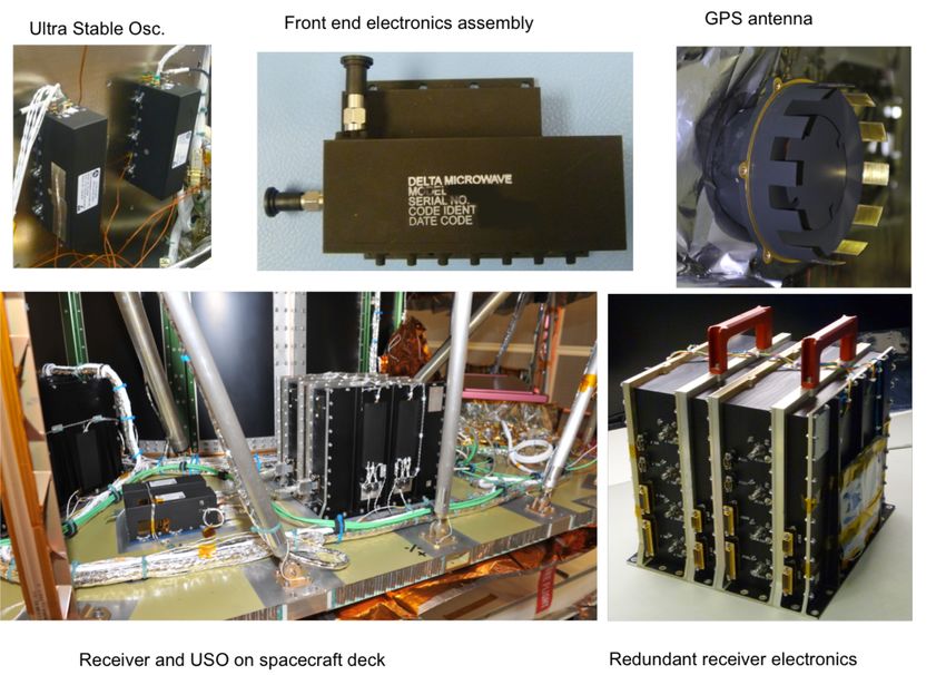
Outline
  Goddard Space Flight Center

l Background
   n High altitude GPS
   n Magnetospheric Multiscale (MMS) Mission
   n GPS Navigation for MMS
           • MMS Mission
           • MMS Navigation system
l New results from MMS Phase 2B
l Simulations at Lunar distance
   n Calibration on MMS Phase 2B
   n MMS extended mission concept
   n Concept Lunar trajectory
l Conclusion

                                               2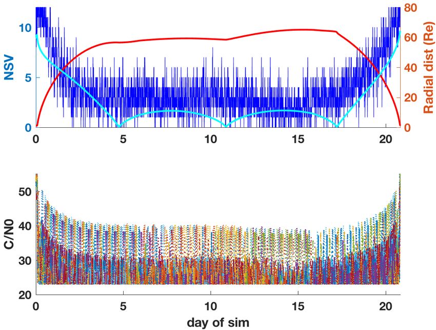
Background on high-altitude (HEO) GPS
    Goddard Space Flight Center

l HEO GPS navigation offers performance and cost improvements, but poses
  challenges
   n Sparse mainlobe availability, sidelobes weak, unspecified/uncharacterized, poor
      geometry, potentially harsher radiation environment.
l Ongoing research in HEO GPS R&D since 1990’s, GSFC among leaders
     n Numerous simulations studies at GEO, HEO, even Lunar distances
     n GSFC led effort to define/expand GPS Space Service Volume definition and characterize in-
       situ GPS transmitter antenna patterns (GPS-ACE 2015)
     n Developed Navigator HEO GPS receiver
                                                                           High-altitude GPS
l Early on-orbit experiments in late 1990’s-early 2000’s
     n   AFRL Falcon Gold, TEAMSAT, EQUATOR-S
     n   NASA GSFC / AMSAT OSCAR-40, 2000
l Recent growth in available receivers/applications, e.g.,
     n   GD Monarch flying on USG SBIRS (GEO) (~2011-2012)
     n   Surrey Satellite SGR-GEO experiment on GIOVE-A (2013)
     n   Airbus/Astrium MosiacGNSS and LION GNSS Rx for HEO
     n   Moog-Broad Reach Navigator (AFRL ANGELS 2015, EAGLE 2017)
     n   RUAG Podrix to fly on ESA Proba-3 (2018)
     n   General Dynamics’ Viceroy-4 flying GOES-16 at GEO (2017)
     n   NASA GSFC Navigator GPS flying HEO MMS since 3/2015

l   MMS set records for highest (and fastest) GPS receiver operations to date
                                                                                                   3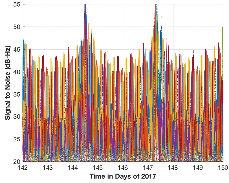
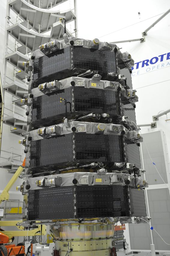
Magnetospheric Multiscale Mission (MMS)
    Goddard Space Flight Center

l Discover the fundamental plasma physics process
  of reconnection in the Earth’s magnetosphere.
l Coordinated measurements from tetrahedral
  formation of four spacecraft with scale sizes from
  400km to 7km
l Flying in two highly elliptic orbits in two mission
  phases
   n Phase 1 1.2x12 RE (magnetopause)
   n Phase 2B 1.2x25 RE (magnetotail)
            (For reference GEO ~6.5 RE, Moon ~60 RE)

                                                        4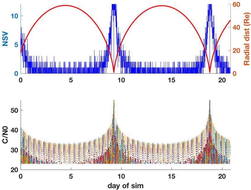
MMS Navigation System
    Goddard Space Flight Center

l   MMS Navigation system consists of Navigator GPS receiver, with Ultra-stable crystal
    oscillator and Goddard Enhanced Onboard Navigation Software (GEONS)
l   Navigator-GPS
      n   Product of NASA Goddard project to build high-altitude GPS receiver (~2001)
      n   Rad-hard C/A code receiver, with fast unaided weak signal acq (
MMS Navigator GPS hardware
   Goddard Space Flight Center

l GPS hardware all developed and tested at GSFC. Altogether, 8 electronics
  boxes, 8 USOs, 32 antennas and front ends

                                                                             6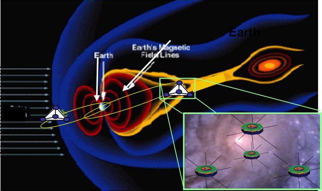
On-orbit Phase 2B results:
           Goddard Space Flight Center
                                            signal tracking
                                                                                                   C/N0 vs. time, near apogee
l Consider 8-day period early in Phase 2B
l Above GPS constellation, majority of
  signals are still sidelobes
l Long term trend shows average of ~3
  signals tracked near apogee, with up to 8
  observed.
l Visibility exceeds preflight expectations
  significantly

                                      Signals tracked

                                                                          25
                       12

                       10                                                 20
                                                                               Orbit Radius (Re)
  Satellites tracked

                        8
                                                                          15

                        6
                                                                          10
                        4

                                                                          5
                        2

                        0                                                 0
                        142   143   144   145   146   147   148   149   150
                                     Time in Days of 2017                                                                       7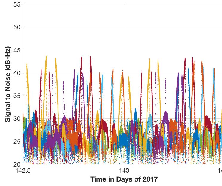
On-orbit Phase 2B results:
           measurement and navigation performance
  Goddard Space Flight Center

l GEONS filter RSS 1-sigma formal errors
  reach maximum of ~50m and briefly 5mm/s
  (typically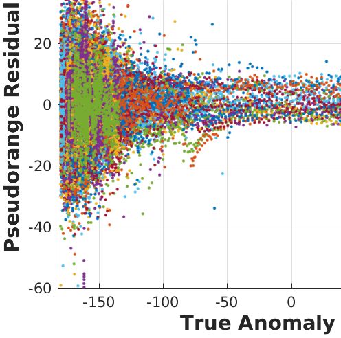
Simulations
    Goddard Space Flight Center

l   Wanted to “get a feel for” performance of MMS Navigation system in:
     1. A concept MMS extended mission orbit with apogee raised to 60 RE
     2. A concept Lunar trajectory
l   Ran “quick” GEONS ground simulations using new flexible MATLAB based GEONS
    simulation architecture using GEONS-Datagen GPS data simulation
     n Very similar approach to MMS preflight analysis, but with link models recalibrated based on
        on-orbit observations in Phase 2B
          • Model MMS GPS receiver
             performance
          • Run GEONS FSW as
             configured for MMS
     n Simulation used higher order
        dynamics than filter, but included
        some simplifications
             •   None or impulsive burns
             •   No SRP or drag
      n Ran one case for each trajectory
        considered
             •   Examined visibility, tracking
                 performance, filter formal and
                 actual errors

                                                                                                     9
MMS2B calibration
    Goddard Space Flight Center

l   Propagated initial state from flight data, same period as flight data plots
l   Used GEONS-Datagen, with representative GPS Block IIR and IIRM 2D transmit antenna
    patterns obtained from www.gps.gov, to simulate signals (used IIRM for IIF also)
l   Compared signals tracked and C/N0 simulated vs. flight and adjusted receiver loss and
    GPS transmit power slightly per-block to line up
l   Ran filter, looked at performance and compared to flight results (signals tracked, C/N0
    arcs, filter formal errors)
l   Obtained a close qualitative match for all metrics
     n Did not model GPS transmitter yaw: sidelobe arcs don’t match exactly
     n Randomness in acquisition model prevents exact match

                                                                                              10
Concept MMS extended mission performance
Goddard Space Flight Center
l How will MMS-Nav perform if they raise apogee to 60 RE in extended mission?
l Propagated MMS4 initial state for 20+ days using “truth dynamics,” no maneuvers
l Use identical GEONS-Datagen configuration as in calibration, and similar filter config
n plus some extra process noise near perigee
l Split errors in range/lateral direction
n Range/clock errors become highly correlated and dominate total position error, performance
limited by clock instability.
Signals tracked and radial dist (top); C/N0 (bottom) Filter position formal (3σ) and actual errors
11Concept Lunar mission
Goddard Space Flight Center
l How will MMS-Nav perform if used on a conceptual Lunar mission with 14dBi high-gain?
n GSFC internal research project aims to develop such an antenna
l Used concept Lunar trajectory:
n LEO->translunar->Lunar (libration) orbit->return
l Use identical GEONS-Datagen configuration as in calibration, and similar filter config:
n extra process noise near moon
n high-gain switched on at 12RE
l Visibility similar to MMS2B, as high-gain makes up for additional path loss
l Again, range/clock-bias errors dominate
n With atomic clock, or, e.g., periodic 2-way range/Doppler, could reduce range errors to meas. noise level
Signals tracked and radial dist to Earth (red) Filter position formal (3σ) and actual errors
and Moon (cyan) (top); C/N0 (bottom)
12Conclusion
Goddard Space Flight Center
l High altitude GPS is now a proven technology that can reduce operations costs
and even enable missions like MMS (and GOES-16 now)
n Applications and receiver availability expanding rapidly
l MMS currently in Phase 2B orbit at 25Re (40% to moon) navigating onboard
with GPS using GSFC-Navigator receiver + GEONS filter software
n Highest (and fastest) operational use of GPS (already was case in Phase 1)
n Onboard navigation significantly out-performing requirements
n Signal visibility throughout Phase 1 and even Phase 2B orbit is excellent
n Sidelobe signals appear to be of “navigation quality”
l Conducted simulations to predict MMS-nav system performance on two
concept trajectories reaching Lunar distances
n Receiver should continue to perform very well for MMS extended mission
n MMS-nav system with high-gain could offer strong onboard navigation
performance for future Lunar exploration or habitation missions
l High-altitude GPS navigation performance will only get better with new GNSS
systems, signals, and receiver tech, but we believe useful onboard GPS
navigation at Lunar distances is achievable now using currently available
signals and flight proven receiver technology
13You can also read