Autonomous Navigation challenges in the design of certification procedures in Autonomous Driving - Alberto Fernández Wyttenbach Market Development ...
←
→
Page content transcription
If your browser does not render page correctly, please read the page content below
Autonomous Navigation challenges in the design of
 certification procedures in Autonomous Driving
                Alberto Fernández Wyttenbach
         Market Development - European GNSS Agency
            HEADSTART Workshop, 13rd September 2019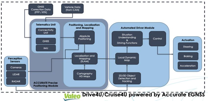
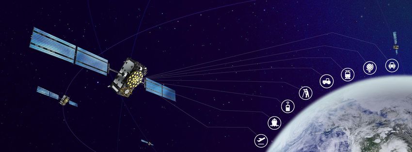
Galileo is used today in the majority of professional
devices and consumer platforms
+1,000 Mill. Galileo devices as of today
e112 Regulation (EU) mandates
Galileo in emergency
communications from mobile
devices from 2022
eCall regulation (EU) mandates 3 Million vehicles
Galileo in every new type of (end-2019)
car/van sold in Europe from
April 2018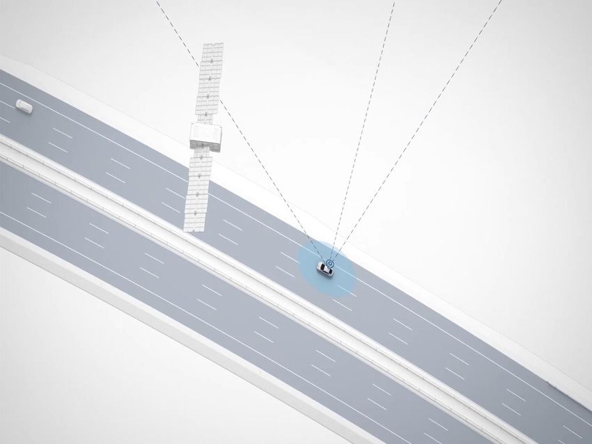
Galileo Open Service improves positioning
          performance WORLDWIDE for FREE

Multiple GNSS: more satellites      Multiple frequencies remove
  visible in harsh environment     ionospheric errors and mitigate
(urban canyons, tree canopy,...)        multipath reflections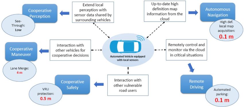
Operational functions in CCAM include (Autonomous) Navigation

                                                   Source: Ericcsson – 5GCAR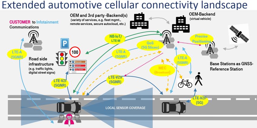
Industrial similarities in the design of Autonomous Navigation
INS Human-machine interface (HMI): The HMI
Satellite positioning based on
“Valeo Drive4U®, the first autonomous car to
Odometry/SLAM multi-frequencies & multiconstellations refers to the combination of systems in the interior of
HAD maps receivers, hybrid RTK-PPP corrections. be demonstrated on the
the vehicle, including thestreets of Paris”
infotainment/entertainment
system, instrument panel, and controls that act as an
Map matching interface between the car and the occupants.
Dead reckoning Visual Cameras: Apart from object
detection, cameras can be used for various Black Boxes are sophisticated event data
… other applications, including reading speed limit recorders in the event of an accident or failure
signs, headlight high beam de-activation in case
(level 5) of an approaching vehicle, light sensing, etc.
Artificial Intelligence: Radar and Ultrasonic Sensors: the car
2 way communication: reliable, high-speed
two-way data communications equipment for
- Machine Learning also collects images using short-range and long-
navigation and V2V/V2I communication for
- Deep Learning range sensors, to understand what is happening
synchronization. This will include antennas and 4G/5G.
with the car itself.
- Big data analytics
Augmented Reality LIDAR uses a combination of reflected Software/domain controller: the “brain”
laser/light (LI) and radar (DAR) to create a 3D of the autonomous system. It receives signals from
profile of the surroundings of the car. The cost of the cameras, radar, sensors…, and determines what
Natural Language Processing LIDAR has decreased over time, but it is still the
most expensive sensor
action is to be taken and then communicate it.
Source: Morgan Stanley
Main challenges in relation to Navigation Technology
                                            Contribution of Galileo High Accuracy

                               “GNSS is essential for the automated cars
                               industry. Being able to determine the
                               position of vehicles will enable predicted
                               driving and increase security”
                               “The positioning accuracy of 20 cm from
                               Galileo will be essential in urban areas”
                                     Joost Vantomme, Director in the European Car
                                                Manufacturers Association (ACEA)     * Source: EuroActiv, December 2018

                                                                                    Source: Deutsche Telekom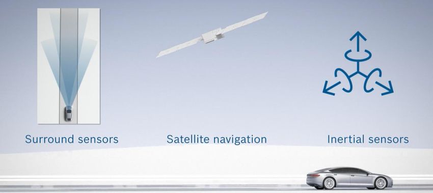
Main challenges in relation to Navigation Technology
                                  GNSS Integrity/High Accuracy corrections via 5G

                                                                  Source: Deutsche Telekom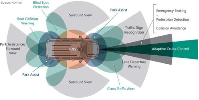
Main challenges in relation to Navigation Technology
                                  GNSS Integrity/High Accuracy corrections via 5G

                                                                        Source: Bosch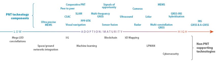
Main challenges in relation to Navigation Technology
NON-INTENTIONAL INTERFERENCES (SPECTRUM)
CEPT-ECC confirmed high-power IMT base stations in the
1492-1517 MHz band might impact the GNSS L-band (1559-
1610 MHz) and will be interference in the commercial mobile-
satellite service (MSS) bands which lies between 1525-1559
MHz (between IMT and GNSS L-band).
This is relevant for 5G Space services for Connected Cars.
FCC is investigating the waiver for the new UltraWideband
(UWB) technology for autonomous vehicles. UWB ground-
penetrating radar system will peer beneath the surface of a
road to map the features under the pavement.
Main challenges in relation to Navigation Technology
INTENTIONAL INTERFERENCES (CYBER ATTACKS)
EU Cybersecurity Act entered into force in 27 June 2019
NIS Directive: Transport OES (road authorities, ITS operators)
ENISA study on Cyber Security and Resilience of Smart Cars
GNSS Authentication provides a secure and reliable location,
by detecting interference (spoofing) attacks
The UNECE World Forum for automotive regulations
declared the need of clear cybersecurity rules:
GNSS authenticated message is recommendedMain challenges in relation to Navigation Technology
Different state of maturity for PNT and non-PNT technologies (complementarity is always needed!)Status of European standards today
Development of base standards in relation on C-ITS EN 16803: Use of GNSS-based positioning
Secure Communications and VRU: for road Intelligent Transport Systems (ITS)
Part 1: Definitions and system engineering
CEN/ISO TS 21176: Cooperative ITS – procedures for the establishment and
Position, Velocity and Time service in assessment of performances: overall framework
the ITS station and operational procedures for the establishment
of GNSS-based performances for ITS
ETSI TS 103 300: Intelligent Transport Part 2: Assessment field tests for basic
Systems – Vulnerable Road Users performances of GNSS-based positioning
terminals: testing procedures to assess the basic
performances (Availability, Accuracy and Integrity)
GNSS authentication will be widely used in urban
mobility services, which require trustability: Part 3: Assessment field tests for security
performances of GNSS-based positioning
terminals: testing procedures to assess the
ETSI TS 103 246: Satellite Earth Stations and performances submitted to RF attacks such as
Systems; GNSS based location systems: Functional spoofing or jamming
requirements, Reference architecture, Performance
Part 4: Methodology for the recording of
requirements relevant data sets (Record & Replay): define the
way the data files are built and validatedConclusion (I): Technology is overcoming the main challenges, supported
by standardized designs and industry/infrastructure innovation
GNSS is crucial to get decimetre/centimetre-level The UN World Forum for automotive
absolute location and timing synchronization in regulations declared the need of clear
combination with inertial navigation, odometry, HD cybersecurity rules, and GNSS authenticated
maps, Machine-Learning and Artificial Intelligence. messages are recommended.
High Accuracy service will bring a Authentication service will detect
decimeter level error (≈20cm): interference (spoofing) attacks:
based on the Galileo E6b signal Source: Galileo E1 Navigation Message Authentication
Continental
Galileo E6 Spreading Code Authentication
BMW and General … and the key European car makers (Mercedes-Benz, Fiat-Chrysler,
Motors/Cadillac autonomous
Scania, Renault, Volkswagen, Volvo…) confirmed the interest to test
vehicles models expected
in 2021 will be Galileo compatible
the Galileo High Accuracy and Authentication once availableConclusion (II): (Autonomous) Navigation is a Safety function!
20
cm
WP.29 / GRVAAutonomous Navigation challenges in the design of
certification procedures in Autonomous Driving
Alberto Fernández Wyttenbach
Market Development - European GNSS Agency
HEADSTART Workshop, 13rd September 2019You can also read