TRANSPORTATION MANAGEMENT PLAN (TMP) - OR99E: American Drive to South City Limit (Halsey) Key #18751 - Oregon Department of Transportation Region ...
←
→
Page content transcription
If your browser does not render page correctly, please read the page content below
TRANSPORTATION MANAGEMENT PLAN (TMP)

OR99E: American Drive to South City Limit (Halsey)

                    Key #18751

                      Prepared for:

              Oregon Department of Transportation
              Region 2

                       Prepared by:

                  2100 SW River Parkway
                  Portland, Oregon 97201
                        503.223.6663
TABLE OF CONTENTS Page
1 INTRODUCTION............................................................................................................. 2
2 PROJECT DESCRIPTION/BACKGROUND ............................................................... 2
3 PROJECT BOUNDARIES .............................................................................................. 2
3.1 ROADWAY CHARACTERISTICS ............................................................................... 3
3.3 LOCATION OF OTHER CONSTRUCTION PROJECTS ........................................... 4
3.4 HOLIDAYS AND SPECIAL EVENTS .......................................................................... 4
4 CONSTRUCTION STAGING & TRAFFIC CONTROL............................................. 4
5 TRAFFIC MITIGATION MEASURES ......................................................................... 6
5.1 PUBLIC INFORMATION AND OUTREACH STRATEGIES ...................................... 7
APPENDIX A .......................................................................................................................... 7
APPENDIX B ........................................................................................................................ 15
LIST OF FIGURES Page
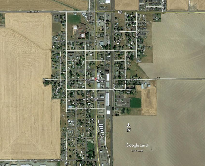
Figure 1 - Vicinity Map............................................................................................................. 3
Transportation Management Plan for OR99E: American Drive to South City Limit (Halsey)
May 4, 2021 Page 11 INTRODUCTION This Transportation Management Plan (TMP) aims to address traffic impacts and identify operation strategies to be implemented during the OR99E: American Drive to South City Limits (Halsey) project construction. It also provides details behind the development of traffic mitigation measures that would be in place for construction to minimize disruptions to travelers and freight without compromising public or worker safety and the quality of the work being performed. The TMP should be considered a living document subject to additions and modifications throughout the life of the project. 2 PROJECT DESCRIPTION/BACKGROUND The project is located in the City of Halsey, Oregon, along OR99E from the intersection at American Drive to the southern city limits. The purpose of this project is to address the poor conditions of the existing concrete panels and aggregate base, repair inadequate drainage facilities, and update ADA facilities that do not meet existing standards. 3 PROJECT BOUNDARIES The boundaries of this project include OR99E from M.P. 18.97 to 20.22 as shown in Figure 1 below. Minor work areas will connect to facilities off of OR99E, including driveway and side street connections, the realignment of Crowell Lane, and drainage work north of American Drive to MP 18.97. The project area is within the City of Halsey and Linn County. Transportation Management Plan for OR99E: American Drive to South City Limit (Halsey) May 4, 2021 Page 2
Figure 1 - Vicinity Map

3.1 Roadway Characteristics1
Within the project area, the Albany to Junction City Highway (OR99E) has an ADT range of
2501 – 5000 according to TransGIS. According to the 1999 Oregon Highway Plan (OHP), the
Albany to Junction City Highway (OR99E) is classified as a Regional Highway. It is listed as
an OHP Freight Route, and is listed as a Reduction Review Route according to the ODOT
Reduction Review Routes state map. OR99E runs primarily north-south from Albany at the
north end to Junction City at the south end.

From 2018 Google Earth imagery, OR99E is a two-lane facility with one through lane in each
direction from the north end of the project to north of C St. The imagery shows OR99E is a
three-lane facility with one through lane in each direction and a center left turn lane from C St.
to J St. OR99E is two lanes south of J St. through the end of the project.

1   Information from ODOT TransGIS webpage

Transportation Management Plan for OR99E: American Drive to South City Limit (Halsey)
May 4, 2021                                                                             Page 3
The posted speed limit is 35 mph from the north end of the project area to Crowell Lane, and
increases to 45 mph at Crowell Lane through the south end of the project area. The intersection
of American Drive and OR99E is four-way stop controlled with flashing beacons. All other
intersections within the project area are two-way stop controlled, with OR99E traffic being
uncontrolled.

There is existing sidewalk on the west side of the highway from the intersection of American
Drive to J Street. There is existing sidewalk on the east side from F Street to J Street. There is
a 5’ bike lane on the west side of OR99E, and a 6’ bike lane on the east side of OR99E. Both
bike lanes run from American Drive to J Street.

3.2      Work Zone Lane Restrictions

After the work zone traffic analysis was completed, the following was determined:

      1. Weekdays, one lane may be closed as follows:

              a. North of American Drive (MP 19.30) to north of J Street (MP 19.83): no lane
                 closures from 2:00 PM and 6:00 PM.

              b. North of J Street (MP 19.83) to north of Seefeld Drive (MP 20.22): no lane
                 closure restrictions

      2. Weekend:

              a. No lane closures between Friday 12:00 PM and Sunday 7:00 PM for the entire
                 project area.

3.3 Location of Other Construction Projects
To minimize construction impacts for traffic traversing the project area on OR99E and
surrounding roadways, this project may be coordinated with additional projects in the vicinity
of the project site. There are no known projects that will be under construction at the same time
as this project that will impact traffic in the project area.

3.4 Holidays and Special Events
Traffic within the area may be impacted by holidays and local special events. Single lane
closures will not be allowed during holidays or special event days. The major holidays are
included in the ODOT standard specifications. Local special events that may create an
increased burden on the project area include:

      - World Athletic Championship July 13 – 26, 2022

4 CONSTRUCTION STAGING & TRAFFIC CONTROL
Traffic Control Staging:

Standard drawings will be used to the furthest extent possible for the roadway work. In the
areas of pavement reconstruction, both ACP and PCC, work will be staged to construct one
half of the roadway at a time (total length approximately 4700’ long). The posted speed from

Transportation Management Plan for OR99E: American Drive to South City Limit (Halsey)
May 4, 2021                                                                             Page 4
North of American Drive (MP 18.97) to Crowell Lane (MP 19.89) is 35 mph, and the posted
speed from Crowell Lane (MP 19.89) to southern project limits (MP 20.22) is 45 mph.
In sections where there is ACP work standard drawings are anticipated to be used similar to
paving operations shown on TM 850, including flagging.
In sections where PCC full depth reconstruction will occur, it is anticipated that the roadway
width is 52’. A traffic control plan has been prepared that will provide 22’ minimum paved
width for two-way traffic in all Stages and Phases. This width is adequate for two 10’ travel
lanes with 1’ shy distance, or one 12’ travel lane with one 4’ buffer and one 3’ buffer. Each
travel lane would serve a mix of vehicular and bicycle traffic during construction.
The two 10’ travel lane plus two 1’ shy distance will provide up to 20’ to accommodate
advanced notice oversized loads with flaggers. As noted above, traffic will be delineated
using concrete barrier to protect the traveling public from the hole created by full-depth
pavement repair. Supplemental traffic control devices (drums, barricades, and tubular
markers) will be added as needed. A temporary speed reduction of 10 mph will be requested
to reduce the posted speed to 25 mph for existing 35 mph speed zone, and to reduce the
existing 45 mph zone to 35 mph posted speed.
The construction sequence anticipated for the paving includes four stages.
Stage I, Phase 1 (MP 18.97 - MP 19.33):
- ACP shoulder paving and drainage work. No width restrictions. Estimated duration
7 weeks. Two travel lanes available for duration of Phase.
Stage I, Phase 2 (MP 19.33 - MP 19.65):
- Single lane closure of NB lane. Restricted to 17' wide loads, wider loads may be
accommodated on a case-by-case basis with advanced notice. Estimated duration 7
weeks. Singe lane for two-way traffic. Weekdays, no lane closures 2 pm to 6 pm.
Stage II, Phase 1 (MP 18.97 - MP 19.33):
- ACP shoulder paving and drainage work. No width restrictions. Estimated duration
7 weeks. Two travel lanes available for duration of Phase.
Stage II, Phase 2 (MP 19.33 - MP 19.65):
- Single lane closure of SB lane. Restricted to 18' wide loads, wider loads may be
accommodated on a case-by-case basis with advanced notice. Estimated duration 7
weeks. Singe lane for two-way traffic. Weekdays, no lane closures 2 pm to 6 pm.
Stage III, Phase 1 (MP 19.65 - MP 19.85):
- Single lane closure of NB lane. Restricted to 11' wide loads, wider loads may be
accommodated on a case-by-case basis with advanced notice. Estimated duration 7
weeks. Two travel lanes available for duration of Phase. Road closures on F, G, I, and
J streets east of OR99E.
Stage III, Phase 2 (MP 19.65 - MP 19.85):
- Single lane closure of SB lane. Restricted to 11' wide loads, wider loads may be
accommodated on a case-by-case basis with advanced notice. Estimated duration 7
weeks. Road closures on F, G, I, and J streets west of OR99E.
Stage IV, Phase 1 (MP 19.85 - MP 20.22):
Transportation Management Plan for OR99E: American Drive to South City Limit (Halsey)
May 4, 2021 Page 5- Temporary paving on SB shoulder. Restricted to 14.5' wide loads, wider loads may
be accommodated on a case-by-case basis with advanced notice. Estimated duration 7
weeks.
Stage IV, Phase 2 (MP 19.85 - MP 20.22):
- Single lane closure of NB lane. Restricted to 11' wide loads, wider loads may be
accommodated on a case-by-case basis with advanced notice. Estimated duration 7
weeks. Road closure on J street east of OR99E.
Stage IV, Phase 3 (MP 19.85 - MP 20.22):
- Single lane closure of SB lane. Restricted to 11' wide loads, wider loads may be
accommodated on a case-by-case basis with advanced notice. Estimated duration 7
weeks. Road closures on J and O streets west of OR99E.
Stage IV, Phase 4 (MP 19.85 - MP 19.96):
-Sidewalk and drainage work. No width restrictions. Estimated duration 7 weeks.
TPAR:
Temporary Pedestrian Access Routes will use ODOT standard details wherever existing
facilities provide a level equal to or greater than facilities being closed. Detours will
primarily route pedestrians across OR99E, past the work zone, and back across OR99E.
Detours will in some cases route pedestrians one block away (such as through a park) but
stay parallel to OR99E.
At the intersection of American Dr. and OR99E, pedestrian facility construction will be
staged to allow access to three of the four corners at all times. Specific details for these
corners are found in the EA sheet series.
American Drive to North of F Street:
Stage 1 (east side) north of F Street: Existing pedestrian facilities on the west side of the
highway will remain open. Pedestrians will be crossed to the west side and routed around the
work zone before returning to the east side to continue their travels. There are no existing
pedestrian facilities on the east side where work will be done in Stage 1. For details of
pedestrian routes at each block, refer to TPAR sheets located in the EA sheet series.
Stage 2 (west side) north of F Street: Pedestrians will be shifted to the newly constructed
pedestrian facilities on the east side of the highway around active work zones on the west
side. For details of pedestrian routes at each block, refer to TPAR sheets located in the EA
sheet series
F Street to J Street:
There are existing pedestrian facilities on both sides of the roadway in this section.
Pedestrians will be directed to cross OR99E to use the sidewalk on the under-traffic side of
the roadway and then directed to cross back on the far side of the work zone. Standard
drawings will be used as much as possible for TPAR and will be supplemented by TPAR in
the EA series sheets when necessary.
5 TRAFFIC MITIGATION MEASURES
Transportation Management Plan for OR99E: American Drive to South City Limit (Halsey)
May 4, 2021 Page 6To help meet the performance goals for congestion management and promote work zone safety, a range of traffic management strategies were considered for implementation. The Work Zone Decision Tree (Appendix B) and the Mobility Considerations Checklist (Appendix A) forms were used in the development of the traffic control strategy. The decision tree form helps identify separation options available for the work zone and captures impacts to safety, mobility, delay, driver and bicycle/pedestrian convenience, and other impacts when assessing traffic control options. The mobility considerations checklist form helps to ensure all elements of traffic control have been examined, and checks that all groups affected by construction have been considered. 5.1 Public Information and Outreach Strategies Public information and outreach is beneficial for maintaining public support for projects, as well as for encouraging changes in travel behavior during construction. Making the public aware of the potential delays incurred while traveling through the project area or detour routes may encourage motorists to use alternate routes or plan trips to avoid peak construction activity times. This has potential to help manage congestion within the project area. The City of Halsey and ODOT will be coordinating to keep the public informed. The agencies will be utilizing social media platforms and paper mailings as well as the project web page to communicate. Transportation Management Plan for OR99E: American Drive to South City Limit (Halsey) May 4, 2021 Page 7
Appendix A

    Mobility Considerations Checklist

Transportation Management Plan for OR99E: American Drive to South City Limit (Halsey)
May 4, 2021                                                                             Page 7
Appendix B
Work Zone Decision Tree
Transportation Management Plan for OR99E: American Drive to South City Limit (Halsey)
May 4, 2021 Page 15You can also read