Charging for Transport in Guildford - Guildford Society Transport Group May 2021 DRAFT For Consideration
←
→
Page content transcription
If your browser does not render page correctly, please read the page content below
Charging for Transport in
       Guildford.
   Guildford Society Transport Group May 2021
             DRAFT For Consideration
Background
• This slide pack is a Draft of ideas being considered by
the Society
• Guildford has to address the following
• Car Dependency impacting centre of the Town and
constraining options for development.
• Guildford also needs to be mindful of congestion in the centre
causing issues in surrounding villages e.g. Rat Running
• The Government is encouraging ‘Active Travel’ for
Environmental and Health Reasons.
• The UK Government is focussing spend on ‘Levelling Up’
which is likely to support little infrastructure investment in
the Guildford AreaTechnology provides opportunity.
• Charging for Transport has come a long way
• Dartford Crossing uses electronic Tokens and Automatic
Number Plate Recognition Cameras (ANPR).
• Oyster Cards in London provide seamless charging across
Buses, Trains, and Cable Cars.
• Freiburg, our twin town, has a travel card that covers Buses,
Trams, Short term car hire, Bike Hire etc.
• Tokens are used extensively on Roads for Charging e.g.
France, USA etc.A sign of the Times. Highways England continue to design major capacity and safety enhancements such as at Junction 9 on M3 near Winchester, to ensure that the route between the south coast ports and the Midlands has sufficient capacity to support both the local and national economy. They are also developing proposals along the A3 at Guildford as to how they can use travel demand management measures to seek to drive travel behaviour change and thereby contribute to improving air quality in and around Guildford and help to address the significant congestion problems that inhibit the local economy.
Enablers
• A integrated Bus service – use the Bus Back Better white
  paper as key driver Bus Strategy England 2021
  (guildfordsociety.org.uk)
• Cycleways – use latest standards as proposed in the
  government Standards for Cycling Infrastructure
  (guildfordsociety.org.uk)
• Rail funding for re-opening or improving lines
Be Bold
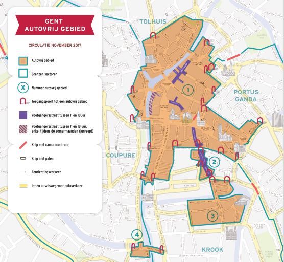
May Need to be Bold like Gent Why is the Circulation Plan
necessary?
Ghent is a vivid, vibrant and growing city. A busy city like Ghent has plenty of advantages but also
a number of challenges, because the pressure on the city keeps on growing. For that reason, the
city council has made some decisions ensuring that both citizens and visitors will get more space.
Ghent also needs to stay viable and accessible TOMORROW. That is why TODAY, the city council
has made decisions ensuring that citizens and visitors:
• Will get more space to enjoy Ghent;
• Will be able to move safely;
• Will be able to live, work and study in a healthy living environment;
• Will be able to easily reach their destination.
What is changing?
• The restricted traffic area/pedestrian area is going to be extended.
• The city center is going to be divided in 6 sections surrounding the restricted traffic area.
• Transit traffic on important roads will be prevented by closing streets for motorized
vehicles.
• There is a change of travel direction in various streets.
• The inner ring (R40) will get you from section to section.
• The main ring road (R4) will get you from municipality to municipality.
This way, there will be more space available for pedestrians, cyclists, buses and trams. Traffic
that really needs to be in the city, will easily reach their destination. Emergency services, public
transport, refuse collection vehicles (IVAGO), taxis and healthcare providers with permits,
(electric) bikes, cargo bikes and class A and B mopeds are allowed to pass through streets closed
for motorized vehicles.Gent has a sophisticated set up - for example 5 restricted traffic areas 17 different permit categories. • Not all permits will automatically grant access to all restricted traffic areas. A resident domiciled in one restricted traffic area won't automatically be able to drive through another restricted traffic area. However, access to different restricted traffic areas may be granted. • Suppliers with delivery addresses in multiple restricted traffic areas may request a permit for each restricted traffic area. Please be aware that supplying your customers within the restricted traffic area is only allowed from 6pm to 11am, with an exception of the restricted traffic area in Overpoortstraat, there access is allowed from 5am to 6pm. From paper to digital • Digital permits • Licence plate numbers of vehicles with a permit will be added to a digital list. The vehicles mentioned on this list are permitted to enter the restricted traffic area. Access control is done by ANPR-cameras. These camera's will scan you licence plate and check if your vehicle has been added to the digital list. Fixed entry points • A permit for a restricted traffic area will give access through all or a limited number of entry points. Each entry point has its own access control camera. Entering a restricted traffic area without a permit will result in a fine of 58 euro.
Principles for Guildford Traffic
Management?
• Recognise that a proportion of Transit Traffic e.g.
  Horsham to A3 or Bracknell needs to be allowed for as it
  avoids impacts on surrounding minor roads.
• Traffic from outside Guildford accessing Core Areas,
  Town Centre, Slyfield, and Research Park should be
  intercepted by high Quality Park and Ride Facilities.
• Within Town Traffic e.g. Merrow to Burpham should be
  discouraged and Active Travel and Bus/Train promoted
  instead.
Through Network
• Guildford cannot get rid of through traffic
• 2016 indicates roughly 20% is through traffic
• Through traffic if stopped may spill over into
  surrounding minor roads
• Strategy Allow, Charge modestly to provide some
  revenue, Charge to encourage movement outside peak
  hours, heavy charges incurred if timings indicate
  stopping within Guildford area.
Key Through routes
      Electronic Gate
Core Area Strategy • Probably three areas Town Centre, University-Research Park, Slyfield • Limit parking and encourage access by Park and Ride Active Travel, Public Transport. • High costs to access, with exceptions e.g. Delivery Vans • People living in core areas with allocated parking would have minimal charges to commute outside Guildford • Timing would allow Town Centre at low rates for evening economy
Core - Town Centre, University, Research Park, Slyfield
Urban Area Strategy
• Divide Town into Sectors
• Limit parking and encourage access by Park and Ride
  Active Travel, Public Transport.
• High costs to access, with exceptions e.g. Delivery Vans
• Minimal charges to commute outside Guildford
• Timing would allow Town Centre at low rates for
  evening economy
• Make it cost to move across Urban Sectors at certain
  times in the day e.g. discourage dropping children at
  school.
Urban Areas – Rough Example (Possible Inner and Outer
                                                  Core
             Zone A.1

                                         Zone B

            Zone A.2                                     Zone C

                                Zone F

              Core

                                         Core

                       Zone E                            Zone D
Repurpose Roads. • Farnham Road – make it a local access road, channel A31 via A3? • Stoke Road – Local Access and Bus Corridor? • Walnut Tree Close – Make local access and SMC with Yorkies Bridge rebuilt as access to University • Madrid Road, The Chase operate with Walnut Tree closed as bus route out of town?
Change Road Use
Parking
• Park and Ride Extensions
   • Shalford, Worplesdon/Slyfield
• Town Centre Car Parks discontinued
Matrix of Charges

               Core   Inner   Outer   External   Park   Transit
                                                 Ride
 Core                 £3      £2      £0         50P    NA
 Inner         £3     NA      £1      £0         50P    NA
 Outer         £2     £1      NA      £0         25P    NA
 External      £3     £2      £1      NA         £1     £1
 Park n Ride   NA     50P     25P     £1         NA     NA
 Transit       NA     NA      NA      NA         NA     £1
You can also read