2017 University of Central Florida Severe Weather Plan - UCF ...
←
→
Page content transcription
If your browser does not render page correctly, please read the page content below
2017
University of Central Florida
   Severe Weather Plan

                     UCF Office of Emergency Management

                               Current as of:
                              April 2017
UCF Severe Weather Plan                                       2017

                     This page is intentionally left blank.

                                                               Page 2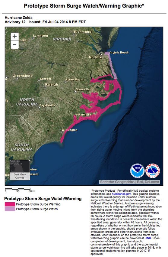
UCF Severe Weather Plan                                                                                                                  2017

TABLE OF CONTENTS
Chapter 1: INTRODUCTION ................................................................................9
  1.1. PURPOSE .............................................................................................................................. 9

  1.2. SCOPE .................................................................................................................................. 9

  1.3. STORMREADY UNIVERSITY .............................................................................................. 10

Chapter 2: SEVERE WEATHER ALERTS .......................................................11

  2.1 SEVERE THUNDERSTORM WATCH .................................................................................... 11

  2.2 SEVERE THUNDERSTORM WARNING ................................................................................ 11

  2.3 TORNADO WATCH ............................................................................................................. 11

  2.4 TORNADO WARNING.......................................................................................................... 12

  2.5 TROPICAL STORM WATCH ................................................................................................ 12

  2.6 TROPICAL STORM WARNING ............................................................................................ 12

  2.7 HURRICANE WATCH .......................................................................................................... 12

  2.8 HURRICANE WARNING ...................................................................................................... 12

  2.9 EXTREME WIND WARNING ............................................................................................... 12

Chapter 3: THUNDERSTORMS .........................................................................14
  3.1. GENERAL THUNDERSTORM INFORMATION ...................................................................... 14

  3.2. LIGHTNING ........................................................................................................................ 14

  3.3. FLOODING ......................................................................................................................... 15

Chapter 4: TORNADOES .....................................................................................17
  4.1. GENERAL TORNADO INFORMATION ................................................................................. 17

Chapter 5: TROPICAL WEATHER ...................................................................18

                                                                                                                                            Page 3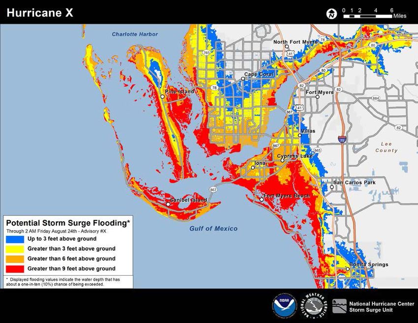
UCF Severe Weather Plan                                                                                                                2017

  5.1. GENERAL TROPICAL WEATHER INFORMATION............................................................... 18

  5.2. OTHER TROPICAL WEATHER PRECAUTIONS .................................................................. 19

Chapter 6: HIGH WINDS.....................................................................................22
  6.1. GENERAL HIGH WIND INFORMATION .............................................................................. 22

Chapter 7: EMERGENCY NOTIFICATION ....................................................23

  7.1. CAMPUS NOTIFICATION .................................................................................................... 23

  7.2. EXTERNAL NOTIFICATION ................................................................................................ 23

Chapter 8: MINIMUM ACTIONS TO BE TAKEN ..........................................24
  8.1 SEVERE THUNDERSTORM WATCH .................................................................................... 24

  8.2 SEVERE THUNDERSTORM WARNING ................................................................................ 24

  8.3 TORNADO WATCH ............................................................................................................. 24

  8.4 TORNADO WARNING.......................................................................................................... 24

Chapter 9: SEVERE WEATHER KIT................................................................25
  9.1. CONTENTS ......................................................................................................................... 25

Chapter 10: TRAINING AND PROGRAMS .....................................................26
  10.1 SEVERE WEATHER TRAINING ......................................................................................... 26

  10.2 SEVERE WEATHER PROGRAMS ....................................................................................... 26

Chapter 11: ADDITIONAL RESOURCES ........................................................27

  11.1. RADIO .............................................................................................................................. 27

  11.2. TELEVISION ..................................................................................................................... 27

  11.3. INTERNET ........................................................................................................................ 27

  11.4. OTHER RESOURCES ........................................................................................................ 27

                                                                                                                                          Page 4
UCF Severe Weather Plan                       2017

Appendix A: USER GUIDE FOR TROPICAL WEATHER
REPORT……29

                                               Page 5
UCF Severe Weather Plan                                       2017

                     This page is intentionally left blank.

                                                               Page 6
UCF Severe Weather Plan                                                                2017

This plan is maintained by the University of Central Florida Office of Emergency Management.
Any concerns or questions should be forwarded to, specifically:

Emergency Plans and Programs Coordinator
Office of Emergency Management
Phone: 407-823-0678

Department Responsible for this Plan:
   • Office of Emergency Management

Supersedes:
   • May 2015 Edition

Pages:
   • 83

Distribution:
   • Office of Emergency Management
   • UCF Police
   • General Distribution

Notes:
   • This plan is included in the Comprehensive Emergency Management Plan (CEMP),
       General Edition.
   • This plan has been reviewed by the National Weather Service, Melbourne Office.

                                                                                        Page 7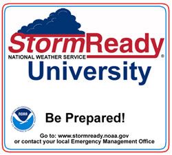
UCF Severe Weather Plan                                       2017

                     This page is intentionally left blank.

                                                               Page 8
UCF Severe Weather Plan 2017
CHAPTER 1: INTRODUCTION
1.1. Purpose
1.1.1. The purpose of this Severe Weather Plan is to provide a course of action to be used during
a severe weather event to minimize the potential for injury and loss of life that can result
during severe weather.
1.1.2. For further information on severe weather and severe weather preparedness, please refer to
the Office of Emergency Management (OEM) web site: www.emergency.ucf.edu.
1.2. Scope
1.2.1. This plan is designed to address response to severe weather situations during regular office
hours (8:00 a.m. – 5:00 p.m., Monday through Friday). Outside of regular office hours, the
University Police Department and Facilities Operations will monitor local weather and
notify OEM of potential severe weather where will they be responsible for assessing the
situation, briefing the Associate Vice President and Chief of Police (Administration and
Finance), and recommending appropriate actions.
1.2.2. Although the plan is primarily focused on the University of Central Florida’s (UCF) main
campus, it aims to include the regional campus locations as well.
1.2.3. The information contained in this plan has been obtained from guidelines from the National
Weather Service (NWS) and the National Oceanic and Atmospheric Administration
(NOAA).
1.2.4. It is recommended that UCF departments develop their own emergency severe weather
plans, detailing protective actions to be taken to prepare their offices and personnel for
severe weather events. For additional information on developing department plans, please
contact the OEM.
1.2.5. Based upon the UCF Threat and Hazard Identification and Risk Assessment (THIRA)
Plan, the University is vulnerable and susceptible to severe weather, and is considered a
primary natural hazard.
Page 9UCF Severe Weather Plan 2017
1.3. StormReady University
1.3.1. The University of Central Florida has recently been
awarded the recognition of becoming a StormReady
University by the National Weather Service. The
StormReady program helps communities, universities
and other organizations safeguard its people and
property from severe weather. It is recognized that
StormReady Universities are better prepared to save
lives through better planning, education, and
awareness. UCF partnered with the National Weather
Service, Melbourne office, to work on fulfilling the six
guidelines required to become a StormReady
University.
1.3.2. To be recognized as StormReady, a university must:
1.3.2.1. Establish a 24-hour warning point and emergency operations center;
1.3.2.2. Have at least four redundant systems in place to receive severe weather warnings
and forecasts at both the 24-hour warning point and the emergency operation
center;
1.3.2.3. Create a system that monitors local weather conditions and information on an
ongoing basis;
1.3.2.4. Have at least four redundant systems in place to notify the university community
of severe weather warnings;
1.3.2.5. Promote the importance of community preparedness through campus weather
seminars and training on an annual basis; and
1.3.2.6. Develop a formal hazardous weather plan for the entire campus and provide
Storm Spotter training classes, as well as hold emergency exercises.
1.3.3. The University submitted a preliminary application to the National Weather Service on
April 21, 2010. On May 18, 2010, a representative from the Melbourne office conducted
an on-site evaluation as part of the application process. UCF was informed that it was
approved for StormReady University designation on June 4, 2010.
1.3.4. UCF’s StormReady designation was renewed in 2013 and 2016, respectively. UCF’s
designation will remain valid until 2019.
Page 10UCF Severe Weather Plan 2017
CHAPTER 2: SEVERE WEATHER ALERTS
2.1 Severe Thunderstorm Watch
2.1.1. A Severe Thunderstorm Watch is issued by the National Weather Service when conditions
are favorable for the development of severe thunderstorms in, and close to, the watch area.
2.1.2. A severe thunderstorm, by definition, is a thunderstorm that produces 1” hail or larger in
diameter and/or winds equal to or in excess of 58 mph. The length of the watch can vary
depending on the weather situation. Severe Thunderstorm Watches are usually issued for
a period of 4 to 8 hours.
2.1.3. They are normally issued well in advance of the actual occurrence of severe weather.
During the watch, people should review severe thunderstorm safety rules and be prepared
to move to a place of safety if threatening weather approaches.
2.2 Severe Thunderstorm Warning
2.2.1. A Severe Thunderstorm Warning is issued when either a severe thunderstorm is indicated
by the WSR-88D radar or a spotter reports a thunderstorm producing hail 1” or larger in
diameter and/or winds equal to or in excess of 58 mph; therefore, people in the affected
area should seek safe shelter immediately. Severe thunderstorms can produce tornadoes
with little or no advanced warning.
2.2.2. Lightning frequency is not criteria for issuing a Severe Thunderstorm Warning, but it is
the most imminent and dangerous threat on campus from a thunderstorm.
2.2.3. Severe Thunderstorm Warnings are usually issued for a period of one hour or less. They
can be issued without a Severe Thunderstorm Watch being already in effect.
2.3 Tornado Watch
2.3.1. A Tornado Watch is issued by the National Weather Service when conditions are favorable
for the development of tornadoes in and close to the watch area. Their length can vary
depending on the weather situation. They are usually issued for a period of 4 to 8 hours.
2.3.2. Tornado Watches normally are issued well in advance of the actual occurrence of severe
weather. During the watch, people should review tornado safety rules and be prepared to
move a place of safety if threatening weather approaches.
Page 11UCF Severe Weather Plan 2017
2.4 Tornado Warning
2.4.1. A Tornado Warning is issued when a tornado is indicated by the WSR-88D radar or sighted
by spotters; therefore, people in the affected area should seek safe shelter immediately.
2.4.2. Tornado Warnings can be issued without a Tornado Watch being already in effect. They
are usually issued for a period of around 30 - 45 minutes.
2.5 Tropical Storm Watch
2.5.1. A Tropical Storm Watch is an announcement that a tropical storm poses, or tropical storm
conditions pose, a threat to coastal areas generally within 48 hours.
2.5.2. A Tropical Storm Watch should normally not be issued if the system is forecasted to attain
hurricane strength.
2.6 Tropical Storm Warning
2.6.1. A Tropical Storm Warning is for sustained surface winds, associated with a tropical
cyclone, within the range of 34 to 63 knots (39 to 73 mph), expected within 36 hours.
2.7 Hurricane Watch
2.7.1. A Hurricane Watch is an announcement of specific areas, to which a hurricane or an
incipient hurricane condition poses a possible threat, generally within 48 hours.
2.8 Hurricane Warning
2.8.1. A Hurricane Warning means that sustained winds of 64 knots (74 mph or 119 kph) or
higher associated with a hurricane are expected in 36 hours or less.
2.8.2. A Hurricane Warning can remain in effect when dangerously high water, or a combination
of dangerously high water and exceptionally high waves, continues, even though winds
may be less than hurricane force.
2.9 Extreme Wind Warning
2.9.1. An Extreme Wind Warning means that there are hurricane winds (category 3 or higher)
expected in one hour or less.
2.9.2. An Extreme Wind Warning is issued by the NWS in Melbourne when a tropical cyclone is
a category 3 or greater on the Saffir Simpson hurricane scale, and sustained tropical cyclone
surface winds of 100 knots (115 mph) or greater are occurring, or are expected to occur,
Page 12UCF Severe Weather Plan 2017
within one hour. This warning should be treated the same as a tornado warning, and
preparations should be immediately implemented for life-threatening, destructive winds.
Page 13UCF Severe Weather Plan 2017
CHAPTER 3: THUNDERSTORMS
3.1. General Thunderstorm Information
3.1.1. Thunderstorms may develop at any time of the year. Although thunderstorms occur most
frequently during the summer months, the more violent storms occur in the winter and
early spring. The Orlando area experiences thunderstorms approximately 90 days out of
every year.
3.1.2. Thunderstorms can be single cell, multicell cluster, multicell line, and super cell. Supercells
usually form severe thunderstorms. Thunderstorms typically consist of very high winds,
rain, lightning, and in many cases, hail. Typically, the larger the hail is, the stronger the
thunderstorm is. Hail 1” in diameter or more with winds in excess of 58 mph indicate a
severe thunderstorm where tornadoes are also possible.
3.1.3. Every year, Central Florida experiences approximately 90 days with thunderstorms. Plan
in advance.
3.1.3.1. All persons are advised to monitor the weather daily during the summer
thunderstorm season and to plan their work around any threatening weather
conditions. Severe weather information can be obtained via local radio stations
or the Internet. The University has placed NOAA weather radios throughout the
campus to help with monitoring local severe weather.
3.1.3.2. All supervisors should be aware of their responsibility to advise any employees
or students vulnerable to thunderstorms. Vulnerability to thunderstorms includes,
but is not limited to, persons outside and persons in portable trailers. Such
persons should be warned to take cover when storms approach.
3.1.3.3. Instructors and supervisors in portable trailers or modular facilities should be
aware such facilities might not be safe in high winds. All persons in portables
should learn which permanent (brick or block) facilities are nearest to their
portable, and should plan an escape route to the permanent facility.
3.2. Lightning
3.2.1. The most dangerous aspect of a thunderstorm is lightning. The best protection from
lightning is to seek shelter in a nearby building.
3.2.2. Cloud-to-ground lightning density in this area is approximately 28 strikes per square mile
per year, meaning lightning could possibly hit around the UCF main campus approximately
50 times each year.
3.2.3. When thunderstorms threaten, seek shelter in a fully enclosed building or car. Avoid water,
metal objects, and open spaces. Note that golf carts, trees, tents and boats are unsafe places.
Page 14UCF Severe Weather Plan 2017
3.2.4. If caught outdoors away from enclosed shelter, avoid contact with other people; remove all
metal objects from your person, and crouch down on the balls of your feet with hands over
your ears.
3.2.5. Avoid water, open windows and electrical appliances. This includes staying off the
telephone.
3.2.6. UCF uses a Thor Guard lightning detection system.
3.2.6.1. The Recreation and Wellness Center (RWC) has installed a lightning prediction
system called Thor Guard. When lightning is predicted, the system activates a
series of horns and strobe lights to warn those working outside to seek shelter
immediately.
3.2.6.2. The system will be used for the RWC aquatic facilities (leisure pools), tennis
courts, volleyball courts, recreational fields, and the Challenge Course. Staff
members have been trained to know when to instruct users to evacuate the areas
and when the areas are safe.
3.2.6.3. The Thor Guard Lightning system is also used by UCF Athletics to detect
lightning during UCF football games at the Bright House Networks Stadium.
3.2.6.4. One long horn blast along with a continuous flashing strobe light will activate
when the system predicts lightning.
3.2.6.5. Three, five-second horn blasts are activated when the areas are safe.
3.2.6.6. The system is active seven days a week from 10:00 a.m. to 12:00 a.m.
3.3. Flooding
3.3.1. Flooding can occur in low areas and in areas where storm drains are blocked.
3.3.2. Due to its location, the main UCF campus is not likely to flood. However, regional
campuses may experience flood conditions.
3.3.3. Pooling of water poses a significant risk, not as much from swift moving water, but more
from one’s inability to judge water depth. Water only inches deep can be next to water that
is several feet deep.
3.3.4. During flooding conditions, colonies of fire ants are capable of floating in clusters or
"rafts," posing a threat to anything encountering them. Below is a list of preparedness
measures to perform prior to, during, and after a potential flooding event.
3.3.5. Before the flood:
Page 15UCF Severe Weather Plan 2017
3.3.5.1. Have a NOAA weather radio, with tone alert, on hand, and during heavy rains,
monitor it for flood warnings, watches or statements. Stay tuned to radio or
television stations.
3.3.5.2. Keep materials on hand like sandbags, plywood, plastic sheeting, a supply of
plastic garbage bags, and lumber.
3.3.6. During the flood:
3.3.6.1. Avoid driving into water of unknown depth, especially in periods of low
visibility. Moving water can quickly sweep your vehicle away. Standing water
deep enough to cover wheels can cause cars to float.
3.3.6.2. If asked by local officials, quickly evacuate to avoid being cut off by flood water.
Turn off all utilities at the main switch if time permits.
3.3.6.3. If time permits, move furnishings to safe ground.
3.3.7. After the flood:
3.3.7.1. Test drinking water for potability.
3.3.7.2. Do not walk through flooded areas. Hidden sharp objects and open storm drains
are safety hazards.
3.3.7.3. Do not handle live electrical equipment in wet areas; electrical equipment should
be checked and dried before returning it to service.
3.3.7.4. Use flashlights, not lanterns or torches, to examine buildings; flammables may be
inside.
3.3.7.5. Report broken utility lines to appropriate authorities.
3.3.7.6. Open windows and doors to let the air circulate. This will help remove foul odors
and protect you from escaping gas. It will also help dry out the house. Take
pictures of the damage.
Page 16UCF Severe Weather Plan 2017
CHAPTER 4: TORNADOES
4.1. General Tornado Information
4.1.1. A tornado is a violently rotating column of air in contact with the ground with speeds of
approximately 50-200 mph. It is only visible due to water droplets mixed with dust and
debris. Doppler radar will not "see" tornadoes. The radar only detects precipitation, and
light rain in the center of heavy rain indicates tornado potential. Contrary to popular belief,
tornadoes do not leave the ground; only the intensity changes, causing them to appear to
"jump." Tornadoes can be categorized into three groups based on the "Enhanced Fujita"
scale.
4.1.1.1. Weak (EF0 – EF1)- 80% of all tornadoes, 65-110 mph winds, path 3 miles long,
lasting 1-10 minutes. Cause less than 5% of all tornado-related deaths.
4.1.1.2. Strong (EF2 - EF3)- 19% of all tornadoes, 111-165 mph winds, path less than 5
miles, lasting 10-20 minutes. Cause 30% of all tornado-related deaths.
4.1.1.3. Violent (EF4 – EF5)- 1% of all tornadoes, winds greater than 166 mph, can have
a 50 mile path, lasting up to 60 minutes. Cause 70% of all tornado-related deaths.
4.1.2. The most common direction of a tornado path is from the southwest to the northeast, but
tornadoes can come from any direction. Tornadoes are most likely to occur during the
afternoon and evening. The most violent storms occur in March, April, May, November
and December. The peak hours are from 3:00 p.m. until 8:00 p.m.
4.1.3. A Tornado Warning means a tornado has been detected either by sight or by radar within
a two- or three-county area. Official Tornado Warnings from the National Weather Service
always state the county and the time frame for the warning, so you can know when it
expires.
4.1.4. If you are in a portable and a Tornado Warning is issued for the area, suspend all activities
and relocate to a permanent facility.
4.1.5. Since tornadoes are relatively spontaneous within the warning area, the University may not
be able to issue a timely evacuation notification.
Page 17UCF Severe Weather Plan 2017
CHAPTER 5: TROPICAL WEATHER
5.1. General Tropical Weather Information
5.1.1. Dangerous hurricanes and tropical storms can affect the entire Central Florida area. The
National Hurricane Center (NHC) models project the following winds for hurricanes which
make landfall:
Hurricane
1 2 3 4 5
Category
Coastal Wind 111 – 129 130 – 156
74 – 95 mph 96 – 110 mph 157+ mph
Speed mph mph
Inland 30
71 mph 83 mph 102 mph 118 mph 146 mph
miles
Inland 60
68 mph 80 mph 98 mph 113 mph 141 mph
miles
5.1.2. If a hurricane is approaching Central Florida, all department heads should monitor the
storm via local radio, TV broadcasts, or the Internet. UCF News and Information has a
hurricane information page and posts notices of campus closing at:
http://www.ucf.edu/info/hurricane.php.
5.1.3. Directors of the departments classified as essential personnel should pay special attention
to official forecasts from the NHC. These forecasts give projected storm paths, as well as
coastal city strike probabilities, for a wide region.
5.1.4. When any, or the entire Central Florida region falls within the three-day cone of probability
on the NHC’s “Warnings and Three-Day Cone” map, all departments need to plan how
they will protect their assets.
5.1.5. When a Hurricane Watch for surrounding coastal areas is issued, all departments need to
secure any sensitive or vulnerable records and equipment. A Hurricane Watch means
hurricane conditions may threaten the watch area within 48 hours, which is usually several
hundred miles in length.
5.1.6. If a Hurricane Warning is issued for our area, the University or branch campuses may be
closed. If so, classes will be canceled and offices closed until the danger is over. A
Hurricane Warning means hurricane conditions may occur within 36 hours.
5.1.7. UCF’s regional campuses located at area community colleges follow the closing directives
issued by the host community college. These campuses may have different closing or
opening schedules than UCF’s Orlando campuses. Please listen for these announcements
before calling the campus information line. If you are in doubt, the campus information
Page 18UCF Severe Weather Plan 2017
line at (407) 823-2000 will have a recording of specific UCF closings. Only those faculty,
staff or students who are specifically designated to work during the storm, or those who
live in UCF or UCF-affiliated housing, are expected to be on campus when the campus is
closed for a hurricane emergency.
5.1.8. All non-essential personnel on campus should be sent to their homes. All residents of
residence halls, including Greek Park and other on-campus housing, should be sent to their
permanent homes. Those who are unable to leave campus will be relocated to designated
shelter areas.
5.1.9. UCF administrators, together with essential personnel department heads, will make
decisions on the possible need for on-campus shelters to open and essential personnel to
work during the storm. This typically occurs when UCF lies in the Three-Day Cone of
probability on NHC maps, or when a hurricane watch is issued for our area.
5.1.10. Shelter areas were selected by Environmental Health and Safety personnel, in conjunction
with Orange County Emergency Management and the American Red Cross. The selections
were made after conducting an American Red Cross Emergency Mass Care Shelter Survey
(ARC 6564), which evaluates attributes of a building to determine whether it is suitable to
serve as a hurricane shelter. As much as possible, the shelters were selected to:
5.1.10.1. Avoid glass;
5.1.10.2. Avoid interior and exterior doors;
5.1.10.3. Utilize interior spaces with short spans;
5.1.10.4. Keep occupants as far away as possible from entrances;
5.1.10.5. Avoid areas expected to become wind tunnels;
5.1.10.6. Distribute locations throughout the building to facilitate rapid access;
5.1.10.7. Avoid areas where chemicals are stored;
5.1.10.8. Provide occupants with sanitation facilities; and
5.1.10.9. Put as many walls as possible between you and the exterior of the building.
5.2. Other Tropical Weather Precautions
5.2.1. Other specific tropical weather precautions that may need to be taken:
5.2.1.1. Departments with outdoor equipment should secure all loose or fragile objects
that may become a missile hazard in high winds.
Page 19UCF Severe Weather Plan 2017
5.2.1.2. Contractors must secure their construction sites so as to prevent high winds from
picking up debris or knocking down scaffolding. Crane booms should be lowered
to prevent being blown over.
5.2.1.3. Departments with valuable records, computers, or scientific instrumentation
should secure such items by covering them with plastic, moving them away from
windows, or by other means. Computers can be best protected by unplugging
them, sealing them in large plastic garbage bags, and elevating them off the floor
in case of flooding. Computer files and disks should be backed-up and moved to
a safe location before bagging.
5.2.1.4. The university’s Emergency Operations Center (EOC) may be activated to
monitor and prepare for severe weather.
5.2.1.5. Emergency instructions to on-campus residents may need to be delivered in
person by door-to-door visits. The Housing Resident Assistants will assist with
this, if necessary.
5.2.1.6. Other University resources include:
5.2.1.6.1. Air Force Reserve Officer Training Corps (AFROTC) and Army
Reserve Officer Training Corps (AROTC) students may be called
upon for assistance in any emergency situation. Tasking and
assistance authorization will follow established Air Force and Army
guidelines and procedures;
5.2.1.6.2. The UCF Campus Emergency Response Team (CERT) is comprised
of students trained in disaster response, first aid, and radio
communications. The CERT team may be activated by the Office
of Emergency Management to assist overwhelmed first responders
on the UCF main campus; and
5.2.1.6.3. The UCF American Red Cross Club (ARCC) is a Registered Student
Organization (RSO) with UCF. These students receive training on
shelter management from the American Red Cross and may assist
UCF with shelter operations.
5.2.1.7. Facilities Operations personnel will supply plastic to the occupants of buildings
for the purpose of protecting items of concern, and in covering sensitive
equipment and furniture. Facilities Operations also has a limited ability to provide
sandbags at certain buildings to protect against flood. Requesters anticipating a
need for sandbags should make such requests well in advance. Sandbags can be
obtained by calling (407) 823-5223.
5.2.2. The following may be implemented as determined by the President or his or her designee:
Page 20UCF Severe Weather Plan 2017
5.2.2.1. Business Services may provide food and water to critical and essential personnel
working during the hurricane and may coordinate with Housing and Residence
Life to provide food and water to resident and affiliated students.
5.2.2.2. All campus roadways except those used for emergency preparation activities will
be closed. This is the responsibility of the University Police Department.
5.2.2.3. The University’s Student Health Services may assist individuals who are injured
or ill.
5.2.2.4. A staging area for the news media will be established. This will be a joint effort
between the University Police and News and Information.
Page 21UCF Severe Weather Plan 2017
CHAPTER 6: HIGH WINDS
6.1. General High Wind Information
6.1.1. The causes of damage to buildings by a tornado may be classified in one of three categories,
which include: extreme winds, missiles, collapse.
6.1.2. All buildings have at least one undesirable structural feature relating to the effects of a
tornado. Examples are: large areas of glass, long roof/ceiling spans, wind tunnels, and load-
bearing wall construction. Due to these features, individuals may need to relocate during
high wind events. It is recommended that individuals seek shelter in interior rooms, away
from windows.
Page 22UCF Severe Weather Plan 2017
CHAPTER 7: EMERGENCY NOTIFICATION
7.1. Campus Notification
7.1.1. Perhaps the most important aspect of this plan is ensuring all those present on campus are
notified of an emergency weather situation. When the determination has been made that a
natural disaster is imminent, UCF Police and News and Information should ensure
appropriate personnel are notified, in accordance with UCF Alert.
7.1.2. During emergencies, UCF’s Emergency Notification System Plan and Protocol calls for
immediate notification of emergency responders and all members of the campus
community. For more information, refer to the Emergency Notification Systems Plans and
Protocol Plan.
7.2. External Notification
7.2.1. Damage assessment teams will be assembled, as necessary. They will report damage to
the EOC, after which the Director of Security and Emergency Management or a designee
will notify the National Weather Service Office in Melbourne.
Page 23UCF Severe Weather Plan 2017
CHAPTER 8: MINIMUM ACTIONS TO BE TAKEN
8.1 Severe Thunderstorm Watch
8.1.1. Be aware that conditions may be ripe for the development of high winds, large hail, and
possibly an isolated tornado.
8.2 Severe Thunderstorm Warning
8.2.1. Review your severe weather action plan. Usual activities can continue safely indoors, but
be prepared to seek shelter. Avoid going outside, if possible, and stay away from windows.
8.3 Tornado Watch
8.3.1. Review your severe weather action plan. Usual activities can continue, but be prepared to
seek shelter.
8.4 Tornado Warning
8.4.1. When a Tornado Warning is issued, activating the sirens and broadcasting a Tornado
Warning via the severe weather radios, all supervisors and instructors shall immediately
lead their employees and students to their building's designated shelter area. Persons
responsible for severe weather radios in the building should unplug them and take them to
the shelter area to monitor for additional warnings. All persons located outdoors shall seek
shelter indoors immediately.
8.4.2. Exterior doors should not be opened. Under no circumstances should persons leave
buildings during a warning. During a warning, persons should take one of two positions:
1) the preferred position is kneeling with one’s head between his or her knees, facing the
wall, 2) the other is seated on the floor with one’s back to the wall. In either case, persons
should be as low as possible to reduce their potential for injuries from flying missiles, glass,
or debris. If available, some form of covering should be used to protect heads, arms, and
legs.
8.4.3. The warnings will last for an hour from the last siren, unless a shorter time is indicated by
the National Weather Service. Building occupants should remain in the shelter area for at
least that long, unless a new warning is issued.
8.4.4. Remember, you typically have only three minutes to reach a shelter so do not delay.
Waiting can mean the difference between life and death. Everyone must be familiar with
the location of the severe weather shelter area(s) in their buildings and should be briefed
on what actions to take when the sirens have sounded. Persons in the shelter should tune to
local radio stations, their severe weather radio, and/or a NOAA weather radio for additional
information.
Page 24UCF Severe Weather Plan 2017
CHAPTER 9: SEVERE WEATHER KIT
9.1. Contents
9.1.1. It is recommended that departments develop Severe Weather Kits for personnel who may
be required to continue work while normal campus operations have suspended due to
severe weather events. Individuals should also develop Severe Weather Kits for their
personal preparedness at home. Recommended contents includes:
9.1.1.1. Water, at least a three-day supply, 1 gallon per person per day
9.1.1.2. Food, at least a three-day supply of non-perishable food
9.1.1.3. Can opener
9.1.1.4. Flashlight(s), with extra batteries
9.1.1.5. Battery-operated radio, with extra batteries
9.1.1.6. NOAA weather radio, if available
9.1.1.7. First-aid kit
9.1.1.8. An A-B-C-type fire extinguisher
9.1.1.9. Several blankets
9.1.1.10. Important documents, ie: insurance, medical records, bank account numbers,
social security cards
9.1.1.11. Extra clothes, including rain gear
9.1.1.12. Cash and credit cards
9.1.1.13. Identification cards
9.1.1.14. Whistle to signal for help
9.1.1.15. Prescription medications and prescription paperwork
9.1.1.16. Toiletries
9.1.1.17. Pet plan
Page 25UCF Severe Weather Plan 2017
CHAPTER 10: TRAINING AND PROGRAMS
10.1 Severe Weather Training
10.1.1. The University of Central Florida offers the following severe weather training:
10.1.1.1. Storm Spotter Training
10.1.1.1.1. The UCF Office of Emergency Management and the National
Weather Service will train storm spotters and maintain a list of
trained spotters for activation in the event of severe weather.
10.2 Severe Weather Programs
10.2.1. The University of Central Florida offers the following severe weather programs:
10.2.1.1. Severe Weather Awareness Week
10.2.1.2. UCF Preparedness Fair
10.2.1.3. Annual Safety Talks
10.2.1.3.1. Severe Weather Emergencies
10.2.1.3.2. Extreme Temperature Weather Emergencies
10.2.1.3.3. Hurricanes, Storms and Flooding
Page 26UCF Severe Weather Plan 2017
CHAPTER 11: ADDITIONAL RESOURCES
11.1. Radio
11.1.1. WUCF 89.9 FM
11.1.2. WMFE FM 90.7
11.1.3. WTKS FM 104.1
11.1.4. WDBO AM 580
11.1.5. WWNZ AM 740
11.2. Television
11.2.1. WESH TV—Channel 2
11.2.2. WCPX TV—Channel 6
11.2.3. WFTV TV—Channel 9
11.3. Internet
11.3.1. Federal Emergency Management Agency (FEMA)— http://www.fema.gov
11.3.2. UCF OEM Website – http://www.emergency.ucf.edu
11.3.3. National Weather Service: Melbourne, FL – www.srh.noaa.gov/mlb
11.4. Other Resources
11.4.1. UCF OEM recommends these references for tracking tropical waves, storms and
hurricanes. National Hurricane Center (NHC) bulletins and outlooks are issued four times
daily—2 a.m., 8 a.m., 2 p.m., and 8 p.m.—during hurricane season.
11.4.2. If the NHC is down or busy, try these alternate resources:
11.4.2.1. The Weather Channel: Check this as a back-up site for NHC bulletins or as a
primary resource for satellite views of storms.
11.4.2.2. Atlantic Tropical Weather Center: Check this as a back-up site for NHC
advisories and their “Tropical Outlook,” or as a primary resource to view
satellite pictures of storms.
Page 27UCF Severe Weather Plan 2017
11.4.3. To report storm damage, call the National Weather Center in Melbourne at 1-800-683-
4468, extension 241.
Page 28UCF Severe Weather Plan 2017
APPENDIX A: USER GUIDE FOR TROPICAL WEATHER REPORTS
Please see the next page
Page 29National Hurricane Center Product Description Document:
A User’s Guide to Hurricane Products
March 2016
Department of Commerce
National Oceanic and Atmospheric Administration
National Weather Service
National Centers for Environmental Prediction
National Hurricane CenterTable of Contents
1. National Hurricane Center Advisories………………………………………3
1. Text Products ....................................................................................................5
a. Tropical Cyclone Public Advisory ...........................................................5
b. Tropical Cyclone Forecast Advisory .....................................................10
c. Tropical Cyclone Discussion .................................................................14
d. Tropical Cyclone Surface Wind Speed Probabilities.............................17
e. Tropical Cyclone Update .......................................................................21
f. Tropical Cyclone Watch Warning Product ............................................24
g. Aviation Tropical Cyclone Advisory .....................................................25
h. Tropical Weather Outlook .....................................................................27
i. Special Tropical Weather Outlook .........................................................29
j. Monthly Weather Summary....................................................................31
2. Graphical Products .........................................................................................33
a. Tropical Cyclone Track Forecast Cone and Watch/Warning Graphic ..33
b. Tropical Cyclone Surface Wind Speed Probabilities.............................36
c. Cumulative Wind History ......................................................................38
d. Tropical Cyclone Wind Field Graphic ...................................................40
e. Prototype Storm Surge Watch and Warning Graphic ............................42
f. Potential Storm Surge Flooding Map ....................................................44
g. Probabilistic Tropical Cyclone Storm Surge and Tide Graphics ...........45
h. Tropical Cyclone Storm Surge and Tide Exceedance Heights ..............47
i. 48-Hour Graphical Tropical Weather Outlook .......................................48
j. 5-Day Graphical Tropical Weather Outlook ..........................................51
3. Non-Operational Products .............................................................................54
a. Tropical Cyclone Reports ......................................................................54
b. Seasonal Summary Table and Track Maps ............................................54
2National Hurricane Center
Tropical Cyclone2 Advisories
Whenever a tropical cyclone is active, the National Hurricane Center (NHC) issues tropical
cyclone advisory packages comprising several official text and graphical products. This
suite of advisory products is issued every 6 hours, at 0300, 0900, 1500, and 2100 UTC.
Local issuance times are shown in the table below.
Local Issuance Times Local Issuance Times
Advisory Issuance
Basin During Daylight During Standard
Times (UTC)
Saving Time Time
0300, 0900, 1500, 5 am, 11 am, 5 pm, 4 am, 10 am, 4 pm,
Atlantic
2100 11 pm EDT 10 pm EST
Eastern
0300, 0900, 1500, 2 am, 8 am, 2 pm, 1 am, 7 am, 1 pm,
North
2100 8 pm PDT 7 pm PST
Pacific
The primary text products are the Public Advisory, the Forecast/Advisory, the Tropical
Cyclone Discussion, and the Wind Speed Probability product. Graphical products include
the track forecast cone/watch-warning graphic, wind speed probability graphics, the
tropical cyclone wind field graphic, and a cumulative wind history graphic. A potential
storm surge flooding map, tropical cyclone storm surge probabilities, and exceedance
probability graphics are also issued with each advisory whenever a hurricane watch or
hurricane warning is in effect for any portion of the Gulf or Atlantic coasts of the
continental United States and on a case by case basis for tropical storm watches and
warnings. A prototype Storm Surge Watch and Warning Graphic will be available
whenever life-threatening inundation from storm surge is possible along any portion of the
Gulf or Atlantic coasts of the continental United States within 48 hours.
Intermediate Public Advisories are issued at 3-hour intervals between regular advisory
packages when coastal tropical cyclone watches or warnings are in effect. A Special
Advisory package may be issued at any time to advise of an unexpected significant change
in the cyclone, or when watches or warnings for the United States need to be unexpectedly
issued.
If a tropical cyclone dissipates, NHC advisories are discontinued. Under certain
circumstances, advisory responsibility is transferred to the National Weather Service’s
Weather Prediction Center (WPC). This will occur when a tropical depression or its
2
In this document the term “tropical cyclone” is understood to also include subtropical
cyclones. The definition of tropical and subtropical cyclones can be found in the NHC
on-line glossary at: http://www.hurricanes.gov/aboutgloss.shtml
3remnants is inland over the conterminous United States or northern Mexico, poses a threat
of heavy rains and flash floods in the United States, and is not forecast to regain tropical
storm intensity or re-emerge over water.
NHC has the option to continue issuing advisory packages after tropical cyclones have
become post-tropical (a post-tropical cyclone is any closed area of low pressure that used
to be a tropical cyclone but no longer is one). NHC will continue its advisory packages on
post-tropical cyclones when they pose a significant threat to life and property, and when
the transfer of responsibility to another office would result in an unacceptable discontinuity
in service. In addition, hurricane and tropical storm watches and warnings can remain in
place for these systems. For systems that become post-tropical over water and no longer
pose a significant threat to life and property, the meteorological agency with marine
warning responsibility will assume responsibility for the system.
4NHC Text Product Descriptions
Tropical Cyclone Public Advisory
Product Description: The Tropical Cyclone Public Advisory is the primary tropical
cyclone information product intended for a general audience. It provides critical tropical
cyclone watch, warning, and forecast information for the protection of life and property.
The Public Advisory has five sections:
1) A summary table of several cyclone parameters is placed at the top of the product in a
fixed format that is suitable for parsing by computer software. This section contains the
cyclone position in latitude and longitude coordinates, its distance from a well-known
reference point, the maximum sustained winds, the cyclone’s current direction and speed
of motion, and the estimated or measured minimum central pressure.
2) A summary of all current coastal watches and warnings for the cyclone with recent
changes to the watches and warnings highlighted at the top.
3) A discussion of the cyclone’s current characteristics, including location, motion,
intensity, and pressure and a general description of the predicted track and intensity of the
cyclone over the next 24 to 48 hours. Any pertinent weather observations will also be
included in this section.
4) A section that includes information on hazards to land such as storm surge/tide, wind,
rainfall, tornadoes, and rip currents associated with the cyclone.
5) A section that states the time of the next advisory issuance.
Availability: Public Advisories are part of a suite of products issued for active cyclones
every six hours at 0300, 0900, 1500, and 2100 UTC. Local issuance times are shown in
the table on the following page. When coastal watches or warnings are in effect,
Intermediate Public Advisories are issued at 3-hour intervals between the regular Public
Advisories. Special Public Advisories may be issued at any time to advise of an unexpected
significant change in the cyclone or when watches or warnings for the United States are to
be issued.
5Local Issuance Times Local Issuance Times
Advisory Issuance
Basin During Daylight During Standard
Times (UTC)
Saving Time Time
0300, 0900, 1500, 5 am, 11 am, 5 pm, 4 am, 10 am, 4 pm,
Atlantic
2100 11 pm EDT 10 pm EST
Eastern
0300, 0900, 1500, 2 am, 8 am, 2 pm, 1 am, 7 am, 1 pm,
North
2100 8 pm PDT 7 pm PST
Pacific
Product Headers: WMO and AWIPS headers are given in the table below. The final
numeric digit in each header is assigned on a rotating basis by cyclone number, i.e.,
WTNT31 KNHC would be used for the first, sixth, and eleventh Atlantic cyclones, while
WTNT32 KNHC would be used for the second, seventh, or twelfth cyclones, and so on.
Basin WMO Header(s) AWIPS Header(s)
Atlantic WTNT31-5 KNHC MIATCPAT1-5
Eastern North Pacific WTPZ31-5 KNHC MIATCPEP1-5
Example:
ZCZC MIATCPAT4 ALL
TTAA00 KNHC DDHHMM
Product
BULLETIN header/valid time
TROPICAL STORM ISAAC ADVISORY NUMBER 25
NWS NATIONAL HURRICANE CENTER MIAMI FL AL092012
500 AM EDT MON AUG 27 2012
...NEW WATCHES AND WARNINGS ISSUED FOR THE COAST OF LOUISIANA... Headline
SUMMARY OF 500 AM EDT...0900 UTC...INFORMATION
---------------------------------------------- Summary table
LOCATION...25.2N 84.2W formatted for
ABOUT 180 MI...290 KM SW OF FT. MYERS FLORIDA parsing
ABOUT 405 MI...650 KM SE OF THE MOUTH OF THE MISSISSIPPI RIVER
MAXIMUM SUSTAINED WINDS...65 MPH...100 KM/H
PRESENT MOVEMENT...WNW OR 300 DEGREES AT 14 MPH...22 KM/H
MINIMUM CENTRAL PRESSURE...990 MB...29.23 INCHES
6WATCHES AND WARNINGS
--------------------
CHANGES WITH THIS ADVISORY: Watch/Warning
section with
A Tropical Storm Warning has been issued from Intracoastal City to changes
Morgan City Louisiana. highlighted at
A Hurricane Watch has been issued from Intracoastal City to Morgan
the top
City Louisiana.
A Tropical Storm Watch has been issued from east of Sabine Pass to
west of Intracoastal City Louisiana.
The Hurricane Watch for the Florida Panhandle from east of Destin to
Indian Pass has been discontinued.
The Tropical Storm Warning has been discontinued along the east coast
of Florida North of Ocean Reef and for Lake Okeechobee.
SUMMARY OF WATCHES AND WARNINGS IN EFFECT:
A Hurricane Warning is in effect for...
* East of Morgan City Louisiana to Destin Florida, including
metropolitan New Orleans, Lake Pontchartrain, and Lake
A Hurricane Watch is in effect for...
* Intracoastal City to Morgan City Louisiana
A Tropical Storm Warning is in effect for...
* The Florida Peninsula from Ocean Reef southward on the east coast
and from Tarpon Springs southward on the west coast
* Florida Keys, including the Dry Tortugas and Florida Bay
* East of Destin Florida to the Suwannee River
* Intracoastal City to Morgan City
A Tropical Storm Watch is in effect for...
* East of Sabine Pass to west of Intracoastal
A Hurricane Warning means that hurricane that hurricane conditions
are expected somewhere within the warning area. A warning is
typically issued 36 hours before the anticipated first occurrence of
tropical storm force winds, conditions that make outside preparations
difficult or dangerous. Preparations to protect life and property
should be rushed to completion.
A Hurricane Watch means that hurricane conditions are possible within
the watch area. A watch is typically issued 48 hours before the
anticipated first occurrence of tropical storm force winds,
conditions that make outside preparations difficult of dangerous.
A Tropical Storm Warning means that tropical storm conditions are
expected somewhere within the warning area within 36 hours.
A Tropical Storm Watch means that tropical storm conditions are
possible within the watch area, generally within 48 hours.
7For storm information specific to your area, including possible inland
watches and warnings, please monitor products issued by your local
National Weather Service Forecast Office.
Storm discussion and outlook
for the next 48 hours
DISCUSSION AND 48-HOUR OUTLOOK
------------------------------
At 500 AM EDT (0900 UTC), the center of Tropical Storm Isaac was
located by an Air Force Reserve Hurricane Hunter Aircraft near latitude Location and
25.2 North, longitude 84.2 West. Isaac is moving toward the west- movement
northwest near 14 mph (22 km/h), and this general motion is expected to
continue today with a gradual decrease in forward speed. A turn toward
the northwest is expected on Tuesday. On the forecast track, the
center of Isaac will move over the eastern Gulf of Mexico today and
approach the northern Gulf Coast in the Hurricane Warning area on
Tuesday
Maximum sustained winds are near 65 mph (100 km/h) with higher gusts.
Some strengthening is forecast during the next 48 hours, and Isaac is Intensity
expected to become a hurricane in a day or so.
Tropical storm force winds extend outward up to 240 miles (390 km) from
the center. Size
The estimated minimum central pressure based on data from the aircraft
is 990 mb (29.23 inches). Pressure
Hazards
HAZARDS AFFECTING LAND Section
----------------------
STORM SURGE: The combination of a dangerous storm surge and the tide
will cause normally dry areas near the coast to be flooded by rising
waters moving inland from the shoreline. There is a danger of life- Storm
threatening inundation during the next 36 hours along the northern Gulf
Coast from Destin, Florida, to Morgan City, Louisiana. For a depiction
surge
of areas at risk please see the new National Weather Service prototype
storm surge watch/warning graphic. This is a life-threatening
situation. Persons located within these areas should take all
necessary actions to protect life and property from rising water and
the potential for other dangerous conditions. Promptly follow
evacuation and other instructions from the local officials.
The water could reach the following depths above ground if the peak
surge occurs at the time of high tide:
* Southeastern Louisiana, Mississippi, and Alabama...6 to 12 ft
* South-central Louisiana...3 to 6 ft
* Florida panhandle...3 to 6 ft
* Florida west coast including Apalachee Bay...1 to 3 ft
* Southeast Florida coast and Florida Keys...1 to 2 ft
The deepest water will occur along the immediate coast in areas of
onshore flow. Surge-related flooding depends on the relative timing of
the surge and the tidal cycle, and can vary greatly over short
distances. For information specific to your area, please see products
8issued by your local weather service office. Near the coast, the surge
will be accompanied by large and dangerous waves.
WIND: Tropical storm conditions are occurring over the Florida Keys,
and should spread northward along the Florida west coast in the
Tropical Storm Warning area today. Wind
Tropical storm conditions are expected to reach the northern Gulf Coast
in the Hurricane Warning area later today, with hurricane conditions
expected on Tuesday.
RAINFALL: Isaac is expected to produce additional rain accumulations
of 1 to 3 inches over central and southern Florida, where isolated
maximum storm total amounts of 15 inches are possible. Total rainfall Rainfall
amounts of 6 to 12 inches, with maximum amounts of 18 inches, are
possible in southeastern Louisiana, southern Alabama, Mississippi, and
the western Florida Panhandle.
TORNADOES: Isolated tornadoes are possible from Central Florida
through the northeastern Gulf Coast today and tonight. The tornado Tornadoes
threat will diminish over South Florida and the Florida Keys this
morning.
SURF: Dangerous surf and rip current conditions will continue to
affect the Northwestern Bahamas, the Florida Peninsula, and the Florida Surf
Keys during the next day or so, and begin to affect portions of the
northern Gulf Coast today. Please consult products from your local
weather office for more information.
NEXT ADVISORY
Information on next
-------------
Next intermediate advisory at 800 AM EDT. Advisory issuance
Next complete advisory at 1100 AM EDT.
$$
Forecaster Brennan
NNNN
9Tropical Cyclone Forecast/Advisory
Product Description: The Tropical Cyclone Forecast/Advisory contains current and
forecast storm information in a fixed format suitable for parsing by computer software.
It contains a list of all current coastal watches and warnings, cyclone position, intensity,
and direction and speed of motion. It also includes the current maximum radial extent of
12-ft seas, as well as the maximum radial extent of winds of 34, 50, and 64 kt in each of
four quadrants around the storm. The Forecast/Advisory contains quantitative forecast
information on the track and intensity of the cyclone valid 12, 24, 36, 48, 72, 96, and
120 h from the forecast’s nominal initial time, with size information forecast out to 72 h.
The Forecast/Advisory also contains the predicted status of the cyclone for each forecast
time. This status may include any of the following: inland, dissipating, dissipated, or
post tropical. “Post tropical” describes a cyclone that no longer possesses sufficient
tropical characteristics to be considered a tropical cyclone; however these cyclones can
continue to produce heavy rains and high winds. A remnant low is a post-tropical
cyclone that no longer possesses the convective organization required of a tropical
cyclone and has maximum sustained winds of less than 34 knots. An extratropical
cyclone is a cyclone of any intensity for which the primary energy source results from the
temperature contrast between warm and cold air masses.
Availability: Forecast/Advisories are part of a suite of products issued for active cyclones
every six hours at 0300, 0900, 1500, and 2100 UTC. Local issuance times are shown in
the table below. Special Forecast/Advisories may be issued at any time to advise of an
unexpected significant change in the cyclone or when watches or warnings are to be issued.
Local Issuance Times Local Issuance Times
Advisory Issuance
Basin During Daylight During Standard
Times (UTC)
Saving Time Time
0300, 0900, 1500, 5 am, 11 am, 5 pm, 4 am, 10 am, 4 pm,
Atlantic
2100 11 pm EDT 10 pm EST
Eastern
0300, 0900, 1500, 2 am, 8 am, 2 pm, 1 am, 7 am, 1 pm,
North
2100 8 pm PDT 7 pm PST
Pacific
10Product Headers: WMO and AWIPS headers are given in the table below. The final
numeric digit in each header is assigned on a rotating basis by cyclone number, i.e.,
WTNT21 KNHC would be used for the first, sixth, and eleventh Atlantic cyclones, while
WTNT22 KNHC would be used for the second, seventh, or twelfth cyclones, and so on.
Basin WMO Header(s) AWIPS Header(s)
Atlantic WTNT21-5 KNHC MIATCMAT1-5
Eastern North Pacific WTPZ21-5 KNHC MIATCMEP1-5
Example:
ZCZC MIATCMAT4 ALL
TTAA00 KNHC DDHHMM Product
TROPICAL STORM DEAN FORECAST/ADVISORY NUMBER 11
header/valid time
NWS NATIONAL HURRICANE CENTER MIAMI FL AL042007
0300 UTC THU AUG 16 2007
CHANGES TO WATCHES AND WARNINGS WITH THIS ADVISORY...
A HURRICANE WATCH HAS BEEN ISSUED FOR THE FOLLOWING LOCATIONS BY
THEIR RESPECTIVE GOVERNMENTS...ST. LUCIA...MARTINIQUE...GUADELOUPE Watch/
AND ITS DEPENDENCIES...SABA...AND ST. EUSTATIUS. Warning
section
A TROPICAL STORM WATCH HAS BEEN ISSUED FOR ST. MAARTEN BY THE
GOVERNMENT OF THE NETHERLANDS ANTILLES.
SUMMARY OF WATCHES AND WARNINGS IN EFFECT...
A HURRICANE WATCH IS IN EFFECT FOR...
* ST. LUCIA...MARTINIQUE...GUADELOUPE AND ITS DEPENDENCIES...SABA
AND ST. EUSTATIUS
A TROPICAL STORM WATCH IS IN EFFECT FOR...
* ST. MAARTEN
A HURRICANE WATCH MEANS THAT HURRICANE CONDITIONS ARE POSSIBLE
WITHIN THE WATCH AREA. A WATCH IS TYPICALLY ISSUED 48 HOURS
BEFORE THE ANTICIPATED FIRST OCCURRENCE OF TROPICAL-STORM-FORCE
WINDS...CONDITIONS THAT MAKE OUTSIDE PREPARATIONS DIFFICULT
OR DANGEROUS.
A TROPICAL STORM WATCH MEANS THAT TROPICAL STORM CONDITIONS ARE
POSSIBLE WITHIN THE WATCH AREA WITHIN 48 HOURS.
11You can also read