Hurricane Learning Module - University of Illinois at Urbana ...
←
→
Page content transcription
If your browser does not render page correctly, please read the page content below
Hurricane Learning Module
                                                            Hurricanes are among the largest and most
                                                            destructive storms on the planet. They can
                                                            produce winds that exceed 200 mph, storm
                                                            surge up to 30 feet, massive waves, and
                                                            torrential rains that can cause deadly flooding.
                                                            A hurricane is a strong low-pressure system
                                                            that forms over warm tropical oceans, also
                                                            called a tropical cyclone.
                          Source

     Tropical cyclones require a few things to form:

         1. Warm ocean waters (sea surface temperatures ≥ 26.5oC/80°F)
         2. High relative humidity in the troposphere
         3. Constant wind speed and direction with height
         4. Thunderstorms

                                      Tropical Cyclone Development

     Tropical cyclones pass through four distinct stages of development: Tropical Disturbance,
     Tropical Depression, Tropical Storm and Hurricane. Figure 1 highlights the major features of
     each stage of development and the essential defining factor in each stage is the sustained wind
     speed. When a tropical cyclone reaches “Depression” strength, the cyclone is given a number.
     When it reaches “Tropical Storm” strength, it is assigned a name from the name list in Figure 2.
     The cyclone will keep this name for the rest of its life.

                                Figure 1. Stages of development for a tropical cyclone.
                                                        Source

 Created by Tyra Brown, Nicole Riemer, Eric Snodgrass and Anna Ortiz at the University of Illinois at Urbana-
                                                                                                           1
 Champaign.
         This2015-2016.    Supported
              work is licensed under a by the National
                                       Creative CommonsScience Foundation CAREER
                                                         Attribution-ShareAlike       Grant #1254428.
                                                                                4.0 International License.
Saffir-Simpson Scale

If the winds in the tropical cyclone reach 74 mph, it is upgraded to a Category 1 hurricane.
Meteorologists use the Saffir-Simpson scale (below) to rank a hurricane’s strength. This scale
is based upon a 1-minute averaged wind speed. To accurately measure the winds, the Hurricane
Hunter aircraft will fly into a hurricane and measure its winds with special instruments. To see
one of these flights, check out this web page!

                                          Hurricane Hunters

                                                                                Source

                                           Hurricane Names

When a tropical cyclone reaches the “Tropical Storm” stage, the cyclone is named. The name
list used to name these storms is given in Figure 2. The name list is recycled over a 7-year
period and the names on this list alternate male/female and reflect the geographic region for
which the list is created. The names are designed to be short, distinctive and easy to pronounce.
There are 21 names on the current name list since the letters Q, U, X, Y and Z are not used. As
we learned in 2005, there were 28 named tropical cyclones, which means the name list used that
year was completely exhausted! The contingency plan when something like this happens is to
use Greek alphabet to name the extra storms. In 2005, we had to name 6 tropical cyclones using
the Greek alphabet! The only way a name will come off this list is if it is retired. Hurricane
names are only retired if they are so devastating that using that name in the future to name
another storm would be insensitive.

                                                                                                       2
    This work is licensed under a Creative Commons Attribution-ShareAlike 4.0 International License.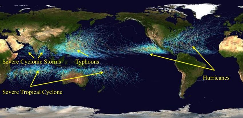
Figure 2. Atlantic Ocean Basin Hurricane Name List
                                                  Source

                                       Tropical Cyclone Tracks

Globally, there are approximately 80 tropical cyclones each year and about 60% of these reach
hurricane strength. Figure 3 shows the typical tropical cyclone track for those storms forming in
the Atlantic Basin, which includes the Caribbean Sea and Gulf of Mexico. Figure 4 shows all
the places on earth where tropical cyclones form and track. One of the most interesting features
on this map is that tropical cyclones never form between 5°N and 5°S. In fact, it is impossible
for a tropical cyclone to cross the equator! The reason they cannot track between these latitudes
or cross the equator is because tropical cyclones rely on the Coriolis force to circulate. The
Coriolis force is a force that exists because the earth spins on its axis. It is because of this force
that all large-scale low-pressure systems including hurricanes have winds that spin
counterclockwise in the Northern Hemisphere and clockwise in the Southern Hemisphere. To
learn more about the Coriolis force, watch this video! 1

                                          Coriolis Force (6:09)

                           Figure 3. Typical Hurricane Tracks in the Atlantic Ocean Basin

                                                                                                       3
    This work is licensed under a Creative Commons Attribution-ShareAlike 4.0 International License.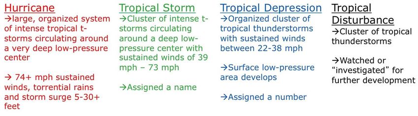
Figure 4. Lines show tropical cyclone tracks and the color shows storm intensity from 1985 – 2006.
                                                 Source

Tropical cyclones rarely form north of 30°N or south of 30°S because the waters there are too
cold. That is also the reason why the South Atlantic Ocean and the Pacific Ocean near South
America do not experience tropical cyclones – the water is too cold to support the development
of a tropical cyclone. One last thing to note in Figure 4, tropical cyclones have different names
depending on where they form. While we call them hurricanes in the U.S., in Japan they are
called typhoons, cyclones in India and Australia. These are just different names for the same
type of weather system.

                                Atlantic Ocean Hurricane Season

A typical hurricane season in the U.S. will include 10 named tropical cyclones, 6 hurricanes and
3 major hurricanes (Category 3+) and cost about $10 billion to clean up. On average, 47 deaths
will occur in the U.S. from hurricanes each year, which ranks them as the 4th deadliest weather
phenomenon. An important thing to remember is that only 11% of the world’s tropical
cyclones occur in the Atlantic Basin. As you can see in Figure 4, there are far more tropical
cyclones in the Pacific Ocean than in the Atlantic.

Hurricane season in the Atlantic Ocean, Caribbean Sea and Gulf of Mexico starts in June and
ends in November (see Figure 5). This season corresponds to the time of year when the sea
surface temperatures are warm enough to support hurricane development. A typical hurricane
season will reach a peak on September 10 and likely produce several tropical cyclones that will
make landfall. Figure 5 highlights those regions that are hit most often by hurricanes as well as
the locations in which hurricanes typically form each month of the hurricane season.

                                                                                                        4
    This work is licensed under a Creative Commons Attribution-ShareAlike 4.0 International License.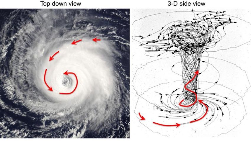
Figure 5. Atlantic Hurricane Season

                       Figure 6. Hurricane Landfall Frequency Along the U.S. Coastline
                                                   Source

Figure 7 on the next page shows the tracks of all the named tropical cyclones of the 2005 season
in the Atlantic Ocean. 2005 ranks as the most active hurricane season on record with 28 named
storms (on average, 10 named storms). During this season, the U.S. dealt with many land-
falling hurricanes, the worst of which was Katrina. To watch a satellite animation of Katrina,
check out this link!

                                Hurricane Katrina (Satellite) (1:38)

                                                                                                       5
    This work is licensed under a Creative Commons Attribution-ShareAlike 4.0 International License.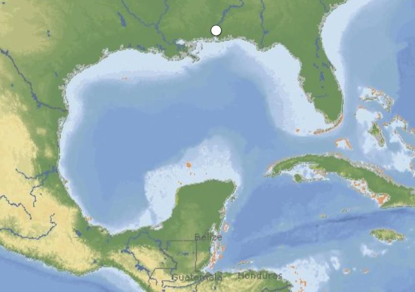
Figure 7. Tracks of the Tropical Cyclones from 2005 Hurricane Season
                                                  Source

                                         Hurricane Structure

In this section, we will define the major structural features of the hurricane. On average, a
hurricane is approximately 500 miles wide with a clearly defined eye in the center that may
have a diameter of 10 - 50 miles (see Figure 8). Most hurricanes last for 2 - 7 days, although
some have been known to last for 2 or more weeks! When viewed from space or on Doppler
radar, most well developed hurricanes have three distinct features – an eye, eyewall, and spiral
rainbands. Figure 8 shows each of these three features on satellite and radar. Starting from the
outside, the spiral rainbands are bands of intense rainfall that circulate around the center of the
hurricane. These rainbands can produce rainfall rates that exceed 2 inches an hour at times and
are responsible for much of the flooding associated with hurricanes. The most intense part of
the hurricane is the eyewall. Here are the hurricane’s most intense storms, fastest winds, and
heaviest rains. Just inside the eyewall is the hurricane eye. The eye is typically calm and clear
and it is in this part of the storm where we measure the lowest air pressure. Surrounding the eye
are thunderstorms that can be 12 miles tall that orbit around the eye at speeds approaching 200
mph! Figure 10 is a picture from within Hurricane Katrina’s eye. 2, 3

                                      Figure 8. Hurricane Structure

                                                                                                         6
      This work is licensed under a Creative Commons Attribution-ShareAlike 4.0 International License.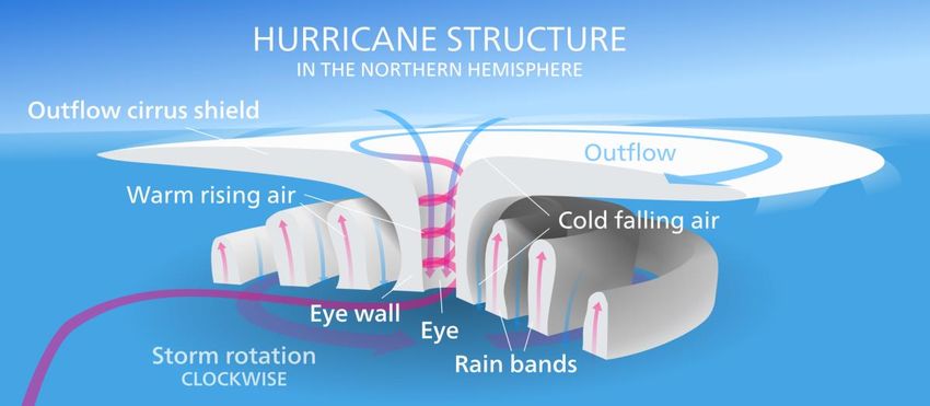
Figure 9. Hurricane Structure
                                                    Source

                                                      Figure 10. Hurricane Katrina’s Eye and Eyewall
                                                                           Source

                                          Destructive Forces

There are three main destructive forces of strong hurricanes that can kill people and destroy
property. First is storm surge, which is defined as a build up of ocean water and intense waves.
Many think that storm surge is like a tsunami, but in reality, they are quite different. Tsunamis
occur because of earthquakes that cause one large breaking wave that rushes onshore and
sweeps away everything at once. Storm surge is much different in that instead of one massive
wave, hurricane storm surge is created by many smaller waves that build on top of one another
with time. As the hurricane approaches, the wind-blown water can pile up 30 feet along the
coastal areas! To see what storm surge looks like, check out these two links and see Figure 11.

                             Hurricane Katrina Storm Surge (13:38)

                                        NHC Surge Simulation

                                                                                                         7
      This work is licensed under a Creative Commons Attribution-ShareAlike 4.0 International License.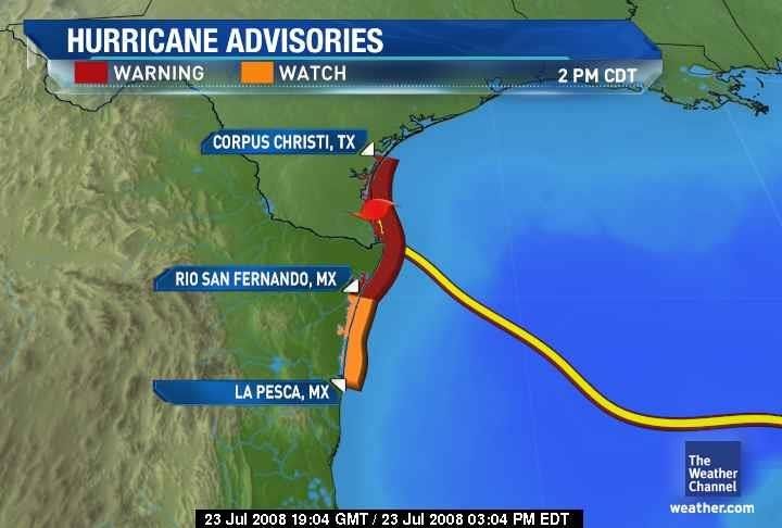
Figure 10. Hurricane Katrina’s Eye and Eyewall
                                                 Source

The second major destructive force are the hurricane force winds powered by the intense low-
pressure found in the center of the storm. They can last for several hours and relentlessly batter
a coastal city. Figure 12 shows how the winds circulate around a hurricane. In the Northern
Hemisphere, the winds circulate counterclockwise (clockwise in the Southern Hemisphere)
around tropical cyclones.

                                          Figure 12. Hurricane Winds
                                                     Source

 In general, the fastest wind speeds are found in the eyewall on the right side of tropical
 cyclones. The cyclone’s motion (forward speed) contributes to the counterclockwise wind
 speed. When the winds are in the same direction as the storm motion, the storm wind speed is
 added to the forward speed. When the winds are moving in the opposite direction, the forward
 speed is subtracted from the storm wind speed 5. This can increase the destruction in areas that
 are on the right side of the storm, during landfall especially. To see the destruction caused by
 these intense winds, check out the videos below!

                                          Hurricane Winds (2:09)

                                      Hurricane Destruction (0:39)

                                          Hurricane Wilma (3:38)
                                                                                                       8
    This work is licensed under a Creative Commons Attribution-ShareAlike 4.0 International License.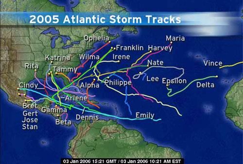
The third and by far most deadly aspect of a hurricane is inland flooding. Figure 13 reveals
how a hurricane’s destructive forces, particularly freshwater flooding, kill people. Hurricanes
can easily drop 10 to 20 inches of rain in a couple of days, which for some locations can be as
much as half a year’s worth of precipitation! Furthermore, the situation worsens if a hurricane
slows down and remains over one area for several days. Hurricane Mitch (1998) did just that
and stalled over the mountains of Central America. Some locations saw 50 inches of rain in two
days, which caused extreme flooding that killed 18,000 people! To see how bad floodwaters be,
check out these pictures!

                                             Flood Damage

                         Figure 13. Leading Causes of Tropical Cyclone Deaths in the U.S.

                                                                                                         9
      This work is licensed under a Creative Commons Attribution-ShareAlike 4.0 International License.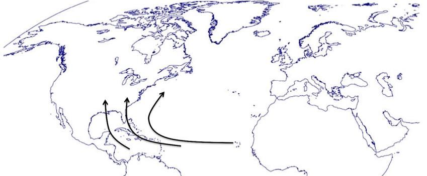
Hurricane Safety

If hurricane conditions are expected within 48 hours for a location, the National Hurricane
Center (NHC) will issue a hurricane watch. If hurricane conditions are expected within 36 hours
for a location, the NHC will issue a hurricane warning. Figure 14 is a map of a typical hurricane
watch/warning. If a hurricane warning has been issued for your location, evacuate immediately
if the evacuation order is given. Many who have stayed behind to “ride out” the hurricane have
lost their lives in addition to their property. For example, when Hurricane Ike (2008) was
headed toward Galveston, TX, many decided to stay in their homes rather than evacuate. For
those that stayed in their beach houses seen in Figure 15 many died as the storm surge wiped all
the houses off the shore except one. To learn more about preparing for weather hazards such as
hurricanes, visit this link from the NHC.

                                      Hurricane Preparedness

                                   Figure 14. Hurricane Advisory Map
                                                  Source

                    Figure 15. Beachfront Property Destroyed during Hurricane Ike (2008)
                                                    Source
                                                                                                           10
        This work is licensed under a Creative Commons Attribution-ShareAlike 4.0 International License.
Pre-Class Activity 4
Instructions: Before teaching about hurricanes, have the students answer the questions
below, followed by the scenario question for in-class discussion between you and your
students.
1. How many categories of hurricanes are there?
a. 1
b. 2
c. 3
d. 4
e. 5
f. 10
2. Which of the following is not another name for a hurricane?
a. Typhoon
b. Tsunami
c. Tropical Cyclone
d. Cyclone
3. What is the most destructive force associated with hurricanes?
a. Winds
b. Waves
c. Storm surge
d. Thunderstorms
e. Flooding
f. Tornados
4. What is the most deadly force associated with hurricanes?
a. Winds
b. Waves
c. Storm surge
d. Thunderstorms
e. Flooding
f. Tornados
5. Hurricane intensity is categorized by
a. Rainfall rate
b. Storm surge
c. Sustained wind speed
d. Wind gusts
e. Pressure
Discussion Question: You are living in Orlando, FL and a Hurricane Watch has been
issued for your town, but your friend that lives in Miami, FL calls you saying that a
Hurricane Warning has been issued for his/her area and wants to know the difference.
Using your best judgment, what would you tell him/her?
11
This work is licensed under a Creative Commons Attribution-ShareAlike 4.0 International License.In-Class Activity
Weather Situation: Hurricane
In this project, your group will forecast and prepare for a landfalling hurricane in the U.S.
Each group member will choose one of the following roles and complete the tasks written
at the end of each section.
1. Meteorologist
2. Homeowner in Galveston, TX
3. Mayor of Galveston, TX
4. General Manager of “The Home Depot” in Galveston, TX
Real World Application: Meteorologist 4
Task #1 Below is a map of the Gulf of Mexico and Caribbean Sea. The white circle
indicates the location of Mobile Bay, AL – a city that is especially vulnerable to
hurricanes. Your task is to draw an arrow that represents a typical track a hurricane would
take if it started in Jamaica and tracked between the Yucatan Peninsula and Cuba and
eventually hit Mobile Bay, AL. In the blank space below the map, draw your best
representation of a hurricane as viewed from a Doppler radar. Be sure to draw the spiral
rainbands, eyewall and eye.
12
This work is licensed under a Creative Commons Attribution-ShareAlike 4.0 International License.Task #2 As a meteorologist, it is important that you learn to properly convey weather
information to the general public. Your task is to create a 5-minute weather broadcast,
like you might see on the Weather Channel, about hurricanes. Remember that your
classmates will not know much about what you have just learned so be sure to address the
following topics in your broadcast:
1. Convey statistics about hurricanes in the U.S. (fatalities, frequency, etc.)
2. Discuss the Atlantic Hurricane Season and the Hurricane Name list
3. Show the Saffir-Simpson Scale
4. Explain the stages of development of a tropical cyclone
5. Discuss hurricane structure and each of the three main destructive forces
6. Talk about hurricane watches, warnings and safety
Build this weather broadcast using presentation software (like PowerPoint) and be sure to
include pictures and videos to supplement what you discuss. Your teacher has access to
several videos and pictures of hurricanes, so make sure to use your teacher as a resource
as well as the Internet. Be sure to be both informative and entertaining!
13
This work is licensed under a Creative Commons Attribution-ShareAlike 4.0 International License.Real World Application: Homeowner
It is September 2008 and you and your family have just moved to Galveston, TX. Since
you are from Illinois, you have no experience with hurricanes. On September 10, the
National Weather Service issued a Hurricane Warning as Hurricane Ike is expected to
directly hit Galveston in 2 days as a Category 4 hurricane. The Texas governor has just
issued a mandatory evacuation for Galveston! You have a spouse, three children and a
dog.
1. How do you use the next 24-48 hours to prepare for this evacuation and protect
your home from damage?
2. What supplies will you need?
3. Where will you find information about Galveston’s evacuation plan and route?
4. What will you bring with you when you evacuate?
5. Where will you stay during your evacuation?
The next day, you begin packing and preparing for your evacuation when your neighbor
comes over for a friendly chat. She mentions that she and her husband have decided not
to leave because there is a major football game on TV in two days and she says, “those
silly weathermen are never right anyways…”
1. Why do you think some people choose not to evacuate?
2. How would you respond to your neighbor?
TASK Set up a mock interview where one student assumes the role of the homeowner
(described above) and the other a TV reporter. In this interview, ask the questions above
about how to prepare to evacuate. Then, have your group put on a skit where two students
pretend to be the neighbors who don’t want to evacuate and the other two students
pretend to be the family that has chosen to evacuate. In the skit, the neighbors are
supposed to play the “devil’s advocate” and give all their reasons why they are staying.
The other two students have to try to convince them to evacuate!
14
This work is licensed under a Creative Commons Attribution-ShareAlike 4.0 International License.Real World Application: Mayor of Galveston, TX
You are the newly elected mayor of Galveston, TX and your job involves keeping your
citizens and community safe during hurricane season. Hurricanes frequently hit the Texas
coastline and to best prepare for the hurricane season you hold a meeting with other city
officials to answer the following questions.
1. Before a hurricane hits, what actions should we take to get prepared? (Think
about setting up shelters and getting fresh water, food, and other supplies to your
citizens)
The mayor must always be prepared to lead citizens to safety if/when the hurricane hits.
2. What type of planning can you do during the hurricane off-season to ensure that
you will be prepared to keep your citizens safe when hurricane season arrives?
3. Create a city evacuation plan brochure to share with the rest of the class. Consider
important components such as escape routes, carpool systems for citizens who do
not have cars, and ways to keep your citizens informed as the evacuation is taking
place.
In September 2008, Hurricane Ike destroyed much of Galveston.
4. What actions would you take as mayor to restore your city back to what it was
before the hurricane?
5. How would you assist your citizens in the recovery effort (money, resources,
equipment, etc.)?
6. How will you disperse information about the clean up effort?
7. How will keep your city safe from looting?
8. How will you deal with the additional need for emergency personnel?
Task Stage a mock interview where you play the role of the mayor. Have the interviewer
ask the questions written above and either perform the interview in front of the class or
record it so your classmates can see the your responses.
15
This work is licensed under a Creative Commons Attribution-ShareAlike 4.0 International License.Real World Application: General Manager of “The Home Depot” in Galveston, TX
You are the General Manager of “The Home Depot” in Galveston, TX and you just
received word that Hurricane Ike is expected to make landfall in Galveston in 3 days.
Your job is to prepare your store for this hurricane and make some crucial decisions, as
you will see in the questions below.
1. In preparation for this hurricane, how would you prepare your store’s inventory to
be in the best position to meet the demand of your customers?
2. What items should you overstock knowing they will be purchased because of this
hurricane?
As a manager, you have to make the decision to keep the store open during the hurricane
or close it down.
3. What are some of the benefits and drawbacks of keeping the store open? What
about closing it down?
4. If you decide to close the store, when should you make the final decision?
5. What will you do to prepare the storm for the hurricane?
6. How will you protect your inventory from being destroyed?
7. If you decide to keep the store open, how will you handle your employees that
don’t want to come to work because of the storm?
8. How will you keep those employees, that do make it to work, safe in the event
that the hurricane causes damage to the building?
9. If your store is partially destroyed by Hurricane Ike, how will your prepare for
reopening? How will you prevent looting?
10. How will you replace lost merchandise? (Remember that hurricanes cause
widespread destruction and many nearby stores will be damaged, too)
11. Do you take advantage of the opportunity to make extra profit on items citizens
will need to rebuild, like lumber, generators, and other building construction
materials, or do you reduce prices to help the community rebuild and hope that
you sell large enough quantities that the company will make a profit?
Task Write a short report that you would give to your regional manager with your
responses to these questions. Make an argument for why you would chose to take a
certain course of action and present your answers to these questions to the class. Be sure
to solicit comments and questions from your classmates as you present.
16
This work is licensed under a Creative Commons Attribution-ShareAlike 4.0 International License.Take Home Assignment
Part 1. Hurricane Patricia (2015) 2, 6
Hurricane Patricia formed off the western coast of Mexico from a low-pressure system on
October 20, 2015. Patricia strengthened from a tropical storm to a Category 5 hurricane
in 24 hours! The storm peaked in strength on the 23rd with maximum sustained winds of
200 mph and a central minimum pressure of 879 mb, as measured by NOAA's Hurricane
Hunters. Check out the video below to see the extreme turbulence experienced by the
Hurricane Hunters to get these measurements! Patricia was the most intense tropical
cyclone recorded in terms of barometric pressure in the Western Hemisphere.
Hurricane Hunters - Patricia 2015
Instructions: The table below provides Hurricane Patricia’s minimum central pressure
and maximum sustained wind speeds (data obtained from the National Hurricane Center).
Using this information, determine the strength of the tropical cyclone during its lifecycle.
Fill in the last column in Table 1 with Tropical Depression (TD), Tropical Storm (TS), or
Hurricane (H). If it is hurricane strength, be sure to include the category (see Table 2 for
example).
Table 1. Before Landfall
Date/Time Minimum Pressure Sustained Wind Strength
(mb) Speed (mph)
Oct. 20 at 10 a.m. 1006 mb 35 mph
Oct. 20 at 10 p.m. 1004 mb 40 mph
Oct. 22 at 1 a.m. 987 mb 75 mph
Oct. 22 at 10 a.m. 973 mb 100 mph
Oct. 22 at 1 p.m. 958 mb 130 mph
Oct. 22 at 10 p.m. 924 mb 160 mph
Questions
1. Briefly explain how you determined the strength of Patricia from October 20 – 22.
2. Patricia was slow to strengthen over the open waters of the Pacific, but favorable
environmental conditions led to a rapid intensification on October 22. List the
environmental conditions necessary for hurricane development.
17
This work is licensed under a Creative Commons Attribution-ShareAlike 4.0 International License.Patricia made landfall near Cuixmala, Mexico late on October 23. At landfall Patricia
had weakened with winds of 165 mph, still a Category 5 storm. Patricia's damage was
remarkably limited to no fatalities. The largest impact was agriculture losses. As Patricia
moved inland it quickly weakened to a remnant low on the 24th after interacting with high
terrain in western Mexico. Over the next few days the remnant low moved into the
southern U.S. where significant flooding was observed across Texas and the Gulf Coast.
Table 2. During/After Landfall
Date/Time Minimum Pressure Sustained Wind Strength
(mb) Speed (mph)
Oct. 23 at 1 p.m. 879 mb 200 mph H Cat 5
Oct. 23 at 10 p.m. 946 mb 130 mph H Cat 4
Oct. 24 at 1 a.m. 970 mb 100 mph H Cat 2
Oct. 24 at 4 a.m. 986 mb 75 mph H Cat 1
Oct. 24 at 7 a.m. 998 mb 50 mph TS
Oct. 24 at 10 p.m. 1002 mb 35 mph TD
Questions
3. Estimate the date and time of Patricia’s landfall (Use information from Table 2
and underlined sentence above). How did you come to this conclusion?
4. After landfall, Patricia’s pressure increased and wind speed rapidly decreased.
What do you think caused Patricia to weaken?
18
This work is licensed under a Creative Commons Attribution-ShareAlike 4.0 International License.Part 2. Wind Speed Calculation 5, 6
Instructions: Information about the rotational wind speeds and forward movement of
two hurricanes is provided in the sketches below. Four quadrants in each storm are
defined relative to the direction the storm is moving. Use the information to evaluate the
winds in the eyewall in the four quadrants of the storm (Right, Left, Front, and Back).
Wind speeds for Hurricane Abby have been completed for you as an example.
1. Draw the counterclockwise winds you would expect to see circulating around a
low-pressure system for A and B.
2. Using the given rotational wind speeds, calculate the actual wind speed in each
quadrant of the hurricane. Remember the rotational winds will ADD to the
forward movement of the hurricane on one side where the winds are in the same
direction as the storm motion and will be SUBTRACTED from the other.
3. Using the maximum wind speed for each hurricane, determine the Saffir-Simpson
rating.
Wind in Each Quadrant Saffir-Simpson
Hurricane Abby N: 105 S: 75 E: 90 W: 90 ________
Hurricane Benny NE: _____ SW: _____ NW: _____ SE: _____ ________
19
This work is licensed under a Creative Commons Attribution-ShareAlike 4.0 International License.Questions
1. Now that you have completed this exercise, on which side of a hurricane (Northern
Hemisphere) will the fastest winds be located and therefore, greatest storm surge, be
located relative to the storm motion: left or right?
2. If the same hurricanes were in the Southern Hemisphere, how would these calculations
be different? Briefly explain why.
Part 3. True/False (Circle One) 7
1. It is impossible for tropical cyclones to form within 5o of the equator. T F
2. The U.S. hurricane season peaks in September. T F
3. Hurricane Katrina is the most powerful hurricane on record. T F
4. Every hurricane makes landfall at least once. T F
5. Hurricanes can produce deadly tornados when they make landfall. T F
20
This work is licensed under a Creative Commons Attribution-ShareAlike 4.0 International License.Student Evaluation 8
Instructions: After completing the lesson on hurricanes, please have the students
answer the following questions below.
1. What is a tropical storm?
a. A tropical cyclone that has not reached hurricane strength yet
b. A tropical cyclone that has surpassed hurricane strength
c. A tropical cyclone that has already made landfall
d. An extremely weak tropical cyclone with winds 20 – 30 mph
2. What is the name of the scale that is used to categorize the strength of a
hurricane?
a. Enhanced Fujita Scale
b. Fujita Scale
c. Barometer Scale
d. Saffir-Simpson Scale
e. Cyclone Scale
3. Which of the following is necessary for hurricanes to form?
a. Warm ocean waters
b. Thunderstorms
c. A low-pressure system
d. High relative humidity in the Troposphere
e. All of the above
4. Hurricane season in the United States
a. begins in June
b. ends in September
c. is all year long
d. only occurs every 3 years
5. A typhoon
a. is the same as a tsunami.
b. is a weaker hurricane.
c. is a tropical cyclone that occurs in the western Pacific Ocean.
d. causes more damage than hurricanes.
6. Winds circulate ____________ around tropical cyclones in _________________.
a. clockwise, the Northern Hemisphere
b. counterclockwise, the Northern Hemisphere
c. clockwise, the Southern Hemisphere
d. counterclockwise, both hemispheres
21
This work is licensed under a Creative Commons Attribution-ShareAlike 4.0 International License.7. Where are the heaviest rain and fastest winds found in a hurricane?
a. Within the eye
b. Just outside of the rainbands
c. In the eyewall
d. Toward the top of the hurricane
8. Which of the following is not a destructive force associated with hurricanes?
a. Tornados
b. Flooding
c. Hurricane force winds
d. Extreme cold temperatures
e. Storm surge
9. Why do tropical cyclones rarely form north of 30oN or south of 30oS? Briefly
explain.
10. Calculate the Coriolis force at 15oN using the following equation. Make sure
your calculator is in degrees!
Coriolis = 2 x Ω x sin Θ
where Ω = 7.292 x 10⁻⁵/second and Θ is the latitude in degrees.
a. Coriolis = 0/sec
b. Coriolis = 0.0000948/sec
c. Coriolis = 0.0000377/sec
d. Coriolis = 474,189.89/sec
e. Coriolis = 948,379.79/sec
22
This work is licensed under a Creative Commons Attribution-ShareAlike 4.0 International License.Common Core State Standards (CCSS) Initiative
To learn more, visit http://www.corestandards.org
Next Generation Science Standards (NGSS)
To learn more, visit http://www.nextgenscience.org
The following standards are met in this learning module:
1. NGSS.MS-PS1-5
MS-PS1-5. Chemical Reactions (Connections to Nature of Science)
Laws are regularities or mathematical descriptions of natural phenomena.
Lecture: Tropical Cyclone Tracks: Coriolis Force
2. NGSS.MS-ESS2.5
MS-ESS2-5. Weather and Climate
Provide evidence for air pressure systems and resulting weather conditions.
Lecture: Hurricane Structure; Take Home Assignment: Part 1
3. NGSS.MS-PS2.2
MS-PS2.2. Forces and Interactions
Emphasis on balanced and unbalanced forces in a system and an object’s
motion (F = ma). This includes a specification of units.
Lecture: Hurricane Structure
4. CCSS.ELA-LITERACY.RST.6-8.4
Grade 6-8: Science and Technical Subjects
Determine the meaning of symbols, key terms, and other domain-specific
words and phrases as they are used in a specific science or technical context
relevant to grades 6-8 texts and topics.
Lectures: Bolded text; Pre-Class Activity; In-Class Activity: The Meteorologist
23
This work is licensed under a Creative Commons Attribution-ShareAlike 4.0 International License.5. CCSS.MATH.CONTENT.7.NS.A.1.C
Grade 7: The Number System
Understand subtraction of rational numbers as adding the additive inverse, and
apply this principle in real-world contexts.
Lectures: Destructive Forces; Take Home Assignment: Part 2
6. CCSS.ELA-LITERACY.RST.6-8.3
Grade 6-8: Science and Technical Subjects
Follow precisely a multistep procedure when carrying out experiments, taking
measurements, or performing technical tasks.
Take Home Activity: Parts 1 & 2
7. CCSS.ELA-LITERACY.RST.6-8.8
Grade 8: Science and Technical Subjects
Distinguish among facts, reasoned judgment based on research findings, and
speculation in a text.
Take Home Activity: Part 3
8. CCSS.MATH.CONTENT.8.EE.A.4
Grade 8: Expressions and Equations
Perform operations with numbers expressed in scientific notation, including
problems where both decimal and scientific notation are used. Interpret
scientific notation that has been generated by technology.
Student Evaluation
9. CCSS.ELA-LITERACY.RST.6-8.9
Grade 6-8: Science and Technical Subjects
Compare and contrast the information gained from experiments, simulations,
video or multimedia sources that gained from reading a text on the same
topic.
Video lectures
24
This work is licensed under a Creative Commons Attribution-ShareAlike 4.0 International License.10. CCSS.ELA-LITERACY.RST.6-8.7
Grade 6-8: Science and Technical Subjects
Integrate quantitative or technical information expressed in words in a text
with a version of that information expressed visually (e.g., in a flowchart,
diagram, model, graph, or table).
Video lectures
25
This work is licensed under a Creative Commons Attribution-ShareAlike 4.0 International License.You can also read