HURRICANE ISAIAS ADVISORY #15A - Magnolia Point Community Association
←
→
Page content transcription
If your browser does not render page correctly, please read the page content below
July 31, 2020 8:00 PM
HURRICANE ISAIAS
ADVISORY #15A
As of 8:00 pm Friday:
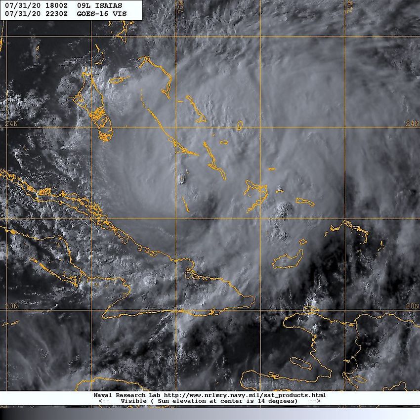
HURRICANE ISAIAS remains a CAT 1
storm and was located approximately
175 nm (200 mi) south-southeast of
Nassau and is moving northwest (310
deg) at 13 kts (15 mph) with max
sustained winds of 70G85 kts (80G95
mph).
Over the past 24 hrs, global forecast
models have tended to shift ISAIAS’ track
slightly back toward the west in response
to the persistence of the mid-Atlantic
high pressure ridge extending over FL
into the Gulf of Mexico. As the frontal
system currently over the upper mid-west
pushes southeast, the ridge will weaken
and allow ISAIAS to begin its turn to the
north-northeast. ISAIAS is forecast to track along the southeast-central coast of FL thru
Sunday evening before it begins to accelerate and make a turn to the north-northeast.
Slight intensification is expected over the next 24 hrs as ISAIAS continues to further organize
vertically and moves over slightly warmer sea surface temperatures. On the forecast track,
the center of ISAIAS will move near or over the Central Bahamas tonight, near or over the
Northwestern Bahamas Saturday and near the east coast of the Florida peninsula Saturday
afternoon through Sunday.
Based on the current forecast advisory, ISAIAS will pass within 70 nm (81 mi) to the east of
NAS Jacksonville early Monday morning with max winds of 60G75 kts (70G85 mph) as it
begins turning to the northeast. ISAIAS is currently forecast to make landfall near the SC-NC
border.
A Hurricane Warning and Storm Surge Watch have been issued for portions of the Florida
east coast. See below for tropical storm warnings or watches in effect for Florida coastal
regions.
HURRICANE ISAIAS ADVISORY #15A 1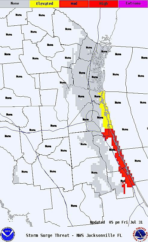
July 31, 2020 8:00 PM

Green Cove Springs Weather - Hi/Lo temps will remain in the low 90’s / mid 70’s with
isolated afternoon thunderstorms thru SAT. Based on ISAIAS current wind distribution and
closest point of approach, anticipate winds over the area will gradually increase to ENE at
15-20 kts with occasional gusts to 35 kts SUN afternoon thru Monday afternoon. Sustained
winds will be 5-10 kts higher at or near the coast. Expect higher gusts of in and around
thunderstorms. Scattered thunderstorms and moderate to occasionally heavy rains
associated with ISAIAS will move thru the area late SUN thru MON with total rainfall SAT thru
THU of 1.5” - 3”. Localized fl ooding is possible throughout the area with potential storm
surge of 1-2 ft east of I-295. Storm surge of 3-6+ ft is possible from St Augustine to points
south along the coast.

Based on NHC models, the probability of topical storm force winds over the local area
is 10%, increasing to 20% along the coast from SUN afternoon thru MON afternoon.

HURRICANE ISAIAS ADVISORY #15A                                                               2
July 31, 2020 8:00 PM

Forecast Positions and Maximum Winds
INIT    31/2100Z    22.6N     75.7W      65   KT   75   MPH
 12H    01/0600Z    23.9N     77.2W      70   KT   80   MPH
 24H    01/1800Z    25.4N     78.8W      75   KT   85   MPH
 36H    02/0600Z    26.8N     79.9W      70   KT   80   MPH
 48H    02/1800Z    28.3N     80.4W      65   KT   75   MPH
 60H    03/0600Z    30.0N     80.4W      60   KT   70   MPH
 72H    03/1800Z    32.5N     79.4W      60   KT   70   MPH
 96H    04/1800Z    39.0N     74.5W      55   KT   65   MPH
120H    05/1800Z    45.4N     65.9W      50   KT   60   MPH...POST-TROP/EXTRATROP

Present Wind Distribution
ESTIMATED MINIMUM CENTRAL PRESSURE 991 MB
MAX SUSTAINED WINDS 65 KT WITH GUSTS TO 80 KT.
64 KT....... 30NE 20SE    0SW 20NW.
50 KT....... 80NE 30SE    0SW 50NW.
34 KT.......150NE 70SE 30SW 130NW.
12 FT SEAS..300NE 150SE 90SW 300NW.
WINDS AND SEAS VARY GREATLY IN EACH QUADRANT.
RADII IN NAUTICAL MILES ARE THE LARGEST RADII EXPECTED ANYWHERE IN THAT QUADRANT.

Summary of Watches & Warnings:

A HURRICANE WARNING IS IN EFFECT FOR...
      * BOCA RATON TO THE VOLUSIA/BREVARD COUNTY LINE FLORIDA
      * NORTHWESTERN BAHAMAS
      * CENTRAL BAHAMAS

A HURRICANE WATCH IS IN EFFECT FOR...
      * HALLENDALE BEACH TO SOUTH OF BOCA RATON FLORIDA
      * VOLUSIA-BREVARD COUNTY LINE TO THE FLAGLER/VOLUSIA COUNTY LINE

A STORM SURGE WATCH IS IN EFFECT FOR...
      * JUPITER INLET TO PONTE VEDRE BEACH FLORIDA

A TROPICAL STORM WARNING IS IN EFFECT FOR...
       * NORTH OF OCEAN REEF TO SOUTH OF BOCA RATON FLORIDA
       * LAKE OKEECHOBEE

A TROPICAL STORM WATCH IS IN EFFECT FOR...
       * FLAGLER/VOLUSIA COUNTY LINE TO PONTE VEDRE BEACH FLORIDA

STORM SURGE: The combination of a dangerous storm surge and the tide will cause normally dry areas near
the coast to be fl ooded by rising waters moving inland from the shoreline. The water could reach the following
heights above ground somewhere in the indicated areas if the peak surge occurs at the time of high tide...

  Jupiter Inlet to Ponte Vedra Beach FL...2-4 ft
  North Miami Beach to Jupiter Inlet FL...1-3 ft

HURRICANE ISAIAS ADVISORY #15A                                                                                3
July 31, 2020 8:00 PM * CURRENT WATCHES AND WARNINGS ISSUED BY NWS JACKSONVILLE: ...TROPICAL STORM WATCH AND STORM SURGE WATCH FOR ST. JOHNS AND FLAGLER COUNTY COASTS... WIND: Prepare for hazardous winds having possible impacts across coastal St. Johns and Flagler counties. SURGE: Prepare for life-threatening surge having possible signifi cant impacts along the St. Johns and Flagler county coasts. Also, prepare for locally hazardous surge having possible limited impacts along the Nassau and Duval county Atlantic coasts, within the Intracoastal Waterway and St. Johns River basin. These bulletins are provided solely for the use of Magnolia Point residents and are not intended for use in place of official forecasts and warnings issued by the National Weather Service Forecast Office Jacksonville or the National Hurricane Center. Future bulletins will be provided as warranted. HURRICANE ISAIAS ADVISORY #15A 4
July 31, 2020 8:00 PM

                            DEFINITIONS & UNIT CONVERSION

                 ===========================================

A STORM SURGE WATCH MEANS THERE IS A POSSIBILITY OF LIFE-THREATENING INUNDATION FROM
RISING WATER MOVING INLAND FROM THE COASTLINE IN THE INDICATED LOCATIONS DURING THE NEXT
48 HOURS.

A STORM SURGE WARNING MEANS THERE IS A DANGER OF LIFE-THREATENING INUNDATION...FROM
RISING WATER MOVING INLAND FROM THE COASTLINE DURING THE NEXT 36 HOURS IN THE INDICATED
LOCATIONS.

A HURRICANE WARNING MEANS THAT HURRICANE CONDITIONS ARE EXPECTED SOMEWHERE WITHIN
THE WARNING AREA. PREPARATIONS TO PROTECT LIFE AND PROPERTY SHOULD BE RUSHED TO
COMPLETION.

A HURRICANE WATCH MEANS THAT HURRICANE CONDITIONS ARE POSSIBLE WITHIN THE WATCH AREA.
A WATCH IS TYPICALLY ISSUED 48 HOURS BEFORE THE ANTICIPATED FIRST OCCURRENCE OF TROPICAL-
STORM-FORCE
WINDS.

A TROPICAL STORM WARNING MEANS THAT TROPICAL STORM CONDITIONS ARE EXPECTED WITHIN THE
WARNING AREA WITHIN 36 HOURS.

A TROPICAL STORM WATCH MEANS THAT TROPICAL STORM CONDITIONS ARE POSSIBLE WITHIN THE
WATCH AREA...GENERALLY WITHIN 48 HOURS.

1 kt = 1.15 mph
1 nm = 1.15 mile                                 HURRICANE CATEGORIES

                                                             KTS        MPH

                                                CAT 1       64-82       74-95

                                                CAT 2       83-95       96-110

                                                CAT 3       96-112     111-130

                                                CAT 4      113-136     131-155

                                                CAT 5        >137       >155

HURRICANE ISAIAS ADVISORY #15A                                                              5
You can also read