New Zealand Aviation MET Symposium - POWERFUL WEATHER INTELLIGENCE - Civil Aviation Authority of New Zealand
←
→
Page content transcription
If your browser does not render page correctly, please read the page content below
New Zealand Aviation MET Symposium
POWERFUL WEATHER INTELLIGENCE
Airport Observing Systems

Kevin Alder
Manager, Meteorological Data Services
E kevin.alder@metservice.com
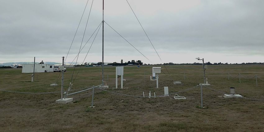
Airport observing systems
Airport observing systems

• New Zealand is one of the few countries in the world to
  operate a fully-automated Airport Observing System
  across its national network
• Automated reporting at 31 airports produce ICAO-
  compliant AUTO METAR reports every half-hour
• The network is supported from the MetService
  Engineering and Calibration facilities at Paraparaumu
Airport observing systems

• AUTO METAR reports are also supplemented by data
  from our lightning detection network to advise of TS
  nearby airports
• The network also has 23 webcams giving forecasters
  round-the-clock views of airfield conditions
• In addition, there are another 16 AWS at other airfields
  in support of charter operators and GA
Weather radar
Weather radar

• There are 9 weather radar in our national network
• Planning is under way to add a 10th radar in
  coastal Otago
• It is due to go ‘live’ in 2019
Aircraft-based observations
Aircraft-based observations
Aircraft-based observations

                              • Planned AMDAR
                                reporting area
Aviation Forecast Operations Paula Acethorp Manager, Aviation Weather Services E paula.acethorp@metservice.com
Resilience

• Phase 1A is completed – what can you expect now?
• Auckland forecast office staff – growing the numbers
• Generation of domestic aviation products being made
  ‘resilient’ over the next 12-18 months; delivery
  platforms next 12-24 months.

                                                         WRF in the cloud
Graphical forecast product developments • Done – new volcanic ash graphic, graphical SIGMET monitors
Prototypes - ARFOR & Sit Brief replacements
TAF QNH & 2000 ft wind replacement concept
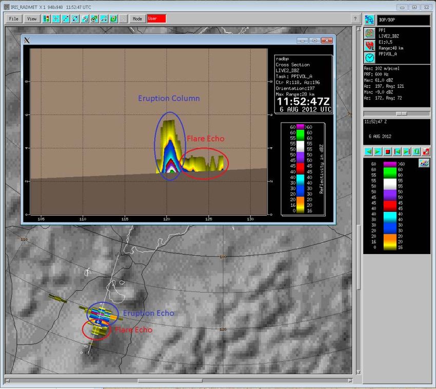
What else?VAAC Wellington activities • Radar alerts – a tool to detect New Zealand volcanic eruptions • HYSPLIT – ensemble forecasting, soon to be in the cloud • VAAC Darwin back-up arrangements
VAAC Wellington - future

VOLCAT plans
• VOLcanic cloud analysis toolkit
Concentration charts?
• Rolls-Royce position
  “Engines exposed to a cumulative volcanic ash dose of
  14.4 g s/m3 or lower, between actual ash concentrations
  of 0.2 to 4 mg/m3 should not lead to a significant
  reduction in engine related flight safety margins (e.g. 2
  hours at 2 mg/m3)” (All RB211 and Trent Engines)
Review of products

Trends – are they still required?

Harmonised phenomena-based warnings –
can we make NZZC/NZZO SIGMETs           TAFs – what’s still useful; what new locations
seamless?                               are required? What criteria should we use?
The future forecaster

• Video briefings via MetService TV

• Embedded/consulting meteorologists
Aviation Portal, API

Matthew Corey
Manager, Data, Analytics, Platforms
E matthew.corey@metservice.com
Application Programming Interface - API

• Weather data available for developers
• Secure, reliable, expanding
• Basic data, but client-driven
  development, ICAO compliant formats
• Contact us for beta-testing
New platform – aviation portal refresh

• New portal will preserve functionality
  but add capabilities
• Modular widgets = configurable
• Responsive – mobile-friendly
• Single login and user administration
• Looking for beta-testers!
MET CDM

Ray Thorpe
General Manager Sales New Zealand
E ray.thorpe@metservice.com
Future best practice centred around MET-CDM
Lightning circles
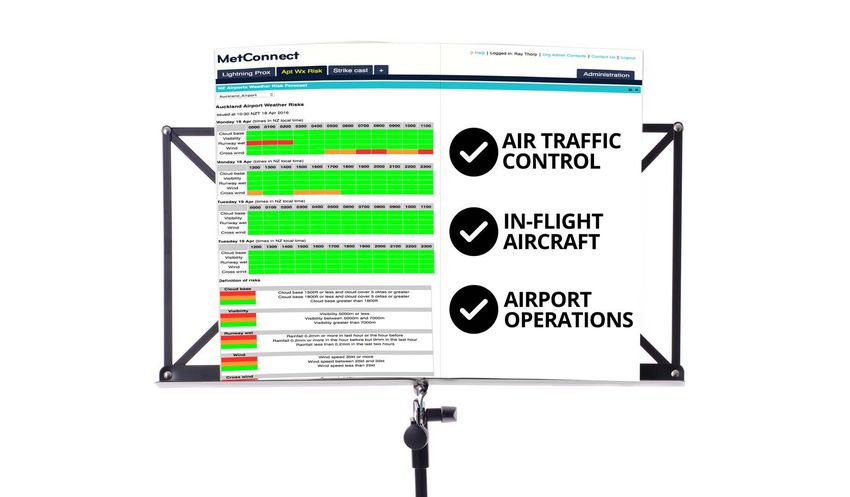
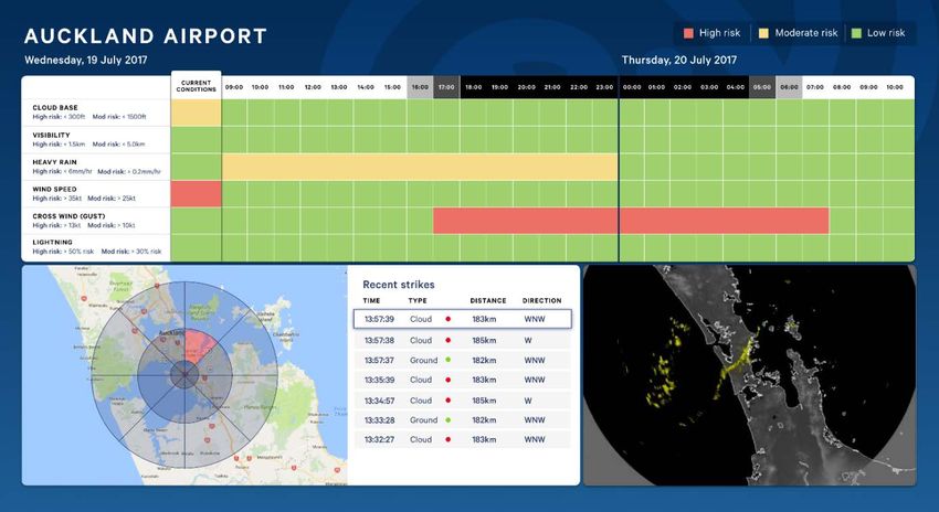
• Real-time visual proximity alerts
• User-configurable number and size of range rings
• There are eight segments per range ring
(north, northeast, east, southeast, south,
southwest, west, northwest)
• Place lightning circle over your asset or area
of interest (airport, hotel)
• All lightning detected by the LDN is displayed
on screen
• As these lightning strikes approach your asset
and events pass over the lightning circle, the lighting circle
segments will turn red
• Regional-to-local lightning awarenessLightning alerts • Email alerts - direct to your computer or mobile phone • SMS txt alerts – direct to your mobile phone • Alerts are geofences based on the boundaries of your asset or area of interest • Two levels of warning: • Alert • Warning • All clear messages are sent
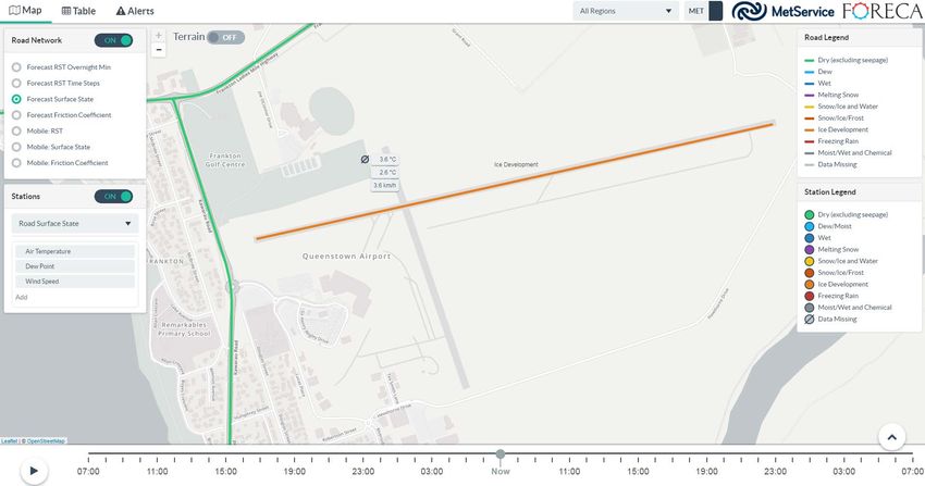
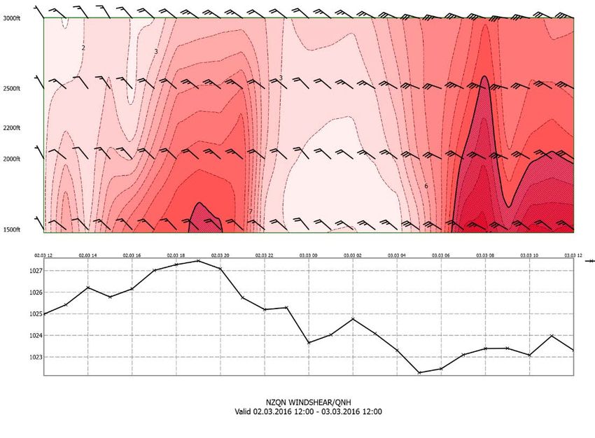
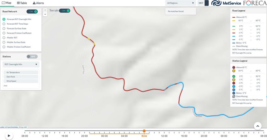
Forecast runway surface state
Forecast runway surface state
Forecast runway surface state
Forecast – example of 30m resolution
SPLDN – current and potential locations
Thank you

            AMDAR
You can also read