11 AM EDT Tuesday, October 9, 2018 Hurricane Michael, Tropical Storm Leslie, Tropical Storm Nadine - Hernando Connects
←
→
Page content transcription
If your browser does not render page correctly, please read the page content below
Tropical Update
                      11 AM EDT
               Tuesday, October 9, 2018
    Hurricane Michael, Tropical Storm Leslie, Tropical
                    Storm Nadine
This update is intended for government and emergency response officials, and is provided for
informational and situational awareness purposes only. Forecast conditions are subject to
change based on a variety of environmental factors. For additional information, or for any life
safety concerns with an active weather event please contact your County Emergency
Management or Public Safety Office, local National Weather Service forecast office or visit the
National Hurricane Center website at www.nhc.noaa.gov.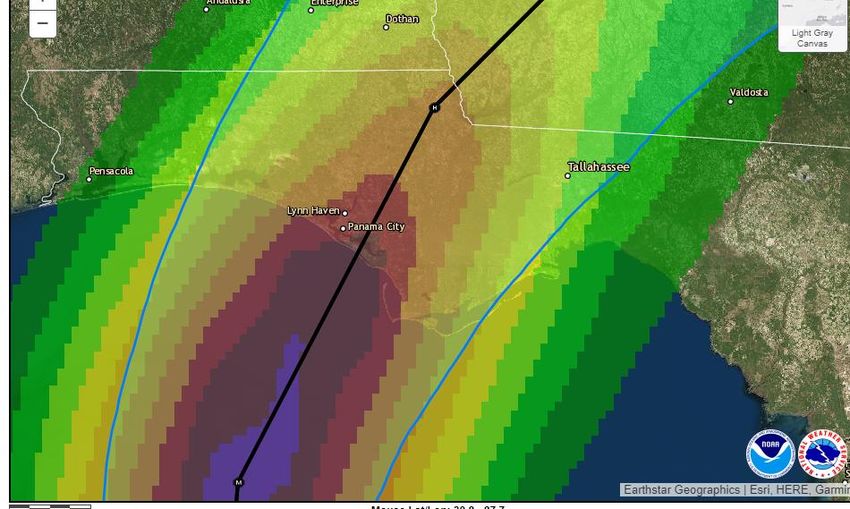
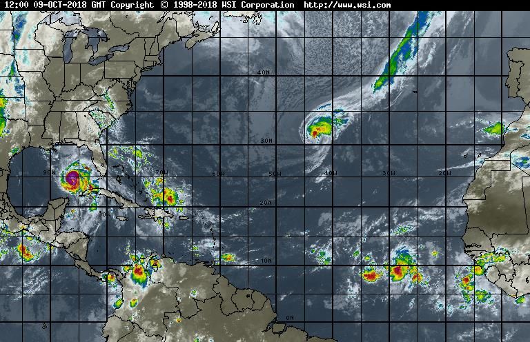
Atlantic Basin Satellite Image
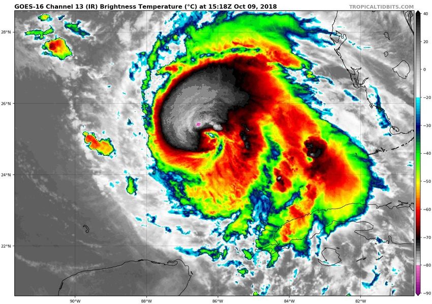
Hurricane Michael Satellite Image
 Thunderstorms are wrapping
      around the center of
  circulation, an indication of
    intensification. An eye is
  starting to become visible.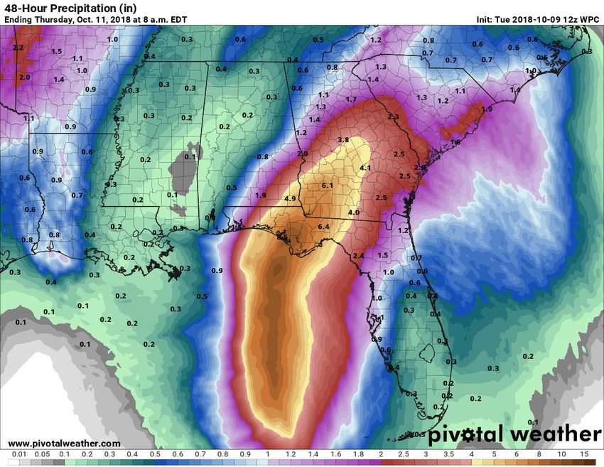
Leslie will move slowly southwestward over the next
few days, but it will accelerate northeast again later
this week. Leslie may strengthen to a hurricane when it
moves southwest over warmer waters.
150
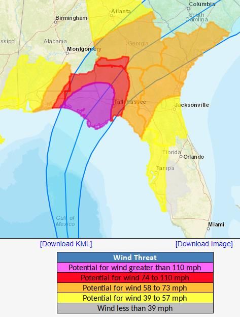
Michael is currently forecast to miles
strengthen to a Category 2
before landfall.
330
miles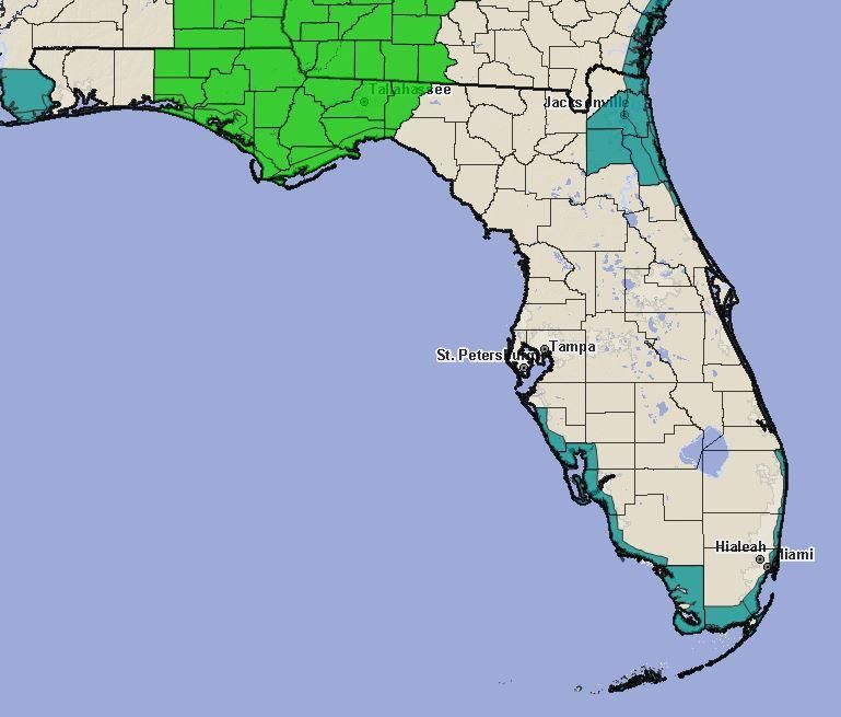
Tropical Storm Watch
Tropical Storm Warning
Hurricane Warning
NHC Cone + Chance of Hurricane
        Force Winds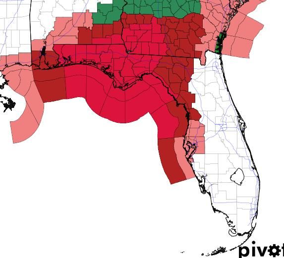
Hurrevac Timing of onset of TS winds – Wednesday (assumes a perfect
                     forecast) (all time eastern)

                             Hurricane force
                             winds
                             approximately
                             6hrs later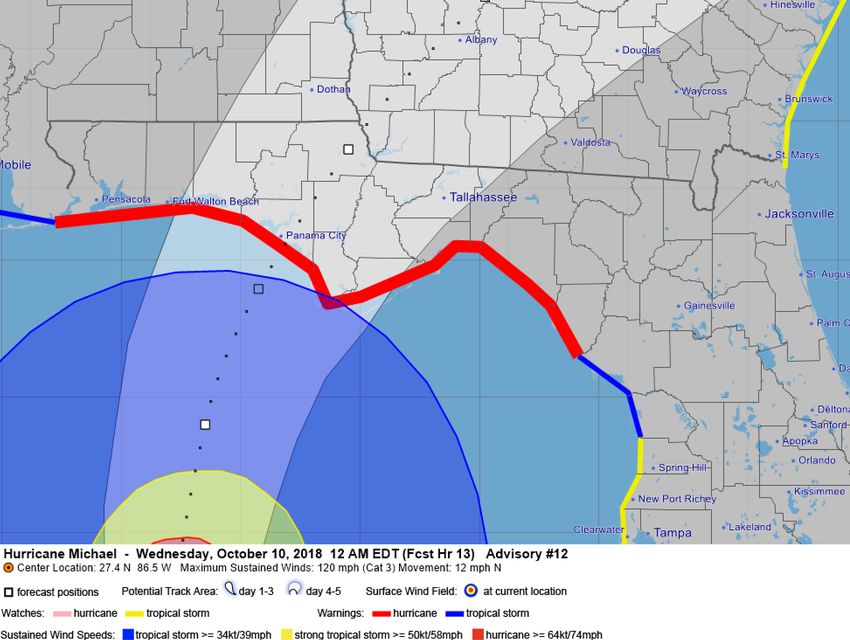
Hurrevac Timing of onset of TS winds – Wednesday (assumes a perfect
                     forecast) (all times eastern)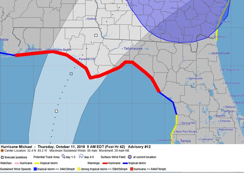
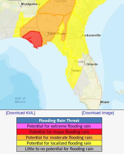
Forecast Cumulative Rain Totals – Next 48 Hours
Rain bands will begin impacting parts of the Panhandle, Big Bend, and West Coast today. Rain totals will
be maximized east of where Michael tracks. A Flash Flood Watch is in effect for portions of the Big Bend
and eastern Panhandle where 4-8” of rain is expected with isolated totals of 10-12” possible.
Flash Flood Watch in effect
        (light green)
The risk for isolated tornadoes will increase as outer bands move onshore, especially to the northeast of the center of Michael.
Forecast Wave Heights

Ocean swells will increase the rip current threat
along the Panhandle coast and West Coast. Wave
heights along the Panhandle and Big Bend may
peak at 15-25’ at the beach and much higher
offshore. Beach erosion likely.
Post-Storm High/Low Temperature
        Forecast - Thursday
Post-Storm High/Low Temperature
Forecast - FridayPost-Storm High/Low Temperature
Forecast - SaturdayNadine will move northwestward over the next few days. Weakening and dissipation is forecast this weekend.
Tropical Storm Leslie:
                                        Summary
• At 11 AM EDT Tuesday, Tropical Storm Leslie was located about in the central Atlantic Ocean with
    maximum sustained winds near 65 mph and moving south-southeast at 13mph.
• Leslie could become a hurricane later this week before turning toward the east-northeast toward
    Portugal.
Tropical Storm Nadine:
• Tropical Depression #15 was upgraded to Tropical Storm Nadine in the eastern Atlantic Ocean with
    maximum sustained winds near 40 mph
• Some strengthening is forecast over the next couple days while moving northwest, but is forecast to
    dissipate this weekend.
Hurricane Michael:
• As of 11 AM EDT Tuesday, Hurricane Michael was located about 335 miles south of Apalachicola, FL, and
    moving north at 12mph.
• Maximum sustained winds have increased to 110 mph, a Category 2 on the Saffir-Simpson Hurricane
    Wind Scale.
• Additional strengthening is expected, and Michael is expected to become a major hurricane later today.
• Landfall is expected in the Panhandle or Big Bend sometime on Wednesday.
• Tropical storm force winds extend up to 185 miles from the center and hurricane force winds extending
    up to 35 miles from the center.
Florida Outlook:
• The eastern Florida Panhandle and western Big Bend remain within the cone of error for landfall potential.
• An increase in water levels from Michael are already present and wave heights will continue to increase through
Thursday morning.
• Tropical storm conditions may arrive in the Panhandle as soon as tonight but no later than late Wednesday morning. If
the track shifts eastward or expands in size, the Florida West Coast could experience tropical storm force winds tonight
or early tomorrow morning. Hurricane conditions should arrive in the Panhandle Wednesday afternoon or evening.
• Tropical Storm Wind Watches are in effect for 5 counties along the Florida West Coast, with a Tropical Storm Warning
in effect for 10 counties in the eastern Big Bend, Suwannee Valley and Nature Coast.
• Hurricane Warnings are in effect for 18 Panhandle and Big Bend counties, including coastal portions of Taylor and
Dixie.
• Storm surge will be one of the greatest impacts from this storm and may affect a large portion of the Florida Gulf
Coast. Storm Surge Warnings have been issued between the Walton/Okaloosa border eastward to the Pasco/Pinellas
County line for possible surge inundation of 6-9’ for the eastern Panhandle coast and Nature Coast, and 8-12’ for
Apalachee Bay. Storm Surge Watches remain in effect for the western Panhandle and Tampa Bay region for possible
surge values of 2-4’.
• Widespread rainfall totals of 4-8” with locally higher amounts of 8-10+” can be expected across the Panhandle and Big
Bend, with most of it occurring on Wednesday.
• Isolated tornadoes will be possible Wednesday across North Florida and even northern portions of Central Florida.
Tornado Watches will likely be issued tomorrow.
• Ocean swells from Tropical Storm Leslie and breezy onshore winds from high pressure to the north of Florida will
continue producing high risk of rip currents along all Atlantic beaches.
• Tropical Depression Nadine is not expected to affect Florida.
Another briefing packet will be issued later this afternoon. For the latest information on the tropics, please visit the
National Hurricane Center website at www.hurricanes.gov.Tropical Update
Created by:
Amy Godsey, Chief State Meteorologist
Amy.Godsey@em.myflorida.com
State Meteorological Support Unit
Florida Division of Emergency
Management
Users wishing to subscribe (approval pending) to this distribution list, register
at https://public.govdelivery.com/accounts/FLDEM/subscriber/new?topic_id=SERT_Met
_Tropics.
Other reports available for subscription are available at
https://public.govdelivery.com/accounts/FLDEM/subscriber/new?preferences=trueYou can also read