OFFICIAL Red tails of the Glenelg Plain Cultural Burning Project: GHCMA
←
→
Page content transcription
If your browser does not render page correctly, please read the page content below
OFFICIAL

Red tails of the Glenelg Plain Cultural Burning Project:
Vegetation monitoring results from year 1

Ben Zeeman and Matt King (Glenelg Hopkins CMA)

Introduction
The endangered South-eastern Red-tailed Black Cockatoo occurs as a single population in south-west
Victoria and south-east South Australia (Burnard and Pritchard 2013) and has been undergoing long-
term and sustained decline since at least 1999 (Hill & Bennett 2020). The species has a highly specialised
feeding habit, limited to the fruit of Brown and Desert Stringybark (Eucalyptus baxteri and E. arenacea)
in the Glenelg Hopkins region. This food resource can be compromised through the practice of hazard
reduction burning in instances where fire scorches the tree canopy, as this can largely inhibit food
production for up to a decade (Koch 2005). The Glenelg Hopkins cultural burning project is examining
the use of traditional Aboriginal burning techniques as an alternative to contemporary hazard reduction
burning methods. Traditional burning techniques are expected to be low intensity and avoid canopy
scorch. However, how these burns may effectively reduce fire risk in the future is not currently well
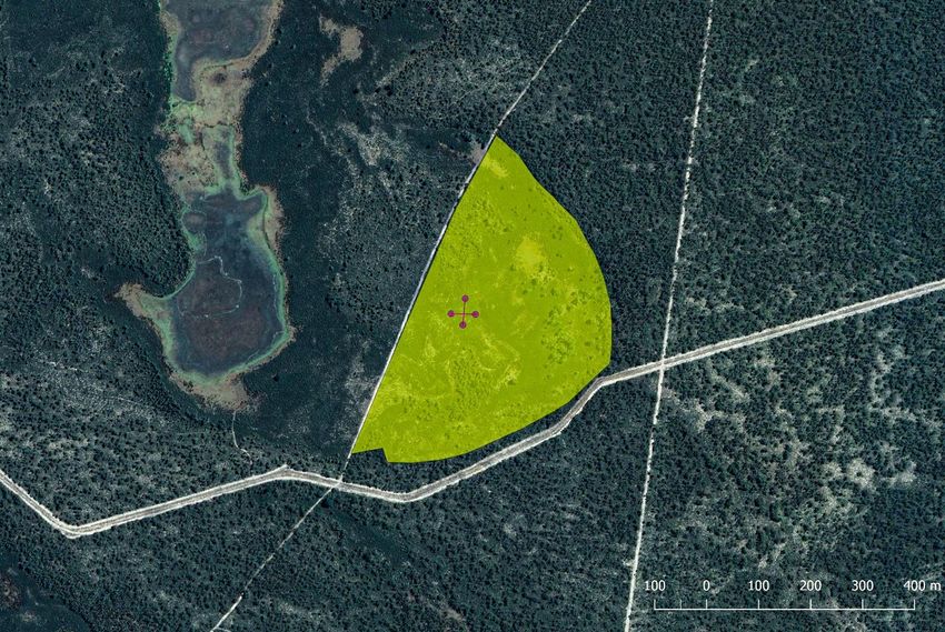
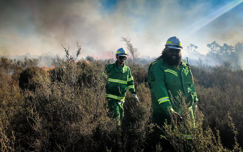
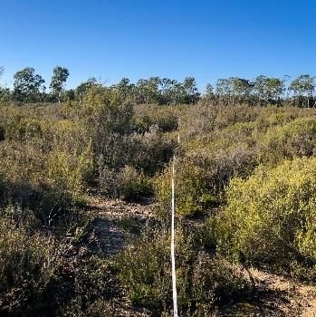
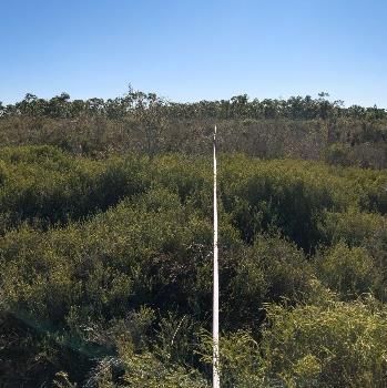
OFFICIAL

understood. Over a four-year period, the Glenelg Hopkins CMA will work for Traditional Owners to
monitor vegetation responses to these traditional burning techniques. Outlined below are the initial
results from the first cultural burn undertaken through the project in South-eastern Red-tailed Black
Cockatoo habitat.

Methods
The projects first cultural burn occurred on the 17th of July 2020 at the Nangeela State Forest,
approximately 14 km west of Casterton in south-west Victoria (Fig. 1). A total of 16 ha were burnt. Air
temperature throughout the day varied from 6ᵒC to 14ᵒC, with north to north-westerly winds ranging
from 13 to 17 km/h. Relative humidity varied from 66% to 95%.

Fig. 1. Map of Nengeela State Forest Burn Site. Yellow shading represents burn area. Crossed red lines
indicate the location of vegetation monitoring transects. Photos taken at the ends of each vegetation
monitoring transect.
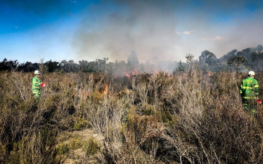
OFFICIAL

A vegetation monitoring plot was established and surveyed initially on the 10th of June 2020 prior to the
burn. The plot consisted of two 50 m transects, running perpendicular and intersecting at the mid-point
to form a cross (Fig. 1). Transects were marked with tomato stakes at the beginning and end points and
mapped using GPS. Fifty-meter measuring tapes were placed along each transect. A metal pin (5 mm in
diameter and 1 m in length) was then placed vertically to the ground at 50 cm intervals along the 50 m
measuring tape, with species touching the pin at the highest point recorded at each interval in addition
to vegetation height. Where no plant touched the pin, ground cover was recorded as either bare
ground, organic litter or cryptogamic crust (moss, lichen or cyanobacteria). The plot was then re-
surveyed on the 10th of October 2020, 3 months following the burn.

Changes in the frequency of all plant species and cover types following the burn were examined and
paired t-tests were used to analyse changes in vegetation height (a proxy measure of changes in
biomass following the burn).

Results and Discussion
Three months following the July cultural burn, the cover of dead vegetation was 77% higher (Fig. 2; t = -
4.42, df = 122, p = 0.001; Fig. 4). However, the total cover of dead vegetation still only reached 31% of
total cover following fire and bare ground only reached 2.5%, indicating a patchy and low intensity burn.
This was consistent with observations on the day of the burn, with flame height remaining relatively low
(Fig. 3).

The patchiness of the fire appears to have been driven by variation in the flammability of plant species.
For example, Hibbertia virgata appears to have been particularly flammable, with a 60% decline in cover
and a significant decline in alive vegetation height (t = 4.76, df = 296, p =
OFFICIAL

                                  Hibbertia virgata                                         25%
                                                                    10%
                                                                               16%                Pre-burn
                         Leptospermum continentale                    12.5%
                               Melaleuca brevifolia                           15%                 Post-burn
                                                                                    18.5%
                             Allocasuarina paludosa          6%
                                                             6%
                             Xanthorrhoea australis      4.5%
                                                            5%
                                 Banksia marginata       4.5%
                                                            5%
Frequency of occurance

                                Lepidosperma laeve      1.5%
                                                      0%
                                    Hakea rostrata     1%
                                                       1%
                                 Melaleuca gibbosa    0.5%
                                                      0.5%
                                    Banksia ornata    0.5%
                                                      0%
                          Rytidosperma geniculatum    0%
                                                      0.5%
                            Chamaescilla corymbosa    0%
                                                       1%
                                  Rytidosperma sp.    0%
                                                       1%

                                   Dead vegetation                              17.5%
                                                                                                  31%
                                 Cryptogamic crust          6.5%
                                                          5.5%
                                       Bare ground     1.5%
                                                          2.5%

Fig. 2 The frequency of occurrence for each species and cover type recorded along the vegetation
monitoring transects pre- and post-burn.

Fig. 3. Flame heights remained low during the burn and patterns of the burn appeared patchy.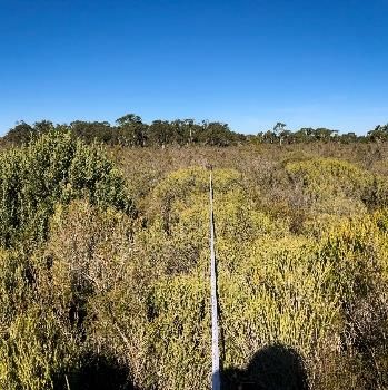
OFFICIAL

(a) Alive vegetation                       (b) Hibbertia virgata               (c) Leptospermum
                                                                                   continentale
    t = 4.76, df = 296, p =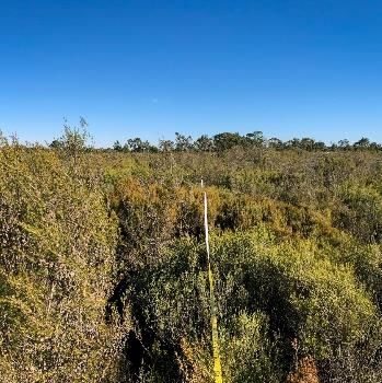
OFFICIAL

References
Burnard T, Pritchard R (2013) DRAFT: National recovery plan for the South-eastern Red-tailed Black
Cockatoo Calyptorhynchus banksia graptogyne. South-eastern Red-tailed Black Cockatoo recovery team.

Hill R, Bennett K (2020) Population monitoring of the South-eastern Red-tailed Black Cockatoo: flock
count report August 2020, report prepared for the South-eastern Red-tailed Black Cockatoo recovery
team.

Koch P (2005) Factors influencing food availability for the endangered south-eastern Red-tailed Black
Cockatoo Calyptorhynchus banksia graptogyne in remnant stringybark woodland, and implications for
management. PhD thesis, The University of Adelaide
You can also read