AMBER MEETS IRIS The importance of remote sensing from Sentinel missions for monitoring and managing our river systems - Eventi PoliMi
←
→
Page content transcription
If your browser does not render page correctly, please read the page content below
AMBER MEETS IRIS
The importance of remote sensing from Sentinel missions for
monitoring and managing our river systems
24th September 2018
Aula Castigliano, Politecnico di Milano
Ed. 5 - Arturo Canusso
Piazza Leonardo da Vinci, 32 - 20133 Milano
Info: barbara.belletti@polimi.it
Rivers rank among some of the most threatened ecosystems in the world and are the focus of costly restoration
and management programmes targeted to improve river conditions and to ensure the essential functions and
services that rivers provide to our society. The scope of this workshop is to discuss recent advances in river
management and monitoring strategies, by combining results from two projects lead by the Natural Research
Management (NRM) group of the Politecnico di Milano: AMBER and IRIS. AMBER (Adaptive Management of
Barriers in European Rivers) is a H2020 project which explores adaptive management to the operation of dams
and barriers in European rivers. The project aims to achieve a more efficient restoration of stream connectivity,
and to address impacts caused by river fragmentation adopting emerging technologies in remote sensing,
numerical models and other fields. The IRIS (Italian Research and development Initiative for Spaceborne river
monitoring) project aims at developing tools for monitoring medium-large river systems from remote sensing
combining drones, traditional field techniques and satellite data from the Sentinel missions of the Copernicus
program. IRIS is funded by the Italian Environmental Agency (ISPRA) under the umbrella of the ASI-ISPRA
initiative “Habitat Mapping”.
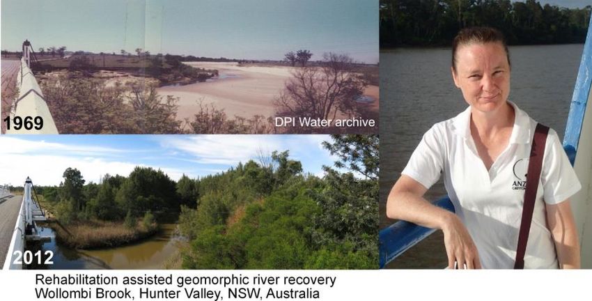
Kirstie Fryirs, Professor of fluvial geomorphology at the Macquarie University (Sydney, Australia), will open the
workshop, bringing us examples of the consolidated experiences she and her research group have developed
over the last decade in Australia and New Zealand in the field of fundamental and applied fluvial
geomorphology.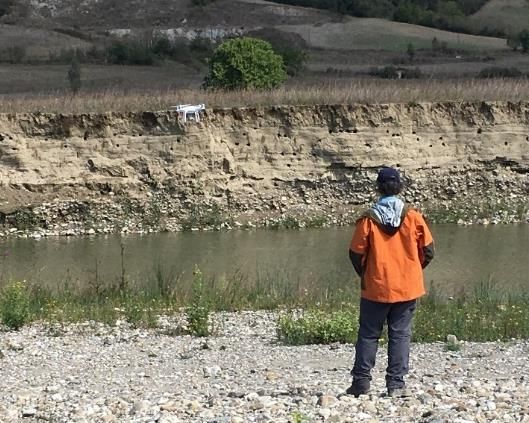
PROGRAMME
10:00-10:10             Introduction and welcome
                        C.M. Prati (Dipartimento di Elettronica Informazione e Bioingegneria, POLIMI)
10:10-10:50             KEYNOTE TALK - Do we still need a human? Geomorphic analysis and
                        interpretation of river systems in an age of emerging technology and big data
                        K. Fryirs (Macquarie University, Australia)
10:50-11:10             Managing river barriers and sediments at the European scale: the H2020 AMBER
                        project and beyond
                        B. Belletti, S. Bizzi (DEIB - Politecnico di Milano, Italy)
11:10-11:30             BREAK
11:30-11:50             Why IRIS? Opportunities and challenges by RS technology for the implementation of
                        the IDRAIM framework
                        M. Bussettini (ISPRA, Roma, Italy)
11:50-12:10             Italian Research and development Initiative for Spaceborne river monitoring (IRIS) in
                        the framework of the ASI-ISPRA project “Habitat Mapping”
                        S. Mariani (ISPRA, Roma; Italy)
12:10-12:30             Italian National plan for environmental operational services
                        A. Taramelli (IUSS Pavia; ISPRA, Roma, Italy)
12:30-12:50             Assess success of restoration measures by means of Remote sensing techniques
                        F. Comiti (Libera Università di Bolzano, Italy)
12:50-13:20             ROUND TABLE
14:45-17.30             The Fluvial System afternoon: contributions from young Italian river scientists
                        (program soon available)

                                              https://www.researchgate.net/project/Italian-Research-and-development-
          www.amber.international             Intiative-for-Spaceborne-river-monitoring-IRIS
       https://twitter.com/ambertools
  https://www.facebook.com/AMBERtools
KEYNOTE TALK
Do we still need a human? Geomorphic analysis and interpretation of river systems in an age of
emerging technology and big data.
Professor Kirstie Fryirs - Department of Environmental Sciences, Macquarie University, Sydney, Australia
Emerging technologies and big data open up opportunities for landscape and river analysis like never before.
With the emergence of new technologies that can generate big data, and the use of that data to make
environmental management decisions, it is timely to reflect on whether a human is still need to undertake such
analyses? The answer is yes!
We still need humans to:
1) have the conceptual grounding and training to ask questions of scientific and management significance,
2) select the right tool for the job,
3) collect the right data using the technology available (or decide to use traditional methods where needed),
4) interrogate and interpret the output,
5) verify the output in the field (make sure it’s real), and
6) make well-informed river management decisions that are place-based.
In this presentation I will use the case study of the River Styles Framework as a coherent, scaffolded
geomorphic approach to analysis of river types, condition and recovery potential, and discuss where
opportunities lie for emerging technology and tools to be ‘plugged in’ to the process. I will also discuss where
the technology is not yet good enough to replace the human! I will use the roll-out and application of the
Framework across NSW, Australia (2.7 x the area of Italy) to demonstrate how geomorphic analysis of river
systems is used in river management planning and prioritisation.

Biography
Kirstie's research focuses
on fluvial geomorphology, in
particular river evolution,
sediment      budgets    and
landscape (dis)connectivity,
and human disturbance to
rivers. She has developed
frameworks for assessing
the physical condition and
recovery potential of river
systems.      She    is   co-
developer of the River Styles
Framework and a portfolio of
professional     development
short courses. She works closely with federal and state government and industry on river management
planning, policy and decision-making, and the use of geomorphology in the process. She has also undertaken
research on heavy metal contamination at Casey and Wilkes stations in Antarctica. She is the author of over
100 scientific papers and has co-written or edited three books titled "Geomorphology and River Management",
"River Futures" and "Geomorphic Analysis of River Systems: An Approach to Reading the landscape". Kirstie
is the winner of the Gordon Warwick medal for excellence in research.

https://directory.science.mq.edu.au/users/kfryirs
https://researchers.mq.edu.au/en/persons/kirstie-fryirs
http://www.riverstyles.com
You can also read