Louisiana Hurricane History - David Roth National Weather Service Camp Springs, MD
←
→
Page content transcription
If your browser does not render page correctly, please read the page content below
Louisiana Hurricane History
             David Roth
       National Weather Service
         Camp Springs, MD
Table of Contents
Climatology of Tropical Cyclones in Louisiana                            3
List of Louisiana Hurricanes                                             8
Spanish Conquistadors and the Storm of 1527                              11
Hurricanes of the Eighteenth Century                                     11
Hurricanes of the Early Nineteenth Century                               14
Hurricanes of the Late Nineteenth Century                                17
   Deadliest Hurricane in Louisiana History - Chenier Caminanda (1893)   25
Hurricanes of the Early Twentieth Century                                28
Hurricanes of the Late Twentieth Century                                 37
Hurricanes of the Early Twenty-First Century                             51
Acknowledgments                                                          57
Bibliography                                                             58

                                             2
Climatology of Tropical Cyclones in Louisiana

       “We live in the shadow of a danger over which we have no control: the Gulf, like
       a provoked and angry giant, can awake from its seeming lethargy, overstep its
       conventional boundaries, invade our land and spread chaos and disaster” - Part of
       “Prayer for Hurricane Season” read as Grand Chenier every weekend of summer
       (Gomez).

    Some of the deadliest tropical storms and hurricanes to ever hit the United States have
struck the Louisiana shoreline. Memorable storms include Andrew in 1992, Camille in 1969,
Betsy in 1965, Audrey in 1957, the August Hurricane of 1940, the September Hurricane of 1915,
the Cheniere Caminanda hurricane of October 1893, the Isle Dernieres storm of 1856, and the
Racer’s Storm of 1837. These storms claimed as many as 3000 lives from the area....with
Audrey having the highest death toll in modern times in the United States from any tropical
cyclone, with 526 lives lost in Cameron and nine in Texas.

     Louisiana has few barrier islands; therefore, the problem of overpopulation along the
coast slowing down evacuation times, such as Florida, does not exist. New Orleans has high
evacuation times due to a relative lack of major highways out of the city and dense population
....Interstate highway 10 is virtually the only route of escape.

   A lack of coastal irregularities and a generally smooth bottom to the Gulf of Mexico make
Cameron Parish ideal to maximum wave damage along its shores (Morgan). The land in the
lower sections of the state is slowly sinking and quickly eroding away. Nowhere is the sinking
more evident than in New Orleans. Back in 1718, the levee system was only 3 feet high; today,
the levees are 17 feet high. Some of the increases, though, are due to experience over a lengthy
period of time through very strong hurricanes, which were seldom experienced in the early
1700's due to low population density.

Pressure. The stronger a hurricane gets, the lower its central pressure gets. It is a direct
relationship. Below is a table showing the lowest ten pressures ever recorded across Louisiana
since the Nineteenth Century.

                     Pressure        Date                 Location
                    27.17"       8/29/2005      Buras
                    27.90"       8/17/1969      Garden Island
                    28.00"       9/09/1965      Houma & Grand Isle
                    28.01"       9/29/1915      New Orleans Harbor
                    28.15"       9/01/2008      Caillou Lake
                    28.20"       8/11/1856      Isle Dernieres

                                                3
28.31"        8/26/1926      Houma
                    28.36"        8/06/1918      Sulphur
                    28.40"        10/3/1964      Franklin
                    28.56"        8/18/1969      Slidell

Winds. Major hurricanes have led to massive devastation through the years. Extreme structural
damage is noted with storms of category three intensity of higher (winds of 111 mph and
above). Below is a chart showing the highest wind gusts measured across the Bayou State over
the years.

                Highest Gusts                  Location                    Date
               175 mph           Bayou Teche                            8/26/1992
               160 mph           Lower Plaquemines                      8/17/1969
               160 mph           Grand Isle                             9/09/1965
               150 mph           Oil Rig offshore SW Louisiana          6/27/1957
               135 mph           Franklin                               10/3/1964
               130 mph           New Canal Lighthouse                   9/29/1915
               125 mph           Sulphur                                8/06/1918
               125 mph           New Orleans                            9/20/1947
               125 mph           Slidell                                8/18/1969
               120 mph           Thibodaux & Napoleonville              8/26/1926
               120 mph           Abbeville                              9/08/1974

Storm Surge. Storm surge flooding across Southeast Louisiana is greater than surrounding
areas due to its orientation of being a “corner” along the coast. This means that the approximate
angle made by the Mississippi Delta with the Gulf coast to the east is ninety degrees, which
would amplify the piling up of water. In this case, Lakes Pontchartrain and Borgne are the
targets. Another “corner” along the U.S. coast is New York City.

Rainfall. Heavy rains and flooding are the primary problem associated with tropical cyclones
across the Pelican State. The worst aspect of tropical cyclones is that the weaker a system is, the
more effective a rainmaker it tends to be. Also, tropical systems with large circulation patterns
are most efficient at producing excessive rains that more intense hurricanes, mainly because
intense hurricanes have decreased circulation patterns as they become more efficient at
harnessing the warm and moisture for the ocean.
Recent examples of flooding across the state from tropical cyclones include Frances of 1998,
Allison in 1989, Bonnie (NW Louisiana) in 1986, Juan in 1985, and Claudette in 1979.
However, if it were not for the intermittent invasions from tropical cyclones, rainfall during the
months of August, September, and October would average about 25% less that it currently does.

                                                 4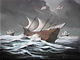
In most cases, the heaviest rain around a tropical storm or hurricane is dumped to the right of its
track. Naturally, the slower a tropical system moves, the greater the rainfall a location can
expect. When a cyclone interacts with old frontal boundary, a secondary rainfall maximum will
occur at and to the north of the boundary in question. Luckily, Louisiana has very little
topography, which makes rainfall amounts above 30" and landslides exceedingly rare events.
When a tropical cyclone transitions to a non-tropical low, dry air will wrap around the southern
and eventually eastern side of the storm. Maxima in rainfall will occur just west and distant to
the east of the track; the least amount of rain will fall in the system's "dry slot", a relatively
cloud-free area south/southwest of a non-tropical low. Severe weather such as downbursts,
tornadoes, and hail are more commonly seen as dry air intrudes into the cyclone's circulation.
In any event, rain will fall more distantly to the east of the center than it will to the west.
Upward vertical motions/warm air advection will occur to the east of the center, while
subsidence/cool air advection will occur to the west. This leads to a sharp contrast in weather to
the west of the point of landfall, between continuous heavy rain with high temperatures hovering
near 80, and sunny skies seen just to their west with high temperatures at or above 100 degrees.
Below is a table showing the ten highest rainfall amounts ever reported in Louisiana with
tropical cyclones.

                           Amount    Location               Dates
                           33.71" Crowley              8/06-10/1940
                           31.66" Abbeville            8/06-10/1940
                           29.92” Thibodaux            6/5-11/2001
                           29.65" Lafayette            8/06-10/1940
                           25.67 Winnfield             6/23-7/7/1989
                           22.39" Terrytown            9/10-14/1998
                           21.30" Logansport           7/22-26/1933
                           21.00" Larto Lake           8/29-9/5/2008
                           19.26" Morgan City          9/15-19/1943
                           18.30" Vinton               9/15-20/1963

                                                 5
Fatalities. The further you go back in time, the more people died from hurricanes. In the
Twentieth century, there was a steep dropoff in the number of deaths from cyclones due to
timely warnings by the National Weather Service, and also by information campaigns by the
public and private sector about the dangers of these storms. Katrina (2005) shows that there is
still much to do in regards to education and evacuation efforts for New Orleans. Below shows
the ten most deadly storms ever to effect Louisiana.
Fatalities Dates
2,000 10/1-2/1893
1,577 8/29/2005
526 6/27/1957
353 9/20/1909
275 9/29/1915
218+ 8/10-12/1856
110 10/12/1886
81 10/3/1964
51 9/19-20/1947
47 8/11/1860
Movement. During most months of the hurricane season, tropical cyclones move northwest into
the Pelican State. This is mainly due to the wind flow around the Azores/ Bermuda high
pressure system, which is strongest in July. In June and October, storms are more likely to move
in from the south and southwest. Cold fronts invading the state from the north and west would
cause winds across the Bayou state to become south and southwesterly, quickly picking up any
low pressure system lurking in the Gulf at the time.
Storms are most likely to stall across southwest Louisiana than any other portion of the state. A
climatological "col area" referring to an area between distant low/high pressure cells where
winds are nearly calm, exists across southwest Louisiana and southeast Texas during the
summer. The Bermuda high (outside July) is normally too far east to exert much of a
north/northwesterly motion on a storm while the Mexican Plateau low/trough is normally too far
south to steer a system to the west. Also, this region can lie between segments of the subtropical
ridge centered over the Southwest United States and near Bermuda, leaving the flow pattern aloft
weak. This can cause storms to stall for days across that region; Juan (1985), Claudette (1979),
and Allison (1989) are the most recent storms to stall near the Sabine River.
The list of hurricanes over the next few pages was compiled from numerous sources. The
relative lack of storms before 1829 is due to population mainly being centered around New
Orleans, and a lack of records from the few towns that existed elsewhere. The region now
known as the state of Louisiana wasn’t even settled until 1699. Many ships that may have
encountered storms during the early period of this history took their secrets with them to the
bottom of the Gulf of Mexico.
6On average, since 1851, 0.7 tropical cyclones of tropical storm strength (2 tropical storms
every 3 years), of which 0.3 are hurricanes (or one hurricane per 3 year period) should be
expected somewhere within the state. A hurricane should make a landfall every 2.8 years. On
the next page is a table of how many tropical storms and hurricanes have made a landfall per
decade in Louisiana since 1851, using statistics from the National Hurricane Center in West
Miami, Florida.
Tropical Cyclone Strikes by The Decade
Decade Hurricanes Tropical Storms Total
1850’s 2 0 2
1860’s 6 2 8
1870's 3 4 7
1880's 6 2 8
1890's 3 5 8
1900's 2 4 6
1910's 2 3 5
1920's 3 2 5
1930's 2 5 7
1940's 3 7 10
1950's 2 7 9
1960's 4 0 4
1970's 4 2 6
1980's 4 2 6
1990's 2 1 3
2000’s 6 6 12
=== === ===
54 52 106
7Louisiana Hurricanes - 1527 through 2009
Date Name Landfall Wind Category Dead Min Cent Pres
1527, 10/23 - Mouth of MS - - - -
1722, 9/22-4 - New Orleans - - - -
1740, 9/23 - Mouth of MS - - - -
1772, 9/02 - West of Mobile - - - -
1776, ? - New Orleans - - - -
1778, 10/7-10 - Mouth of MS - - - -
1779, 8/18 - New Orleans - - - -
1779, 10/7-10 - New Orleans - - - -
1780, 8/24 - New Orleans - - - -
1781, 8/23 - New Orleans - - - -
1794, 8/31 - New Orleans - - 1+ -
1800, 8/? - New Orleans - - - -
1811, ? - New Orleans - - - -
1812, 8/19-20 - Isle Dernieres - - 45 -
1813, 8/19 - N Gulf Coast - - - -
1819, 7/25-8 - Bay St. Louis - - 43 -
1821, 9/15-7 - Bay St. Louis - - 35 -
1831, 8/16 Great Barbados Isle Dernieres - - 1500 -
1837, 10/5-7 Racer’s Storm Cameron - - 105 -
1846, 4/03 Extratropical? Mouth of MS - - - -
1852, 8/26 Number 1 Pascagoula, MS 115 3 - 961
1855, 9/15-16 Number 5 Mouth of MS 125 3 - -
1856, 8/10-2 Isle Dernieres Isle Dernieres 150 4 200+ 934
1860, 8/11 Number 1 SE Louisiana 125 3 47 -
1860, 9/14-5 Number 4 Mouth of MS 105 2 - -
1860, 10/2-3 Number 6 Atchafalaya 105 2 13 -
1865, 9/12-3 Number 4 Johnson’s Bayou 105 2 23 -
1866, 7/12-13 Number 1 Louisiana Coast 105 2 - -
1867, 10/3-4 Number 7 Venice 105 2 - -
1871, 10/1-4 Number 7 Galveston, TX 80 1 4 -
1879, 8/22-3 Number 3 High Island 105 2 2 964
1879, 9/01 Number 4 Morgan City 120 3 1 -
1882, 9/14 Number 3 Sabine Pass 105 2 - -
1886, 6/13-4 Number 1 Sabine Pass 100 2 - -
1886, 10/12 Number 10 Sabine Pass 120 3 110 -
1887, 10/16-9 Number 13 SE Louisiana 85 1 - -
1888, 8/18-20 Number 3 SE Louisiana 110 2 - -
8Date Name Landfall Winds Category Dead Min Cent Pres
1893, 9/6-8 Number 8 Morgan City 100 2 - -
1893, 10/1-2 Number 10 Mouth of MS 130 3 2000 948
1897, 9/12 Number 2 Beaumont 85 1 - -
1900, 9/7-8 Galveston HU Galveston, TX 145 4 0 936
1901, 8/14-5 Number 4 Grand Isle 90 2 10 973
1906, 9/26 Number 6 Pascagoula 110 2 - 958
1909, 7/21 Number 4 Freeport, TX 115 3 2 959
1909, 9/20 Number 8 Thibodaux 120 3 353 952
1915, 8/15-7 Number 2 Galveston, TX 130 3 - 940
1915, 9/29 Number 6 Lockport 130 3 275 944
1916, 10/18 Number 14 Pensacola 110 2 - 970
1918, 8/06 Number 1 Cameron 120 3 34 955
1920, 9/21-2 Number 2 Isles Dernieres 100 2 - 975
1923, 10/16 Number 7 Point Au Fer 80 1 - 983
1926, 8/25-7 Number 3 Houma 115 3 25 959
1934, 6/16 Number 2 Morgan City 80 1 7 966
1938, 8/14 Number 2 Cameron 75 1 1 1001
1940, 8/6-10 Number 2 Cameron 80 1 6 972
1941, 9/22-24 Number 2 Texas City, TX 120 3 - 958
1942, 8/19-21 Number 1 Galveston, TX 80 1 - 969
1943, 7/26-27 Number 1 Galveston, TX 100 2 - 969
1947, 9/19 Number 4 New Orleans 80 1 51 966
1948, 9/3-4 Number 5 Timbalier Bay 80 1 - 989
1956, 9/24 Flossy Grand Isle 100 2 8 980
1957, 6/27 Audrey Sabine Pass, TX 145 4 526 946
1960, 9/14 Ethel Port Eads 90 1 - 981
1961, 9/11 Carla Port Lavaca 145 4 39 931
1964, 10/3 Hilda Salt Point 115 3 81 959
1965, 9/10 Betsy Grand Isle 125 3 0 941
1969, 8/17-18 Camille Pass Christian 190 5 - 909
1971, 9/16 Edith Pecan Island 100 2 3 977
1974, 9/7-8 Carmen Point Au Fer 120 3 3 937
1977, 9/6 Babe Cailliou Bay 75 1 - 995
1979, 7/11 Bob Terrebonne Bay 75 1 1 986
1985, 8/16 Danny Pecan Island 90 1 0 988
1985, 9/02 Elena Gulfport 115 3 19 959
1985, 10/29-31 Juan Atchafalaya 85 1 - 971
1986, 6/26-7 Bonnie Sabine Pass, TX 85 1 1 992
1988, 9/09 Florence Port Eads 75 1 - 988
1992, 8/26 Andrew Atchafalaya 115 3 2+ 955
1995, 10/04 Opal Pensacola, FL 115 3 0 942
1997, 7/18 Danny Grand Isle 85 1 - 988
9Date Name Landfall Winds Category Dead Min Cent Pres
1998, 9/27-28 Georges Pascagoula, MS 110 2 2 987
2002, 10/03 Lili Vermilion Bay 75 1 - 969
2005, 8/29 Katrina Mouth of the MS 125 3 1577 923
2005, 9/24 Rita Johnson’s Bayou 115 3 - 935
2007, 9/13 Humberto Vinton 75 1 - 989
2008, 9/01 Gustav Mouth of the MS 100 2 - 961
2008, 9/13 Ike Point Bolivar, TX 75 1 - 951
10Spanish Conquistadors and the Storm of 1527
Beginning in the year 1519, Spanish conquistadors began
plundering the New World for the sake of their motherland. Names
such as Ponce de Leon, Fernando Cortes, and Coronado began
exploring the area around the Gulf of Mexico and sent a “quinto”,
Spanish word for one-fifth, of their earnings to the king. To the left
is an artist’s rendition of a Spanish galleon, which would normally
to used to send the royal “quinto” back to Spain.
October 23rd, 1527: The earliest reference that can be found to a storm in the Gulf of Mexico
occurred on a voyage of Panfilo de Narvaez, whose nemesis was Fernando Cortes. His luck
usually turned out to be bad, and this mission was no exception. He was sent to settle Florida,
until forced to leave by hostile natives and hunger.
His five boats of less than 250 men hugged the coast and sailed westward. As they were
passing the Mouth of the Mississippi river, a storm caught the barges and “tossed them like
driftwood’ (ChiPMan). This occurred nearly 155 years before La Salle “rediscovered”, and then
lost the location of, the Mouth of the Mississippi river
Hurricanes of the Eighteenth Century
Hurricane dates occurring up to 1752 converted from Julian to Gregorian calendar
September 22-24th, 1722: This is the first well-documented hurricane to have hit Louisiana.
It initially moved through the Lesser Antilles on September 11th, later making landfall west of
the Mouth of the Mississippi on the 23rd, then passing through Central Louisiana. This same
storm most likely recurved northeast into South Carolina, as they reported 3 days of flooding
rains around the 27th.
Winds of hurricane force lasted fifteen hours beginning at 10 PM on the 22nd and ending
shortly after noon on the 23rd. Storm surges were three feet at Bayou St. John and eight feet in
the Mississippi River. Thirty six huts were destroyed, including the area hospital. These
buildings were hastily constructed in 1717-18 when New Orleans was initially selected to be the
capital of the Louisiana Company after a hurricane devastated Dauphin Island (Sullivan). The
St. Louis church was destroyed. Food crops were lost in Biloxi. This storm was responsible for
the moving of Mobile from 27 miles above the Mouth of the Mobile River to its present day site.
Ships were reported to be sunk in the harbor during this hurricane. Three piroughs loaded
11with fowl, corn, and other goods were lost up towards the Tensas. The level of the Mississippi
river rose eight feet due to the hurricane. In 1718, a three foot high levee was built to protect
New Orleans from both river and tide overflow. This proved inadequate, as older area
settlements used the devastation of New Orleans in the “Great Hurricane of 1722"
as final proof of that city’s unsuitability as the capital of Louisiana, following a great flood by
only three years.
A “rude little fort” was built in the marshes near the Mouth of the Mississippi River. This
location was discovered by Sieur de la Salle in 1682, lost, then found again before being
inhabited by 1699. It was named La Balize, french for “The Seamark”. In 1721, the first
lighthouse-type structure, rising 62 feet out of the muck and mire, was constructed at that
location. It was one of the first permanent settlements inside the current boundaries of the state
of Louisiana.
September 23rd, 1740: Hurricane struck Mouth of the Mississippi River. Destroyed a large
portion of the crops and left many colonists without shelter. The storm, along with others
following it in the 1740's, removed all traces of the original habitation at La Balize. A new
island was formed during the same time frame, called San Carlos. On this island, the Balize
was re-established.
September 4th, 1766: A hurricane strikes the Texas coast near Galveston and plays a role
in early Louisiana history. The ship Constante was lost in the storm about 45 miles east of
Calcasieu Pass, and the nearby bayou was named “Bayu del Constante”, or Constance Bayou
(Morgan).
August 31st-September 4th, 1772 (Bernard Roman’s Hurricane): Hurricane originating
near Jamaica on the 28th of August moved north and northwest into the Central Gulf Coast just
west of Mobile. Its effects were far reaching. In Pensacola, it destroyed most of the wharves.
The most devastation occurred in the vicinity of Mobile and the Pasca Oocolo River. Being on
the west side of this storm, the worst innundation occurred at the back of the Chandeleurs, Grand
Gozier, and Breton Isles and cut new channels within the islands. New Orleans itself enjoyed a
sunny day with light winds, though tides along the coast ran above normal.
All shipping at the Mouth of the Mississippi was driven into the marshes. This included the
ship El Principe de Orange, which only had 6 survivors. The Spanish merchant brigantine
Nuestra Señora del Amparo was also wrecked.
1776: A hurricane struck New Orleans. It produced some damage.
October 7-10th, 1778: There was a great storm surge that destroyed the establishments of
the Balize, Bayou St. John, and Tigouyou in the Louisiana delta. All structures were wiped out
of existence.
12August 17-18th, 1779: A hurricane made landfall at New Orleans. At the time, Spain had
declared war on Great Britain. Almost all of Bernardo de Galvez’ ships (Governor of New
Orleans) that were to be used to secretly seize the British post at Baton Rouge were grounded or
destroyed, thus ruining his plans for invasion until the 27th. The only ship that escaped disaster
was El Volante. Among the ships wrecked was the America La Reseda. Some of the ships were
found in the middle of woods after the storm!
Wind and rain began on the night of the 17th. Full violence of the storm was attained by
3 am. All houses, piroughs, barges, and boats were decimated; these included an American
Frigate, the Morris. This vessel was loaded with gunpowder to be used in the American
Revolution against the British in Illinois (Barnes). Fields were leveled and all crops, stock, and
provisions were lost.
During this storm, William Dunbar made observations that uncovered the true nature of
tropical storms and hurricanes; that they had a progressive forward movement and that the
winds revolved around a vortex at the center. He witnessed the 5-6 minute calm at New Orleans,
before the wind reversed and equaled its previous fury (Sullivan). His findings were presented to
the American Philosophical Society in 1801.
October 7-10th, 1779: A hurricane is reported to have affected New Orleans. This storm may
be the same as the one listed above in 1778 with the same dates.
August 24th, 1780: A hurricane worse than the one in August 1779 swept over the province
of Louisiana striking New Orleans; destroying crops, tearing down buildings and sinking every
vessel and boat afloat on the Mississippi River and on area lakes...the town was leveled. It was
during this storm that Dunbar noted the tornadoes formed around tropical storms and seldom
lasted more than 5 to 10 minutes.
This was of no comfort to the inhabitants of the area, who were distraught after these two
storms, an excessively cold winter and a very rainy summer. This residents wrote the Spanish
sovereign not to abandon the country, regardless of the adverse blows of nature.
August 23rd, 1781: A hurricane is reported to have struck New Orleans. It may be a
reference to the previous storm, as no data as been found to support its presence.
August 18th, 1793: A strong tropical storm hit New Orleans and destroyed unharvested crops
and devastated rural sections of the province. Four merchantmen were wrecked on the
Mississippi; two were American ships from Philadelphia.
August 31st-September 1st, 1794: A hurricane that had moved through Cuba on the 27-28th
struck New Orleans on the 31st and produced considerable crop damage. The storm surge
moved inland from Balize westward to the Plaquemines, as much as 10 feet in places, totally
engulfing Fort St. Phillip, drowning their chief engineer. Large hail was also noted in the
13storm; an unusual event in a tropical cyclone. Nine hours of high wind tormented what is now
Avoyelles Parish on September 1st as the storm continued marching northward. Many lives,
cattle, and horses perished in the storm.
August 1800: A hurricane is reported to have struck New Orleans.
Hurricanes of the Early Nineteenth Century
1811: Hurricane struck New Orleans.
August 19-20th, 1812: A hurricane struck just west of New Orleans. At 5 PM on the 19th,
winds began out of the northeast in New Orleans. Winds increased to a “perfect hurricane” at
11 PM. Winds abated after 2:30 PM on the 20th. Nearly all buildings suffered, including those
made of brick. The market house in New Orleans was demolished. The Church of the Covenant
lost its roof. All window panes at City Hall were broken. Fifteen feet of water covered the city.
Extensive damage occurred to trees. The levee was destroyed. The storm surge submerged
areas south of the city. Plaquemines parish was under as much as 15 feet of Gulf waters, where
45 drowned (National Intelligencer). Sugar crops suffered severely.
Damage was significant to their naval base. The U.S. brig Enterprise was shoved ashore,
dragging her anchors. The Viper lost her main mast, and suffered additional damage. Fort St.
Phillip in Plaquemines parish went fully underwater, with most within the fort drowning. Only
six of 60 ships on the Mississippi river were considered worth repairing. At least 10 perished
from the ship Harlequin. The beach of Lake Pontchartrain was strewn with vessel fragments,
their cargo, and victims of the cyclone. Nearly 100 people died during the storm. Losses totaled
$6 million.
Some public panic set in when after the storm rumors spread that the British had taken over
Fort St. Phillip; this storm struck during the thick of the War of 1812 and the fort was controlled
by Americans at the time. In fact, the British fleet approaching the area was scattered widely
across the Gulf during the storm. Fort St. Phillip itself went underwater.
August 19th, 1813: A hurricane affected Gulf coast and was considered very destructive.
July 25-28th, 1819: Hurricane affected coast from Louisiana to Alabama. It struck Bay St.
Louis. New Orleans was at the fringe of the storm and suffered no severe damage. Ships at
the Balize suffered a strong gale for 24 hours that only grounded three ships. Lakes
Pontchartrain and Borgne rose five to six feet during the storm, with farms along the lakes
flooded by the storm tide. Forty one lives were lost on the U.S. Man of War schooner
Firebrand, a 150 ton gun ship, while it lay off the west end of Cat Island. At
14least 43 people died in all.
September 15-17th, 1821: A second, much larger yet weaker
hurricane struck near Bay St. Louis. The gale continued for over
24 hours at New Orleans, beginning at 6 PM on the 15th and
Boufouca. A dozen willow trees were the main casualties there.
The storm was more damaging at Petite Coquille, where four
soldiers drowned when an eight foot storm surge overwashed the
island. The fort there was nearly swept away. The schooner
Brisk was driven onto the Middle Ground in the Mississippi
Delta after becoming dismasted on the 16th (it was saved on the 23rd). The U.S. Schooner
Enterprize was cast away off Cat Island (Louisiana Courier). At least thirty-five lives were
claimed by the storm.
August 16-17th, 1831: The Great Barbados hurricane, very
destructive, hit just west of Last Island, just west of Baton
Rouge. It was considered the strongest hurricane across
southeast Louisiana since 1812 and killed 1500 people along its
path from Barbados to New Orleans. A fishing village on Grand
Isle was destroyed when the tide rose six feet. Barataria saw the
greatest damage as the town and its inhabitants were swept out to
sea (Louisiana Courier). Sugarcane crops suffered severely from
Baton Rouge to Pointe a la Hache. Orchards and gardens in
Plaquemines parish sustained considerable damage. A total of 260 perished statewide, with 150
from Barataria.
August 28-29th, 1831: A strong tropical storm struck southwest Louisiana. High tides were
seen west of Lake Borgne...gales raged in New Orleans overnight on the 28-29th . Gales were
much more severe near the Sabine River and across central Louisiana near Opelousas and
Attakapes. Cotton was ruined in Baton Rouge and Alexandria due to the heavy rains and winds.
High winds were noted as far northwest as Fort Jessup, southwest of Natchitoches.
October 5-7th, 1837 (Racer’s Storm): The Racer’s Storm hit Matamoras, Mexico and caused
great devastation to the Texas coast while recurving northeast and striking Louisiana just east of
Cameron on the 6th. It then moved east along the Gulf coast and headed out into the Atlantic by
the 10th (track on the right). Storm surges of 8 feet above the normal high tide on Lake
Pontchartrain. The original wooden Bayou St. John lighthouse , the first of its kind built by the
United States outside the original 13 colonies, was swept into obscurity.
New Orleans experienced a gale on the 5th and 6th , destroying chimneys, awnings, and many
area roofs. The City Exchange on Lewis Street, which was under construction at the time,
suffered much damage. All wharves along the Mississippi coast were washed away with the
tide. The storm caused widespread flooding and considerable damage to shipping; all boats,
including four steamboats, perished in the storm.
15Lower portions of New Orleans were submerged. Many buildings were damaged or carried
away. Crops were seriously damaged along both sides of the Mississippi, particularly sugar
cane and cotton. Six lives were lost. See Texas Hurricane History for more on the earlier
history of this storm.
September 14th, 1839: This storm struck Charley’s Lake (later known as Charleston, Lake
Charles). An “appearance of rain” was noted on the 14th. Rain began on the 15th with a “hard
wind”. The rainfall increased in intensity on the 16th. By the 17th, the rain and wind subsided,
yet cloudiness lingered. The only reference found of this storm was in the T. Rigmaiden Diary.
June 19th-23rd, 1840: Another possible reference to a tropical cyclone for Charley’s Lake
(Charleston, Lake Charles) was found in the Rigmaiden Diary. An all-day rain began on the 19th
and continued for days. Winds increased by the 21st, as corn was “blown down in the field”.
The center passed west of the village, as a “hard south wind” blew across the region. Rain
continued through the 23rd.
June 11-15th, 1844: Charleston (Lake Charles) experiences another storm. During the 10th
and 11th, threatening skies brought the promise of rain. On the 12th they delivered; a “very hard
rain” developed. A continuation of the deluge on the 13th led to the bending of area corn stalks
and the washing away of a bridge. Rain continued through the 15th.
April 3rd-4th, 1846: A hurricane hits Balize, near the Mouth of the Mississippi. The system
could have been a strong nontropical low similar to the March storm of 1993 due to the date of
occurrence. The storm cut a boat channel between Cat Island, a place named for what the French
thought were cats on the island (but turned out to be raccoons) and its lighthouse.
Southwest Louisiana saw the fury of this cyclone as well. It rained throughout the 3rd with a
“very hard wind”. Flooding developed at Charleston (Lake Charles) of the 4th, causing waters to
encroach upon area residences and sweeping away fences. Six inches of rain were measured
with the storm. Intermittent rain continued through the 7th.
September 5-8th, 1846: A “hard rain” developed in Charleston (Lake Charles). Windy
conditions on the 6th were accompanied by a noticeable rise on area rivers. Rain continued
through the 7th and the river stage peaked on the 8th or 9th. No significant damage was noted.
The rains throughout Louisiana that year made sugar cultivation difficult; most of it fell between
February and August. Yields dropped 25-50% as Baton Rouge totaled 116.6 inches of rain that
year (Wade, Lawson).
16Hurricanes of the Late Nineteenth Century
August 25-26th, 1852: A tropical storm formed north of Haiti on the 19th before moving west
through the Florida Straits, and then northwest into the Mouth of the Pascagoula River on the
night of the 25th. It was hardly noticed on Lake Pontchartrain. Four new channels were cut
through the Chandeleurs. The storm claimed the 55 foot tall Chandeleur Island lighthouse and
replaced the area with a broad, ten-foot deep lagoon (Cipra). The keepers of the light were
rescued 3 days later, on the verge of starvation. The schooners Josephine and Walter M. went
ashore Cat Island.
September 15-16th, 1855: A hurricane swept out of the Gulf across Fort St. Phillip and Lake
Borgne, before moving inland in Mississippi. It was considered the worst hurricane since 1819
and was felt as far east as Apalachicola Bay. Its pressure pattern was compact as the pressure at
New Orleans fell to a mere 29.93” at 7 AM on the 16th (Henry). At Proctorville, the wharf and
bathhouses fell victim. Water was four feet deep on Proctor’s Landing. At Lake Borgne, water
began to rise during the afternoon of the 15th. A “smart breeze” was blowing at sunset. It had
increased to a “perfect hurricane” by midnight. A number of homes were destroyed.
At Cat Island, the light keeper’s dwelling was wrecked and its lighthouse was left in “severe
peril”. Most structures along the Mississippi Coast were swept away. The Atchafalaya and Ship
Shoal lightships were torn from their moorings and grounded. Both lightships were repaired
and returned to service in 1856 (Cipra). The ship Venice was pushed onto the banks of the
Mississippi by the strong gale and sprung a leak. The steamer J.S. Chenoweth sank to the bottom
of the Mississippi.
August 10-12th, 1856: Hurricane strikes Isle Dernieres, Last Island, a pleasure resort south-
southwest of New Orleans. The highest points were under five feet of water. The resort hotel
was destroyed, along with the island’s gambling establishments. Over 200 people perished,
and the island was left void of vegetation and split in half. Only one terrified cow remained
on the island after the catastrophe. Last Island is now only a haven for pelicans and other sea
birds. The steamer Nautilus foundered during the storm. The lone survivor clung to a bale of
cotton and washed ashore sometime later.
Every house in the town of Abbeville was leveled. Rain from the storm flooded the
Mermentau River and destroyed crops along bottom lands. Area rice fields in Plaquemines
parish went under several feet of salt water. Nearly all rice was lost to the storm. Orange trees
were stripped of their fruit. The rain total at New Orleans reached 13.14". In Lake Charles,
it rained most of the day on the 12th.
1860: Number 1 on August 11th: On the fourth anniversary of the Last Island Disaster,
another hurricane made landfall across southeast Louisiana. A twelve foot storm surge
17inundated the Mississippi Delta (Landsea, personal communication). The old site of Proctorville
(now Yscloski) had hardly a house that remained standing and its lighthouse was leveled. The
lighthouse at Bayou St. John was destroyed. The light keeper’s dwelling was demolished, and
the Cat Island tower was devastated. Cat Island was inundated, causing 300 cows to drown. The
Mississippi rose three feet during the storm.
Storm surges were seen eastward along the entire Mississippi shore. The sugar cane crop laid
in ruin. Trees were uprooted in Plaquemines parish at the Balize (Pilottown). Up to ten feet of
water invaded from the Gulf. Crops of rice and corn were entirely ruined. The influence of the
storm extended eastward to Pensacola, where it rained 3.03" and a strong gale ensued on the 11th.
Over 47 people died...damages totaled $260,000.
1860: Number 2 on September 14-15th: Another hurricane struck near the Mouth of the
Mississippi, worst at Pilottown. The gale raged for about 20 hours across extreme southeast
Louisiana, and large hail fell. Every building in Balize was either blown down by the wind or
washed away by the storm surge, which reached ten feet in height. The lower portions of
Plaquemines Parish were covered by several feet of water, drowning several people.
The third Bayou St. John lighthouse was damaged beyond repair. Tides rose to six feet above
the high tide mark. All wharves along the south side of Lake Pontchartrain were destroyed. But
it was no better in Mississippi...the lighthouse at Bay St. Louis was swept away along with one
of its hotels. In total, damages exceeded $1 million.
1860: Number 3 on October 2nd-3rd: A third hurricane within seven weeks produced severe
damage to houses, businesses, boats, and crops as far inland as Baton Rouge. Winds and tides
were similar to the previous cyclone in September. The storm made landfall at the Atchafalaya
Bay and swept northeast. It only carried with it a 12 to 15 inch storm surge at Port a la Hache;
the low level of inundation was likely due to its rapid movement. The sugar crop, along with the
machinery employed in producing it, laid in ruin. Heavy losses were reported in Vermilion,
Feliciana, Albermarle, Bayou Lafourche, Pointe Coupee, St. Bernard, and Terrebonne as well.
Eleven miles of railroad track were washed out near New Orleans, where the rain total was 5.02
inches during the storm. Many livestock and 13 lives were lost.
This system continued northeast and produced the highest winds Natchez had seen since the
Devastating Tornado of 1840. Trees fell in great numbers across Concordia Parish as they
experienced stiff north winds. Gales were seen eastward to Pensacola, as with the first storm of
1860.
September 28-October 1, 1863: A tropical storm made landfall in southwest Louisiana on
September 29th, and moved east-northeast across the state, becoming an extratropical cyclone
during its passage through Louisiana. Limbs were removed from trees by the wind at Sabine
Pass. The Yankee schooner Manhassett was captured by the Confederates at Sabine Pass as it
was driven shore by the cyclone. Two and a half days of rain within the Atchafalaya swamp
caused troops movements to come to a stand still at Morgan’s Ferry. The rains in Louisiana
18broke a drought at New Orleans, where winds initially kicked up dust across the city in advance
of the storm’s rain shield. In the wake of the storm, temperatures fell to comfortable levels
within the Crescent city.
Just on the Louisiana side of the Sabine River lies a vast expanse of marshland near the
coast. Within this region is the town of Johnson’s Bayou (now referred to as Johnson Bayou).
French fur traders traversed the area during the 1700's in order to barter with the local Native
American tribe, the Attakapas. The first permanent settler was Daniel Johnson, who arrived in
1790. Like other places in the South, cotton was their primary crop. It was cutoff and virtually
isolated from the outside world, until 1960.
September 12th-13th, 1865: This hurricane struck extreme Southwest Louisiana. It is
considered weaker than Audrey in strength and smaller in areal extent. Niblet’s Bluff was
completely destroyed. One person died in Johnson’s Bayou where many homes were leveled.
The area around Calcasieu (Big) Lake was inundated by the storm surge. Grand Chenier was
also put under water by the storm where several more people died. Fragments of furniture and
homes were found afloat several miles up the Calcasieu. Twenty-five people lost their lives to
the hurricane, most at Leesburg (Cameron).
The tides were high as far east as the Mississippi River, where rain and high winds were
noted on the 13th. Extensive flooding occurred in Feliciana Parish. The entire Balize settlement
and Pilottown were slowly abandoned in the years prior to the storm; everything left in the area
was obliterated. The ship Lone Star wrecked while in Galveston Bay, and vessels trying to save
the survivors almost foundered as well.
October 22nd-23rd, 1865: Hurricane affected Louisiana coast.
July 12-13th, 1866: A storm moved westward offshore Louisiana. At 28.5N 87.3W, a
three-masted schooner was seen dismasted on the 11th in heavy seas. Winds “blew hard” at
New Orleans for a few hours on the evening of the 12th. Tides increased until daybreak on the
13th.
The Timbalier Bay lighthouse saw the most action along the Louisiana coast. “Ugly,
threatening weather” hit on the 12th. Three feet of water surrounded the tower. Wave action
knocked away two brick piers, as 24 hours of pounding surf broke against the lighthouse. The
keeper became spooked by the combination of weather conditions and loneliness, and promptly
resigned (Cipra).
August 15-18th, 1866: On the 15th, the fringe of this system reached New Orleans.
Conditions became stormy with winds out of the northeast. The rain subsided by the 16th, but
breezy conditions continued. Steady rain set in again on the 17th at sunset. Southwest Pass saw
high tides and stormy weather on the 18th as the winds became southeast. New Orleans rained
19for the remainder of the day.
Proving the previous keeper at the Timbalier Bay lighthouse correct in judgement, “gale-
driven” seas again invaded from the Gulf of Mexico. The temporary light and nearby dwelling
house were demolished. The new keepers clung to a buoy for days, riding out the storm (Cipra).
October 3rd-6th, 1867: On the 1st, cloudiness set in at New Orleans as a fresh breeze
developed, accompanied by showers. A storm was discovered off the coast of Brownsville/
Clarksville on the 2nd. On that day, a regatta was held on Lake Pontchartrain. A “spanking
breeze” from the northeast and squalls played havoc with their race. During the 3rd, a gale
developed at New Orleans, and the city became flooded due to the high seas and heavy rains.
The saw mill and bath houses were blown away. At Milneburg, houses were swept away. The
storm recurved northeast and east, within 70 miles of the Texas and Louisiana coastline.
At the Mouth of the Mississippi, a “fearful gale” blew by midnight on the night of the 4th.
The pressure fell to 28.80" during the tempest. The river had been churned into a “seething
foam”. Telegraph lines in the area were downed. Three houses at Pilottown were leveled. The
system briefly made landfall near common day Venice, before moving east towards Florida.
The hurricane was severe, driving “pyramidal seas” against the Ship Shoal lighthouse,
strongly shaking the tower, and splashing oil for the light out of its reservoir. The light was
extinguished for six hours, and the lighthouse took on a northeast lean afterwards. The Shell
Keys lighthouse was demolished...its keeper was killed. The screw piles that connected the
Southwest Reef lighthouse to the Gulf bottom were bent and twisted.
The Spanish bark Carmen went ashore. A coal barge was sunk. The Eclipse became lodged
in mud. Heavy winds and rain continued through the 6th across southeast Louisiana. Rice crops
in Plaquemines parish experienced great damage.
October 3rd, 1868: A hurricane passed just offshore the southeastern tip of the state, before
hitting Apalachicola the next day. The West Rigolets lighthouse suffered $5000 in damage
during the storm.
Early September 1870: A storm flattened sugar cane throughout St. Mary parish (Wade).
Due to the date of occurrence, and extent of the damage, this may have been a tropical storm.
No other information has been found about this system.
June 2-3rd, 1871: A tropical cyclone that struck Galveston also impacted Louisiana. New
Orleans flooded due to the excessive rainfall, giving the appearance of a “submerged city” after
the storm.
June 8-9th, 1871: A second tropical storm made landfall, this time just west of Galveston.
Strong southeast winds were felt at New Orleans. Heavy rains began around 3 PM on the 8th. At
Berwick’s Bay, a “terrific gale” set in on the 9th. Southwest Pass also saw these strong winds.
20Rain fell in torrents across the area...aggravating the flooding from the storm the week before.
Milneburg went underwater. Lake Charles experienced winds approaching hurricane force.
Corn and cotton were in ruin...fruit trees were uprooted “by the score”. The old courthouse was
damaged beyond repair. Many cattle and hogs drowned in Leesburg, the town now known as
Cameron (Benoit).
A tornado touched down at Chatawa, 95 miles from New Orleans. It was 100 feet wide and
was on the ground 10 to 15 minutes. A school house was razed to the ground. Numerous trees
were uprooted, including 100 peach and pear trees. The schooner Confidence was sunk by the
storm at Manchac bridge. See the Texas Hurricane History for what the storm did across
southeast Texas.
October 1st-4th, 1871: Heavy rains and winds started across southeast Louisiana with this
cyclone on the 1st. Large trees were blown down. Walls of burnt buildings crumbled before the
storm’s fury. New Orleans saw “unprecedented rainfall” in the period between 6 PM of the 2nd
and 3rd; six to ten inches were measured. Homes were unroofed and telegraph poles fell.
Damage was estimated at $5,000.
Southwest Pass saw a “very heavy gale” from the southeast start at 10 PM on the 2nd,
becoming northeast by the 3rd. The pilot boats Louis Geran, Orientals, Hays, and Cornelia were
beached. The Robert Bruce was thrown ashore and became “a perfect wreck”. Its pilot and boat
keeper clung to the boat for 30 hours before being rescued by the tug Wicaco. Four on the Bruce
perished during the storm.
July 4th, 1874: A hurricane that struck the coast near Indianola, Texas also left its mark on
Louisiana. Torrents of rain fell in the city of New Orleans...setting a 24 hour rainfall record for
July of 7.52".
The creation of Port Eads. Attempting to made the Mississippi navigable, James Andrews
and James Eads embarked upon creating jetties to clear a deep channel to the Gulf of Mexico.
Direct communication by telegraph to New Orleans was established, and a small town named
Port Eads quickly developed in the river’s delta. Weather observing began at the site soon
afterward. The channel was used regularly by shipping in 1876 (Barry).
21September 15-18th, 1875: On the 15th, the fringe of this hurricane
first affected Louisiana. Ships foundered, even in the protected
harbor of New Orleans. The schooner Mabel sailed out of the Mouth
of the Mississippi river, never to be heard from again. On the 17th, a
strong south wind developed across southern Louisiana. As the
hurricane moved eastward out of Texas, Calcasieu and Lake Charles
saw the wind shift with “terrific force”. Tides at Shell Island were
higher than during the Isle Dernieres disaster of 1856.
In St. Mary parish, the “tremendous equinoctial storm” damaged cotton, prostrated sugar
cane, and cuased a thirty-four hour deluge that turned the surrounding prairie into a “vast sheet
of water” (Wade). Isle Piquant saw a number of houses destroyed and fences leveled. At New
Orleans, the squall came in from the west later that evening. Winds of 36 mph did a number on
the steamer Natchez. It collided with the ferry Louise, linked up with the boat and they drifted
down the Mississippi. After brushing past the C.H. Durfee and Belle Rowland, the Natchez was
re-secured. The pressure fell to 29.30" at Southwest Pass at noon on the 18th. The Greenleaf
dragged its anchor and went ashore.
August 22nd-23rd, 1879: This hurricane made landfall in Louisiana. At Lake Charles, winds
increased out of the northeast beginning at 9 AM on the 22nd, then veered to the east and
southeast after dark. According to the Lake Charles Echo, winds were sustained at 40 mph. The
Weekly Calcasieu Gazette reported that during the “night we had a perfect hurricane.” Several
old buildings were blown down and the spire from the Catholic Church was torn off. Trees were
uprooted; fences and chimneys were destroyed. Great damage was done to the rice crops,
gardens, and orchards.
In Cameron Parish, damage was greater. A “tidal wave” swept from the southeast across
the west bank of Calcasieu Pass, stranding no less than 12 vessels high and dry after the storm.
Some of the schooners were propelled far inland. The lighthouse was “wrenched” 6 inches to
the west, its beacon blown away. Two seamen were tossed overboard from the New York brig
Caseatell. Many of the dwellings were destroyed. Some floated away into the Gulf of Mexico
without a trace. Hundreds of cattle were rolled “head over tail,” struggling vainly to keep their
heads above water, yet still drowned. The new two-story church in Johnson’s Bayou was
leveled. The damage was considered far worse at Grand Chenier.
In Vermilionville (Lafayette), the steeple of the Catholic church fell in. Trees were
downed and crops of cotton were damaged. At Broussardville, the Catholic chapel was
severely damaged along with roofs being blown away and the schoolhouse moved several feet.
New Iberia and Franklin saw some homes destroyed and many roofs blown off. Scarcely a
building was left unharmed between Morgan City and New Iberia. Destruction to the sugar
cane and fruit crop was considered “appalling.” Extreme southeast Texas experienced the full
fury of this cyclone.
September 1st, 1879: This hurricane struck the coast just west of Morgan City only ten days
22after the last. In Abbeville, light rain began to fall on the night of the 31st. By 7 AM on the 1st, a
“perfect gale” was uprooting trees along with damaging homes and fences. Winds died down
after 3 PM. Bridges were washed away by the rain and flooding. Their Catholic church’s roof
partially fell under the weight of a tree, causing its bell to fall to the ground. Many trees toppled
across St. Mary and Iberia parishes.
Damage was greatest around Morgan City, where the pressure fell to 28.70". Sugar houses on
the Teche were damaged. The Centreville Catholic and the Morgan City Presbyterian churches
were flattened. Saw mills at Jeanerette were destroyed. The wind was so intense between
Morgan City and Jeanerette that trees were defoliated as if it was winter; estimated between 75
and 80 mph between New Iberia and Morgan City. Fifteen cabins, a couple churches, and the
local saw mill also fell victim to the storm. Berwick Bay rose nine feet and flooded all the
streets of Morgan City.
In Opelousas, crops were wrecked throughout the parish with over ½ of the cotton and most
of the corn in ruin. Trees were downed as well. The steamer Daniel Boone was sunk. The
steamers Sammy and E.W. Fuller were forced well inland; in the case of the latter, several miles
inland from Bayou Sale. Damage estimates were around $½ million. Twenty mules and five
cattle fell victim. One human life was lost.
September 9th, 1882: A hurricane affected extreme southeast Louisiana. Port Eads reported
92 mph winds and a pressure of 29.38" with the storm. One half of the rice crop in Plaquemines
Parish was destroyed by the Gulf inundation. At Quarantine, the ground was submerged; people
took refuge in the government wharehouse. When it made landfall in Pensacola, a great deal of
crops, shipping, and buildings suffered there as well.
September 14th, 1882: A strong tropical storm made landfall in Southwest Louisiana. That
night, a “hard wind and rain” visited Lake Charles, described as a “lively gale”. Port Eads had
winds up to 70 mph and a pressure of 29.38". Abbeville reported no damage with the storm.
June 13-21st, 1886: This marginal hurricane passed inland
near Calcasieu Pass (track on the right). The inundation of the
storm surge extended several miles inland, reaching its highest
point at 10 AM. Winds blew hard in Lake Charles, damaging ½
of the corn crop across southwest Louisiana. The storm was most
severe at Calcasieu Pass, causing extensive flooding. An English
barge was blown ashore, and several schooners experienced much
damage. The schooner Agnes was left on the north side of Big
(Calcasieu) Lake.
Sabine Pass was covered by seven feet of water. An eight foot
storm surge placed the Sabine Pass lighthouse under five feet of water. In Edgerly, several sheds
were leveled and roofs were blown off area homes. Johnson’s Bayou reported all stock drowned
and crops lost. A large watermelon crop laid in ruin; an orchard in the area had fruit “whipped
23off” the trees; twenty-five had considerable damage. A few outhouses were blown away. By the
21st, waters were at their highest on Lake Charles, flowing onto Ryan Street. Residents said the
water was “as high as it ever gets.”
More rain-induced flooding occurred further north. Marksville received heavy rains on the
15th and 16th, with significant flooding around Bayou Pierrite. Excessive rainfall was seen at
Alexandria; 21.4 inches there. In Jackson Parish, southwest of Monroe, the rains were a relief to
crops yet still caused flooding of area creeks.
October 11-13th, 1886: Another more powerful hurricane
hit near Sabine, Texas (track on the right). The innundation
from the Gulf extended 20 miles inland at the point of
landfall. It blew “almost a hurricane” for 36 hours, from the
night of the 11th until the morning of the 13th. Port Eads
reported 70-100 mph winds at 7 PM on the 11th. The
Mississippi jetties were demolished. New Orleans had a
pressure of 29.79". At Southwest Pass of the Calcasieu
River, near Leesburg (Cameron), the water got as high as
nine feet deep at the lighthouse. All cattle and crops were
gone after the storm.
Cameron Parish suffered greatly as the storm was worst at Johnson Bayou. The Peveto
Beach hotel might have been washed away if a large number of cattle had not taken refuge in
the building! Winds began to increase out of the south at 4 PM, becoming a gale by 7 PM, and
a full-blown hurricane by 8 PM. By 11 PM, a storm surge of 12 feet had swept inland and the
first buildings began to fall. Survivors sought refuge in buildings or by clinging to floating
debris. All waters had receded by noon the next day.
Nearly every house in the vicinity was removed from its foundation. The storm washed away
the lighthouse keeper’s brick quarters at the old Sabine Pass lighthouse, on the Louisiana side of
the Sabine River. Many families abandoned Johnson’s Bayou soon after the tempest. The twin
city of Radford was destroyed, never to be rebuilt. Most of its refugees fled into Texas. Seven
thousand area cattle perished in the storm. Between 175-200 perished in all, 110 of which
were from Johnson’s Bayou.
The storm wreaked havoc to crops statewide, especially area cotton and rice fields across
southwest Louisiana; half the corn crop was lost in Sugartown. One unoccupied house at the
edge of town in Lake Charles was blown down. In Plaquemines Parish, the entire rice crop was
in ruin. Wreckage along the Lower Mississippi coast was reported to be “terrible”, causing $250
thousand in damage. Considered similar to Audrey in its effects. Texas endured its share of
destruction as well.
24October 16-19th, 1887: A hurricane struck southeast Louisiana.
On the 16th, a strong northeast wind blew across the area. Winds
continued strong until the 18th, when winds rose to “a regular storm”.
Rain was steady until the 19th when skies cleared, but the wind
remained. The cyclone caused much destruction in New Orleans,
where the pressure fell to 29.22"; they received their heaviest rain in
years.
Great damage was done to cane and cotton crops around Abbeville. Iberville Parish had
considerable damage to area outhouses and the sugarcane crop. In Algiers, trees were blown
down. Such flooding occurred that people had to “wade to work”. On the 29th, a call went out
in the Abbeville Meridional for the formation of a “New State Weather Service” for Louisiana;
over twenty states had formed such an organization under the U.S. Signal Corp as of that time.
August 18-20th, 1888: The “severest and most extensive”
hurricane that had impacted Louisiana since the Racer’s Storm
in 1837 affected much of northern Gulf coast (track on the left).
In New Orleans, all electric light, telegraph, and phone wires
went down on Sunday night. The height of the storm was
Monday morning. Winds of 90 mph howled through New
Orleans.
The Teche also felt the storm. Sugar houses and sheds were
blown down. Franklin had many homes with roofs blown off
and leveled. Two churches in Morgan City were almost
demolished. Local wharves were also damaged. The rice crop
suffered severely. Much wind damage was noted in
Plaquemines, St. James, Donaldsonville, Houma, Convent, and
Tigerville (which was renamed Gibson two weeks later after
the senior Louisiana Senator in power at the time).
Rain totals of three to four inches were common across southern and central Louisiana. New
Orleans set a 24 hour rainfall record for August on the 19th, when 8.9" of rain fell; 14.14" was
measured that week. Almost the whole city was submerged during the tempest. Maurepas had
11.48" of rain. All this water led to extensive flooding in Mandeville.
Rice, sugarcane, corn, and cotton crops were a total loss in sections of southern Louisiana.
Grand Coteau lost much of its fruit crop. Several churches and homes were completely
destroyed. Steamboats and sail boats were driven ashore. The steamers Keokuk, W.G. Little, and
Laura sank during the tempest. Trees were uprooted across the area. Several people perished in
the storm. Damage ran about $2.7 million with the worst occurring in southeast Louisiana. Half
the total was due to crops, another third due to coal sunk in New Orleans harbor.
25September 22nd, 1889: A hurricane accelerated northeast out
of the Gulf of Mexico and struck the southeastern tip of the state
near Venice before moving into the western Florida panhandle
(track on the right).
September 6-8th, 1893: This hurricane produced a great
amount of damage to a small area of the state as it moved northeast
out of the Gulf of Mexico into southeast Louisiana. Lockport in
Lafourche Parish was partially destroyed; the storm there lasted
from the night of the 6th until the afternoon of the 8th. Abbeville
saw a stiff east breeze on the 7th that became a gale that afternoon
and evening with heavy rain; over five inches in all.
The heaviest rains were confined to southeastern sections of the
state; highest totals were from Franklin (15.20") and
Donaldsonville (10.69"). Twenty-four hour rainfall records were
set for the month of September at Donaldsonville (7.74" on the 7th), Emilie (8" on the 6th), and
Wallace (9.29" on the 7th). St. Martin and St. Mary Parishes had the worst losses in the state to
cotton, rice, and sugar. Oranges saw extensive damage in eastern Feliciana Parish.
The Deadliest Hurricane in Louisiana History:
Chenier Caminanda, October 1893
October 1st-2nd, 1893 (Chenier Caminanda
Hurricane): An unheralded storm of great violence
moved from the Gulf across the southeastern United
States (track on the right). It devastated about 500 miles
of coastline from Timbalier Bay to Pensacola.
Settlements along Lake Borgne, the Lower Mississippi,
and the islands along the coast from the mouth of Bayou
Lafourche east to the Chandeleurs saw the brunt of the
hurricane. Landfall was between New Orleans and Port
Eads on October 1st. Winds of 100 mph were estimated
at Grand Isle and at Pointe a la Hache. High winds were
noted as far west as Abbeville. A schooner four miles
north of Pascagoula reported a pressure of 28.65".
At dusk on the 1st, hurricane force winds overspread the coast. At 10 PM., as winds
continued to increase, water began covering the coastal island. A gigantic wave then crashed
26You can also read