Texas Hurricane History - David Roth National Weather Service Camp Springs, MD
←
→
Page content transcription
If your browser does not render page correctly, please read the page content below
Texas Hurricane History
          David Roth
    National Weather Service
      Camp Springs, MD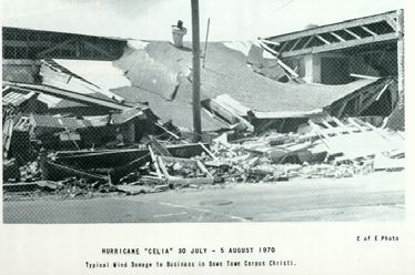
Table of Contents
Preface                                                                        3
Climatology of Texas Tropical Cyclones                                         4
List of Texas Hurricanes                                                       8
Tropical Cyclone Records in Texas                                             11
Hurricanes of the Sixteenth and Seventeenth Centuries                         12
Hurricanes of the Eighteenth and Early Nineteenth Centuries                   13
Hurricanes of the Late Nineteenth Century                                     16
   The First Indianola Hurricane - 1875                                       19
   Last Indianola Hurricane (1886)- The Storm That Doomed Texas’ Major Port   22
   The Great Galveston Hurricane (1900)                                       27
Hurricanes of the Early Twentieth Century                                     29
   Corpus Christi’s Devastating Hurricane (1919)                              35
   San Antonio’s Great Flood – 1921                                           37
Hurricanes of the Late Twentieth Century                                      45
Hurricanes of the Early Twenty-First Century                                  65
Acknowledgments                                                               71
Bibliography                                                                  72
Preface

   Every year, about one hundred tropical disturbances roam the open Atlantic Ocean, Caribbean
Sea, and Gulf of Mexico. About fifteen of these become tropical depressions, areas of low
pressure with closed wind patterns. Of the fifteen, ten become tropical storms, and six become
hurricanes. Every five years, one of the hurricanes will become reach category five status,
normally in the western Atlantic or western Caribbean. About every fifty years, one of these
extremely intense hurricanes will strike the United States, with disastrous consequences.

    Texas has seen its share of hurricane activity over the many years it has been inhabited.
Nearly five hundred years ago, unlucky Spanish explorers learned firsthand what storms along the
coast of the Lone Star State were capable of. Despite these setbacks, Spaniards set down roots
across Mexico and Texas and started colonies. Galleons filled with gold and other treasures sank
to the bottom of the Gulf, off such locations as Padre and Galveston Islands. Over time, French
settlers began colonies in eastern sections of the state. Finally, Americans came into play.

   Over the long coast of Texas, many settlements were founded over the centuries. Some
disappeared almost as soon as they began due to the viciousness of these “equinoctial” storms.
As they moved inland, flooding rains invaded interior sections of the state, causing massive
floods in east Texas and the Balcones Escarpment.

   In olden times, hurricanes were named after religious holidays or places they struck.
Galveston and Indianola have major hurricanes which bear their names. All names found in this
document were found during research; none were ascribed by the author. From 1950 onward,
naming has been the duty of those who forecast hurricanes in Washington, D.C., before it became
the role of the National Hurricane Center, in West Miami, in 1958.

   This document attempts to put into one source all of the damaging storms that have ever been
known to impact the Lone Star State. It is highly likely that some storms were missed; these will
be added in later editions. Disputes between different sources on the same storm, from 1837
onward, were usually settled by newspapers at the time. The information with the most sources
normally won out.

   This chronology is important for those who inhabit Texas, or are interested in the state’s
history. More hurricanes will strike Texas over the coming years. Learning what happened in
past storms can help to prepare you for the future. If the past is ignored, mistakes made in
previous storms are likely to occur again.

                                                3
Climatology of Texas Tropical Cyclones
   Since we cannot prevent hurricanes, the next best thing is to know what they can do and be
prepared. Those that do not study history are doomed to repeat it, which can be deadly during
hurricane season.

Frequency. The frequency of hurricanes in along any fifty mile segment of the Texas coast is
one about every six years. Annual probabilities of a strike along a fifty mile segment range from
31% at Sabine Pass to 41% around Matagorda Bay. The annual average occurrence of a tropical
storm or hurricane per year is 0.8, or 3 per every 4 years. Since 1829, the longest hurricane-free
period for Texas was nearly 10 years: between October 1989 and August 1999. In contrast, one
or more hurricanes affected the coast each year from 1885 to 1888. In 1886, four hurricanes
struck the Texas coast with the first and last both hitting Sabine Pass.

    Since the sixteenth century, hurricanes
and tropical storms have struck Texas in         40
the time frame between June 2nd and              35
November 5th. The following is a monthly         30                                 Tropical
chart of tropical cyclones that have             25                                 Storms
affected the Texas coast since 1850. This        20                                 Hurricanes
list does not include storms cross Mexico        15
                                                 10                                 Major
from the East Pacific Ocean, like Lidia in                                          Hurricanes
1991, because Pacific storms were rarely            5
documented before 1966. August is the               0
                                                        June   Aug.      Oct.
most likely time that a hurricane or major
hurricane will strike the Lone Star State.

   The relative lack of storms prior to 1829 is mainly due to sparse population across the
study area and few surviving records. Many ships that may have encountered hurricanes took
their storm encounters with them to the bottom of the Gulf of Mexico. The following chart lists
storm strikes from 1851 decade by decade. It shows that the busiest decade for Texas landfalling
tropical cyclones was the 1940’s. The 1880’s and 2000’s are the next most active decades for
Texas.

                                                4
Tropical Cyclones Strikes By The Decade

                       Decade        Hurricanes Tropical Storms        Total

                      1850's             3                1             4
                      1860's             4                1             5
                      1870's             2                4             6
                      1880's             8                3             11
                      1890's             3                3             6
                      1900's             4                2             6
                      1910's             7                1             8
                      1920's             2                3             5
                      1930's             5                4             9
                      1940's             8                6             14
                      1950's             2                5             7
                      1960's             3                3             6
                      1970's             2                7             9
                      1980's             5                4             9
                      1990's             1                4             5
                      2000's             5                5             10

                      Total              64              56             120
                 Annual average           0.4             0.4             0.8

Rainfall. By far, the most serious threat from a tropical cyclone to Texas residents is flooding.
And the worst thing about it is that the weaker the system is, the more efficient it is at producing
heavy rains and catastrophic flooding. Claudette (1979), Allison (both 2001 and 1989), and
Charley (1998) stand out as recent examples of this fact. Amelia (1978) showed that a system can
meander around the state for over a week , creating a headache for residents anywhere between
the High Plains and Coastal Plain. This proves the point that any system, no matter what strength,
can create major problems for Texas.

    Tropical cyclones tend to exhibit different rainfall patterns, depending on the synoptic
situation in which they are embedded, and the orography of the affected region. In other words,
any pre-existing boundaries such as warm fronts/cold fronts and elevated terrain focus higher
rainfall amounts. Outside of these effects, the maximum amount of rain can be expected to the
right of the track of the storm. If the system is a hurricane, the maximum will be near the coast,
with lesser amounts inland. Tropical storms usually have a double maximum in storm total
rainfall; one will be near the coast, the other some distance inland (Schoner). Weak tropical
cyclones have produced some of the worst flooding in Texas history.

   In Schoner’s paper on Texas tropical storm rainfall patterns, he notes a couple interesting
exceptions for cyclones entering the coastline near and south of Matagorda Bay. The two

                                                 5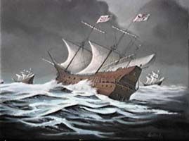
hurricanes in his 35-storm sample which struck Matagorda Bay had rainfall maxima just to the
left of the track. At a first glance, it is unclear why this would happen. However, in a work by
Gilbert and LaSeur prepared in 1956, an explanation becomes apparent. While studying rainfall
patterns associated with Hurricane Florence of 1953, they noted a rainfall minimum east of the
center reminiscent of a dry slot around a mature nontropical low.

   In Texas, this situation would occur when a storm approaches the Lower coast. West winds
through a deep layer of the troposphere wrap dry air around the south side of a modest to large-
sized cyclone initially. This dry air comes from parcels which have decended adiabatically from
the much higher terrain of northeast Mexico. As dry air wraps around the east side of the center,
residual moisture tends to pool on the north and west sides, leading to this uncharacteristic
maximum just to the left of the track.

    There are other impacts on the storm’s structure due to this dry air intrusion. Major hurricanes
such as Allen (1980) and Carla (1961) have weakened due to the decrease in latent heat produced
by less condensation as dry air wraps around the center, effectively shutting down the heat engine
of the tropical cyclone. Gilbert likely did not reintensify to its former category 5 status, partially
due to dry air intrusion (it also upwelled the Gulf waters, cutting off its own fuel source).
Another important effect of dry air intrusion is a higher incidence of severe weather, such as
microbursts, tornadoes, and hail. Celia’s microburst led to 170+ mph winds on the west side of
the storm. Beulah’s 115 tornadoes may well have been due to dry air encircling the cyclone.

Benefits of tropical cyclones. Of the 122 storms chronicled in this survey, 11 are credited with
alleviating drought conditions across the Lone Star State. Without tropical storms and hurricanes
moving into Texas, summer rainfall would be about 10% lower than what currently falls across
eastern Texas. This could be disastrous for cotton, corn, and rice grown statewide, as they are
highly dependent on this added rainfall contribution.

Movement of tropical storms through Texas. Two main tracks exist for tropical cyclones
moving through the state. Most enter from the southeast, and curve north and northeast through
eastern and central portions of Texas. Storms that strike the lower coastline tend to stay on a
more westward track, such as Corpus Christi’s 1919 hurricane, Celia (1970), Allen (1980),
Charley (1998), Bret (1999), and Dolly (2008). This is due to a combination of the circulation
around the perennial Mexican Plateau low/trough, which dominates the low level winds in south
Texas through ten months of the year, including the hurricane season, and the subtropical ridge
which normally becomes established across the Southern Plains during the summer months. The
thermal low in Mexico is present due to air at the same altitude surrounding the Mexican plateau
being cooler, similar to the way (but much smaller in scale) that the low that develops over the
Himalayas of Southeast Asia, which creates the epic monsoons over that portion of the world.

   Early and late in the season, mainly June and October, storms can enter from the south or
southwest, then move north and northeast across the state. Northerly and northeasterly tracks are
due to cold frontal intrusions from the north that cause steering winds to become southerly across

                                                  6
much of the state during those months. This explains why tropical cyclones from the eastern
Pacific wield influence across the Lone Star State, even if their low level circulations have been
destroyed by the Sierra Madre Occidental, the mountain range that crosses Mexico from southeast
to northwest. It also explains why there are very few October landfalls from Gulf cyclones as
very little of the upper Texas coastline lies north or northeast of the Gulf of Mexico.
Long term trends/hurricane cycles. Studies were made back in the 1950's by Dr. W.
Armstrong Price on hurricane incidence along the Texas coast and the sunspot cycle. Regardless
of whether this pattern exists because of sunspots or some other interannual climate cycle, using
data back to 1829 there are periods in the hurricane climatology that have greater activity than
others. These periods were defined as being “hurricane-rich” or “hurricane-poor”. Hurricane-rich
periods last, on average, 11 years with an average of 8 landfalls in their midst. Hurricane-poor
periods last, on average, 14 years and only 2 landfalls usually occur.
We are currently in a hurricane-rich period which began in 2003. This is expected to last
until around 2014, plus or minus a few years. Texas will be extremely prone to hurricane
landfalls during the time frame. Whether or not we should expect as few as two or as many as 8
storms in the next decade, all it takes is one to make life miserable for residents along the coast.
Main sources of information for the history. The list of hurricanes compiled on the following
pages was extracted from various sources. Data since 1851 was referenced against records
maintained by the National Hurricane Center in Sweetwater, Florida. Coordination with Chris
Landsea of the National Hurricane Center has been ongoing since the late 1990’s, as the hurricane
database it undergoing a necessary revision as many old hurricane records have been unearthed
during the past couple decades. Some of the information in this work has been of value during
the hurricane reanalysis, and vice versa. Most data prior to 1851 came from Ivan Ray Tannehill’s
classic book Hurricanes, David Ludlum’s compendium on hurricane history Early American
Hurricanes (1492-1870), local newspapers, publications of the United States Geological Survey
(USGS), and the Army Corp of Engineers. The Western Region Technical Memorandum by
Smith (1986) provided information on many of the east Pacific tropical cyclone impacts on
western Texas.
7Texas Hurricanes - 1527 through 2009 Date Name Landfall Wind Category Dead Min Cent Pres 1527, 11/? - Matagorda Bay - - 200 - 1553, - - Lower TX Coast - - 1,700 - 1554, 4/? - Brownsville - - 50-100 - 1766, 9/04 - Galveston - - - - 1791, - - Lower TX Coast - - - - 1818, 9/12 - Galveston - -
Date           Name          Landfall          Winds   Category   Dead     Min Cent Pres

1885, 9/17        -          Brownsville            -       -           -          -
1886, 6/13    Number 1        Cameron              80       1           -         997
1886, 8/20    Number 5        Indianola           100      2           20         984
1886, 9/22    Number 7      S of Brownsville      100      2             -          -
1886, 10/12   Number 9        Beaumont            100       2        150            -
1887, 9/21    Number 7        Brownsville         100       2          -          980
1888, 6/16    Number 1        Matagorda           100       2           -          -
1891, 7/05    Number 1        Matagorda           100       2           -          -
1895, 8/29    Number 2        Brownsville         100       2          -           -
1897, 9/12    Number 2          Beaumont          100       2        13          1002
1900, 9/08 Galveston Hurricane Galveston          130       3       8,000        931
1902, 6/26    Number 2          Port Lavaca        90      1           0            -
1909, 7/21    Number 3          Velasco          130       3          41         958
1909, 8/27    Number 5        Brownsville        110       2            -          -
1910, 9/14    Number 2         Baffin Bay        100       2            0         965
1912, 10/16   Number 5        Corpus Christi      90       1            0          -
1913, 6/27    Number 1        Corpus Christi      90       1          0            -
1915, 8/17    Number 2          Galveston        140       4        275          945
1916, 8/18    Number 4        Corpus Christi     125       3         20           948
1919, 9/14    Number 2        Corpus Christi     140       4         284          927
1921, 6/22    Number 1          Matagorda        100       2          0          979
1929, 6/28    Number 1          Matagorda         85       1          0          982
1932, 8/13    Number 2          Freeport         140       4          40          941
1933, 8/05    Number 5         Brownsville       100       2           -          975
1933, 9/04    Number 11        Brownsville       125       3          40          949
1934, 7/25    Number 3          Rockport         100       2          19         975
1936, 6/27    Number 3        Port O'Connor       80        1         -           987
1938, 8/15    Number 2     East of Sabine Pass    75        1         -            -
1940, 8/07    Number 2     East of Sabine Pass   100        2         -           972
1941, 9/23    Number 2          Texas City       120        3         4           958
1942, 8/21    Number 1        Galveston Is.        80      1          -           992
1942, 8/30    Number 3          Matagorda        115        3         8          950
1943, 7/27    Number 1          Galveston        100        2        19          969
1945, 8/26    Number 6          Matagorda        110        2         3          967
1947, 8/24    Number 3          Galveston         80       1          1          992
1949, 10/3    Number 10          Freeport        110       2           2          972
1954, 6/26      Alice        S of Brownsville     80        1         17           -
1955, 9/05     Gladys        S of Brownsville     85        1           -          -
1957, 6/27     Audrey           Sabine Pass      145       4           9          945
1959, 7/25      Debra            Galveston        85       1           0          984

                                            9
Date Name Landfall Winds Category Dead Min Cent Pres
1961, 9/11 Carla Port Lavaca 145 4 46 931
1963, 9/17 Cindy High Island 75 1 3 997
1967, 9/20 Beulah Brownsville 135 3 15 931
1970, 8/03 Celia Corpus Christi 125 3 11 945
1971, 9/10 Fern Matagorda 90 1 2 978
1971, 9/16 Edith East of Sabine Pass 100 2 0 977
1980, 8/09 Allen Port Mansfield 115 3 7 945
1983, 8/18 Alicia Galveston 115 3 13 963
1986, 6/26 Bonnie Beaumont 85 1 4 982
1988, 9/17 Gilbert S of Brownsville 135 4 - -
1989, 8/01 Chantal High Island 80 1 2 984
1989, 10/16 Jerry Galveston Island 85 1 3 983
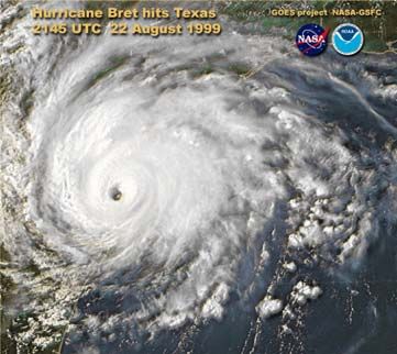
1999, 08/22 Bret Padre Island 115 3 4 951
2003, 07/15 Claudette Port O’Connor 85 1 1 982
2005, 09/24 Rita Sabine Pass 100 2 - 945
2007, 09/13 Humberto High Island 90 1 - 985
2008, 09/13 Ike Galveston Island 110 2 - 951
10Tropical Cyclone Records in Texas
Pressure Deaths
Pressure Date Location Number Dates
27.83" 8/13/1932 East Columbia 8000 9/7-9/1900
27.89" 8/03/1970 Ingleside 1700 4/1554
28.00" 8/18/1916 KingsvilleHurricanes of the Sixteenth Century
November 1527: There is record of a storm sinking the poorly-
anchored boat of Panfilade Narvaez off Galveston Island. Up to 200
lives were taken in this storm. This is the first record known of
storms along the Texas coastline and also one of the most
unusual...it struck during the month of November; only one
hurricane has ever struck during November (1839).
April 1554: Fifteen of the twenty ships of the New Spain Flota,
with around 300 passengers en route from Vera Cruz to Havana, and loaded with silver and gold
along the Lower Texas coast, were demolished during a springtime gale. Three of the heaviest
vessels sunk immediately. The other 17 were either scattered across the Gulf of Mexico,
grounded, or had capsized just off Padre Island near Devil’s Elbow...three of which were the San
Estevan, Santa Maria de Yciar, and Espiritu Santo Andres. Only 300 of the 2000 aboard ship
made it to shore alive. But to the misfortune of the Spaniards, they had horrible relations with the
local tribe of Native Americans, known as the Karankawa. As they struggled to go south into
Mexico, they had to fight them off along the way. Only two of the original 2000 ever lived to tell
the tale of their misfortune. Their story prompted salvage vessels to visit the site on July 22nd
(Chipman).
Early November 1590: A hurricane was encountered in the Gulf of Mexico. Over 1000
lives were lost on ships at sea.
September 12th, 1600: A hurricane offshore New Spain (Mexico) took 60 lives at sea.
Hurricanes of the Seventeenth Century
August 30th, 1615: The ship San Miguel sunk in a storm off the coast of Mexico. No
belongings aboard nor passengers were able to be saved.
October 21st, 1631: A hurricane took over 300 lives at sea while moving through the Gulf
of Mexico.
12Hurricanes of the Eighteenth Century
September 4th, 1766: This hurricane hit modern-day Galveston. A mission, named San
Augustine de Ahumado was located in what is nowadays known as Chambers County. This
mission was destroyed and subsequently abandoned. A seven foot storm surge put the area under
water. A richly-laden treasure fleet of 5 galleons en route from Vera Cruz to Havana was driven
ashore and had to wait many weeks for assistance to come. La Caraqueña wrecked on Galveston
Island while El Nuevo de Constante sank along the western Louisiana coast. Fortunately, much
of the treasure and people aboard were saved.
1791: A hurricane struck the Lower Coast. Padre Island and mainland to the west was put
under water. A head of 50,000 cattle belonging to a Spanish cattle baron were drowned (Ellis).
Hurricanes of the Early Nineteenth Century
September 12-14th, 1818: Among the earliest accounts of a direct hurricane strike on the
Texas coast was this storm which formed near the Cayman Islands, then moved west into the
Bay of Campeche and moved northwest to hit Galvez’s town (Galveston). It was described as a
storm of extraordinary violence. Settlers on the island saw the signs of an approaching storm, but
did not think anything of it since they had been through similar situations before. They anchored
their boats and went to sleep like it was any other night.
They were awakened by the fierce winds, thunder, and waves crashing against their homes.
The entire island was overwhelmed by the storm surge, which flooded the French colony of
Champ d’Asile by four feet. By morning, the city had become a “picture of chaos”. As water
began to invade the hospital, people moved the sick to Maison Rouge (Red House), the residence
of the pirate/privateer Jean LaFitte (Gaillardet).
All but six buildings were reported destroyed on the Island. The pirate Jean LaFitte was
occupying Champ d’Asile at the time and played an intriguing role during the storm, as both a
Spanish spy and a hero. The Spaniards had paid him to keep an eye on this French town, located
in the heart of Spanish territory. His house was used for the sick during the storm, which earned
praise from the community. However, he too suffered losses as most of the ships in his fleet were
destroyed; four in all. Wreckage from some of these ships was dug up by a dredge boat building
portion of the Texas City jetty fifty years later (Block).
War ships from Vera Cruz who encountered this storm were put out of commission for
months. Ships and boats in harbor dragged their anchors and were carried out to sea. Two of the
13boats were later found in “six leagues inland”. Altogether, fourteen ships were claimed by the
hurricane. After the storm, those who had survived fled to New Orleans, bringing an end to the
short history of Champ d’Asile (Gallardet). Estimates of the lives lost during the cyclone
approach 1000 (Cartwright).
September 10th, 1829: Hurricane struck Mouth of Rio Grande. It inundated the Lower coast.
Corpus Christi reported high water. It flooded the Rio Grande as it moved northwest, washing
away the Socorro Mission, originally built south of El Paso in 1691. The building, made of
adobe brick, “melted and sank into the ground” (Ellis). Port Isabel and Brazos Santiago were
destroyed.
August 18th, 1831: A hurricane made landfall near Mouth of Rio Grande. Settlements at the
Mouth of the Rio Grande fell victim.
September 1834: A hurricane struck South Texas. Establishments at the Mouth of the Rio
Grande suffered severely.
August 18th, 1835 (Antigua-Texas Hurricane): This storm
passed directly over the island of Antigua on the 12th. It then
raked the Greater Antilles; passed over Puerto Rico, Hispaniola,
and Cuba before it emerged back into water in the Florida
Straits. The hurricane hit near the Mouth of the Rio Grande on
the 18th (see the above track). In its 28 hour duration, many
houses were blown down at Matamoros. The storm surge
engulfed Padre Island and lowlands along the river.
The hamlet of Villa Hermosa de Santa Anna disappeared during the tempest. Every vessel in
the nearby harbor of Brazos Santiago was either driven out to sea or beached high and dry. One
ship was carried out to sea; when the crew realized the gales and tides were moving them further
and further from land, they jumped into the angry Gulf waters. Galveston Island saw flooding
as well. The schooner Bravo capsized while in Matagorda Bay. The hurricane continued
westward, moving into the mountains of Northern Mexico. At least 14 perished in the storm.
October 2nd-6th, 1837 (Racer’s Storm): The first
recorded storm to rake the entire Texas coast was Racer’s
Storm, named for a British sloop of war which
encountered the system in the extreme northwestern
Caribbean on September 28th. It is remembered as one of
the most destructive storms of the nineteenth century due
to its extreme duration and 2000 mile path of destruction.
14The hurricane made landfall briefly south of Brownsville near Matamoros, lashing the coast
for three days as the storm slowed to a near halt from the 2nd through the 4th of October. All
vessels in Brazos Santiago fell victim to the storm. Paralleling the coast northeast, the storm took
another ship victim offshore Matagorda Bay. Settlements along the bay all suffered heavy losses.
All vessels at Velasco were driven ashore. Velasco and Brazos river shipping suffered
immensely.
Then it was Galveston’s turn. The storm there lasted from the 3rd through the 5th. A
storm surge 6 to 7 feet higher than the spring tide inundated the coast. The scene on the Island
was one of utter desolation. The new Tremont hotel was blown over. Nearly all the homes on the
island were blown down; all provisions were lost. Two churches also met their fate. Water levels
at Houston rose 4 feet. The whole character of the harbor entrance shifted during the hurricane.
Ships were shoved as far as 3 miles inland. A three masted bark was driven high aground
across the Golden Triangle. Two Texas Naval schooners were dashed to pieces on Galveston
Island. The storm passed offshore of Sabine Pass on the 6th, then into Louisiana. At least two
people perished. See Louisiana Hurricane History for more on this large and powerful system.
1838: Hurricane made landfall along Lower Texas coast; caused high tides. Settlements
at the Mouth of the Rio Grande again suffered as the hands of a tropical cyclone.
November 5th, 1839: Hurricane struck Galveston unusually late in the year.
1840: Hurricane destroyed villages at Mouth of Rio Grande. Flooding was also noted.
September 17-18th, 1842: A strong tropical storm hit Galveston. The city was on the west
side, as waters invaded from the Bay to their north. About 4 feet of water covered the island,
destroying smaller buildings and houses. Forty cattle were crushed under a house that was
leveled during the storm. Damage totaled $10,000.
October 5th, 1842: A storm brushed by Galveston, flooding the town. The schooner Dream
foundered between Galveston and New Orleans. All aboard the ill-fated vessel were rescued
(Ellis).
The village of Brazos Santiago had been established by the Mexican government as a
customs point for many years prior. An army garrison had been established there after Texas
gained independence. The village site was just a few feet above sea level on Brazos Island and
was extremely vulnerable to coastal flooding.
August 6th, 1844: This hurricane produced the first records of large loss of life along the
lower Texas coast on the 6th. Residents on Padre Island fled to Matamoros for shelter. The
151844 storm completely destroyed the settlement of Brazos Santiago with a loss of 70 lives after
the waters eroded a pass clear through the old settlement. The only survivor was reported to be
the captain of the pilot boat who remained offshore. In Corpus Christi, high winds and tides
capsized a pirate raft, loaded with their treasures. The Mexican Customs Office was moved to the
mainland due to this storm.
October 17th, 1848: A hurricane struck the Lower Coast. Brazos Santiago Island was under
two feet of water. Several vessels were lost near Point Isabel. Tides were reported as high at
Corpus Christi (Ellis). This storm relieved “spotty drought conditions” along the Middle Texas
coast (Malsch).
July 1st, 1850: A “severe squall” came across Matagorda Bay at Indianola, causing damage.
The force of the gale tore the Palmetto from her anchored position, and drove here aground. The
lighter Jerry Smith suffered extensive damage to its upper works (Malsch).
Hurricanes of the Late Nineteenth Century
June 25th, 1851: A short yet severe storm passed over Matagorda Bay and was described
as the most disastrous experienced up until that time. Salt water contaminated the water supply
at Saluria, on Matagorda Island. Widespread wind damage was reported at Saluria and Port
Lavaca. Every wharf at Port Lavaca was destroyed by the wind. The brunt of the cyclone struck
Indianola at 2 p.m., increasing throughout the night. The Government Wharf was battered by the
waves. Buildings suffered damage on the Bay, but the storm surge did not cover the nearby spit,
creating a false sense of security.
The schooner William and Mary was cast onto the beach, left “high and dry” (Malsch). The
William Penn was torn from her mooring, and sank in five feet of water. The sloop Commercial
was dashed to pieces. In the Gulf, the steamship Maria Birt was lost, but all aboard survived.
Victoria citizens were “greatly annoyed” that all the mail for Victoria, San Antonio, and West
Texas was swept into Matagorda Bay.
September 17-19th, 1854: A hurricane hit Matagorda/Galveston. The main impact of the
storm was around Matagorda and Lavaca Bays. Every vessel and wharf on Matagorda Bay was
destroyed. Wharves at Old Town also met an untimely fate. The storm surge went through with
such force that the channel was straightened and deepened by 2 feet. The town of Matagorda was
leveled. Many buildings fell victim, including the Methodist and Episcopal churches. The storm
led to a yellow fever outbreak, which would spread from Indianola to other surrounding
communities over the next several weeks. Saluria suffered $20,000 in damage.
16Merchants on the Strand and Market Streets in Galveston suffered much water damage from
the eight foot storm surge. Brazoria also encountered strong winds from the storm. Crops of
sugar cane and cotton were ruined. Many small vessels perished. The steamer Kate Ward and
her crew were a total loss. The little steamer Nick Hill went down off Dollar Point in Galveston
Bay.
The storm then moved northwest over Columbus, and in its dissipating stage became a
widespread rainstorm over the western and central Gulf Coast causing 5.55" of rain in Baton
Rouge between the 17th and the 21st with rain falling as far east as Pensacola. Four lives were
lost in Matagorda...while many more were claimed by yellow fever.
1857: This storm hit Port Isabel. It swept away several hundred homes and damaged the
towns of Brazos Santiago, Clarksville, and Bagdad, all near the Mouth of the Rio Grande.
September 13th, 1865: A hurricane hit southwestern Louisiana. Orange saw the greatest
damage. Four out of 200 homes were left standing. Twenty five people were killed by falling
debris and flying timbers. At Bagdad, near the Mouth of the Rio Grande, backwater flooding
and swells from the storm inundated the town.
Nineteen of 20 ships capsized in the Sabine River. The schooner Lone Star was wrecked
near Redfish Bar on Galveston Bay, in nine feet of water. By the time the steamer Nashua was
sent in search of survivors, the Lone Star had gone to pieces. Survivors were scattered widely
across the area. One of the sloops in search of the Lone Star and her former crew almost
foundered itself in the high winds. All cargo of the Lone Star was lost.
July 15th, 1866: A strong tropical storm struck Port O’Connor. It was considered severe,
but no lives or buildings were lost. Affects were noted at Galveston and Port Isabel.
During the Civil War, most of the Confederacy’s cotton was shipped out of South Texas and
Mexico. Two communities two miles inland of the mouth of the Rio Grande boomed because
of this commerce, particularly the town of Bagdad on the Mexican side of the river, which grew
to a population of several thousand. Clarksville, on the U.S. side, was much smaller. Bagdad
had a reputation for lusty living and was compared to New Orleans in its style.
October 2nd-3rd, 1867: A hurricane moved northeast, offshore the Texas coast. This storm
struck the mouth of the Rio Grande with great fury and devastated both cities. Brazos Santiago
was again devastated, with most of the buildings leveled. Clarksville was soon abandoned, and a
later storm in 1874 finished off Bagdad. A few glass and metal relics buried in the sand are all
that remain of both towns. The population at their peaks totaled over 20,000. Brownsville, Port
Isabel, and Matamoros were severely crippled. The military railroad ceased to exist. Four
steamboats were sunk.
17Galveston was inundated by the storm surge on the 3rd , measured as one foot higher than
the 1854 storm. All wharves were “nearly demolished”. At the time, it was considered the
most severe and disastrous storm in the city’s history. Mud slides buried Matamoros.
This storm followed a path similar to the Racer’s Storm, and produced great damage along
the entire coast. It is regarded as the first “million dollar” hurricane in Texas, most inflicted
upon Galveston. In an editorial after the storm in the Ranchero, a newspaper that evolved into
the present day Brownsville Herald, the editor asked the question, “What would happen if a
similar storm struck Galveston directly as it had the lower coast?”
August 16th, 1869: A “short but severe” hurricane struck the lower Texas coast, doing the
most damage at Refugio and Indianola. Several houses were blown off their foundations in
Rockport, St. Mary’s, and Saluria. “Tornadic winds” demolished the Episcopal church of
Ascension in Indianola. Several buildings were unroofed. All orange and apple orchards in
Sabine Pass were destroyed in the storm. Limited damage was seen at Rockport and Corpus
Christi.
Along the Indianola waterfront, boats were beached and capsized, while wharves and
warehouses were battered by wave action. The storm surge invaded Indianola, leaving water in
the streets that was one foot deep. After the storm, Indianola congratulated itself about “the
obvious security of our little city” (Malsch). Only six more years would pass before this claim
became unjustified.
June 2nd-5th, 1871: Hurricane made landfall along the Texas coast. Lowest pressure at
Galveston was 29.51", where 15.57" of rain fell during the storm...four inches fell in only 15
minutes! Port Aransas recorded an “extraordinary high tide” and a fresh gale. Minor wind
damage was experienced at Indianola, where Gulf waters flooded lower portions of town.
The Virginia Dare grounded on the outer sandbar off the beach of Galveston. Its crew was
rescued. The steamship Alabama was thrown ashore, her cargo of cattle swam ashore. A party of
four men drowned while attempting to pass through the breakers. Several small beach houses at
Galveston were washed away. At Houston, several houses were blown down and trees were
uprooted.
June 9th, 1871: A hurricane moved through East Texas. In Galveston, it wrecked many
ships and leveled the St. Patrick church. Several houses were destroyed and the east end of the
Island went underwater. Minor coastal flooding was seen at Indianola. Winds blew off the roof
of the Catholic church in Refugio, killing one person.
September 30th-October 3rd, 1871: The third hurricane to affect Texas in 1871 moved just
offshore the length of the coast. On Mustang Island, it was the strongest gale in 16 years. On the
30th, strong east winds at Indianola increased tides “at an alarming rate”...lower portions of town
quickly flooded. As winds increased, most of Indianola flooded. Damage was widespread near
18Powder Horn Bayou. Waters receded on the 2nd, as northerly winds swept flood waters back into
the Gulf of Mexico. Tides at Indianola were the highest since 1844. A weather observation site
was established at the city soon afterward by the U.S. Signal Service, in May 1872.
Torrential rains wreaked havoc at Lavaca. High tides flooded warehouses under the bluff. The
jail at Lavaca was washed away. Serious damage was done to the railroad property near
Chocolate Bayou. A ship named the S.S. Hall sank during the storm; all hands were lost. Many
people perished, at least three in Galveston.
Water became knee deep on the Strand in Galveston. The steamer Beardstown was blown
onto the wreck of the Mollie Hambleton and received significant damage. The steamer
Matthews sunk during the storm. The steamer Twelfth Era, initially anchored off the point of
Pelican Island, was totally wrecked. A 25 ton schooner washed upon the railroad tracks near
Galveston. The schooner Sarah Cole was also blown ashore.
July 2nd-4th, 1874: Hurricane made landfall near Indianola. Damage was noted as far away
as Corpus Christi, where damage to the waterfront and extensive erosion were seen.
September 4-6th, 1874: A tropical cyclone originating in the Bay of Campeche made
landfall just south of the Rio Grande. It was the worst storm at Corpus Christi since the city was
named Kinney’s Rancho. A gale accompanied by rain increased in intensity towards the evening
of the 4th. Bathhouses and wharves were beaten by the waves back into lumber. Waves
“mountainous high” rolled onshore. Heavy winds and rains continued until 3 PM on the 5th,
when the eye passed overhead. Soon after, winds became southerly and were at their worst.
Schooners were shoved inland, ramming houses and trees on their way. Water Street was no
longer in existence. Half the chickens in the city met an untimely fate (Ellis). The Brazos
Santiago lighthouse, already rotting, was completely wrecked, and the light keeper’s wife lost
her life in the storm (Cipra).
Velasco, one of the oldest towns in Texas, was located at the Mouth of the Brazos River.
Soon after its founding in 1821, population swelled. By the time of the Texas Revolution in
1835, over 25,000 people resided in the town. It briefly became capital of the Republic of Texas
in 1836.
First Indianola Hurricane - September 1875
September 14-17th, 1875: The first indication of a new storm in the Atlantic came from a ship
southwest of the Cape Verde Islands on the 1st. Near 12N 27W, the Tautallon Castle encountered
a “heavy gale accompanied by all the peculiarities of a hurricane” (Malsch). A vessel in the
Atlantic on the 5th also encountered the hurricane, noting a “terrific sea” and a pressure of 29
inches. Other ships encountered the cyclone around the same time, but did not live to tell their
19tale.
It moved west into the Caribbean and grazed the coast of
Haiti. On the 12th, the isle of Nauassa, off Haiti’s Cape
Carcasse, reported seas breaking over cliffs between 45 and
75 feet above sea level, large trees uprooted, and many
buildings destroyed. It then passed over Cuba on its way to
the Gulf of Mexico. As it passed south of the Florida Keys,
many vessels were driven ashore, including the steamer City
of Waco. By the 14th, the Chief Signal Officer in
Washington, D.C. believed the hurricane would go to
Mobile, and warnings were issued for the Alabama coast.
At the same time, a shield of cirrostratus clouds led to the appearance of a solar halo along
the Texas coast. Around Matagorda Bay, winds gusted to 40 mph that day, backing to a more
northerly direction that night. Waters on the Bay began to rise on the 15th, as squall moved
inland. By the morning of the 16th, increasing tides had broken the high tide mark set in 1871.
It made landfall at San Jose Island, before crossing Copana Bay and moving inland (track on
the right). Sand dunes were leveled on Matagorda Island. Several chickens, roosting in trees
during the storm, perished on Mustang Island. Old Velasco was leveled in the storm. It wasn’t
until 1888 when it was rebuilt four miles upstream of its previous location. The East and West
Shoal lighthouses, at Pass Cavallo, were swept out to sea, along with their 4 light keepers. At
Upper Saluria, 90% of the residents drowned.
Indianola was adversely affected by the tempest. By noon on the 16th, wharves were being
carried away by the invading storm surge. By 6 p.m., the Signal Office collapsed. The eye
passed overhead Indianola just after midnight on the 17th. Tides reached fifteen feet above the
normal high tide. Three-fourths of the town was swept away...270 lives were lost. The highest
wind measured was 88 mph, before the anemometer blew away. Later gusts were estimated
between 145 and 150 mph. Winds were estimated to be sustained near 100 mph at the storm’s
peak. Winds slowly abated during the evening of the 17th. Twelve new bayous were carved out
by the storm, as the waters receded quickly back into the Gulf. Boats were carried 9 miles
inland. Looters caught pillaging the dead were killed, 15 in all. After the storm, Indianolans
considered a move further inland; however, political ambitions interfered, and the matter was
forgotten about.
In Galveston, northeast winds began on the night of the 14th. The wind was “higher and
harder” than in 1867. Winds reached gale force by 11 a.m. on the 15th. Buildings began to be
crushed by the increasing tides at 2 a.m. on the 16th. By the 17th, the tide had risen to 6.48 ft
above mean low water...tides up to ten feet were seen around Galveston Island. Winds were
highest from the northwest, 60 mph, after the storm passed by...estimates of 110 mph were made
by several on the scene. The pressure fell to 29.05". Two channels were cut across the east end
20of the Island, with one prolonging the Bolivar Channel. Several houses were swept away from
the east end of the Island. The Santa Fe railroad bridge was obliterated.
At Harrisburg and Houston there was a “terrific gale”. The water was driven up from the
bay higher than known before. In Austin county, the storm raged for 48 hours. Cotton plants
were stripped and trees fell in great numbers. The steamship Australian, loading with cotton,
went ashore near St. Bernard. The bark Edward McDowell went aground in eight feet of water.
Boats were pushed 5 miles inland. Out in the Gulf of Mexico, the steamer Paisana, its hull
loaded with $200,000 in canvas bags, was lost of its way from Brazos Santiago to Galveston.
After this hurricane, on October 1st, cautionary signals for hurricanes consisting of a red flag ten
by eight feet, inset with a black rectangle, went into use. At night, these flags were to be
illuminated at night, so those on land and at sea knew when to expect the next storm.
September 15-17th, 1877: Hurricane affected the entire Texas coast. In Galveston, winds
were noted out of the east on the night of the 15th. By the 17th, tides increased to 5.2 feet above
mean low water. Winds increased to 60 mph at that time. High tides, though, were the main
villain. Matagorda Bay saw light winds and squally weather. A fresh gale at Mustang Island
destroyed their wharf.
August 22nd-23rd, 1879: The Golden Triangle of southeast Texas coast hit by a hurricane.
At Orange, winds rapidly increased until 7 p.m., when the eye passed overhead. Winds then
shifted to the south. All sawmills in the region were damaged. Railroad cars were blown off
their tracks. Trees were uprooted as well. The steamboat Flora sank, with other steamers
reported as seriously damaged. Mustang Island reported high winds and tides during the storm.
August 12th, 1880: On the 3rd, a tempest loomed east of the Lesser Antilles, moving on a
westerly course. It moved through the northern Caribbean to strike near Cancun and the
northeast Yucatan peninsula on the 9th. After moving west northwest through the Gulf, the
hurricane made landfall just south of the Rio Grande on the 12th, moving northwest to dissipate
in Central Texas on the 14th.
Matamoros was left in shambles. Corpus Christi saw “a furious gale” and the pressure fell
to 29.52". Structures on Padre Island were leveled. A number of “fine pigs” were lost during
the storm. An eight foot storm surge flooded the area under the bluff. At Brownsville, it was
one of the worst hurricanes in their history. It took 45 minutes for the eye to pass overhead. The
city reported 7.82" on that day...which set a 24 hour rainfall record for the month of August. At
least five people died.
October 12th, 1880: A storm passed over Cuba from the 3rd through the 9th, moving west
into the Gulf of Mexico. It struck Brownsville on the 12th. The city was nearly destroyed and
many lives were lost. Telegraph wires were down from Indianola southward.
August 12-14th, 1881: A storm in the Central Gulf of Mexico moved west northwest into
21Corpus Christi. At Murdock’s Landing, signals were blown down and a flat boat was lost. High
tides and squalls were seen at Indianola.
September 14th, 1882: A strong tropical storm hit the Mouth of the Sabine River. A “terrific
wind and rain storm” caused damage to homes in Sabine Pass. The Lake Charles Echo reported
it as a “hurricane” that destroyed a house and injured its occupant. Streets in town were covered
by 3 feet of water. Fences were blown over a mile from their previous location.
September 18-20th, 1885: This hurricane hit Brownsville before recurving northeast into
Louisiana and moving through the southeastern United States. Indianola saw winds of 48 mph.
By 9 a.m. on the 19th, Indianola was inundated. In Galveston, storm warnings were hoisted but
the flag was blown away. The city saw more than 6" of rain, along with coastal flooding. High
seas caused the coal barge Orient to drift free of its tugboat and wedge into the Gulf bottom. Four
on the barge died.
June 14th, 1886 - Calcasieu Pass: Two tropical cyclones
made landfall that season near the Sabine River. The first, a
strong tropical storm, caused inundation to extend several
miles inland, worst at 10 am. Galveston had barely
recovered from a fire 7 months before. It was considered
their worst since the Hurricane of 1875. Winds began
briskly out of the northeast early that Monday morning,
shifting to the south at speeds greater than 50 mph. The
pressure fell to 29.43" (track on the left). Galveston Island
was submerged. Damage was scattered in nature. Cottages
were swept away, railroad tracks were undermined, and a
large number of sloops and yachts fell victim. The tug Idler
was wrecked during the storm.
Winds were considered worse at Sabine Pass. Telegraph poles were thrown several hundred
yards. Seven feet of water overwhelmed the town. Five to six miles of railroad track was
washed away. All the wharves disappeared. Several buildings were leveled. One man helped
others escape the area, despite water up to his neck. One life was lost, a ferry man, during the
storm.
Last Indianola Hurricane - The Loss of One of Texas’ Major Ports
The city of Indianola was founded on the west shore of Matagorda Bay in 1844. Immigrants
from Germany, Switzerland, and France led to its establishment. After going through several
rough years as an immigrant camp, homes were built. The city’s burgeoning trade with the West
led to the town’s prosperity...even though the hurricane of 1875 dampened some of those hopes.
22The summer of 1886 was a hot and dry one, with below normal rainfall for 14 months. When
cloudiness rolled in on the 18th, people were eager for rain. However, a strong east wind set in,
causing blowing sand and dust to envelop the region.
August 18-20th, 1886: Indianola suffered its fatal calamity from a hurricane, only 11 years
after the last major storm swept through the area. Winds increased throughout the night of the
19th. Matagorda Bay began to invade the city by daylight on the 20th. The wind increased to 72
mph before the Signal Office building collapsed; the observer was killed by a falling timber
during his attempt at escape. A lamp in the office burned down the building, along with more
than a block of neighboring buildings on both sides of the street, despite the heavy rain. Although
the storm was of shorter duration than the one in 1875, winds were considered higher. A storm
surge of 15 feet inundated the region, covering the base of the Matagorda Island lighthouse with
four feet of water. A large schooner was carried five miles inland (Malsch).
The town was a “universal wreck;” not a house that was left standing was safe to dwell in.
Buildings that survived the 1875 storm were destroyed. Houses, carriages, personal property, and
dead animals were strewn along the coastal plain. About two and a half miles of railroad track
was washed away, not to be rebuilt. The village of Quintana, formerly the sister city of Velasco
and also located at the mouth of the Brazos River, was almost entirely swept away. Despite
Texas legend and according to the Houston Post, Indianola was not totally abandoned after this
storm, as the next storm in this history shows. However, most people in town left for the greener
pastures of Victoria and San Antonio.
In Galveston, winds were “furiously from the southeast” at 10 am on the 19th, causing area
sand to reduce visibility to near zero (Houston Post, 8/21/1886). Winds increased until 5 p.m.,
and remained high until noon on the 20th; 50 mph at 10 a.m.. Houses careened in the storm surge
after midnight. Wires and trees were downed, bridges were submerged, and communication was
cut off. In Houston, winds increased to gale force at 930 am on the 19th. The height of the
bayou rose 5-6 feet during the storm.
In Victoria, the worst of the storm occurred at 5 a.m. on the 20th. An eastbound train was
blown over. Two churches were damaged beyond repair; six were heavily damaged. Very few
buildings escaped the hurricane unharmed. At Rockport, 6 or 7 houses were leveled along with
Temperance Hall and Fulton’s cistern factory. Cuero reported a considerable loss. Several
houses were destroyed at Edna. Corpus Christi saw winds of 75 mph out of the northwest, drying
up the Bay for two hours, leaving boats “high and dry”.
It was considered the worst storm ever in much of interior Southern Texas. Goliad had
numerous homes unroofed. La Grange had considerable damage to fruit and cotton. Weimar
saw two churches leveled and great destruction to corn and cotton. Throughout Bexar county,
cotton was in ruin; its Methodist church was also destroyed. In South Central Texas, damage
was considerable. The storm continued northwest and caused a gale to blow at 10 a.m. on the
20th...with the center of the system over San Antonio at 2:40 p.m.. Winds remained near 80 mph
23and the lowest pressure observed was 29.03." Damage at San Antonio alone totaled $250,000.
At New Braunfels, the International freight depot was destroyed.
One of the most positive aspects of the tempest was the rain it brought. A serious drought
had developed across the region. In Galveston, water was being sold for 10¢ a bucket, twice
the going rate for beer. It was so bad at Corpus Christi that residents had to give water to the
poor, lest they die of dehydration. The drought was considered broken at Stephenville. Heavy
rains led to flooding of streams in central Texas.
A number of ships met their fate off Galveston. A large schooner went on a rampage and
broke through the Santa Fe bridge, pushing the train into the angry seas. The schooner Livonia
capsized just off the sand bar in 6 fathoms of water. The J.W. Perry foundered fifteen miles
offshore. Around 30 people died and total damages were estimated near $2 million.
Preceding this disaster, Indianola had been Texas’ leading port of call. Due to the major
destruction to the infrastructure, Galveston reaped the benefits, thereby becoming Indianola’s
successor. The winds of change would blow again around the turn of the century.
September 22nd-23rd, 1886: The battered Texas coast struck again, this time at Brownsville.
It was a fairly large sized storm, accompanied by a good amount of rain, nearly 26 inches (25.98")
fell at Brownsville...the 11.91" that fell on the 22nd set a 24 hour rainfall record for the month of
September. Very heavy rain fell west of Victoria.
Indianola was again in peril. Before winds increased fully, reaching 60 mph by 6 p.m., waters
flooded the area from Matagorda Bay for the second time in five weeks, waist deep by noon.
Almost all persons from there evacuated, many in boats, except for one family. Due to the mass
exodus from the area, the post office was closed there in October 1887, officially signaling the
end of Indianola.
The cast-iron Matagorda lighthouse was battered by the powerful storm. The tower shook
so hard that part of the lens was smashed onto the floor of the lantern. Everything in its vicinity,
outside of the lighthouse and the keeper’s quarters, was swept away by the storm surge (Roberts).
Victoria also saw gale force winds that evening. The railroad track between Edna and Wharton
was underwater for a twenty-mile length, due to excessive rains. After the hurricanes of 1886, the
region around Matagorda Bay sank into an economic depression that would last more than fifty
years (Malsch).
Near Abbott, a tornado touched down 3 miles west of town. People watched in awe as the
twister unroofed a barn and plowed harmlessly through a corn field before lifting back into the
clouds. Its width was only a couple hundred yards. In Galveston, winds increased out of the
east to 25 mph at 7 p.m.. The railroad track was buried in sand. Only slight damage occurred.
October 12-13th, 1886: This second hurricane to affect the Upper Texas coast proved much
24more devastating. At Galveston, winds reached 50 mph,
causing the Gulf to invade the island. Little, if any, damage
was seen there. At Orange, trees were downed and the
Catholic Church was leveled.
Sabine Pass, at the time a small city of several hundred,
was “virtually swept out of existence.” The full fury raged
during the afternoon of the 12th. The winds began out of
the east and became southerly with time. By 5 p.m., winds
reached 100 mph. Waves 20 feet high rolled in from the
Gulf. Nearly every house in the area was removed from its foundation, including a hotel with 15-
20 people inside, which was washed out to sea. A track of the cyclone is on the right.
Ten to eleven miles of railroad track was damaged. Furniture was strewn along the coast.
One hundred two people perished in that city alone. Thousands of dead cattle, hogs, horses, and
fowl laid everywhere after the storm. The schooner Henrietta went ashore and was considered a
total loss. The schooner Silas was shoved across the railroad track, out onto the prairie.
Johnson’s Bayou and Sabine Pass were overwashed by the storm surge of up to 7 feet, which
extended 20 miles inland. A woman crossed Sabine Lake on a feather mattress during and
after the storm. She was without food for 40 hours before making her final landfall.
September 21st, 1887: This storm eyed the battered Middle Coast before turning west.
Brownsville saw its second hurricane in as many years. Winds were observed out of the north
as high as 78 mph. The pressure fell to 28.93" and stayed below 29 inches for several hours.
Subsequent flooding from the 36 hours of rain invaded low areas, damaging crops. Fourteen
sailors were lost at sea. In Galveston, three days of wind were seen as fringe effects from the
storm; as high as 36 mph between 8 and 9 p.m. at the observation site and 50 mph along the
immediate coast. Water only invaded low areas on the island. Corpus Christi fared well, only
experiencing a northeast gale, but no damage.
June 16th-17th, 1888: The Upper Texas coast is struck by a hurricane. Corpus Christi had the
pressure fall to 28.72" and three inches of rain.
July 5th, 1888: A second hurricane hits Galveston, making 8 hurricane landfalls in 3 seasons
for the battered Texas coast. Corpus Christi saw two inches of rain from the system.
July 5th, 1891: A hurricane formed in Bay of Campeche on the 3rd and made landfall near
Sabine Pass on the 5th. It affected the entire coast; part of Galveston was inundated.
August 29th, 1895: This hurricane moved through Caribbean and Gulf of Mexico before
making landfall 80 miles south of Rio Grande on the 29th. The town of Abasola in Mexico was
totally washed away. The nearby town of Rodriguez no longer had a house standing. Corpus
25Christi saw 75 mph winds; trees and houses were blown away. Rockport experienced a severe
gale for 36 hours, building high tides not seen since 1883. Velasco had winds of 40-50 mph,
heavy rain, and a 3-4 foot storm surge. The tide was high enough at Galveston to flood several
blocks of the city.
September 12-13th, 1897: A minimal hurricane
moved into extreme southeast Texas from Louisiana
(track on the right). The pressure at Galveston fell to
29.58". At New Sabine Pass, water was six feet deep;
only 2 buildings were left intact. Sabine Pass had 3 ½
feet of water in its streets. Port Arthur was nearly
wiped out. Winds began blowing a gale there at 10 am.
By 2 p.m., Sabine Lake had become a “seething, rolling body of water” (Houston Post). By 6
p.m., winds reached hurricane force. The air was filled with flying boards and timber.
Conditions improved after 9 p.m.. Hardly a building escaped unharmed. The newly completed
pier was washed away, as well as miles of railroad track in Jefferson County.
In Winnie, every house in town saw damage. Every rice farm in Taylor’s Bayou was leveled.
Winnie reported a $12,000 loss to its rice crop. The storm raged until midnight in these locations.
Burnet set a 24 hour rainfall record for September when 3.17" of rain fell.
In Beaumont, winds were high between 6 and 11 p.m.. The Baptist Church in Beaumont was
demolished. Telegraph and telephone lines were downed. It was considered the worst storm at
Orange since 1875. Roofs were blown off, trees uprooted, and windows were smashed. Homes
in Liberty County suffered as well. Cotton was in jeopardy across much of east Texas. In
Galveston, sections of roof were peeled off Olympia.; its third floor caving in. Smaller ships in
the Bay perished in the high seas. The steamer Umberland was delayed getting into port at
Corpus Christi due to high seas.
A frightening Union Pacific train ride occurred during the storm between Beaumont and
Devers, heading westward towards Houston. Its headlight was torn away, the smoker’s roof
was sheared away by the wind, and the ladies coach was twisted. The train only ended up being
an hour and 20 minutes late. The bark Ceries and the tug boats Fannie, Florence, Guillotte, and
John P. Smith met their fate. Looters invaded the area, but quickly left when threatened with
hanging. Sea gulls were blown inland as far as Bryan. Six died at Port Arthur, three offshore,
four in Sabine Pass, and sixteen others perishing at
Beaumont; damage totaled $150,000.
Twenty-four hour rainfall records
June 27-30th, 1899: A tropical disturbance moved off set for June during this storm
the Gulf of Mexico on the 27th. What the system did to
Texas was very disturbing indeed. Torrential rains fell Brenham 29th 8.76"
over the Brazos River basin from Granbury and Waco Hewitt 29th 8.10"
south to the coast (rainfall records set during storm on the Danevang 28th 8.00"
th
Temple 27 6.65"
th
26 Panter 28 3.75"
th
Lampasas 28 3.45"previous page). Between ten and twenty inches fell between Temple and Palestine. At Hearne, in
Robertson County, the rain gage overflowed at 24"; the observer estimated that over 30" fell. The
flood on the Brazos was the worst since 1852. At Waco, it compared to the Flood of 1885. Farm
equipment and tenant houses were washed away. The town of Quintana, at the mouth of the
Brazos river, was nearly swept out to sea (Guthrie). Ten million dollars in damage occurred.
Twenty four people perished in Robertson County alone.
The Great Galveston Hurricane -
The Last and Worst Hurricane of the Nineteenth Century
The question from the Racer’s Storm was tragically prophetic as the Great Galveston
Hurricane showed on September 7-9th, 1900. It towers alone as the worst natural disaster in
the United States in terms of lives lost; the most frequently used estimate of the death toll is
8,000. The potential of this disaster had been shown in the destructions of Santiago in 1844,
Clarksville/Baghdad in 1867, and Indianola in 1875 and 1886. At the time, the population
of Galveston was near 30,000. Most of its structures were wood frame built just above ground
level and supported by pilings.
A new innovation helped relay details about what the
storm did in the Caribbean Islands; it was known as the
wireless telegraph. Word had been received of a hurricane
which had struck Trinidad and destroyed almost all the
structures on that island. Word of the storm’s passing over
Cuba and moving northwest into the Gulf in the direction of
Texas had been relayed to the local weather office in
Galveston Island (track on the right). Sailors began to arrive
in the port telling of nasty weather offshore.
On the 6th, a hurricane watch was posted along the Gulf
Coast, westward to New Orleans. Winds began to increase as
high, fish-scale shaped clouds (altocumulus) began to move
inland By the next day, it was extended west to include Texas. Driving rain began at 4 a.m..
Large waves began to pound the shores of Galveston Island. The pressure began to fall rapidly at
the Weather Bureau station. This caused them to hoist a Hurricane Flag - their version of a
hurricane warning in those days. This action caused about 20,000 people to evacuate, a move that
saved many lives.
Yet a number of people ignored the warning. Gentry from Houston rode out to the island via
train to witness the huge waves first hand. Through the morning of the 8th, greater and greater
27You can also read