HURRICANE DORIAN BRIEFING - 6:30 AM EDT Thursday, September 5 2019 Prepared by: WFO Wilmington, NC
←
→
Page content transcription
If your browser does not render page correctly, please read the page content below
HURRICANE DORIAN
                             BRIEFING
                                       6:30 AM EDT
                                Thursday, September 5 2019
                              Prepared by: WFO Wilmington, NC
What has changed: LIFE THREATENING FLASH FLOODING LIKELY, rainfall amounts increased and flooding risk increased to
Extreme, TORNADO WATCH now in effect
Next Briefing: Last scheduled, will provide updates as conditions warrant
Disclaimer: The information contained within is time-sensitive. Do not use after 4:00 PM EDT Thursday.

 NWSWilmingtonNC                                                                                          www.weather.gov/ilm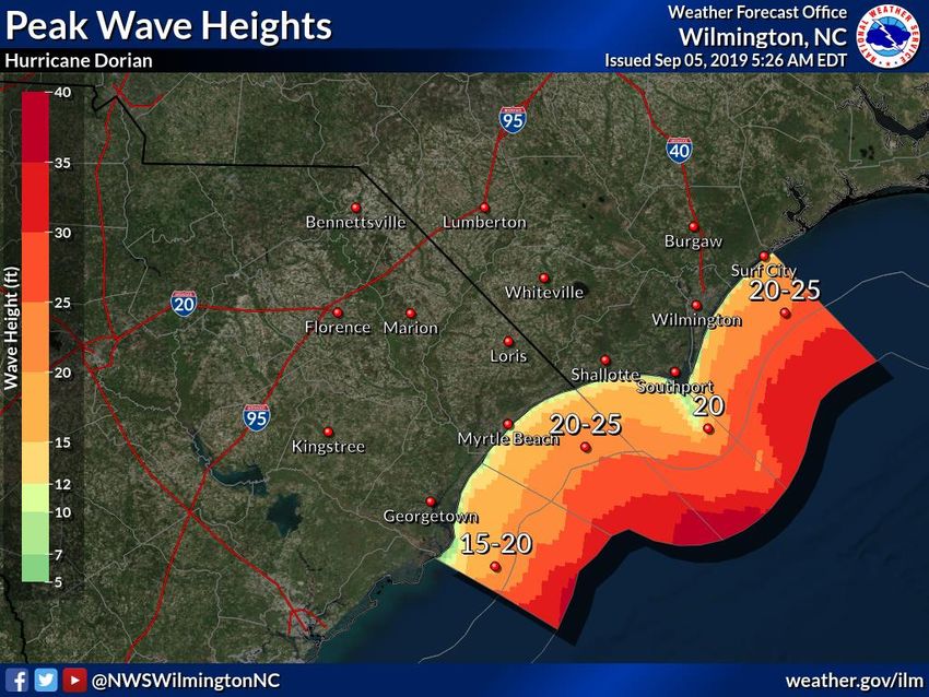
Situation Overview                                        Wilmington, NC
      Hurricane Dorian                                   WEATHER FORECAST OFFICE

• Major impacts including coastal flooding from storm
  surge, power outages, some structural damage, and
  flash-flooding is expected, especially closer to the
  coast. Conditions will deteriorate from south to
  north today through this evening

• FLASH FLOOD WATCH, HURRICANE WARNING,
  and STORM SURGE WARNING are in effect for
  Georgetown, Horry, Brunswick, New Hanover, and
  Pender Counties.

• FLASH FLOOD WATCH and TROPICAL STORM
  WARNING are effect for Bladen, Columbus,
  Robeson, Dillon, Marion, Marlboro, Darlington,
  Florence and Williamsburg Counties

 9/5/2019 6:35 AM                                                    www.weather.gov/ilm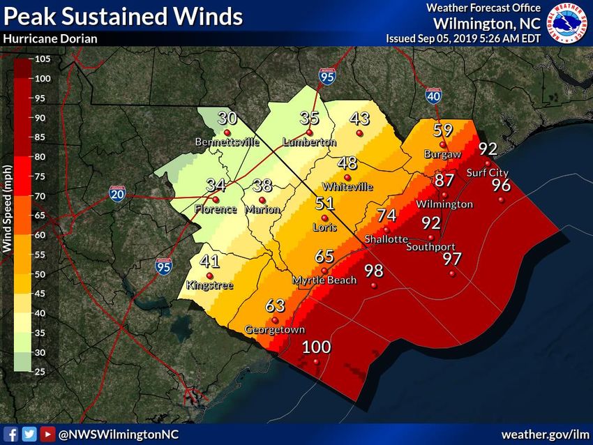
Situation Overview                                                                                                         Wilmington, NC
     Hurricane Dorian                                                                                                  WEATHER FORECAST OFFICE

      Hazard                                     Impacts                                             Location                         Timing
                    Tropical storm force winds developing. Hurricane force winds expected        Highest potential and
                                                                                                                              TS Force winds developing
  Wind               along the coast and adjacent waters. Power outages, some structural       strongest winds expected
                                                                                                                                    this morning
                       and tree damage are likely in the area with the highest winds.               along the coast

                                                                                                                                Surge is expected to be
                    Impacts from Dorian’s storm surge are expected. Inundation, damage         Coastal areas of southeast
Storm Surge/                                                                                                                   significant, especially with
                      to coastal structures, major beach erosion and ocean over-wash              North Carolina and
Inundation                                                                                                                    high tide this afternoon and
                                                 expected.                                     northeast South Carolina.
                                                                                                                                     possibly tonight

                      10 to 15 inches of rain (lesser amounts farther inland) with locally     The highest amounts are
                                                                                                                              Rainfall increasing, with the
                   higher amounts up possible along coastal areas. Flash-flooding, flooding      expected east of I-95,
Flooding Rain      of roads, small creeks/streams and poor drainage areas expected where        especially along coastal
                                                                                                                              heaviest rainfall rates today
                                                                                                                               through early Fri morning
                                            the heaviest rain occurs.                                    areas.

                                                                                              Anywhere across southeast
                                                                                              North Carolina or northeast
 Tornado                               Isolated tornadoes are possible.
                                                                                                South Carolina, highest
                                                                                                                                         Today
                                                                                                 threat near the coast.
                                                                                                                              Rip currents & rough surf
                        Rip Currents and dangerous surf are likely. Large/steep seas are        All beaches and coastal        through Fri. More severe
  Marine                expected along with treacherous conditions at inlet entrances.                  waters                marine impacts developing
                                                                                                                                today through tonight.

9/5/2019 6:35 AM                                                                                                                         www.weather.gov/ilm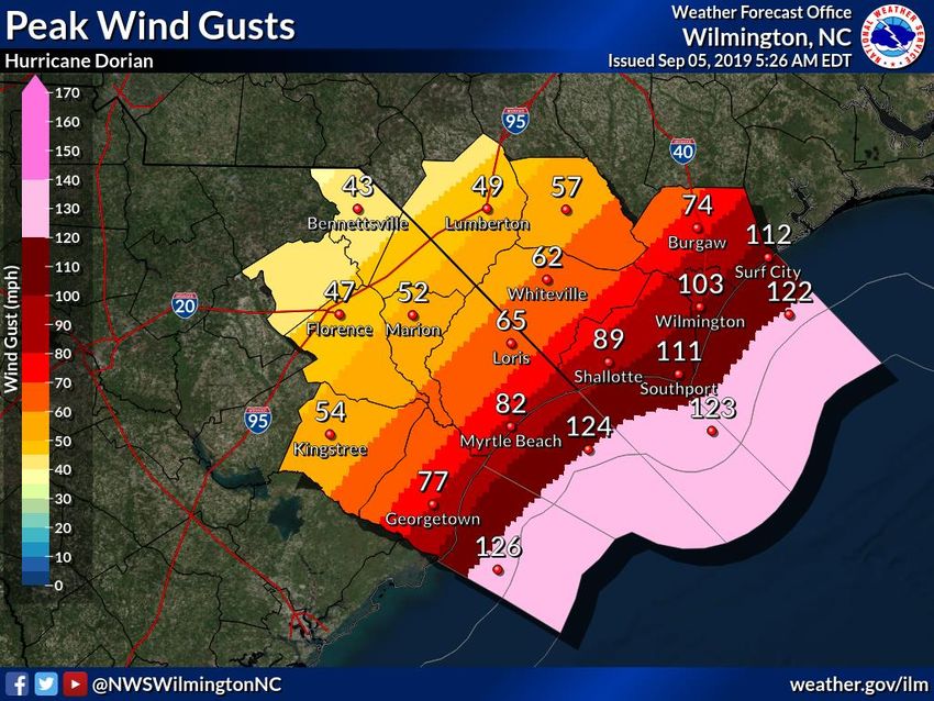
Situation Overview Wilmington, NC
Hurricane Dorian WEATHER FORECAST OFFICE
Dorian is approaching from the south and will move
close to the upper SC coast this afternoon and
evening, and track very close to the southeast NC
coast tonight.
The hurricane is forecast to begin accelerating away
from the Cape Fear area late tonight into early Friday
morning.
Please note that given the sharp angle of incidence as
the storm moves up the coast that any subtle change
to the storm’s track can still significantly alter the
impacts received across the area.
Reminder: Impacts can occur well outside the area
NOTE: Do not focus on the exact track. Impacts can occur outside the area enclosed by the cone. enclosed by the cone.
9/5/2019 6:35 AM www.weather.gov/ilm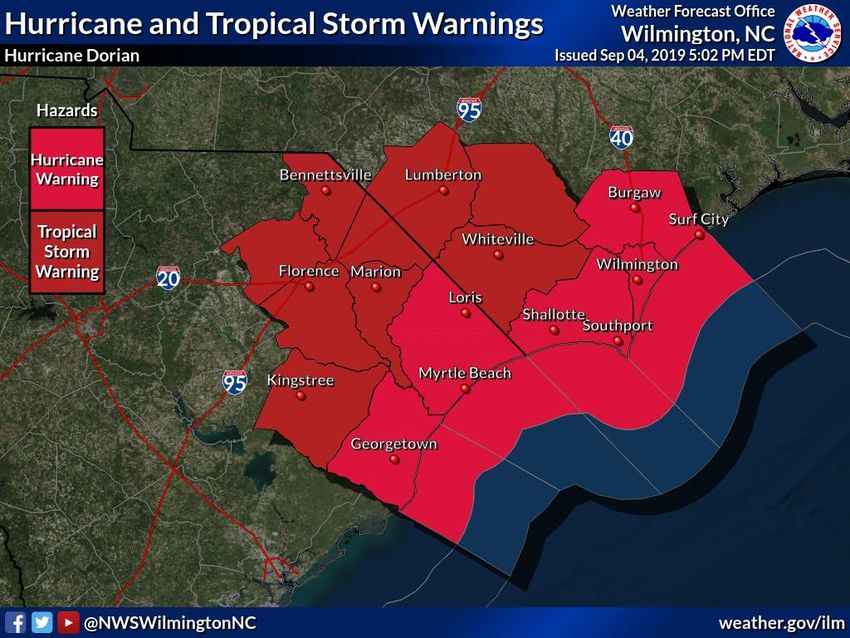
Threat Levels                                                                                      Wilmington, NC
    Hurricane Dorian                                                                            WEATHER FORECAST OFFICE

                                                       Increasing Threat
                               Rainfall/                                    For information on specific hazards in this area,
           Winds       Surge               Tornadoes                       please go to https://www.weather.gov/ilm/tropical
                               Flooding
9/5/2019 6:35 AM                                                                                               www.weather.gov/ilm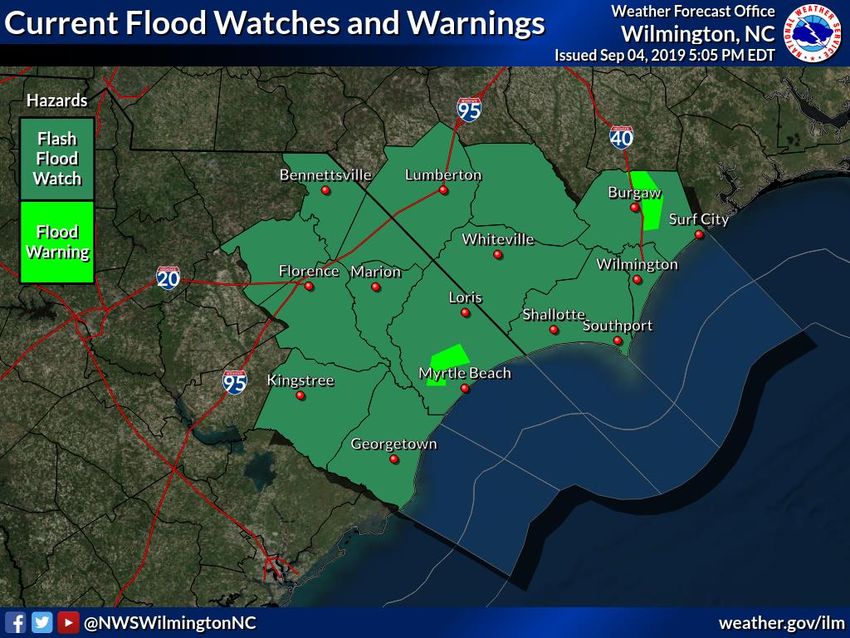
Peak Wind Swath (MPH)                               Wilmington, NC
     Hurricane Dorian                            WEATHER FORECAST OFFICE
                        •   Hurricane force winds are possible for the coastal
                            northeast SC this afternoon into the early evening for
                            parts of Horry County. Hurricane force winds are
                            likely for coastal southeast NC this evening into the
                            overnight hours early Friday morning.

                        •   Based on the latest track sustained winds of 65 to 90
                            mph are expected along the coastal areas. Winds of 30
                            to 55 mph are expected farther inland.

                        •   Impacts in the areas with the highest winds include:
                            downed trees & power lines, some structural damage
                            – especially to weak structures & roofs, fences and
                            signs blown down.

                        •   Winds improving by late evening for northeast SC,
                            and mid-morning Friday for southeast NC areas.

                        •   Note: these winds speeds are highly dependent on the
                            storm’s track. Any subtle change and these conditions
                            will change.
9/5/2019 6:35 AM                                                 www.weather.gov/ilm
Peak Wind Gusts (MPH)                           Wilmington, NC
     Hurricane Dorian                        WEATHER FORECAST OFFICE

                        •   Note: these wind gusts are highly
                            dependent on the storm’s track. Any
                            subtle change and these conditions will
                            change.
                        •   Based on the latest track wind gusts of 70
                            to 100+ mph are possible along coastal
                            areas (highest in the vicinity of Cape Fear
                            through Surf City). Gusts of 45 to 65 mph
                            are expected farther inland.

9/5/2019 6:35 AM                                          www.weather.gov/ilm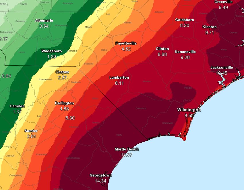
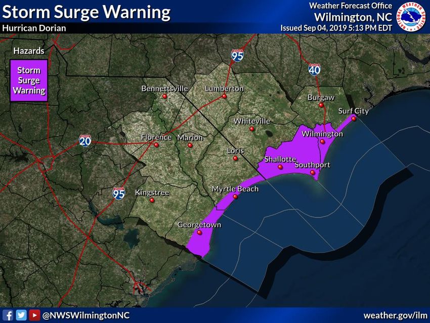
Storm Surge Warning in Effect                                                        Wilmington, NC
     Hurricane Dorian                                                             WEATHER FORECAST OFFICE
                                                          •   Surge impacts are expected especially over the next
                                                              couple high tides.

                                                          •   NE SC will see the worst with high tide early this
                                                              afternoon

                                                          •   Coastal SE NC will see the worst conditions during
                                                              this high tide this afternoon and late tonight/early
                                            4-7 ft.           Friday morning.
                                                4-7 ft.
                               4-7 ft.                    •   Potential for 5 to 8 ft inundation from Myrtle Beach
                                  4-7 ft.
                                                              south, and 4 to 7 ft inundation north of Myrtle
                        5-8 ft.                               Beach. Surge impacts also likely along vulnerable
                             5-8 ft.                          locations around Winyah Bay including the city of
                                                              Georgetown, SC.

                                                          •   Wave activity combined with the surge will also lead
                                                              to severe erosion and ocean overwash, with most
                                                              severe impacts for our east facing beaches. Piers, and
                                                              structures in areas with a weakened shoreline
                                                              infrastructure are at risk for damage.
9/5/2019 6:35 AM                                                                                  www.weather.gov/ilm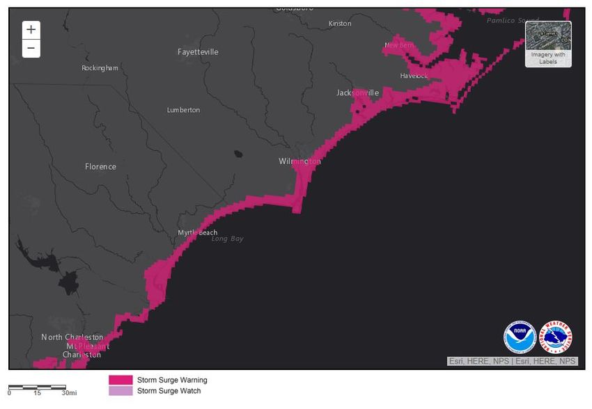
Expected Storm Total Rainfall Wilmington, NC
Hurricane Dorian WEATHER FORECAST OFFICE
Valid through 8 PM EDT Fri Sep 6, 2019 ***Life threatening Flash Flooding Likely***
Note: There will likely be locally higher amounts
STORM TOTAL RAINFALL amounts will range from 10
to 15 inches with isolated higher amounts possible.
Rainfall totals will be lower farther northwest. A Flash
Flood Watch is in effect.
FLOODING IMPACTS include: the potential for road
failures/scours, rapid rises in small streams and creeks
that may over-top their banks, flooding across
vulnerable low-lying and prone locations. Driving will
become very hazardous with some road closures
possible.
DO NOT DRIVE THROUGH FLOODED ROADWAYS
TIMING – The heaviest rainfall will occur today through
tonight, improving earlier across northeast SC and into
Friday morning for southeast NC.
9/5/2019 6:35 AM www.weather.gov/ilm
Tornado Potential Wilmington, NC
Hurricane Dorian WEATHER FORECAST OFFICE
Tornado Watch in effect. Isolated
tornadoes are possible.
Risk highest through the early afternoon
for coastal northeast SC, and through
the afternoon for southeast North
Carolina.
9/5/2019 6:35 AM www.weather.gov/ilmPeak Wave Heights Wilmington, NC
Hurricane Dorian WEATHER FORECAST OFFICE
• As Dorian makes its closest
approach later this afternoon and
tonight wave heights across the
adjacent coastal waters will range
from 15-25 feet.
• Seas farther offshore could exceed
25 to 30 feet.
• Conditions will gradually improve
during Friday, but more-so Friday
night.
9/5/2019 6:35 AM www.weather.gov/ilmKey Take Away Messages Wilmington, NC
Hurricane Dorian WEATHER FORECAST OFFICE
• Tropical Storm force winds are likely, with hurricane force winds expected along the coast. The storm’s
closest approach will be later this afternoon through tonight & Dorian will bring a variety of impacts to the
area. Power outages, downed trees, and some structural damage becoming more likely, especially closer to
the coast.
• The risk for storm surge is increasing with the greatest risk with through tonight. However, the amount
of inundation is highly dependent on the tide cycle and the storm’s track.
• Life threatening flash flooding is likely, especially today through tonight, with 10 to 15 inches expected along
coastal areas. Isolated higher amounts are also possible. People that live along rivers should be prepared
for minor to moderate flooding, especially rivers closer to the coast. Driving will become dangerous as there
may be road failures or roads covered with deep water.
• Isolated tornadoes possible today.
• Severe surf and marine conditions expected today through tonight into Friday morning.
9/5/2019 6:35 AM www.weather.gov/ilmContact and Next Briefing Information
Next Briefing:
When: As needed today
Method: E-mail
Web: http://weather.gov/ilm Facebook: NWSWilmingtonNC
Phone: (910) 762-4289 Twitter: NWSWilmingtonNC
E-mail: nws.ilm.operations@noaa.gov YouTube: NWSWilmington
ILM Tropical Briefing Webpage: https://www.weather.gov/ilm/tropical
NWSWilmingtonNC www.weather.gov/ilmYou can also read