2011 Northwest Area Fire Weather Annual Operating Plan - State of ...
←
→
Page content transcription
If your browser does not render page correctly, please read the page content below
2011
 Seattle

 Portland

 Medford

 Spokane      Northwest Area
Pendleton      Fire Weather
  Boise      Annual Operating
ODF Salem          Plan
 NWCC
Predictive
 Services
Table of Contents
Introduction………………………………………………………………..3

NWS Services and Responsibilities……………………………………….4

Wildland Fire Agency Services and Responsibilities……………………..8

Joint Responsibilities……………………………………………….……..9

New for 2011……………………………………………………………..10

Seattle……………………………………………………………………..11

Portland………………………………………………………………..….22

Medford………………………………………………………….…….….34

Spokane…………………………………………………….……………..45

Pendleton……………………………………………………….…….…...57

Boise…………………………………………………….……………..….68

ODF Salem Weather Center………………………………………………74

NWCC Predictive Services……………………………………………….78

Plan Approval……………………………………………………………..84

Appendix A: Links to Fire Weather Agreements and Documents…….…85

Appendix B: Forecast Service Performance Measures…………………..86

Appendix C: Reimbursement for NWS Provided Training……………...87

Appendix D: IMET Reimbursement Billing Contacts…………………...88

Appendix E: Spot Request WS Form D-1……………………………….89

                                  2
INTRODUCTION

a. The Pacific Northwest Fire Weather Annual Operating Plan (AOP) constitutes an agreement
   between the Pacific Northwest Wildfire Coordinating Group (PNWCG), comprised of State,
   local government and Federal land management agencies charged with the protection of life,
   property and resources within the Pacific Northwest from threat of wildfire; and the National
   Weather Service (NWS), National Oceanic and Atmospheric Administration, U.S.
   Department of Commerce, charged with providing weather forecasts to the Nation for the
   protection of life and property.

   The AOP provides specific procedural and policy information for the delivery of fire weather
   information to the fire management community in Pacific Northwest. It is the objective of
   the NWS and PNWCG to ensure that quality of service is maintained through a mutual
   analysis of services provided. The NWS and PNWCG work closely in all phases of the fire
   weather forecast and warning program to resolve concerns and avoid potential
   inconsistencies in products and services prior to delivery to fire agency customers. The goal
   of all agencies is to maximize firefighter and public safety through a coordinated delivery of
   consistent services.

   Fire weather services are a critical building block to fire management agencies in decision-
   making because human lives and valuable natural resources are at risk. It is the role of the
   NWS to provide fire weather services and products to fire managers. It is the role of the fire
   management agencies to analyze and interpret fire weather forecasts into fire danger and fire
   potential predictions when making decisions essential to the success of fire management
   actions.

   It is to the mutual advantage of PNWCG and NWS and in the public interest and for
   firefighter safety to coordinate efforts for weather services for fire management activities in
   the Pacific Northwest to minimize duplication of efforts and improve efficiency and
   effectiveness.

b. The general relationship between the NWS and the interagency fire management community
   is set forth in the following reference documents:

   Interagency Agreement for Meteorological Services Among the Bureau of Land
   Management, Bureau of Indian Affairs, U.S. Fish and Wildlife Service, and National Park
   Service of the U.S. Dept. of Interior, the Forest Service of the U.S. Dept. of Agriculture,
   and the National Weather Service of the U.S. Dept. of Commerce (National MOA or
   National Agreement);

   National Weather Service NWSI 10-4: Fire Weather Services;

   2011 National Mobilization Guide; and

   Pacific Northwest Mobilization Guide

                                                 3
c. The PNWCG is comprised of the following Federal and State fire agencies: State of
      Oregon, Department of Forestry; State of Washington, Department of Natural Resources;
      USDA Forest Service, Pacific Northwest Region; USDI, National Park Service, Pacific
      West Region; USDI, Fish and Wildlife Service, Pacific Region; USDI, Bureau of Indian
      Affairs, Portland Area Office; USDI, Bureau of Land Management, Oregon and
      Washington.

NWS SERVICES AND RESPONSIBILITIES

The National Weather Service will collaborate with the fire agencies when proposing alterations
to the fire weather program and services provided in the Pacific Northwest. NWS-developed
proposals are provided to PNWCG for review, assessment, and comment prior to adoption and
implementation. NWS considers any concerns expressed by PNWCG, especially as related to
performance integrity, in its assessment of change proposals in the fire weather program and
other services provided.

Fire Weather Services

1. CORE GRIDS AND WEB-BASED FIRE WEATHER DECISION SUPPORT

   National Digital Forecast Database (NDFD) grids are used to produce a wide variety of
   products and services for fire weather support. Operational status of NWS grid elements is
   available at the following website:

   http://www.weather.gov/ndfd/resources/NDFD_element_status.pdf.

   NWS offices produce several web-based digital planning tools to assist fire weather
   customers. These include FARSITE weather input data, Hourly Weather Graphs, Point
   Forecast Matrices and Activity Planners. Please contact your local servicing NWS office
   with any questions or for more information.

2. FIRE WEATHER WATCHES AND RED FLAG WARNINGS

   Fire Weather Watches and Red Flag Warnings are issued when the combination of dry fuels
   and weather conditions support extreme fire danger and/or fire behavior. These statements
   alert land management agencies to the potential for widespread new ignitions which could
   overwhelm Initial Attack activities, or conditions which could cause control problems on
   existing fires, etc. Any of these outcomes could pose a threat to life and property.

   Fire Weather Watch: A Fire Weather Watch is issued when there is a high potential for the
   development of a Red Flag Event. A watch is issued 18 to 96 hours in advance of the
   expected onset of criteria. The watch may be issued for all, or selected portions within a Fire
   Weather Zone or region. The overall intent of a Fire Weather Watch is to alert forecast users
   at least a day in advance for the purposes of resource allocation and fire fighter safety.

                                                4
Red Flag Warning: A Red Flag Warning is used to warn of impending, or occurring Red
  Flag conditions. Its issuance denotes a high degree of confidence that weather and fuel
  conditions consistent with local Red Flag Event criteria will occur in 48 hours or less.
  Longer lead times are allowed when confidence is very high or the fire danger situation is
  critical. Forecasters can issue a warning for all or selected portions within a Fire Weather
  Zone.

  Prior to issuance, all Red Flag Warnings are coordinated with affected agencies and
  neighboring fire weather offices, in order to assess fuel conditions and general fire danger.
  Each issuance, update or cancellation of a Fire Weather Watch or Red Flag Warning is also
  relayed by telephone to the dispatch office(s) affected by the watch/warning. Red Flag
  Warnings and Fire Weather Watches will be issued using a bulleted format.

3. SPOT FORECASTS

  Spot forecasts are site specific forecasts issued by the NWS in support of wildfire
  suppression and natural resource management. Spot forecasts may also be issued for
  hazardous materials incidents, search and rescue missions and other threats to public safety.
  All spot forecast requests should be accompanied by a representative onsite weather
  observation.

  Issuance Criteria: Spot forecasts are non-routine products issued at the request of the user.
  WFOs will provide spot forecast service upon request of any federal, state, tribal, or local
  official who represents the spot forecast is required to support a wildfire.

  For non-wildfire purposes, resources permitting, WFOs will provide spot forecast service
  under the circumstances and conditions outlined in NWS Instruction 10-401
  http://www.weather.gov/directives/sym/pd01004001curr.pdf.

  Spot forecasts will not be provided to private citizens or commercial entities not acting as an
  agent of a government agency.

  Requesting a Spot Forecast: Spot forecast requests are normally made via the Internet
  through local NWS fire weather pages or from http://www.weather.gov/fire. When web
  access is not available, spot forecasts may be requested and disseminated via fax - using the
  spot forecast request form D-1 (NWSI-401) in appendix E. An electronic fillable pdf version
  of WS form D-1 can be found at
  http://www.nwccweb.us/content/products/fwx/publications/NW_AOP/spotRequestForm.pdf

  The requestor must provide information about the location (latitude/longitude), slope aspect,
  drainage name, fuel types, top and bottom elevations of fire or project, size of fire or project,
  ignition time, and contact names and telephone numbers of the responsible land management
  personnel. It is critically important that each spot forecast request also include quality,
  representative observations at, or near, the site. A detailed description of the
  observation location relative to the project (if not at the site) should be provided. The

                                                5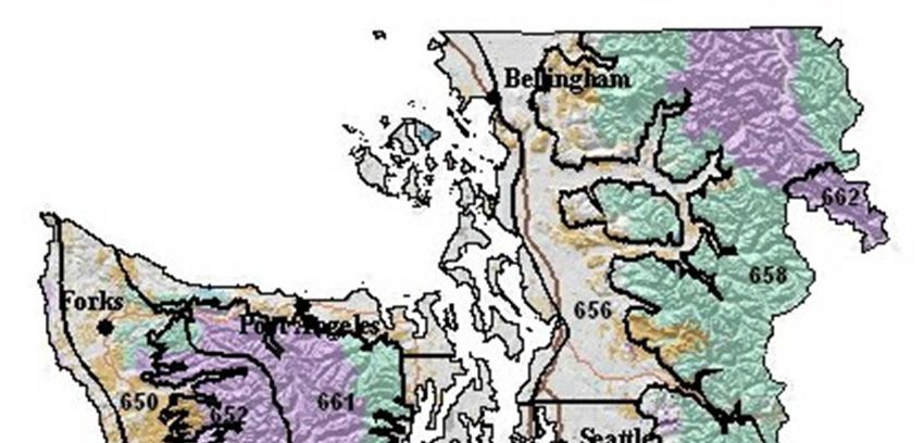
description should include, at a minimum, distance and direction from the project or
  fire site, station elevation and aspect.

  Fire agencies are strongly encouraged to call the WFO after submitting a spot request to
  ensure it was received properly. The WFO will attempt to notify field personnel and/or the
  dispatch office whenever there is a significant change in the expected weather.

  For more detailed instructions on using NWS Spot please see:
  http://www.nwccweb.us/content/products/fwx/publications/NW_AOP/NW_SpotRequestInstructions.pdf

  Updates: Spot forecasts are considered one-time requests, and are not routinely updated.
  Spot forecasts may be updated when new representative observations are available to the
  forecaster or if the forecaster deems the current forecast does not adequately represent
  current or expected weather conditions. Land or emergency management personnel are
  encouraged to contact the appropriate WFO for a spot update if forecast conditions appear
  unrepresentative of the actual weather conditions. The spot forecast will be corrected when a
  typographical or format error is detected that could confuse the intended meaning. Updated
  and corrected spot forecasts will be delivered to users in the same manner as the original spot
  forecast when possible.

  Spot Forecast Feedback: Good communication between fire managers and the NWS is
  critical for quality spot forecast services. Land management personnel should provide
  feedback to the NWS forecasters about the quality and accuracy of the spot forecast.
  Responsibility for providing fire line observations for the verification of forecast accuracy
  rests with the land management agencies. Onsite observations taken during the operational
  period the forecast is valid for are to be provided back to the WFO via the feedback box
  online spot forecast form, or by phone, fax or email.

4. FIRE WEATHER PLANNING FORECASTS

  The Fire Weather Planning Forecast is a zone-type product used by land management
  personnel primarily for input in decision-making related to pre-suppression and other
  planning. The decisions impact firefighter safety, protection of the public and property, and
  resource allocation. Weather parameters represent average conditions across the given zone.

  Headlines are included in the Fire Weather Planning Forecast (FWF) whenever a Red Flag
  Warning or Fire Weather Watch is in effect or to highlight other critical weather information.
  A brief, clear, non-technical discussion of weather patterns that will influence the forecast
  area will begin the forecast with the emphasis on the first two days of the forecast period. A
  discussion of latter periods will be included if significant weather is expected to impact
  safety or operations. Sky and weather, maximum and minimum temperature and relative
  humidity, wind speed and direction, Haines index, Lightning Activity Level and chance of
  wetting rain are included in the FWF by all of the WFOs in the Pacific Northwest. Several
  offices also forecast mixing height and transport winds.

                                                 6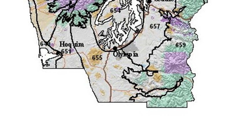
Two forecasts will be issued daily during fire season – a morning forecast between 5 AM and
  9 AM and an afternoon forecast around 3 PM. Once per day forecasts will continue through
  the spring and fall burning seasons at the request of the land managers with some offices
  continuing land management forecasts through the winter. Local start and stop dates shall be
  coordinated between the NWS offices and fire weather customers, including the geographic
  area Predictive Services Units.

5. NFDRS FORECASTS

  The National Weather Service role in NFDRS is forecasting weather input which, combined
  with fire agency input, allows the NFDRS software in WIMS to predict the next day's fire
  danger indices. These indices impact agency resource management decisions, firefighter
  safety, and protection of the public and property.

  Numerical point and/or zone trend forecasts for NFDRS stations are prepared and
  disseminated to WIMS by 1545 each afternoon from April or May through early October.
  The point forecasts are used to compute the expected NFDRS indices valid the following
  day. The number of NFDRS point forecasts made by the weather office depends only on the
  number of NFDRS observations input into WIMS by the fire agencies. If observations are
  not entered into WIMS by 1500 however, a forecast will not be produced for those stations.

6. TELEPHONE BRIEFINGS

  All NW NWS Offices provide daily fire weather phone briefings each morning during fire
  season. Local Fire weather users are encouraged to participate in these briefings. The
  forecaster hosting the briefing will verbally highlight current and forecast fire weather
  conditions with the help of weather graphics on an internet web page or through a
  GoToMeeting® webinar. Briefing times, conference call telephone numbers and passcodes
  can be obtained by contacting the local WFO. A link to the web briefings can be found on
  the local fire weather page.

7. FORECAST VERIFICATION

  Routine verification is made on Red Flag Warnings and NFDRS forecasts. Results of the
  verification will be published in the Fire Weather Annual Summary. Spot forecast
  turnaround time and other statistics are available from your local NWS office.

8. INCIDENT METEOROLOGIST SERVICES

  Each WFO in the Pacific Northwest has 2 to 3 Incident Meteorologists (IMETs) on staff
  available for wildfire, HAZMAT, Search and Rescue or other emergency dispatches. To
  request an IMET, contact the appropriate fire agency dispatch office.

                                             7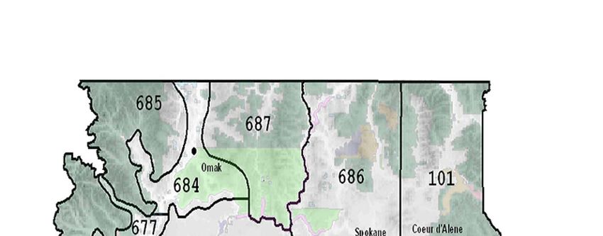
9. NON-FORECAST SERVICES:
There are several duties that fall into the non-forecast services including, but not limited
to teaching assignments, customer meetings, customer consultations, preparation of
annual reports, preparation of annual operating plans, program management, research
and in-house training of personnel.
Experienced fire weather forecasters will be available to help instruct the weather
sections of standard fire behavior training courses offered by federal, state and local
government fire agencies. This includes S-190 through S-590 and other courses. In
addition, a forecaster will also be available for special speaking engagements and
customer consultations. For scheduling purposes, requests for an instructor or speaker
should be made at least three weeks in advance.
WILDLAND FIRE AGENCY SERVICES AND RESPONSIBILITIES
Provide coordination and recommendations for interagency fire weather activities in Oregon and
Washington through the PNWCG. Continually review standards of performance for
applicability and adequacy.
Provide weather observations seven days a week during fire season and coordinate and cooperate
with the NWS in fire weather forecasting. The agencies will seek the advice and counsel of the
NWS regarding observational issues (e.g. moving remote automatic weather stations).
Recognize that other severe weather emergencies may require the services of the fire weather
forecaster to assist in WFO operations.
USER AGENCY RESPONSIBILITIES:
There are several responsibilities of the user agencies including:
Entering of 1300 PST NFDRS observations in WIMS.
Site observations for Spot forecast requests. A representative observation from the burn
site is required for all prescribed fire spot forecast requests.
Quality Control of RAWS observations
Timely maintenance of RAWS sites.
8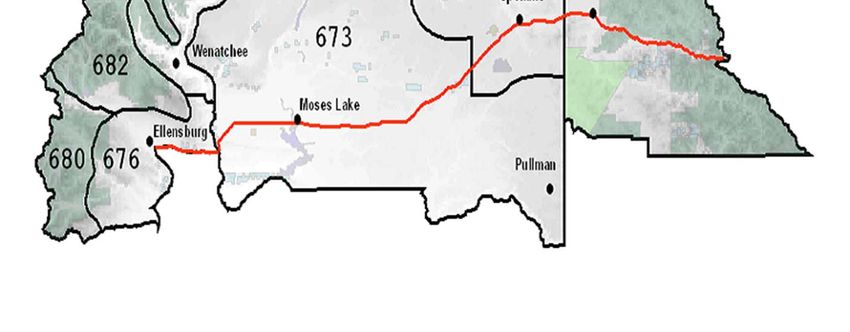
JOINT RESPONSIBILITIES

Work cooperatively as partners to maintain and improve fire weather services to assure full
compliance with mutually established performance, reliability, priority, and time standards.

Recognize that lands for which the States are responsible for wildland fire protection in Oregon
and Washington, and the lands for which the respective Federal Agencies are responsible, are
intermingled or adjacent in some areas, and wildland fires on these intermingled or adjacent
lands may present a threat to the lands of the other. Recognize the primary role of the States in
administering smoke management plans in their respective states.

Prepare an Annual Operating Plan (AOP – this document) that includes each WFO with fire
weather areas of responsibility in Oregon and Washington as required in the National Fire
Weather Agreement and fire and smoke management responsibilities (as appropriate) of DNR,
ODF and NWCC Predictive Services. Fire weather zone and Predictive Service Area maps will
be included in the AOP. The AOP will meet the guidelines specified in NWSI 10-404:
http://www.nws.noaa.gov/directives/sym/pd01004004curr.pdf

Annually review the performance of the NWS and NWCC Predictive Services in meeting the
needs of the fire management community. This review will be used to help determine what
program adjustments are needed and appropriate. PNWCG directed subject matter experts
(SMEs) and the NWS MICs from Boise, Medford, Pendleton, Portland, Seattle and Spokane
shall conduct the review. NWCC Predictive Service, the NWS, PNWCG SMEs and any
interested members of the fire community shall meet annually around February. The meeting
will evaluate the past season fire weather services and recommend changes for the next fire
season. Proposed changes in fire weather services for the upcoming fire weather season will be
discussed and if agreed upon reflected in the AOP. AOP sections from individual offices are
expected to be finalized no later than April 1st (drafts are requested the February meeting) so that
the compiled Pacific Northwest AOP can be submitted to the PNWCG and NWS signatories for
final approval. Changes after April 1st should, if at all possible, be held off until after fire season.
If extenuating circumstances require significant additional changes to be made for the current
fire season, the AOP will need to be reapproved by the signing officials.

Respond to the other party's proposals within thirty (30) days, or advise the other party when the
proposal will be addressed if the NWS or the PNWCG are unable to meet or discuss the proposal
within their respective groups in that time frame. Except when necessary to meet emergency
needs, significant proposals are expected to be discussed at the annual meetings

Cooperate and coordinate plans for the weather-related training of fire personnel and fire weather
forecasters to ensure that training needs are met.

Collaborate in fire weather research and development.

                                                   9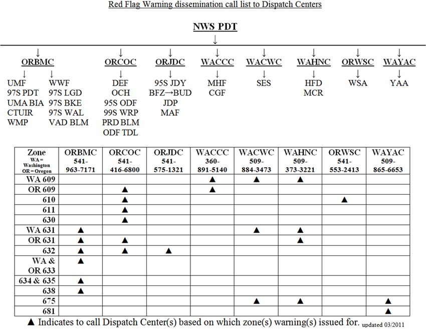
New for the 2011 Fire Season
The experimental bulleted format for Fire Weather Watch and Red Flag Warning
statements which was tested in 2010 will become operational for the 2011 fire season.
First period Fire Weather Watches will no longer be allowed. The clause which allowed
Fire Weather Watches for dry lightning within the first 12 hour period of the forecast has
been removed from the national directives. Local policy for most NW office had already
been not to issue these but rather to either upgrade the watch to a warning or cancel the
watch if confidence in the event was too low.
An experimental change to the Fire Weather Planning Forecast (FWF) format will be
implemented by Pacific Northwest National Weather Service offices beginning on June
1st this year. No change to the content will occur. The format change is intended to
produce a shorter and visually cleaner product that will facilitate faster editing by
National Weather Service forecasters via removing larger indents. An example period
follows (note that not all elements included below are forecast by all offices):
.TODAY...
* SKY/WEATHER.........SUNNY IN THE MORNING...BECOMING
PARTLY CLOUDY IN THE AFTERNOON WITH A SLIGHT CHANCE OF
SHOWERS.
* LAL.................1.
* MAX TEMPERATURE.....62-68 VALLEYS AND 54-62 MOUNTAINS.
* 24 HR TREND.......1 DEGREE WARMER.
* MIN HUMIDITY........30-45 PERCENT.
* 24 HR TREND.......5 PERCENT DRIER VALLEYS AND 5 PERCENT
WETTER MOUNTAINS.
* 20-FOOT WIND........
* VALLEYS/LWR SLOPES...UPSLOPE/UPVALLEY 2 TO 5 MPH.
* RIDGES/UPR SLOPES....VARIABLE 2 TO 5 MPH.
* HAINES INDEX........2 VERY LOW.
* MIXING HEIGHT.......3000 FT AGL.
* TRANSPORT WINDS.....WEST 3 TO 7 MPH IN THE MORNING
SHIFTING TO THE SOUTHWEST IN THE AFTERNOON.
* CWR (> 0.10 IN).....0 PERCENT.
Please provide feedback on this experimental change to your local forecast office.
102011
Seattle Fire Weather
Operating Plan
Changes for 2011:
NWS Products and Services that are common to all six field offices in the PNW have been
consolidated into a section on NWS Services and Responsibilities.
Adjusted dates for Fire Weather desk staffing.
DNR will replace the manual Elbe NFDRS site with a RAWS site at Columbia Crest
Elementary School near Ashford in time for the 2011 fire season.
LOCATION
The National Weather Service Forecast Office in Seattle is located at the NOAA Western
Regional Center in northeast Seattle. The address is:
NOAA/National Weather Service
7600 Sand Point Way N.E.
Seattle, WA 98115-0070
HOURS OF OPERATION
The National Weather Service Office in Seattle is open 24 hours a day, 7 days a week, every day
of the year. During Fire Season, the Fire Weather Desk is staffed by a certified and experienced
Fire Weather Forecaster between the hours of 7:00 a.m. and 5:00 p.m.
In 2011, weekday Fire Weather desk staffing and twice-a-day Fire Weather Planning Forecasts
will begin on or around May 25 (the Wednesday before Memorial Day).
Seven-day-a-week Fire Weather Desk staffing will begin no later than Monday, June 27, but
weekend coverage could begin sooner if fuels, weather conditions, or user needs warrant. The
need for continued Fire Weather desk staffing will start being evaluated around Oct. 1. The
exact dates of Fire Weather desk staffing can be adjusted based on weather conditions and user
requirements or requests.
11After hours during Fire Season and during the off-season, Spot Forecast support or phone
briefings will be handled by staff meteorologists, trained in Fire Weather forecasting, on a 24/7
basis. A Fire Weather Forecaster can be made available with prior arrangements.
Certified Fire Weather Forecast Staff
Andy Haner – Co-Fire Weather Program Leader/IMET
Carl Cerniglia – Co-Fire Weather Program Leader/IMET
Brad Colman – Meteorologist in Charge
Ted Buehner – Warning Coordination Meteorologist
Kirby Cook – Science and Operations Officer
Brent Bower - Service Hydrologist
Danny Mercer – Fire Weather Forecaster/Instructor
Jeff Michalski – Fire Weather Forecaster
Doug McDonnal – Senior Forecaster
PHONE NUMBERS
Brad Colman, Meteorologist in Charge (206) 526-6095 ext 222
Andy Haner, Co-Program Leader (206) 526-6095 ext 251
Carl Cerniglia, Co-Program Leader (206) 526-6095 ext 252
E-MAIL
andrew.haner@noaa.gov
carl.cerniglia@noaa.gov
brad.colman@noaa.gov
INTERNET
Our Internet home page can be found at:
http://www.wrh.noaa.gov/sew/ or http://www.weather.gov/seattle
Click the “Fire Weather” link on the main left-hand menu to access Fire Weather products.
FORECAST DISTRICT
The Seattle Fire Weather Office has forecast responsibility for most state and federal land in
Western Washington. The Portland Fire Weather Office handles the Gifford Pinchot National
Forest south of a line from Mt. St. Helens to Mt. Adams. The Seattle Fire Weather area of
responsibility is divided into 7 distinct areas or districts for Fire Weather forecasting. The areas
are further sub-divided into 13 separate Fire Weather Zones. Each Fire Weather Zone is
comprised of Fire Weather stations that exhibit similar weather and/or weather changes.
12FORECAST PRODUCTS
1. CORE GRIDS
An overview of gridded products is given in the NWS Services and Responsibilities section
in the region-wide AOP.
2. FIRE WEATHER WATCHES AND RED FLAG WARNINGS
Fire Weather Watches and Red Flag Warnings will be issued when the combination of dry
fuels and weather conditions support extreme fire danger and/or fire behavior. A further
overview of the Fire Weather Watch and Red Flag Warning programs is given in the NWS
Services and Responsibilities section of the region-wide AOP.
A. LOCAL CRITERIA FOR FUEL DRYNESS
Fire Weather Watches and Red Flag Warnings will be considered in the Seattle Fire
Weather District when the Energy Release Component (ERC), as described by the
National Fire Danger Rating System (NFDRS), is equal to or greater than the 90th
percentile value in the frequency distribution of historical ERCs. For the Fire Weather
Zones above 1500 feet of elevation, the Northwest GACC Dryness Levels will also be
considered when in the “Yellow” or “Brown” category.
The conditions described below must either be occurring or forecast to occur. The table
below shows the 90th percentile ERC values that will be used for each Fire Weather
Zone.
Zone 649: 17
Zones 650, 651, 653, 656, 657 25
Zones 652, 654, 655, 658, 659 31
Zone 661 34
Zone 662 73
B. LOCAL CRITERIA FOR WEATHER
Strong East Winds and Low Humidity (Westside zones only)
Nighttime hours (midnight to 7 am):
Duration: 5 consecutive hours
Wind Speed: 20 ft /10 min sustained greater than or equal to 10 mph (RAWS)
- OR –
30 ft /2 min sustained greater than or equal to 12 mph (ASOS)
RH: less than or equal to 35%.
13 Daytime hours (7 am to midnight):
Duration: 4 hours in an 8-hour block
Wind Speed: 20 ft/10 min sustained greater than 10 mph (RAWS)
- OR –
30 ft /2 min sustained greater than 12 mph (ASOS)
RH: less than or equal to 30%, except less than or equal to 25% on the
Gifford-Pinchot NF south of the Cowlitz River.
Verifying Stations for Strong East Wind episodes are listed and described in Appendix 3.
Strong West Winds and Low Humidity (Eastside Zone 662 only)
Duration: at least 4 hours
Wind Speed: 20 ft /10 min sustained greater than or equal to 15 mph (RAWS)
RH: less than or equal to 25%.
Stehekin and Camp Four RAWS sites will be used to verify Red Flag Warnings in Zone
662.
The conditions described above for Wind and Low Humidity events should be fairly
widespread in both time and space across the Fire Weather Zone - as opposed to an
isolated incident or a diurnal occurrence that lasts for only a few hours.
Lightning
Weather Criteria for lightning is defined as significant lightning, either wet or dry, within
a particular Fire Weather Zone. The thunderstorm activity must be at least scattered (25-
54% aerial coverage) or greater within a particular zone; the forecast LAL must be 3 or
higher.
Very Dry and Unstable Air Mass
Western Washington Fire Weather Zones 649-661: Mid and High-level Haines of a 5 or
6, and RH of 25% or less.
Eastern Washington Fire Weather Zone 662: High-level Haines of a 6 and RH of 15% or
less.
The most current Quillayute, Salem, and Spokane soundings will be used to produce the mid-
and high-level Haines values used to issue and verify this Red Flag Warning event.
143. SPOT FORECASTS
An overview of the Spot Forecast program is given in the NWS Services and Responsibilities
section of the region-wide AOP.
Requesting a Spot Forecast from NWS Seattle: From Seattle’s Fire Weather web site at
“http://www.wrh.noaa.gov/firewx/?wfo=sew”, click the red “Spot Request” Button in the
upper-left corner of the page. On the next page, click “Submit a new Spot Request”, then fill
out the form. Detailed instructions for completing the Spot Request Form are available at:
http://www.wrh.noaa.gov/sew/SpotRequestInstructions.pdf.
4. FIRE WEATHER PLANNING FORECASTS
An overview of Fire Weather Planning Forecasts is given in the NWS Services and
Responsibilities section of the region-wide AOP.
During the "fire season", NWS Seattle issues twice-daily Fire Weather Planning Forecasts by
8:30 AM PDT and 3:30 PM PDT. A scaled-down version of the Fire Weather Planning
Forecast will be issued once daily from Monday through Friday during the "off-season",
roughly from mid-October to mid-May. The off-season forecasts are available in WIMS and
on the Internet by 9:00 AM PT.
5. NFDRS TREND FORECASTS
An overview of NFDRS Trend Forecasts is given in the NWS Services and Responsibilities
section of the region-wide AOP. NWS Seattle will continue to issue these forecasts as zone
averages in 2011.
6. INTERNET-BASED BRIEFING CALLS
Statewide, Internet-based, Fire Weather briefing calls will be conducted each day at 9:00
a.m. during peak fire season, and as needed near the beginning and end of the season.
Contact this office for the appropriate telephone number and conference ID to participate in
the conference calls.
AGENCIES SERVED
The Seattle Fire Weather Office serves the following state and federal land management
agencies:
U.S. Forest Service - Olympic National Forest, Mt. Baker-Snoqualmie National Forest, Gifford-
Pinchot National Forest and Okanogan-Wenatchee National Forest
National Park Service - North Cascades National Park, Olympic National Park, Mt. Rainier
National Park and San Juan Islands National Historical Park
Bureau of Indian Affairs - Olympic Peninsula Agency and Puget Sound Agency
15Washington Department of Natural Resources -
Resource Protection Division and the Northwest, Olympic, South Puget Sound, and Pacific
Cascade regions
Department of Defense – Joint Base Lewis-McChord Forestry Program
Seattle Fire Weather Zones
Appendix 1: Fire Weather Zone Descriptions
Appendix 2: NFDRS Fire Weather Station List
Appendix 3: Stations Verifying East Wind Events
16Appendix 1
FIRE WEATHER ZONE BOUNDARY DESCRIPTIONS
Zone 649 – The North and Central Coastal Strip: The western boundary of Fire Weather
Zone 649 is the Pacific coastline in Clallam, Jefferson, and Grays Harbor counties. The eastern
boundary includes all land within 5 miles of the Pacific coastline in Clallam, Jefferson, and
Grays Harbor Counties. It extends south along the eastern border of the Makah Indian
Reservation and the east shore of Ozette Lake to the town of Quillayute in Clallam County. In
Jefferson County, the eastern boundary crosses US Highway 101 approximately 5 miles east of
the Hoh Indian Reservation, and then parallels the coast south until crossing US Highway 101
again along the border between Jefferson and Grays Harbor counties 5 miles inland from the
coast. The eastern border continues south in Grays Harbor County until it crosses highway 101 at
New London and US Highway 12 approximately 5 miles east of Aberdeen. The boundary then
turns south, following US Highway 101 to the southern border of Grays Harbor County.
Zone 650 – The North Coastal Lowlands: Zone 650 includes all land 5 miles inland from the
coast to an elevation of 1500 ft on the western side of the Olympic Mountains in Clallam,
Jefferson, and Grays Harbor Counties. The area includes the low elevation portion of the
Calawah, Bogachiel, Hoh, Clearwater, Queets, Quinault, and the Humptulips River drainages
below 1500 ft. The southern boundary begins where the Humptulips River crosses the southern
boundary of Zone 652, stretching southwest along the Humtulips River until it intersects the
eastern boundary of Zone 649 in Grays Harbor County.
Zone 651 – The Central Coastal Lowlands: The western boundary of Zone 651 follows the
Humptulips River and the eastern boundary of Zone 649 in Grays Harbor County. The 1,500-
foot contour interval on the south side of the Olympic Mountains forms the northern border of
Zone 651. The county line between Grays Harbor County and Pacific County forms the southern
boundary. The eastern border follows the West Fork of the Satsop River south across US
Highway 12 near the town of Satsop, continuing south along the west side of the Lower Chehalis
State Forest.
Zone 652 – The West Portion of the Olympic Mountains: Zone 652 includes lands at or
above 1500 feet located in the western half of Clallam and Jefferson counties, and the far
northeast corner of Grays Harbor County. The area includes the Pacific Ranger District office on
the west and southwest side of the Olympic National Forest. Zone 652 is the wetter, west side of
the Olympic Peninsula that reflects a greater influence of marine air in both weather and fire
danger. The area includes all lands at or above 1,500 feet drained by the Calawah, Sitkum,
Bogachiel, Hoh, Clearwater, Queets, Quinault, and Humptulips rivers in Clallam, Jefferson, and
Grays Harbor counties.
Zone 661 – The East Portion of the Olympic Mountains: Zone 661 includes land at or above
1,500 feet on the east side of the Olympic Peninsula. The area typically exhibits higher fire
danger than Zone 652 due to less rainfall, less influence of marine air, and a higher occurrence of
lightning activity. The area includes lands at or above 1,500 feet drained by the Wynoochee,
Satsop, North and South Fork Skokomish, Hamma Hamma, Duckabush, Dosewallips, Quilcene,
Dungeness, and the Elwha rivers.
17Zone 653 – The Strait of Juan de Fuca, the San Juan Islands and the Northwest Interior
Lowlands: Zone 653 includes all lands below 1500 ft msl on the north side of the Olympic
Peninsula from the town of Sekiu on the west to a point just south of Discovery Bay on the east.
The boundary extends southeast across Admiralty Inlet, east across the northern tip of the Kitsap
Peninsula and Puget Sound to Interstate 5 along the border between King and Snohomish
Counties. The eastern boundary of Zone 653 parallels I-5 north through Snohomish, Skagit and
Whatcom counties to the Canadian border.
Zone 654 – The Central and South Puget Sound Lowlands: Zone 654 includes lowland areas
below 1,500 feet near the central and southern portion of Puget Sound and Hood Canal. The
eastern boundary parallels I-5 south though King and Pierce counties, west through Olympia in
Thurston County, then northwest along U.S. Highway 101 to city of Shelton. The boundary
continues northwest from Shelton to the southeast corner of the Olympic National Forest in
Mason County, then follows the 1500 ft contour northeast along the Hood Canal in Mason and
Jefferson Counties.
Zone 655 – The Black Hills and the Southwest Interior Lowlands: The eastern border of
Zone 655 follows the West Fork of the Satsop River south across US Highway 12 near the town
of Satsop, continuing south along the west side of the Lower Chehalis State Forest to the town of
Brooklyn in northeast corner of Pacific County. From Brooklyn the boundary extends southeast
to the town of Pe El in the eastern portion of Lewis County and then continues southeast to the
town of Vader in Lewis County. The border then runs east along the southern border of Lewis
County to the 1,500-foot contour along the west slopes of the Cascades. The boundary follows
the contour on the north and south sides of the Cowlitz river valley. It then continues north along
the 1,500-foot contour to the boundary between Thurston and Lewis Counties. The zone
boundary then extends east to the intersection of Pierce, Thurston, and Lewis Counties. It then
follows the Pierce/Thurston County boundary northwest to the intersection of I-5 and then west
along I-5 to US Highway 101. Zone 655 then extends northwest paralleling 101 to the southeast
corner of the Olympic National Forest in Mason County. The area includes the Capitol State
Forest and the Lower Chehalis State Forest.
Zone 656 – The West Slopes of the North Cascades below 1,500 feet:
Zone 656 includes all lands in Whatcom, Skagit, and Snohomish Counties east of I-5 below an
elevation of 1500 feet. This includes the following river drainages...North, Middle and South
Forks of the Nooksack River, Skagit River from town of Sedro Woolley to the town of
Marblemount (including Lake Shannon and Baker Lakes in the Baker River drainage), Sauk
River from the confluence of the Sauk and Skagit Rivers south along SR 530 to the town of
Darrington, the Stillaguamish River from Darrington to the town of Arlington, and the
Skykomish River along US Highway 2 from the town of Monroe to six miles east of the town of
Skykomish.
Zone 657 – The West Slopes of the Central Cascades below 1,500 feet:
Zone 657 includes land below 1500 ft east of I-5 in King and Pierce Counties. The southern
border of the zone follows the border between Pierce and Thurston Counties. This area includes
the following river valleys below 1500 ft that reach into the Cascade Mountains...North, Middle
18and South Fork of the Snoqualmie River, White River including Mud Mountain Lake, Puyallup
River, and the Nisqually River to the town of Ashford.
Zone 658 – The West Slopes of the North Cascades above 1,500 feet:
Zone 658 includes lands at or above 1500 feet in Whatcom, Skagit, Snohomish, and the northeast
portion of King County in the Skykomish River drainage. The area includes the North Cascades
National Park and the Ross Lake National Recreational Area, and the Mt. Baker, Darrington, and
Skykomish Ranger Districts of the Mt.Baker-Snoqualmie National Forest. The eastern boundary
is the Cascade crest.
Zone 659 – The West Slopes of the Central Cascades above 1,500 feet:
Zone 659 includes lands at or above 1500 ft in King, Pierce, and Lewis Counties, and the
extreme northern portion of Skamania County. This includes the North Bend and White River
Ranger Districts of the Mt. Baker-Snoqualmie National Forest, Mt. Rainier National Park, and
the Cowlitz Valley Ranger District of the Gifford Pinchot National Forest. The eastern boundary
of this zone runs along the crest of the Cascades.
Zone 662 – The East Portion of North Cascades National Park and the Lake Chelan
National Recreational Area:
Zone 662 includes federal lands managed by the North Cascades National Park east of the
Cascade crest in Chelan County. This area includes the Lake Chelan National Recreational Area
and the North Cascades National Park South Unit.
Appendix 2
2011 NWS Seattle NFDRS Station Index
ZONE NAME TYPE NUMBER OWNER LAT LON ELEV
649 Quillayute Metar 450120 DNR 47.937 124.563 194
Hoquiam Metar 450314 DNR 46.930 123.933 18
650 Ellis Mtn. RAWS 450130 DNR 48.129 124.305 2671
Forks Manual 450105 DNR 47.955 124.385 303
Black Knob RAWS 450321 BIA 47.414 124.103 650
651 Minot Peak RAWS 450306 DNR 46.883 123.416 1768
652 Toms Creek RAWS 450121 USFS 48.018 123.918 2400
Owl Mtn. RAWS 450211 DNR 47.766 123.965 3398
Humptulips RAWS 450312 USFS 47.367 123.467 2400
661 Hurricane Ridge RAWS 450124 NPS 47.970 123.498 5200
Cougar RAWS 450117 USFS 47.917 123.117 3000
Jefferson RAWS 450911 USFS 47.550 123.167 2200
Buck Knoll RAWS 450131 DNR 48.028 123.311 1630
19653 Bellingham Metar 451411 DNR 48.793 122.538 170
Everett Metar 451614 DNR 47.906 122.282 606
Navy Whidbey Metar 450701 DNR 48.352 122.656 47
654 Bremerton Metar 450801 DNR 47.4.90 122.765 444
Quilcene RAWS 450207 USFS 47.567 124.152 62
Sea-Tac Metar 451716 DNR 47.449 122.309 433
Tacoma (McChord Field) Metar 451808 DNR 47.138 122.476 322
655 Olympia Metar 451001 DNR 46.969 122.903 209
Chehalis RAWS 451103 DNR 46.610 122.908 245
656 Sedro Woolley Manual 451507 DNR 48.524 122.225 160
Marblemount RAWS 451504 NPS 48.539 121.446 357
657 Enumclaw RAWS 451702 DNR 47.220 121.964 742
Ashford RAWS DNR 46.755 122.109 1420
658 Kidney Creek RAWS 451409 USFS 48.920 121.943 3000
Hozomeen RAWS 451412 NPS 48.981 121.078 1700
Sumas Mtn. RAWS 451415 DNR 48.910 122.231 3201
Finney Creek RAWS 451509 USFS 48.403 121.790 1900
Gold Hill RAWS 451613 USFS 48.243 121.546 3020
Johnson Ridge RAWS 451611 USFS 47.800 121.272 2000
659 Fire Training Acad. RAWS 451721 USFS 47.454 121.666 1570
Stampede Pass Metar 451711 DNR 47277 121.337 3967
Lester RAWS 451705 USFS 47.208 121.525 1615
Greenwater RAWS 451718 DNR 47.155 121.611 2400
Ohanapecosh RAWS 451119 NPS 46.731 121.569 1900
Kosmos RAWS 451105 DNR 46.528 122.201 2100
Hagar Creek RAWS 451115 USFS 46.567 121.631 3600
Orr Creek RAWS 451919 USFS 46.351 121.601 3000
662 Stehekin RAWS 452121 NPS 48.347 120.720 1230
20Appendix 3
Method of Red Flag Verification for East Wind
Many Fire Weather stations in Western Washington do not show good exposure to strong east
winds. Therefore, Red Flag Warnings for East Wind episodes will verify in the following zones
when criteria are met at the following defined stations. A station is considered any NFDRS site.
Additional non-NFDRS weather sites will be queried for additional wind, temperature and
relative humidity data to add value to the verification process.
Zone 649: Any two stations within the zone
Zone 650: Any single station within the zone or Quillayute ASOS
Zone 651: At the Minot RAWS site – or –
at both the Shelton and Hoquiam ASOS sites.
Zone 652: Any two stations within the zone – or –
at both the Ellis Mtn and Hurricane Ridge RAWS sites.
Zone 653: Any two stations within the zone
Zone 654: Any two stations within the zone (including Olympia ASOS)
Zone 655: Any station within the zone – or –
at both the Shelton ASOS and Minot Peak RAWS sites
Zone 656: Any single station under 1500 feet within Whatcom, Skagit, or Snohomish
County
Zone 657: Any single station under 1500 feet within King or Pierce County
Zone 658: Any single station within the zone – and –
one of the following sites: Greenwater, Lester, Stampede Pass, or Kosmos
Mountain
Zone 659: Any two stations within the zone
Zone 661: Any single station within the zone – or –
both the Ellis Mtn. and Minot Peak RAWS sites.
212011
Portland Fire Weather
Operating Plan
22PORTLAND FIRE WEATHER
New for 2011: The Fire Weather Watches and Red Flag Warnings will be issued using a
bulleted format to make them more concise and easier to read.
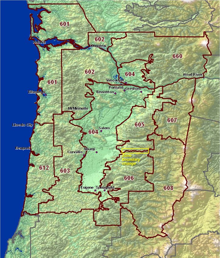
The boundary between fire weather zones 605 and 606 has been adjust south by roughly 10
miles (shown on attached map) in response to customer input.
LOCATION
National Weather Service Forecast Office
5241 NE 122nd Avenue
Portland, OR 97230-1089
HOURS
The National Weather Service Office is open 24 hours a day, 7 days a week. The fire weather
duty desk will be staffed with a CERTIFIED fire weather forecaster between the hours of 0600
and 1600 seven days a week during fire season, normally from Memorial Day through mid-
October. The fire weather desk is staffed with a CERTIFIED fire weather forecaster from 0700
to 1500 Monday through Friday during Spring burning (mid to late March through Memorial
Day), and also during the fall burning period (mid-October through early November).
STAFF
Steve Todd Meteorologist in Charge
Tyree Wilde Warning Coordination Meteorologist
Scott Weishaar Fire Weather Program Leader and IMET
Julia Ruthford Fire Weather Program Leader and IMET
Clinton Rockey Fire Weather Forecaster
Chris Collins Back-up Fire Weather Forecaster
Shawn Weagle Lead Forecaster and Fire Weather Forecaster
Jonathan Wolfe Back-up Fire Weather Forecaster
Kevin Donofrio Back-up Fire Weather Forecaster
Treena Hartley Lead Forecaster and Back-up Fire Weather Forecaster
CONTACT
Internet: http://www.wrh.noaa.gov/firewx/?wfo=pqr
Email
scott.weishaar@noaa.gov
julia.ruthford@noaa.gov
23FORECAST DISTRICT
Portland services fire weather zones 601-608, 612, and 660. This area covers:
Northwest Oregon and Southwest Washington, North Oregon Cascades including the Columbia
River Gorge (to about Hood River). South Washington Cascades and adjacent lowlands of Clark
County. The Portland Office is also responsible for spot forecasts in the east districts of the Mt.
Hood National Forest (Barlow District).
See the attached map for a graphic description of individual areas/zones of the Portland district.
AGENCIES SERVED
U.S. Forest Service (USFS)
U.S. Bureau of Land Management (BLM)
Oregon Department of Forestry (ODF)
Washington Department of Natural Resources (WDNR)
Various urban and rural local fire districts
FORECAST SERVICES
1. FIRE WEATHER GRIDS
Fire Weather grids from the Portland Fire Weather Office can be found at:
http://www.weather.gov/forecasts/wfo/sectors/pqrFireDay.php
2. RED FLAG WARNING/FIRE WEATHER WATCH
Fuels must be critically dry and fire danger moderate to high before a Red Flag Warning or Fire
Weather Watch is issued from the Portland office. Evaluations of fuel conditions will be made
in accordance with current NFDRS values and in consultation with fire managers. Assuming
these conditions are met, Fire Weather Watches and Red Flag Warnings are issued for the
following events:
A. COMBINATION OF STRONG WIND AND LOW HUMIDITY
Daytime: RH 25% or less AND 10-minute wind speed 10 mph or more for 4 hours.
Night: RH 35% or less AND 10-minute wind speed of 15 mph or more for 3 hours.
24B. DRY AND UNSTABLE AIR MASS
Mid and/or High level Haines 6, RH 25% or less, AND critical fuel conditions.
C. LIGHTNING
Scattered thunderstorm coverage, critical fuels AND no appreciable change in fuel
conditions after the event.
RED FLAG VERIFICATION
Red Flag warnings will be verified using the following criteria:
A. COMBINATION OF STRONG WIND AND LOW HUMIDITY
NIGHTTIME CRITERIA:
ZONES 601 AND 602: Two stations (RAWS) must report 35% humidity or less AND
10-minute wind speed of 10 mph or more for three hours in an 8-hour time block. Key
RAWS: Cedar Creek, Rockhouse1, and South Fork.
ZONES 603 AND 612: Rockhouse1 RAWS reporting 35% humidity or less AND 10-
minute wind speed of 15 mph or more for four hours in an 8-hour block AND one other
RAWS reporting 35% humidity or less AND 10-minute wind speed of 10 mph or more
for two hours. Key RAWS: Rockhouse1, Goodwin Peak, High Point, and Cannibal
Mountain.
ZONE 604: Two stations (airports) must report 30% humidity or less AND 2-minute
wind speed of 15 mph or more for at least four hours in an 8-hour block. Typically
occurs in the north part of the valley. Key STATIONS: Troutdale, Portland, Vancouver,
and Hillsboro.
ZONES 605, 607, AND 660: One station (RAWS) must report 35% humidity or less
AND 10-minute wind speed of 10 mph or more for four hours in an 8-hour block, AND
at least TWO other stations reporting 35% humidity or less AND 10-minute wind of 10
mph for at least TWO hours. Key RAWS: Horse Creek, Log Creek, Wanderer’s Peak,
Kosmos, Canyon Creek, Orr Creek, Elk Rock, and 3-Corner Rock. NOTE: Includes
stations from zone 659.
ZONES 606 AND 608: One station (RAWS) must report 30% humidity or less AND
10-minute wind speed of 10 mph or more for at least four hours in an 8-hour block, AND
ONE other station must report the same conditions for at least ONE hour. Key RAWS:
Brush Creek, Trout Creek, Yellowstone, and Emigrant.
25DAYTIME CRITERIA (ALL ZONES):
At least two stations within a zone must report 25% humidity or less AND wind-speed of
10 mph or more (except 15 mph in zone 604) for at least four hours in an 8-hour block.
Typically for east wind (offshore flow), but can occur in the Coast Range and
central/south Willamette Valley with north to northeast wind. Can also occur in the
Central Cascades and foothills with shallow marine surges (west to northwest wind).
B. CRITICALLY DRY AND UNSTABLE AIR MASS (HAINES INDEX 6)
At least ONE station within a zone must report 25% humidity or less, measure a mid
and/or high-level Haines 6, or exhibit inferred mid and/or high-level Haines 6
characteristics, AND fuel conditions (Dryness Levels) are in the “BROWN”, or
“YELLOW” under extreme or unusual conditions.
C. LIGHTNING IN COMBINATION WITH DRY FUELS
“Dry thunderstorm” Red Flag criteria is defined as follows: Abundant lightning in
conjunction with sufficiently dry fuels.
Abundant Lightning:
1) Number of lightning strikes that meet climatologically significant
criteria, or
2) Areal coverage of lightning such as “Scattered” or > 25%
Sufficiently Dry Fuels:
1) GACC dryness levels remaining out of the ‘green’ category on the day
of and the day following a thunderstorm event, or
2) ERC or BI values meeting climatologically significant percentiles, or
3) Land management declaration
This is a very rare event which, climatologically, has the highest likelihood of occurrence
in the south half of the Willamette N.F..
Dryness Levels SHOULD be in the “BROWN”, and expected lightning frequency is
such that multiple starts (5-7) are expected. (Typically “scattered” thunderstorm
coverage). Under unusual or extreme conditions, a Red Flag Warning can also be issued
when the Dryness Level is ”YELLOW”. Basically, “scattered” thunderstorms that do not
produce enough precipitation to appreciably change the Dryness Levels (from
“BROWN” or high “YELLOW”).
263. SPOT FORECASTS
Detailed weather information beyond what is presented in the general forecast may be obtained
with a spot forecast request. Spot forecasts may be requested by a telephone call to the fire
weather forecaster or through the spot forecast request web page available on the Portland fire
weather web page at:
http://spot.nws.noaa.gov/cgi-bin/spot/spotmon?site=pqr
4. GENERAL FORECASTS
Fire Season: Regularly scheduled general fire weather forecasts are issued twice per day by
certified fire weather forecasters at 0900 and 1445.
Prescribed Burning Season: Regularly scheduled land management forecasts are issued by
certified fire weather forecasters Monday through Friday at 0900 and 1430.
The Portland office will include wind gusts when the 10-minute wind speed is 10 mph or greater.
“Dryness Levels” (as developed by the Northwest Coordination Center) for the NWS Portland
forecast district will be included in the morning forecast. Refer to the NWCC Predictive
Services web site for more information. www.nwccweb.us
5. NFDRS TREND FORECASTS
Numerical point forecasts for NFDRS stations are prepared and disseminated to WIMS by 1545
each afternoon from April through early October. The point forecasts are used to compute the
expected NFDRS indices valid the following day. The number of NFDRS point forecasts made
by the weather office depends only on the number of NFDRS observations input into WIMS by
the fire agencies. If observations are not entered into WIMS by 1500 however, a forecast will
not be produced for that station.
TELEPHONE BRIEFINGS
Daily internet conference call: Portland fire weather conducts a daily weather briefing at 0940
PDT via a conference call from about early June through early October. Fire weather users are
encouraged to participate. The forecaster hosting the briefing will verbally highlight current and
forecast fire weather conditions with the help of an internet web page. Conference call
participants can follow along with the discussion while viewing graphics displayed on the web
page. Conference telephone numbers (and passcodes) can be obtained by contacting the Portland
weather office. The URL for the briefing graphics is: http://www.wrh.noaa.gov/pqr/fwb.php.
Graphics will be available by 0700 PDT.
27Unscheduled telephone briefings: Verbal weather briefings can also be obtained at any time.
A certified fire weather forecaster should be requested to conduct the briefing during fire weather
hours. Otherwise, a briefing will be available from the general forecast staff.
INCIDENT METEOROLOGIST SERVICES
Portland has two certified Incident Meteorologists (IMETs) on staff available for wildfire,
HAZMAT, or other emergency dispatches. To request an IMET, contact the appropriate fire
agency dispatch office.
OTHER SERVICES
FIRE WEATHER TRAINING AND LECTURES
An experienced fire weather forecaster will be available to help instruct the weather sections of
standard fire behavior training courses offered by federal, state and local government fire
agencies. This includes S-190 through S-590 and other courses. In addition, a forecaster will
also be available for special speaking engagements. For scheduling purposes, requests for an
instructor or speaker should be made at least three weeks in advance.
To request an instructor contact Julia Ruthford at Portland NWS Forecast Office at (503) 326-
2420 or by email at julia.ruthford@noaa.gov.
NORTHWEST GACC SUMMER DETAIL
The Portland office will detail an experienced fire weather forecaster to the Northwest
Geographic Coordination Center (GACC) for 40 hours each week March through October.
Duties will include publication of the regional fire weather operating plan, keeping GACC staff
continuously advised of fire weather conditions and conducting daily “blast-up” weather
coordination calls. Duties also include participation in case studies, fire weather and research
projects under the direction of the NWCC fire weather program manager.
28Portland Fire Weather Zones
29GEOGRAPHIC ZONE DESCRIPTIONS
Zone 601 – North Oregon and South Washington Coast including Willapa Hills
Represents the South Washington and North Oregon coastal strip including adjacent west slopes
of the Oregon Coast Range and the Willapa Hills of Washington. This zone includes the north
portion of the Siuslaw N.F., ODF, and WA DNR protected private land.
Extends east-west from the crest of the Oregon Coast Range to the Pacific Ocean. Extends
north-south from the north boundary of Pacific County, WA to Oregon State Highway 22 along
the eastern boundary of ODF regulated use area NW-2. The Washington section of this zone
represents Pacific and Wahkiakum counties in their entirety.
Zone 612 – Central Oregon Coast
Represents the Central Oregon coastal strip including adjacent west slopes of the Oregon Coast
Range. Includes southern portions of the Siuslaw N.F. and ODF protected private land.
Extends east-west from the crest of the Oregon Coast Range to the Pacific Ocean. Extends
north-south from Oregon State Highway 22 to the Umpqua River along the west edge of the
Siuslaw National Forest including ODF regulated use area SL-2.
Zone 602 – North Coast Range
Represents the east slopes of the North Oregon and South Washington Coast Range. Mostly
private land under ODF and WA DNR protection.
Bounded on the west by Coast Range crest. Bounded on the east, in Oregon, by the west
periphery of the Willamette Valley and Columbia River. Bounded on the east, in Washington,
by the contour of the Willapa Hills/Coast Range. Extends north-south from the north boundary
of Lewis County, WA to Oregon State Highway 22.
Zone 603 – Central Oregon Coast Range
Represents the east slopes of the Central Oregon coast range. Mostly ODF protected private
land.
Bounded on the west by the Coast Range crest. Bounded on the east by the western periphery of
the Willamette Valley. The north boundary is along Oregon State Highway 22. The south
boundary lies along Oregon State Highway 38.
Zone 604 – Willamette Valley including Clark County Lowlands of Washington
Bounded on the west and east, in Oregon, by the foothills of the Coast Range and Cascades.
Bounded on the west and east, in Washington, by the Columbia River and South Washington
Cascade foothills. Extends north-south from Lewis County, WA to just south of Cottage Grove
Reservoir.
Zone 605 – North Oregon Cascade Foothills
Represents foothill elevations of the North Oregon Cascades. Mostly ODF protected private
land.
30You can also read