Northwest Fire Weather Operating Plan - Oregon Washington May 2017 - National Geographic Area ...
←
→
Page content transcription
If your browser does not render page correctly, please read the page content below
Northwest Fire Weather
Operating Plan

Oregon
Washington       May 2017

             1
This page intentionally left blank

                2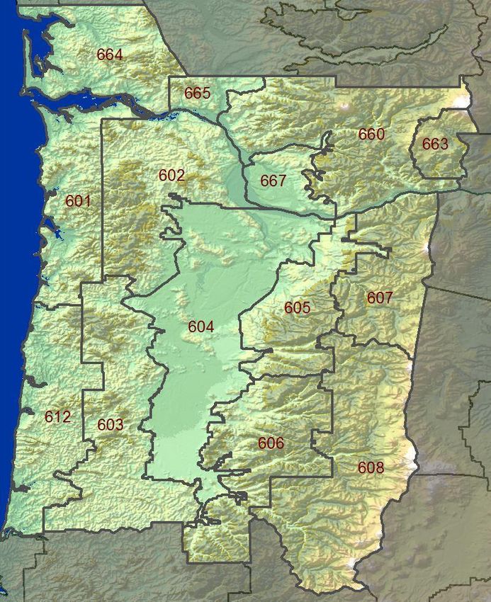
3
4
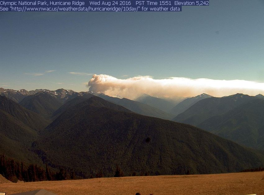
Table of Contents
Agency Signatures/Effective Dates of the AOP ………………………………………… 3

Chapter 1 – Administrative …………………………………………………………………. 5

 Introduction ………………………………………………………………………………….. 5
 NWS services and responsibilities……..………………………………………………….. 6
 Wildland fire agency services and responsibilities……………………………………… 10
 Joint responsibilities……………………..………………………………………………….11

Chapter 2 – Operating Plans ………..……………………………………………………. 13

 NWCC Predictive Services ....……………………………………………………………. 14
 NWS Boise ………….……………………………………………………………………… 20
 NWS Medford ...…….……………………………………………………………………… 24
 NWS Pendleton …….……………………………………………………………………… 32
 NWS Portland …..….……………………………………………………………………….43
 NWS Seattle ….…….……………………………………………………………………… 56
 NWS Spokane ..…….……………………………………………………………………… 68
 Oregon Department of Forestry Weather Center ………………………………………. 78
 Washington Department of Natural Resources Fire Danger Program .………………..81

Appendix A: Fire Weather Agreements and Documents ……………………………. 86

Appendix B: Forecast and Service Performance Measures…………………………. 87

Appendix C: Reimbursement for NWS-provided Training …………………………… 89

Appendix D: Meteorologist Position Description Form ………………………………. 90

Appendix E: IMET Billing Points of Contact……………………………………………. 91

Appendix F: HYSPLIT Request Instructions ……………………………….…………... 93

                                    5
Chapter 1
Administrative
INTRODUCTION

a. The Pacific Northwest Fire Weather Annual Operating Plan (AOP) constitutes an
   agreement between the Pacific Northwest Wildfire Coordinating Group (PNWCG),
   which is comprised of state, local government and Federal land management
   agencies charged with the protection of life, property and resources within the Pacific
   Northwest from threat of wildfire; and the National Weather Service (NWS), National
   Oceanic and Atmospheric Administration, U.S. Department of Commerce, charged
   with providing weather forecasts to the Nation for the protection of life and property.

  The AOP provides specific procedural and policy information for the delivery of fire
  weather information to the fire management community in the Pacific Northwest. It is
  the objective of the NWS and PNWCG to ensure that quality of service is maintained
  through a mutual analysis of services provided. The NWS and PNWCG work closely
  in all phases of the fire weather forecast and warning program to resolve concerns
  and avoid potential inconsistencies in products and services prior to delivery to fire
  agency customers. The goal of all agencies is to maximize firefighter and public
  safety through a coordinated delivery of consistent services.

  Fire weather services are a critical building block to fire management agencies in
  decision-making because human lives and valuable natural resources are at risk. It is
  the role of the NWS to provide fire weather services and products to fire managers. It
  is the role of the fire management agencies to analyze and interpret fire weather
  forecasts into fire danger and fire potential predictions when making decisions
  essential to the success of fire management actions.

  It is to the mutual advantage of PNWCG and NWS and in the public interest and for
  firefighter safety to coordinate efforts for weather services for fire management
  activities in the Pacific Northwest to minimize duplication of efforts and improve
  efficiency and effectiveness.

b. The general relationship between the NWS and the interagency fire management
   community is set forth in the following reference documents:

  Interagency Agreement for Meteorological Services Among the Bureau of Land
  Management, Bureau of Indian Affairs, U.S. Fish and Wildlife Service, and National
  Park Service of the U.S. Dept. of Interior, the Forest Service of the U.S. Dept. of
  Agriculture, and the National Weather Service of the U.S. Dept. of Commerce
  (National MOA or National Agreement);

  National Weather Service NWSI 10-4: Fire Weather Services;
                                            6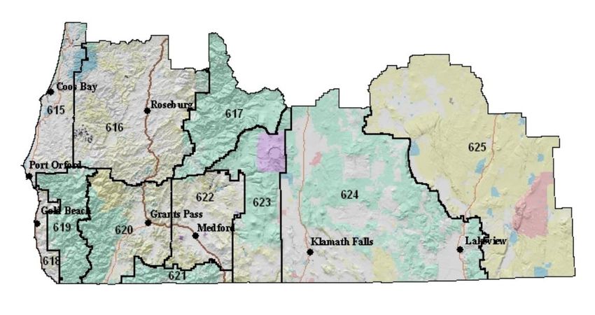
2016 National Mobilization Guide; and

  Pacific Northwest Mobilization Guide

c. The PNWCG is comprised of the following Federal and State fire agencies: State of
   Oregon, Department of Forestry; State of Washington, Department of Natural
   Resources; USDA Forest Service, Pacific Northwest Region; USDI, National Park
   Service, Pacific West Region; USDI, Fish and Wildlife Service, Pacific Region; USDI,
   Bureau of Indian Affairs, Portland Area Office; USDI, Bureau of Land Management,
   Oregon and Washington.

NWS SERVICES AND RESPONSIBILITIES

The National Weather Service will collaborate with the fire agencies when proposing
alterations to the fire weather program and services provided in the Pacific Northwest.
NWS-developed proposals are provided to PNWCG for review, assessment, and
comment prior to adoption and implementation. NWS considers any concerns
expressed by PNWCG, especially as related to performance integrity, in its assessment
of change proposals in the fire weather program and other services provided.

Fire Weather Services

  1. Core grids and web-based fire weather decision support
     National Digital Forecast Database (NDFD) grids are used to produce a wide
     variety of products and services for fire weather support. Operational status of
     NWS grid elements is available at the following website:

     http://www.weather.gov/ndfd/resources/NDFD_element_status.pdf

     NWS offices produce several web-based digital planning tools to assist fire
     weather customers. These include FARSITE weather input data, hourly weather
     graphs, point forecast matrices, activity planners, hourly weather graphs, and 48-
     hour element meteograms. Please contact your local servicing NWS office with
     any questions or for more information.

     NWS fire weather grids for the Pacific Northwest are graphically displayed at
     http://graphical.weather.gov/sectors/pacnorthwestFireDay.php#tabs.

  2. Fire weather watches and red flag warnings
     Fire weather watches and red flag warnings are issued when the combination of
     dry fuels and weather conditions support extreme fire danger and/or fire behavior.
     These statements alert land management agencies to the potential for widespread
     new ignitions which could overwhelm initial attack activities, or conditions which
     could cause control problems on existing fires, etc. Any of these outcomes could
     pose a threat to life and property.

                                            7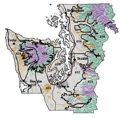
Fire Weather Watch: A fire weather watch is issued when there is a high potential
  for the development of a red flag event. A watch is issued 18 to 96 hours in
  advance of the expected onset of criteria. The watch may be issued for all, or
  selected portions within a fire weather zone or region. The overall intent of a fire
  weather watch is to alert forecast users at least a day in advance for the purposes
  of resource allocation and fire fighter safety.

  Red Flag Warning: A red flag Warning is used to warn of impending or occurring
  red flag conditions. Its issuance denotes a high degree of confidence that weather
  and fuel conditions consistent with local red flag event criteria will occur in 48
  hours or less. Longer lead times are allowed when confidence is very high or the
  fire danger situation is critical. Forecasters can issue a warning for all or selected
  portions within a fire weather zone.

  Prior to issuance, all red flag warnings are coordinated with affected agencies and
  neighboring fire weather offices, in order to assess fuel conditions and general fire
  danger. Each issuance, update or cancellation of a fire weather watch or red flag
  warning is also relayed by telephone to the dispatch office(s) affected by the
  watch/warning. Red flag warnings and fire weather watches will be issued using a
  bulleted format.

3. Spot forecasts
   Spot forecasts are site specific forecasts issued by the NWS in support of wildfire
   suppression and natural resource management. Spot forecasts may also be
   issued for hazardous materials incidents, search and rescue missions and other
   threats to public and responder safety. All spot forecast requests should be
   accompanied by a representative on-site weather observation.

  Issuance Criteria: Spot forecasts are non-routine products issued at the request of
  the user. WFOs will provide spot forecast service upon request of any federal,
  state, tribal, or local official who represents the spot forecast is required to support
  a wildfire.

  For non-wildfire purposes, resources permitting, WFOs will provide spot forecast
  service under the circumstances and conditions outlined in NWS Instruction 10-
  401. Spot forecasts will not be provided to private citizens or commercial entities
  not acting as an agent of a government agency.

  Requesting a Spot Forecast: Spot forecast requests are normally made via the
  Internet through local NWS fire weather pages. When web access is not available,
  spot forecasts may be requested and disseminated via fax - using the spot
  forecast request form D-1 (NWSI-401) in Appendix E. An electronic fillable pdf
  version of WS form D-1 can be found at: 6
  http://www.srh.noaa.gov/ridge2/fire/docs/WS_FORM_D_SPOT.pdf

                                           8
The requestor must provide information about the location (latitude/longitude),
slope aspect, drainage name, fuel type(s), top and bottom elevations of fire or
project, size of fire or project, ignition time, and contact names and telephone
numbers of the responsible land management personnel. It is critically important
that each spot forecast request also include quality, representative
observations at, or near, the site. A detailed description of the observation
location relative to the project (if not at the site) should be provided. The
description should include, at a minimum, distance and direction from the
project or fire site, station elevation and aspect.

An exception to the rule regarding on-site weather observations is as follows: a
spot forecast request can be made without an observation if it is on an initial attack
fire of less than two hours, there are red flag warnings or fire weather watches in
effect, or the available fire weather forecasts is not representative of what is
observed at the site. Even in this situation, a representative observation will result
in a better forecast.

Fire agencies are strongly encouraged to call the WFO after submitting a spot
request to ensure it was received properly. The WFO will attempt to notify field
personnel and/or the dispatch office whenever there is a significant change in the
expected weather.

For detailed instructions submitting a Spot Forecast Request, go to:
http://www.wrh.noaa.gov/sew/NW_SpotRequestInstructions.pdf

Updates to Spot Forecasts: Spot forecasts are considered one-time requests, and
are not routinely updated. Spot forecasts may be updated when new
representative observations are available to the forecaster or if the forecaster
deems the current forecast does not adequately represent current or expected
weather conditions. Land or emergency management personnel are encouraged
to contact the appropriate WFO for a spot update if forecast conditions appear
unrepresentative of the actual weather conditions. The spot forecast will be
corrected when a typographical or format error is detected that could confuse the
intended meaning. Updated and corrected spot forecasts will be delivered to users
in the same manner as the original spot forecast when possible.

Spot Forecast Feedback: Good communication between fire managers and the
NWS is critical for quality spot forecast services. Land management personnel
should provide feedback to the NWS forecasters about the quality and accuracy of
the spot forecast. Responsibility for providing fire line observations for the
verification of forecast accuracy rests with the land management agencies. Onsite
observations taken during the operational period the forecast is valid for are to be
provided back to the WFO via the feedback box online spot forecast form, or by
phone, fax or e-mail.

                                       9
Hysplit Trajectory Output: Hysplit trajectory output is available when requesting a
  Spot Forecast. See Appendix F for details.

4. Fire weather planning forecasts
   The Fire weather planning forecast is a zone-type product used by land
   management personnel primarily for input in decision-making related to pre-
   suppression and other planning. The decisions impact firefighter safety, protection
   of the public and 7 property, and resource allocation. Weather parameters
   represent average conditions across the given zone.

  Headlines are included in the fire weather planning forecast (FWF) whenever a red
  flag warning or fire weather watch is in effect or to highlight other critical weather
  information. A brief, clear, non-technical discussion of weather patterns that will
  influence the forecast area will begin the forecast with the emphasis on the first
  two days of the forecast period. A discussion of latter periods will be included if
  significant weather is expected to impact safety or operations. Sky and weather,
  maximum and minimum temperature and relative humidity, wind speed and
  direction, Haines index, lightning activity level and chance of wetting rain are
  included in the FWF by all of the WFOs in the Pacific Northwest. Several offices
  also forecast mixing height and transport winds.

  Two forecasts will be issued daily during fire season – a morning forecast between
  5 AM and 9 AM and an afternoon forecast around 3 PM. Once-a-day forecasts will
  continue through the spring and fall burning seasons at the request of the land
  managers with some offices continuing land management forecasts through the
  winter. Local start and stop dates shall be coordinated between the NWS offices
  and fire weather customers, including the geographic area Predictive Services
  Units.

5. NFDRS forecasts
   The National Weather Service role in NFDRS is providing weather forecast input,
   which combined with fire agency input, allows the NFDRS software in WIMS to
   predict the next day's fire danger indices. These indices impact agency resource
   management decisions, firefighter safety, and protection of the public and
   property.

  Numerical point forecasts for NFDRS stations are prepared and disseminated to
  WIMS by 1540 each afternoon from April or May through early October. The point
  forecasts are used to compute the expected NFDRS indices valid the following
  day. The number of NFDRS point forecasts made by the weather office depends
  only on the number of NFDRS observations input into WIMS by the fire agencies.
  If observations are not entered into WIMS by 1500 however, a forecast may not be
  produced for those stations. A weather forecaster may also not produce a forecast
  for sites with highly questionable observations.

6. Phone briefings

                                         10
All Pacific Northwest NWS Offices provide daily fire weather phone briefings each
morning during fire season. Local Fire weather users are encouraged to participate
in these briefings. The forecaster hosting the briefing will verbally highlight current
and forecast fire weather conditions with the help of weather graphics on an
internet web page or through a GoToMeeting® webinar. Briefing times, conference
call telephone numbers and passcodes can be obtained by contacting the local
WFO. A link to the web briefings can be found on the local fire weather page.
7. Forecast verification
Routine verification is made on Red Flag Warnings and NFDRS forecasts. Results
of the verification will be published in the Fire Weather Annual Summary. Spot
forecast turnaround time and other statistics are available from your local NWS
office.
8. Incident Meteorologist services
Each WFO in the Pacific Northwest has 2 or more Incident Meteorologists (IMETs)
on staff available for wildfire, HAZMAT, Search and Rescue or other emergency
dispatches. To request an IMET, contact the appropriate fire agency dispatch
office.
9. Social media
Each NWS office in the Pacific Northwest has a Facebook page, Twitter account,
and a YouTube channel. Current information about Fire Weather may be included
in social media feeds as time allows, but such information is intended as
supplemental information for the general public; NWS use of social media is not
intended to meet the specialized needs of the wildland firefighting community.
10. Non-forecast services
Several duties fall into the non-forecast services including, but not limited to:
teaching assignments, customer meetings, customer consultations, preparation of
annual reports, preparation of annual operating plans, program management,
research and in-house training of personnel. Experienced Fire Weather
Forecasters will be available to help instruct the weather sections of standard fire
behavior training courses offered by federal, state and local government fire
agencies. These include S-190 through S-590 and other courses. In addition, a
forecaster will be available for special speaking engagements and customer
consultations. For scheduling purposes, requests for an instructor or speaker
should be made at least three weeks in advance. Requests for NWS personnel to
provide training should be accompanied by a separate reimbursement or advance
of funds Agreement, if overnight travel is necessary. Every effort should be made
to acquire invitational travel orders for the NWS resource, provided by the
requesting Agency. Additional information can be found in the National Fire
Weather Annual Operating Plan: http://www.weather.gov/fire under the Admin tab,
or in Appendix C.
WILDLAND FIRE AGENCY SERVICES AND RESPONSIBILITIES
11Provide coordination and recommendations for interagency fire weather activities in
Oregon and Washington through the PNWCG. Continually review standards of
performance for applicability and adequacy.
Provide weather observations seven days a week during fire season and coordinate
and cooperate with the NWS in fire weather forecasting. The agencies will seek the
advice and counsel of the NWS regarding observational issues (e.g. moving remote
automatic weather stations).
Recognize that other severe weather emergencies may require the services of the fire
weather forecaster to assist in WFO operations.
1. User agency responsibilities:
There are several responsibilities of the user agencies including:
• Entering of 1300 LST NFDRS observations in WIMS
• Site observations for Spot Forecast requests
• Quality Control of RAWS observations
• Timely maintenance of RAWS sites
JOINT RESPONSIBILITIES
Work cooperatively as partners to maintain and improve fire weather services to assure
full compliance with mutually established performance, reliability, priority, and time
standards.
Recognize that lands for which the States are responsible for wildland fire protection in
Oregon and Washington, and the lands for which the respective Federal Agencies are
responsible, are intermingled or adjacent in some areas, and wildland fires on these
intermingled or adjacent lands may present a threat to the lands of the other. Recognize
the primary role of the States in administering smoke management plans in their
respective states.
Prepare an Annual Operating Plan (AOP – this document) that includes each WFO with
fire weather areas of responsibility in Oregon and Washington as required in the
National Fire Weather Agreement and fire and smoke management responsibilities (as
appropriate) of DNR, ODF and NWCC Predictive Services. Fire weather zone and
Predictive Service Area maps will be included in the AOP. The AOP will meet the
guidelines specified in NWSI 10- 404.
Annually review the performance of the NWS and NWCC Predictive Services in meeting
the needs of the fire management community. This review will be used to help
determine what program adjustments are needed and appropriate. PNWCG directed
subject matter experts (SMEs) and the NWS MICs from Boise, Medford, Pendleton,
Portland, Seattle and Spokane shall conduct the review. NWCC Predictive Service, the
12NWS, PNWCG SMEs and any interested members of the fire community shall meet
annually around February. The meeting will evaluate the past season fire weather
services and recommend changes for the next fire season. Proposed changes in fire
weather services for the upcoming fire weather season will be discussed and if agreed
upon reflected in the AOP. AOP sections from individual offices are expected to be
finalized no later than April 1st (drafts are requested the February meeting) so that the
compiled Pacific Northwest AOP can be submitted to the PNWCG and NWS signatories
for final approval. Changes after April 1st should, if at all possible, be held off until after
fire season. If extenuating circumstances require significant additional changes to be
made for the current fire season, the AOP will need to be reapproved by the signing
officials.
Respond to the other party's proposals within thirty (30) days, or advise the other party
when the proposal will be addressed if the NWS or the PNWCG are unable to meet or
discuss the proposal within their respective groups in that time frame. Except when
necessary to meet emergency needs, significant proposals are expected to be
discussed at the annual meetings.
Cooperate and coordinate plans for the weather-related training of fire personnel and
fire weather forecasters to ensure that training needs are met.
Collaborate in fire weather research and development.
13Chapter 2
Operating Plans
The Hayes Fire as seen from Hurricane Ridge during an east wind event. August 24, 2016.
14NWCC PREDICTIVE SERVICES
MISSION
The Predictive Services Program supports the wildland fire community and incident
coordination system with decision support information. This typically includes a
synthesis of fire danger, fire weather, fire intelligence, and fire management resource
information. Information generated by NWCC typically revolves around decision support
information for determining regional preparedness level and distribution of fire
management resources.
GOALS AND RESPONSIBILITIES
Predictive Services provides decision support and tools which enable proactive, safe
and cost effective fire management. Predictive services actively partners with state and
federal wildland fire agencies, cooperating agencies, research, academia, and the
private sector to ensure the relevance of predictive services’ products and program.
LOCATION
Northwest Interagency Coordination Center
150 SW Harrison St. Suite 400
Portland, OR 97201
OPERATING HOURS
FIRE SEASON (mid-June through early October)
0700-1700 PDT 7 days a week
NON FIRE SEASON
0700-1530 PDT 5 days a week
STAFF AND CONTACT
The NWCC Predictive Services program is interagency. It encompasses two
meteorologists, a Fire Management Analyst and assistants, an Intelligence Officer and a
Geographic Information System (GIS) specialist and assistants from the different federal
and state land management agencies.
METEOROLOGY
John Saltenberger Program Manager
Vacant
15Various Detailers during fire season
INTELLIGENCE/FIRE MANAGEMENT
Mike Powell Fire Management Analyst
Vacant Intelligence Officer
Various Detailers during fire season
GIS
Barbra Haney GIS specialist
Various detailers during fire season
WORLD WIDE WEB
http://gacc.nifc.gov/nwcc/
EMAIL
jsaltenb@blm.gov
mike_r_powell@nps.gov
bhaney@blm.gov
FORECAST AREA
Washington and Oregon, statewide. Forecast zones are divided into Predictive Service
Areas (PSAs), which are defined at the end of this plan.
FIRE WEATHER SERVICES
Predictive Services provides national and geographic area specific products primarily
designed to meet regional and national interagency needs such as GACC coordinators,
Multi-Agency Coordination groups, NWS forecasters, incidents, and to a lesser extent,
local fire management users. Predictive Services analyzes situational information, fuels
conditions and fire danger, fire weather, and ignition data in order to produce and
disseminate fire potential decision support products. These products are produced so
that fire managers can make pro-active fire management decisions
Daily Fire Activity Forecast: Updated daily, the Fire Activity Forecast summarizes
anticipated fire load over the next five days by projecting:
the number of new ignitions expected in each PSA
the probability of new significant fires in each PSA
7-Day Significant Fire Potential: The 7-Day Significant Fire Potential product
combines fire weather, fire danger, ignition potential, and resource status information
into a projection of significant fire potential for the next week. “Significant fires” are
defined in the NWCG glossary as those fires large and costly enough to warrant
movement of firefighting resources from outside the area where the fire originates.
PSAs undergoing maximum foreseeable risk of a significant wildland fire event are
denoted in red or orange “high risk” symbol depending on the contributing factors
mentioned above. PSAs highlighted in red are at risk of new significant fires due to a
16large number of new ignitions. PSAs highlighted in orange are at risk due to the severity
of the burn environment (such as strong winds or instability combined with high fire
danger).
The daily 7-Day Significant Fire Potential product is available at:
Northwest: http://gacc.nifc.gov/nwcc/content/products/fwx/guidance/dl.pdf
National: http://psgeodata.fs.fed.us/forecast/#/outlooks?state=map
The Fire Activity Forecast and 7-Day Significant Fire Potential products were developed
using objective data sources such as the FPA fires database, Fire Family Plus, and
detailed meteorological data on grid domain centered over the Pacific Northwest. Over
a decade’s worth of data were gathered and compared to identify patterns of weather,
ignitions, and fire danger that combine to boost the risk of large fire events.
Environmental elements that were commonly identified as consistent contributors for
initiation of significant fires in various PSAs include:
Absolute values and fluctuations in fire danger
o Energy Release Component
o 100-hr dead fuel moisture
General winds across the landscape
Instability in the middle atmosphere
Dryness in the atmosphere
o Vapor pressure deficit
Sufficient numbers of ignitions concentrated in a 24hour period.
o Lightning
o Human
Note: The 7-Day Significant Fire Potential Forecast is not intended to be interpreted as
a fire weather forecast or a fire behavior forecast. It is not intended to be used for
firefighter or public safety. It does not necessarily reflect extreme conditions. Rather, it
simply depicts the daily risk of fires growing to meet the ‘significant’ size criteria in each
PSA based on historical combinations of past contributing factors.
Regional Preparedness Level Forecast: Daily Preparedness Level for the Northwest
geographic area is determined by the NWCC center manager and/or Operations
Manager with guidance from the NWCC Predictive Services unit.
That guidance is based on objective assessment of the current demand and forecasts
for future need of fire management resources from NWCC’s Fire Activity Forecast.
Analysis of historical usage of fire management resources since 2004 was blended with
numbers of reported ignitions and resulting large fires to model resource demand when
similar conditions repeat themselves in the future.
The daily Preparedness Level Forecast is available at: http://gacc.nifc.gov/nwcc/brief
17Monthly and Seasonal Significant Fire Potential Outlooks: The Monthly and
Seasonal significant Fire Potential outlook identifies geographic regions across the US
likely to expect above average, average, or below average significant fire load during
the next month and through the following three months. Significant fires are defined as
those severe enough to require mobilization of firefighting resources from outside the
area the fire originates.
http://gacc.nifc.gov/nwcc/content/products/fwx/MonthlySeasonal.pdf
http://gacc.nifc.gov/nwcc/content/products/fwx/MonthlySeasonal.ppt
A narrated audio/video webcast of the Monthly and Seasonal Significant Fire Potential
outlook is routinely updated at:
http://gacc.nifc.gov/nwcc/content/videos/Monthly_Seasonal.mp4
Monthly and Seasonal outlooks (maps and narratives) for the entire US are at:
http://www.predictiveservices.nifc.gov/outlooks/outlooks.htm
Fire Behavior and Fuels Advisories: When fire behavior is known or anticipated to be
severe over a large section of the Geographic Area Predictive Services assists in the
issuance of any fuels/fire behavior advisories. Fire Behavior and Fuels advisories can
be seen at:
https://www.predictiveservices.nifc.gov/fuels_firedanger/Fuels_FireBehavior_Advisories.
png
Fuels and Fire Danger Information: Links to fuels and fire danger related information
used to evaluate fire potential are located here.
https://gacc.nifc.gov/nwcc/predict/fire_fuel.apsx
Intelligence reports: During fire season NWCC’s Predictive Services intel unit
publishes regular updates of fire activity, resource status, situation reports, and large
fire maps at:
http://gacc.nifc.gov/nwcc/predict/intelligence.aspx
GIS: NWCC’s Predictive Services Geographic Information Systems unit gathers,
decodes archives, and plots a plethora of fire and weather information daily during fire
season. This includes:
Active fire mapping and fire perimeters in Google Earth
NFDRS summary maps
Daily lightning strikes
Daily rainfall total maps
Further documentation of NWCC’s GIS unit can be accessed at:
https://gacc.nifc.gov/nwcc/predict/gis.aspx
18NWCC Predictive Services Fire Danger Rating Operating Plan and Supporting
Documentation: A detailed explanation of NWCC Predictive Services’ fire potential
system is at:
https://gacc.nifc.gov/nwcc/content/products/fwx/fdrop/FDROP.pdf
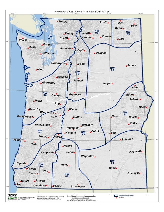
PREDICTIVE SERVICE AREAS (PSAs)
Twelve Predictive Service Areas (PSAs) were designated from a climatological study of
daily relative humidity fluctuations over a period of more than a decade. Within each
PSA “key” NFDRS sites have been selected to contribute to daily evaluations of fire
danger averaged across each PSA. All key stations are given equal weighting as an
NFDRS “sig” group. ‘Key’ NFDRS sites were determined by an objective study that
compared stations and identified redundancy.
19Most of NWCC’s Predictive Service fire potential products are based on these PSAs.
Note that PSAs do not correspond to fire dispatch area perimeters, agency ownership,
or political boundaries. They simply reflect large scale daily weather and fire danger
fluctuations.
20NATIONAL WEATHER SERVICE
BOISE
WHAT’S NEW
New SPOT page is operational nationwide. Please see the NWS Boise Fire
Weather web page for training videos. They are located here.
HOURS OF OPERATION
Once-a-day issuance of the Planning Forecast (FWF) will begin early-to-mid May, but
will be dependent on ongoing weather and fuel conditions. These forecasts will be
issued Monday through Friday by 0730 PDT (0830 MDT).
Starting dates for the full complement of fire weather products, including NFDRS
Forecasts and twice-daily Planning Forecasts, will depend on variables such as fuel
dryness and customer needs. This typically occurs in late May or early June.
Staff meteorologists are available anytime; 24 hours a day, 7 days a week. The fire
weather desk is staffed from 0630 to 1430 PDT (0730 to 1530 MDT).
LOCATION
Boise Weather Forecast Office
NIFC – National Weather Service
3833 S. Development Ave., Bldg. 3807
Boise, ID 83705-5354
STAFF AND CONTACT INFORMATION
Chuck Redman Fire Weather Program Leader/IMET
Chuck.Redman@noaa.gov
Megan Thimmesch Fire Weather Program Leader /IMET
Megan.Thimmesch@noaa.gov
Michael Cantin Meteorologist-in-Charge
Michael.Cantin@noaa.gov
Phone:
Fire Weather Webpage: http://www.wrh.noaa.gov/firewx/?wfo=boi
Facebook Page: https://www.facebook.com/US.NationalWeatherService.Boise.gov
Twitter Page: https://twitter.com/NWSBoise
Twitter Handle: @NWSBoise
21FORECAST AREA
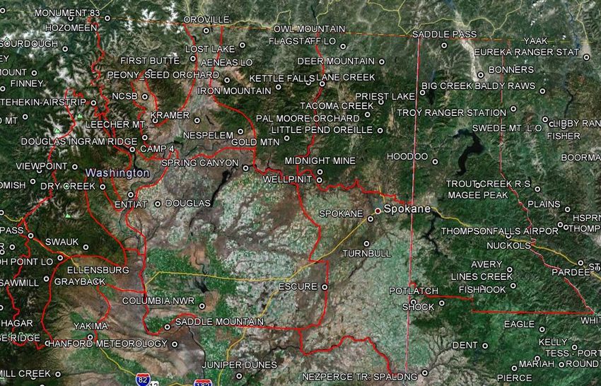
Fire weather zones OR636, OR637, and OR646, all located in Oregon. See map below:
Map of the Boise Fire Weather District within the NWCC, OR636, OR637, & OR646.
FIRE WEATHER SERVICES
Product Schedule
Product: Issuance time: (MDT) / (PDT)
22Morning planning forecast 0830 / 0730
Internet briefing 0930 / 0830
Afternoon planning forecast 1530 / 1430
NFDRS point forecast 1530 / 1430
Fire Weather Watch / Red Flag Warnings Event Driven
Spot forecasts Upon Request
Red Flag Events: High to extreme fire danger and dry fuels (defined by agency input), in
combination with the following weather conditions:
Areal thunderstorm coverage of scattered or greater (>25%), implying LAL of 4 or
greater (see below).
High Haines index of 6 in combination with RH35 mph,
combined with relative humidity 10% or less, are considered Red Flag Criteria.
Red Flag Criteria are considered to be met if conditions are observed at any
three RAWS stations within a combined area of Fire Weather Zone 636 and 637
for >3 hours (not necessarily consecutive). Alternatively, if a RFW is issued
separately for Fire Weather Zones 636 and 637, it is considered to verify if
conditions are met at three RAWS stations in Zone 636 or two RAWS stations in
Zone 637 and 646.
SUSTAINED 20 FT WIND (10-MINUTE AVERAGE in MPH)
10 mph 15 mph 20 mph 25 mph 30 mph
20% W
15% W W
10% W W W
Lightning Activity Level: The chart listed below will be used to forecast Lightning
Activity Level (LAL):
LAL = 1 No Thunderstorms
LAL = 2 Isolated Thunderstorms
LAL = 3 Isolated Thunderstorms (Increased Confidence/Threat)
LAL = 4 Scattered Thunderstorms
LAL = 5 Numerous Thunderstorms
LAL = 6 Scattered (But Exclusively Dry) Thunderstorms
Interagency Coordination: Before the issuance of a Fire Weather Watch or Red Flag
Warning, there will be coordination with the affected agencies and neighboring NWS
Forecast Offices in order to assess fuel conditions and general fire danger.
23Dissemination of Fire Weather Watches and Red Flag Warnings: Each issuance,
update, or cancellation of a Fire Weather Watch or Red Flag Warning will be relayed by
telephone to the dispatch office(s) affected by the Watch/Warning.
Spot Forecasts: Please reference LAT/LON when requesting spot forecasts. Follow-up
phone calls are always encouraged and feedback is extremely useful.
Weather Briefings: A daily briefing will be conducted each day at 0930 MDT (0830 PDT)
for all agencies via a GoToMeeting. If there is not sufficient interest in a daily briefing
during pre-fire season and low fire-activity periods, it will be held only on Mondays and
Thursdays.
The briefing will include a general discussion of weather conditions and forecasts for the
current day, as well a brief discussion of the extended period. Model data, satellite loops,
and other items of interest will be addressed for the forecast period. The briefing will
usually be about 10-15 minutes, but may be longer during active fire periods.
24NATIONAL WEATHER SERVICE
MEDFORD
WHAT’S NEW
Wording in “Staff” section was adjusted for accuracy and for change of IMET
Wording in “Forecast Services” section was updated. Services have been parsed
out for clarity and links have been updated, to include the link for the new Spot
Weather Request page.
More information was added regarding the Daily Fire Weather Briefing.
HOURS OF OPERATION
24 hours a day, year round. Meteorologists are on duty 24 hours a day, 7 days a week.
Additional forecasters will be brought in to staff for severe weather, to include that
related to wildfire. Under the provisions of the National Fire Weather Agreement, special
service provided by the Medford office will be done on a reimbursable basis.
LOCATION
National Weather Service Medford
4003 Cirrus Drive
Medford, Oregon 97504
STAFF AND CONTACT INFORMATION
The Medford office is staffed with 19 full-time meteorologists. 15 of these forecasters
participate in producing fire weather forecasts after each has completed the training,
which includes correspondence courses, computer-based Fire Weather Training
Modules, mesoscale analysis, climatological and terrain familiarization, and spot
forecast training.
Management staff:
John Lovegrove Meteorologist-in-Charge
Certified Fire Weather Forecaster staff:
Michael Stavish Science and Operations Officer
Ryan Sandler Warning and Coordination Meteorologist
Brett Lutz Meteorologist / Fire Weather Program Leader
Frederic Bunnag Senior Met. / Asst. Fire Program Leader/IMET
Sven Nelaimischkies Senior Met. / Marine Program Lead & Webmaster
Ken Sargeant Internet Technical Officer (ITO)
Jay Stockton Senior Meteorologist
Tom Wright Senior Meteorologist, IMET Trainee
25Connie Clarstrom Senior Meteorologist
Shad Keene Meteorologist
Mike Petrucelli Meteorologist / Aviation Program Leader
Marc Spilde Meteorologist
Dan Weygand Meteorologist
Brian Nieuwenhuis Meteorologist / Asst. Marine Program Leader
Bradley Schaff Meteorologist
Meteorologist Interns and Fire Weather Forecaster Trainees:
Misty Duncan Climate Program Leader
Michelle Cohen
Charles Smith
NWS Medford Homepage: http://www.wrh.noaa.gov/mfr
Facebook Page: https://www.facebook.com/NWSMedford?ref=ts
Twitter Page: https://twitter.com/NWSMedford
Twitter Handle: @NWSMedford
FORECAST AREA
Southern Oregon, fire weather zones 615, 616, 617, 618, 619, 620, 621, 622, 623, 624,
and 625.
FIRE WEATHER SERVICES
Fire Weather and Land Management Forecasts: The Land Management
Forecast/Fire Weather Planning Forecast is issued during the off-season, usually from
mid-October through early May. This forecast is available on the webpage once daily by
260700 local time. The frequency of the Land Management Forecast and the forecast
elements may be increased as the fire season approaches. The Fire Weather Program
Leader will inquire with the user agencies as weather and fuel conditions warrant during
the off season to determine as to when additional forecast elements and/or forecasts
are needed. During the fire season, the Fire Weather Forecasts will be issued twice
daily at 0700 and 1500 PDT.
ECCDA Forecasts: The Medford Weather Forecast Office also issues the grid-based
Dispatch Area Forecast (ECCDA) twice a day by 0700 and 1530 local time, year-round.
These forecasts are tailored to the operational area of each dispatch center and may
also be accessed via the following link: http://www.wrh.noaa.gov/mfr/fire/eccda.php
NFDRS Trend Forecasts: NFDRS Trend Forecasts are accomplished when needed by
the fire agencies. This is usually from sometime in May through September, but can
vary greatly from year to year. These trend forecasts are sent to WIMS by 1545 PDT
with forecast parameters typically available from WIMS by 1600 PDT.
Medford WFO Daily Fire Weather Briefing Webinar: The Medford NWS Office will
continue to produce once per day, recorded Daily Fire Weather Briefings, via a
GoToWebinar format, during declared fire season (usually June 1st to Sep 15th). These
briefing will focus on important elements in the forecast as they relate to fire weather,
both in the short term forecast and up to one month out, when pertinent. Additionally,
these briefings may be done on an as needed basis prior to and after fire season has
been declared if weather significant to fire operations is anticipated. The briefing is held
at 930am and can be registered for via the following link:
https://attendee.gotowebinar.com/register/838288937963031041
A recorded version of this daily webinar will be posted each day, usually by 1030am, at
the following link:
http://www.wrh.noaa.gov/mfr/fire/Briefing.wmv
If you experience any difficulties registering or viewing, please contact the Medford
NWS Office Fire Weather Desk at 541-776-4332.
Spot Weather Forecasts: Spot Weather Forecasts can be requested at
http://www.weather.gov/spot/request/
Please provide on-site observations whenever possible and/or note the nearest
representative RAWS in the “REMARKS” section. Spot forecasts for wildfire
suppression and/or public safety take precedence over all office activities, except a
Tornado Warning. Please request prescribed burn spot requests at least 2 hours in
advance or, preferably, the day prior to the burn, whenever possible. Please call the
office on the direct fire line at 541-776-4332 after submitting a request if there are
peculiarities with or sensitivities that cannot be detailed in the request. Detailed
instructions for completing the Request Form and access links are available at:
27http://www.wrh.noaa.gov/sew/NW_SpotRequestInstructions.pdf An overview of the Spot
Forecast program begins on page 5 of this document.
Fire Weather Watches and Red Flag Warnings: Fire Weather Watches and Red Flag
Warnings will be issued when the following weather criteria are expected, in conjunction
with certain fuel situations.
Fuel Conditions: Fuel conditions must be determined to be receptive/dry enough for
lightning fire starts during the occurrence period of the lightning event such that there
will be an initial attack problem for the fire agencies in the Fire Weather Zone(s) in
question. Fuel dryness/receptiveness can be determined by the following methods, in
ranking level of importance:
From the local Fuels Management Officer (FMO) for the Fire Weather Zone or
Zones in question, or portion of the Fire Weather Zone or Zones in question. If
the local FMO(s) determine(s) fuels are dry enough to constitute an initial attack
problem in all or part of a zone, then it is dry enough to issue a Fire Weather
Watch/Red Flag Warning.
High to Extreme Fire Danger as determined by the local fire management
agency.
The Fuel Dryness of the Northern California Geographical Area Coordination
Center (GACC) and/or the Fire Environment (FEN) level of the Northwest
Interagency Coordination Center’s 7-Day Significant Fire Potential Outlook.
These Outlooks should only be used as part of the decision making process.
Fuel Dryness and/or Fire Environment level on the chart in the yellow, brown, or
red categories support issuance of a Watch or Warning. If the Fuel Dryness
and/or Fire Environment level in the chart is green, the forecaster must determine
if there will be an initial attack concern due to fuel dryness over all or part of the
Fire Weather Zone or Zones. In rare cases, fuels may be or, may become, too
wet for an imminent large fire concern for the GACC, but are still dry enough to
be an initial attack concern.
Weather Conditions:
A. Abundant lightning: Abundant lightning (scattered thunderstorm coverage or
greater) in conjunction with sufficiently dry fuels (fuels remain dry or critical
during and immediately after a lightning event). Thunderstorms must have
forecast areal coverage of at least 25%. Warnings may be issued for isolated
events (B. Strong wind and low relative humidity associated with a marine push, dry
cold front, or passage of an upper level trough:
Zones 615, 618: Min RH < 30% AND 10-minute sustained wind 15+ mph
and/or gusts 30+ mph lasting for 2 or more hours.
Zones 616, 617, 619, 620, 621, 622, 623: Min RH < 15% AND 10 minute
sustained wind 10+ mph or peak winds to 20+ mph lasting for 2 or more
hours.
Zone 624: Min RH < 15% AND sustained wind 15+ mph or gusts 25+ mph
lasting for 2 or more hours.
Zone 625: Min RH < 10% AND sustained wind 20+ mph for 2 hours or
more. Min RH < 10-14% AND sustained wind 25+ mph for 2 hours or
more. Min RH < 15-19% AND sustained wind 30+ mph for 2 hours or
more.
C. Poor relative humidity recovery with easterly winds
Zones 616, 617: Min RH < 30% AND sustained wind 10+ mph lasting 2+
hours.
Zones 618: RH recovery < 25% AND sustained wind 15+ mph and/or
gusts 25+ mph lasting 2+ hours.
Zones 619 and 620: RH recovery < 30% AND sustained wind 15+ mph
and/or gusts 25+ mph lasting 2+ hours.
Zones 621, 622, 623: RH recovery < 25% AND sustained wind 10+ mph
lasting 2+ hours.
D. Haines 6 Conditions = Very Dry and Unstable Airmass
Haines Index forecast of 6 in conjunction with an ongoing fire.
The Medford Office will issue watches and warnings for the areas expected to
experience watch or warning conditions rather than by entire fire weather zone.
Thus, if only a portion a fire weather zone will be affected, the watch or warning
will only be valid for that portion of the fire weather zone. All attempts will be
made to coordinate a Fire Weather Watch or Red Flag Warning with the affected
agencies and neighboring fire weather offices prior to issuance. In the event a
Red Flag Warning must be issued before the coordination process can be
completed, we will contact the affected agencies and neighboring forecast offices
shortly afterward. Updates or cancellations of a Fire Weather Watch or Red Flag
Warning will also be relayed by telephone to the dispatch office(s) affected by the
watch/warning.
29FIRE WEATHER ZONES:
AREA 1...COAST (Zones 615 and 618):
This area extends from the Pacific Ocean to the foothills of the Coast Range, which
rises to a crest of 2500 feet, about 10 to 20 miles inland.
Zone 615: South-Central Oregon coast. This zone extends from southern border
of the Siuslaw National Forest in southern Lane county through Coos County to
Humbug Mtn State Park in northern Curry County…and inland from the coast to
about 10 to 20 miles inland. Elevations range from near sea level to 2500 feet.
Zone 618: Southern Oregon coast. This zone extends from Humbug Mtn State
Park along the coast to the California state line, and inland for 10 miles.
Elevations range from near sea level to 2800 feet.
AREA 2...UMPQUA BASIN AND UMPQUA NF (Zones 616 and 617):
This is the area between the Coast Range of south-central Oregon in Coos and
Douglas counties and the crest of the Cascade Mountain. The western portion of the
area, mainly Zone 616 Umpqua Basin, extends from the Coast Range through the
Umpqua valley to the foothills of the Cascade Mountain just east of Interstate 5, and
varies in elevation with zone 616 ranging between 150 near Roseburg to almost 4000
feet in the Cascade foothills. The eastern portion, zone 617 which encompasses all of
the Umpqua NF, rises from 1500 feet to 6000 feet with peaks reaching as high as 7400
feet in the Cascade Range.
AREA 3...SOUTHWEST INTERIOR INCLUDING THE CASCADE AND THE
SISKIYOU MOUNTAINS (Zones 619-623):
This area has complex terrain. The western boundary begins with the Coast Range, and
includes the Kalmiopsis Wilderness Area where elevations range from 3000 to 5000
feet. The northern boundary is the Umpqua Divide which separates the Rogue Valley
from the Umpqua Valley. The area's eastern boundary includes the Cascade
Mountains, where elevations can reach 6500 feet with a few peaks over 8000 feet high.
Crater Lake is in the very northeast corner of this area. The southern part of the area is
bounded by the Siskiyou Mountains, where elevations can reach 7000 feet. Mount
Ashland is in the southern portion of this area.
Zone 619: Southern Oregon coastal mountains. Elevations range from 200 feet
in coastal valleys to 4600 feet.
Zone 620: Western Rogue Basin including the Illinois Valley. Elevations range
from 650 feet in western Rogue Valley to 5700 feet in the Siskiyou Mountain in
southern Josephine County.
Zone 621: Siskiyou Mountains, including the Siskiyou Fire Zone of the Rogue
RiverSiskiyou NF. Elevation ranges from 1800 feet to 7000 feet.
30 Zone 622: Eastern Rogue Basin. Elevations range from 1200 feet in the valley to
5200 feet in the Cascade and Siskiyou Mountains.
Zone 623: Southern Oregon Cascades including Crater Lake NP, the High
Cascades Fire Zone of the Rogue River-Siskiyou NF and the Klamath District of
the Fremont-Winema NF. Elevation ranges from 2400 feet to 8500 feet.
AREA 4...EAST OF THE CASCADE MOUNTAIN (Zones 624 and 625):
This area extends from the eastern foothills of the Cascade Mountains, eastward
through the Klamath Basin and the Fremont-Winema NF, to the south-central Oregon
desert. The eastern part of the area closely follows the border between Lake County
and Harney County, is representative of high plateaus with desert-like climate and
includes the Warner Valley which is the northwestern rim of the Great Basin.
Zone 624: Klamath Basin and the Fremont-Winema National Forest. Elevation
ranges from around 4000 feet in the Klamath Basin to the higher peaks of 8200
feet.
Zone 625: South Central Oregon Desert including the Klamath-Lake District of
the BLM and the Lakeview Unit of the State Forestry. Elevation ranges from 4200
feet to 7600 feet
.
3132
NATIONAL WEATHER SERVICE
PENDLETON
WHAT’S NEW
Staff changes
Hours of operation
HOURS OF OPERATION
The Pendleton Fire Weather Program is committed to a program with staff trained
to respond to incident needs 24 hours per day, 7 days a week. Fire Weather shifts
are currently scheduled during the following times with end dates remaining flexible
to meet conditions and the needs of the community:
Spring / Fall Burning Seasons: 7:30 AM - 3:30 PM Monday - Friday
April 3rd – May 26th and October 2nd – October 27th
Summer Peak Wildfire Season: 7:30 AM - 3:30 PM 7 days a week
May 27th – October 1st
LOCATION
National Weather Service Office
2001 NW 56th Dr.
Pendleton, OR 97801
STAFF AND CONTACT INFORMATION
Mike Vescio Meteorologist-in-Charge michael.vescio@noaa.gov
Aaron Allen Science and Operations Officer zaaron.allen@noaa.gov
Dennis Hull Warning Coordination Meteorologist dennis.hull@noaa.gov
Mary Wister Fire Weather Program Leader/IMET mary.wister@noaa.gov
All forecasters are certified to issue spot forecasts and will remain annually
proficient. Mary Wister will provide the majority of Fire Weather Planning forecasts
through fire season, with remaining shifts filled by the following certified fire weather
forecasters:
Gordon Hepburn Senior Forecaster
Robert Cramp Senior Forecaster
Diann Coonfield Journeyman Forecaster
33George Perry Journeyman Forecaster
Michael Murphy Journeyman Forecaster
Phone:
Office Homepage: http://www.weather.gov/pendleton
Fire Weather Webpage: http://www.wrh.noaa.gov/firewx/?wfo=pdt
Facebook Page:
https://www.facebook.com/US.NationalWeatherService.Pendleton.gov
Twitter Page: https://twitter.com/NWSPendleton
Twitter Handle: @NWSPendleton
(Statement on use of Social Media)
FORECAST AREA
The Pendleton Fire Weather District covers the east slopes of the Cascade
Mountain range from the Deschutes National Forest north to the alpine reaches of
the Yakama Indian Reservation, Central Oregon, the northeast quadrant of Oregon
(including Wallowa county, portions of Baker county, and Harney county north of
highway 20), and Southeast Washington (Benton, Franklin, Klickitat, Yakima, Walla
Walla, Columbia, Garfield, and Asotin counties).
FIRE WEATHER SERVICES
Weather Briefings: Internet based weather briefings will be held at 0930 PDT
beginning May 1st. The briefing page is located at:
http://www.wrh.noaa.gov/pdt/forecast/fwxBriefing.php and also live through
GoToWebinar.
To join the conference call: 1-877-996-7187 passcode: 564222#
During spring and fall burning seasons, briefings will be held Monday, Wednesday,
and Friday. During peak fire season, normally mid-June-September, briefings will
be held daily. Please call (541) 276-8134 for information on how to join the
GoToWebinar.
Phone briefings are available 24 hours per day, year round, by calling the fire
weather desk.
Forecast Grids/Graphics: In addition to the core fire weather elements and
forecast grids, this office produces a Ventilation Index grid and graphic. These
graphics are found at:
http://www.wrh.noaa.gov/pdt/forecast/fwxGraphicalVentilation.php?wfo=pdt .
Additionally, several Fire Weather Threat Index grids and graphics attempt to
graphically illustrate the potential for Red Flag criteria being met under the Wind/RH
and Haines/RH categories. These graphics are found on the briefing web page
listed above.
34Fire Weather Planning Forecasts: Fire Weather Planning Forecasts are routinely
issued when the Fire Weather desk is staffed. They are available twice a day
Monday through Friday no later than 0900 PDT and 1515 PDT during the spring/fall
burning seasons, and 7 days a week during peak fire season.
The Pendleton Fire Weather forecast area of responsibility is sectioned by Fire
Weather Zones. OR639/WA639, OR641/WA641, OR643/WA643, and
OR645/WA645 will typically be combined into single zone forecasts unless
conditions warrant separating them. This usually results in 11 separate zone
forecasts. These zones are based on terrain, elevation, weather characteristics,
and political boundaries. Please see the district map on the following page for
specific outlines of the Fire Weather Zones.
The zone names are as follows:
OR639 – East slopes of the northern Oregon Cascades
WA639 – East slopes of the southern Washington Cascades
OR610 – East slopes of the central Oregon Cascades
OR611 – Deschutes National Forest
OR640 – Central Oregon Mountains
OR641 – Columbia Basin of Oregon
WA641 – Lower Columbia Basin of Washington
OR642 – Southern Blue and Strawberry Mountains
OR643 – Northern Blue Mountains of Oregon
WA643 – Blue Mountains of Washington
OR644 – Central Blue Mountains
OR645 – Wallowa District
WA645 – Asotin County
WA675 – Eastern Washington southern Columbia Basin
WA681 – Yakama Alpine District
Map on fire weather zones on next page
35You can also read