KEN Validation June 2016 Pierre VERGEZ
←
→
Page content transcription
If your browser does not render page correctly, please read the page content below
The French INSPIRE Coordinating structure

             ANALYSIS OF INSPIRE FRENCH DATA
             GEOCATALOGUE : CHOICE BETWEEN
                 VALIDATION OR GUIDANCE

   KEN
Validation
June 2016

                                                         Pierre VERGEZ
                                                              IGN/CNIG
                                                              CNIG.gouv.fr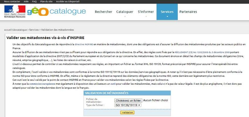
CONTEXT
VALIDATION PROCESS
FINDINGS
                     - INSPIRE DECISION
                     - CATALOG DATA LIST
                     - ISSUES ABOUT THIS LIST
                     - FRENCH CONTEXT
                     - GEOCAT VALIDATION
                     - HOW TO IMPROVE THE LIST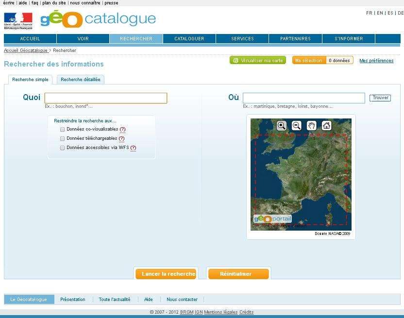
INSPIRE : COMMISSION DECISION OF 5 JUNE 2009

Article 2
Common provisions for monitoring and reporting

1. Member States shall establish a list of the spatial data sets and
    spatial data services corresponding to the themes listed in

    Annexes I, II and III to Directive 2007/2/EC,                      (grouped by theme and Annex,

   and of the network services referred to in Article 11(1) of that Directive, grouped by service type. )

They shall communicate that list to the Commission and update it
annually.
GEOCATALOG DATA LIST

A list of data has to be sent annually to the European Commission for reporting.
The France relies on Geocatalog for it.    http://www.geocatalogue.fr/

=> In France
every INSPIRE MD
has to be declared
to a single catalog
(harvesting, proposal)
A first guide help the
provider with INSPIRE
themes

ISSUES ABOUT DATASERIES LIST
Help to the Géocatalogue
Consistency with INSPIRE improvement
Monitoring the implementation, Transparency of the reporting
with possible impact on the for both CE and agencies
coordination to product geo data
Bring producers on good tracks
FRENCH CONTEXT

                                             Metadata                         Data               Services INSPIRE

                                                          My data is in INSPIRE scope

                                                      Annex I                Annex II             Annex III

                                                     2010             2010                            2013
   Step 2)                 Step 3)                 Step 1) Create metadata from my data
 Create a view            Create a
                          download                                  Discovery Service CSW                                 Step 5) Data compliance
    service
                           service

 2011                       2012                            Manage its                  Provide its
                                                            own catalog                 metadatas             straight       Transformation      Initial
  View service            Download service                                      or                                                             production
                                                            With its own                                                        By local
      WMS            Simple or by queries                   service CSW                                                        softwares            -
   ou WMS-C                 Image    WCS                        and get it                                transformations
   ou WMTS                  Vector   WFS                         harvest

                                                                                                                              Compliant data

                 Step 4) Create
                                                                                                                         Annex I       Annex II et III
                 metadata for data                                Metadata in the Geocatalog
                 services                                                                                                => 2017           => 2020
                                                                   INSPIRE Discovery service

                                        Géocatalogue acces, view in french Géoportail and european portals
GÉOCATALOGUE VALIDATION French validation tool available but none tool can learn about the correct classification of the data in the INSPIRE theme
HOW TO IMPROVE THE LIST 1) UPSTREAM OF THE LIST 2) EXTRACTION PROCESS OF THE LIST INTENDED FOR REPORTING 3) INTERVENTION IN THE LIST => CREATION OF A CNIG WORKING GROUP
CONTEXT
VALIDATION PROCESS
FINDINGS
                     - METODOLOGY
                     - SHARING THE SERIES
                     - METADATA ANALYSIS
                     - CATALOG CONTENT
                     - ANNEX 1 & 2
                     - ANNEX3
                     - RESULTS
METHODOLOGY
4 kinds of findings
Thème Thème
1er opinion 2nd opinion Decision Initial
Validation Validate Validate correct correct
proposals Thematic […] Thematic […]
made under Remove Validate Validate Proposal […] duplicate
Thematic […] Thematic […]
recommendations
Remove Non-INSPIRE Proposal […] correct
Working Group
To modify Proposal […] Same Proposal […] correct
Proposal
To debate Non-INSPIRE or different Discussion correct
proposal ProposalSHARING THE SERIES
Metadata analysis of 8.070 dataseries
C. Satra Lebris F. Lecuy L. Coudercy P. Vergez F. Salgé E.Taffoureau Marc Leobet P. Lory
(IFREMER) (SHOM) (ONEMA) (IGN-CNIG) (Environ. (BRGM) (Environ. (IGN-CNIG)
Ocean survey Hydrogr.map water survey Ministry) geological Ministry)
E.Taffoureau Laurent survey
F. Lecuy C. Satra Lebris M.Decherf F. Salgé Coudercy M. Leobet P. Lory P.Vergez
177 [EL] 1 140 [OF] 15 151 [GE] 4 208[LC] 356 [HY] 8 978 [TN] 7 223 [OI] 3 31 [RS] 1-2
Elevation Océano. Geology LandCover Hydrography Transport Orthoimager CRS+grids
Features Network y
48 [AF] 9 947 [HB] 18 63 [ER] 20 84 [BU] 2 139 [EF] 7 279 [PS] 9 11 [ACMF] 45 [GN] 3
Agricultural Habitats& Energy Buildings Environ.Moni Protected 13 Atmos. Toponymy
aqu.facilities biotopes resources Facilities sites Conditions
20 [SR] 16 187 [SD] 19 44 [MR] 21 36 [SO] 3 151 [PF] 8 83 [HH] 5 23[ACMF] 14 292 [AU] 4
Sea Regions Species Mineral Soil sites Health méteo Admin.Units.
Distribution Resource industriels
57 [ESU] 38 [BR] 17 16 [PD] 10. 1425 [LU] 4 547 [AM] 11 779[NZ] 12 369 [PS] 6 107 [AD] 5-6
Statistics Bio Regions Démogra. Land Use area Natural risc Utility Adresses+
Managment Zones services [CP]CadasterMETADATA ANALYSIS QUESTIONS THAT ARISE TO VALIDATE THE PRESENCE OF DATA IN THE LIST IS THE TYPE OF DATA IN THE INSPIRE FIELD? IS IT A DUPLICATE? IS THE INSPIRE THEME IDENTIFIED BY THE KEYWORD VALID? WHAT GRANULARITY OF METADATA TO RESPECT?
CATALOG CONTENT IN JANUARY 2014

 8000 metadata of data series recorded in Géocatalogue
                                                          Duplicate
                                                            12%
                             Correct data
                                 39%
                                                                       Thematic
                                                                      modification
                                                                       proposed
+ many                                                                   39%

special cases
example :
Non INSPIRE data, but existing
 as attribute for INSPIRE data
- future built areas                        Non-INSPIRE
                                               10%
- objectives of secure area ,
- data synthesis,
ANNEXES 1 & 2
Evolution of the theme allocation of metadata (2.849) :
2.4 Geology
2.3 Orthoimagery
2.2 Land cover
2.1 Elevation
1.9 Protected sites
1.8 Hydrography
1.7 Transport networks
1.6 Cadastral parcels
1.5 Addresses
1.4 Administrative units
1.3 Geographical names
1.1 CRS + 1.2 Geographical grid3.21 Mineral resources
ANNEX 3
3.20 Energy resources
3.19 Species distribution
3.18 Habitats and biotopes
3.17 Bio-geographical regions
Evolution of the theme
3.16 Sea regions allocation of metadata
3.15 Oceanographic geog.l features (5.221 MD)
3.14 Meteorological geog. Features
3.13 Atmospheric conditions
3.12 Natural risk zones
3.11 Area management
3.10 demography
3.9 Agricultural aquaculture facilities
3.8 Production industrial facilities
3.7 Environm.l monitoring facilities
3.6 Utility and governmental services
3.5 Human health and safety
3.4 Land use
3.3 Soil
3.2 Buildings
3.1 Statistical unitsRESULTS
Each one of the 8.070 studied metadatas
File on line: http://cnig.gouv.fr/?page_id=5963
« Liste des 8000 séries de données 2014 avec les propositions thématiques »CONTEXT
VALIDATION PROCESS
FINDINGS
- LOOKING FOR SOLUTIONS
- IMMEDIATE ACTIONS IDENTIFIED
- EXPONENTIAL INCREASE
- CONTINUOUS AUTO IMPROVEMENT
- EXERPT OF THE GUIDELOOKING FOR SOLUTIONS How manage the differences between expertises? What about the differences with the Geocatalog guide on line (first established by the ministry) => answer : we couldn’t modify what was initially proposed by the Ministry in the thesaurus Wide communication set up around the data sets list and guide What for 2015 ? …Knowing that the process analysis of the list of data series was unsuitable for future volumes
IMMEDIATES ACTIONS IDENTIFIED REFERENCE FILES TO BE CREATED File with common mistakes Recommendations Special issues to report to JRC or DGENV IMPROVE THE GEOCATALOG GUIDE Action Ministry-Hydrographic agency : Merge the 2 thesaurus Géocatalogue & SANDRE
EXPONENTIAL INCREASE IN THE AMOUNT OF METADATA
2012: 2 000 metadata of data series in the Geocatalogue
2013 : 4 000
2014 : 8 000 year of the study
2015 : 16 000
2016 : 30 000 (with cadaster = 1 and IGN =30)
2017 : 50 000?
2018 : 100 000 (forecasted since 2012)
Henceforth
- first priority is to build national layers.
- new challenge is to move from quantitative to qualitative analysis,CONTINUOUS AUTO IMPROVEMENT Knowing that the manual method won’t be anymore operative and annual results become too difficult to analyze, FINALLY IT WAS DECIDED THAT THE EASIEST WAY IS NOW ACCEPTING A GRADUAL UPGRADE OF THE METADATA CLASSIFICATION AS AWARENESS OF PRODUCERS HELPED BY THE GEOCATALOG GUIDE A quantitative analyze can be done via the European dashboard : https://inspire-dashboard.eea.europa.eu/official/dashboard2/#/dashboard/solr/INSPIRE%20Indicator%20trends
EXCERPT FROM THE GUIDE GEOCATALOGUE
                                              http://www.geocatalogue.fr/#!HelpCatalogue
 Aerial Orthoimagery            (2.3 Orthoimagery)
 Building 2D or 2.5D            (3.2 Buildings)                  Chapter :
 Building 3D                    (3.2 Buildings)    « Physical Description of territory »
 Change of slope line           (2.1 Elevation)
 Digital Elevation Mode (MNT)   (2.1 Elevation)
 Elevation line                 (2.1 Elevation)
 Hypsometric area               (2.1 Elevation)
 Inhabited Locality             (1.3 Geogr. names)
 Irregular Triangular network   (2.1 Elevation)
 Land cover Grid                (2.2 Land cover)
 Land cover points              (2.2 Land cover)
 Land cover polygons            (2.2 Land cover)
 Locality                       (1.3 Geogr. names)
 Satellite Orthoimagery         (2.3 Orthoimagery)
 Sea shore line                 (3.16 Sea regions)
 Slope                          (2.1 Elevation)
 Spot height                    (2.1 Elevation)
 Umbrage                        (2.1 Elevation)
                                                                Source : Benoit DAVID
 Uninhabited Locality           (1.3 Geogr. names)              MEEM/CGDD/DRI/MIG
KEN 2016 ENSG
The French INSPIRE Coordinating structure
« validation »
….Questions ?
?
CNIG.gouv.frYou can also read